The Half-Moon Technique [Benin]
- Creation:
- Update:
- Compiler: Gatien AGBOKOUN CHRISTOPHE
- Editors: Siagbé Golli, Abdoul Karim MIEN, DOSSOU-YOVO bernardin, Tabitha Nekesa, Ahmadou Gaye
- Reviewers: Sally Bunning, William Critchley
Soun man kpéka
technologies_6652 - Benin
View sections
Expand all Collapse all1. General information
1.2 Contact details of resource persons and institutions involved in the assessment and documentation of the Technology
Key resource person(s)
SLM specialist:
OGOUDEDJI Bérenger
Paroisse de Setto / ProSOL / GIG
Benin
land user:
NANKPAN Joseph
Paroisse de Seto / ProSOL / GIG
Name of project which facilitated the documentation/ evaluation of the Technology (if relevant)
Soil protection and rehabilitation for food security (ProSo(i)l)1.3 Conditions regarding the use of data documented through WOCAT
The compiler and key resource person(s) accept the conditions regarding the use of data documented through WOCAT:
Yes
1.4 Declaration on sustainability of the described Technology
Is the Technology described here problematic with regard to land degradation, so that it cannot be declared a sustainable land management technology?
No
2. Description of the SLM Technology
2.1 Short description of the Technology
Definition of the Technology:
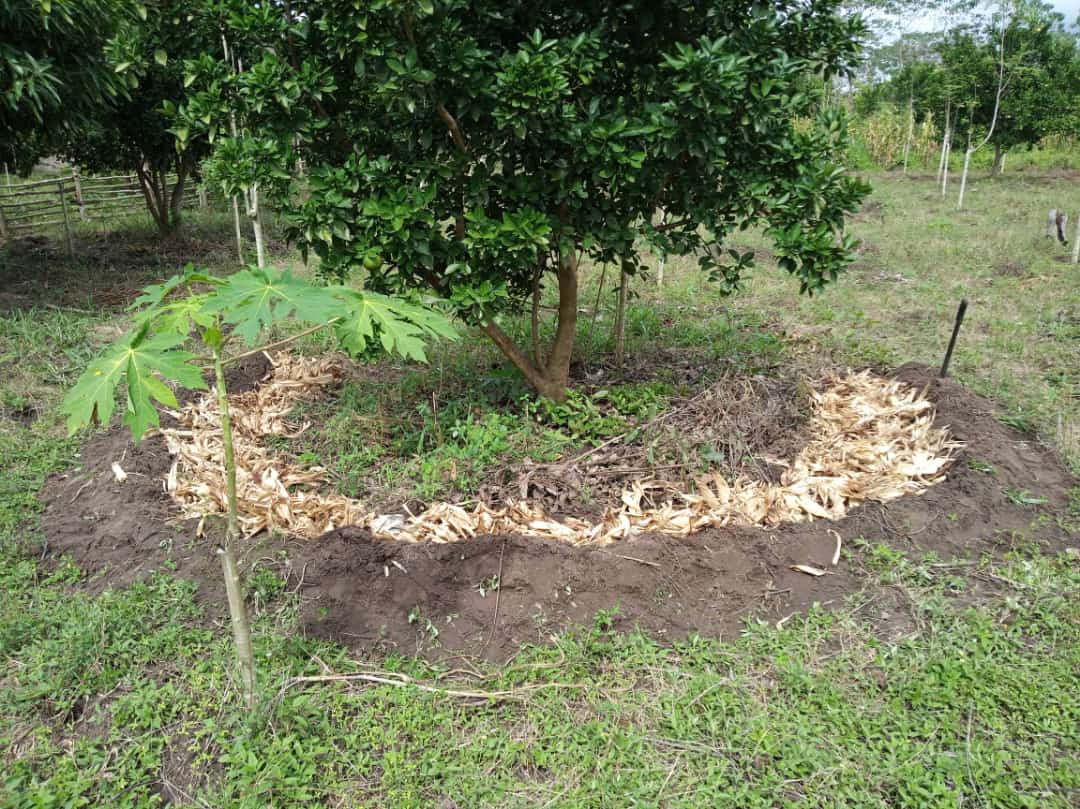
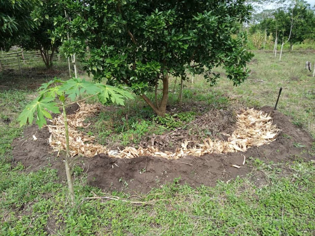
The half-moon technique is designed to enhance water retention and soil infiltration. This is achieved by constructing crescent-shaped mounds around the base of trees. A compass can be used to outline a semi-circle with a diameter of 4 meters. The soil within this outlined area is then excavated and used to form a ridge.
2.2 Detailed description of the Technology
Description:
The half-moon technique is commonly used on sloping land in arid or semi-arid climates, especially for fruit plantations such as cashew and orange trees. It involves clearing the ground to create basin-like structures, which are a few meters in diameter and bordered by ridges. This technique is essentially used to (i) cultivate encrusted land, (ii) reduce runoff, (iii) concentrate rainwater at the foot of trees by improving its infiltration into the soil, (iv) induce early flowering of fruit trees, (v) improve fruit tree production and (vi) restore biological diversity to agroecosystems.
The protocol for installing the technique is as follows :
-Use a compass with a 2-meter radius to pivot and create the half-moon shape;
-Use a pick, pickaxe, and shovel to dig the half-moon to a depth of 15 to 20 cm;
-Build the ridges starting from the inside and working outward. The height of the ridges can vary, depending on the slope severity, but can reach up to 40 cm;
-Arrange the half-moons in a staggered pattern perpendicular to the slope or following the contour lines; and
-Maintain a 4-metre spacing between two rows of half-moons.
It is recommended to enrich the half-moons with organic fertilizer or well-decomposed compost. Depending on availability, up to 35 kg of compost or manure, or a wheelbarrow full, could be added to each half-moon. Once the half-moon has been installed, it is recommended that it be systematically mulched to minimize moisture loss.
The half-moon technique can be implemented at any time of the year, but preferably in February-March or August-September on orange and cashew trees, to maintain structures designed to collect runoff water. To ensure the longevity of the technique, it is advisable to reshape larger ridges whenever their size diminishes, to strengthen the barrier.
2.3 Photos of the Technology
2.5 Country/ region/ locations where the Technology has been applied and which are covered by this assessment
Country:
Benin
Region/ State/ Province:
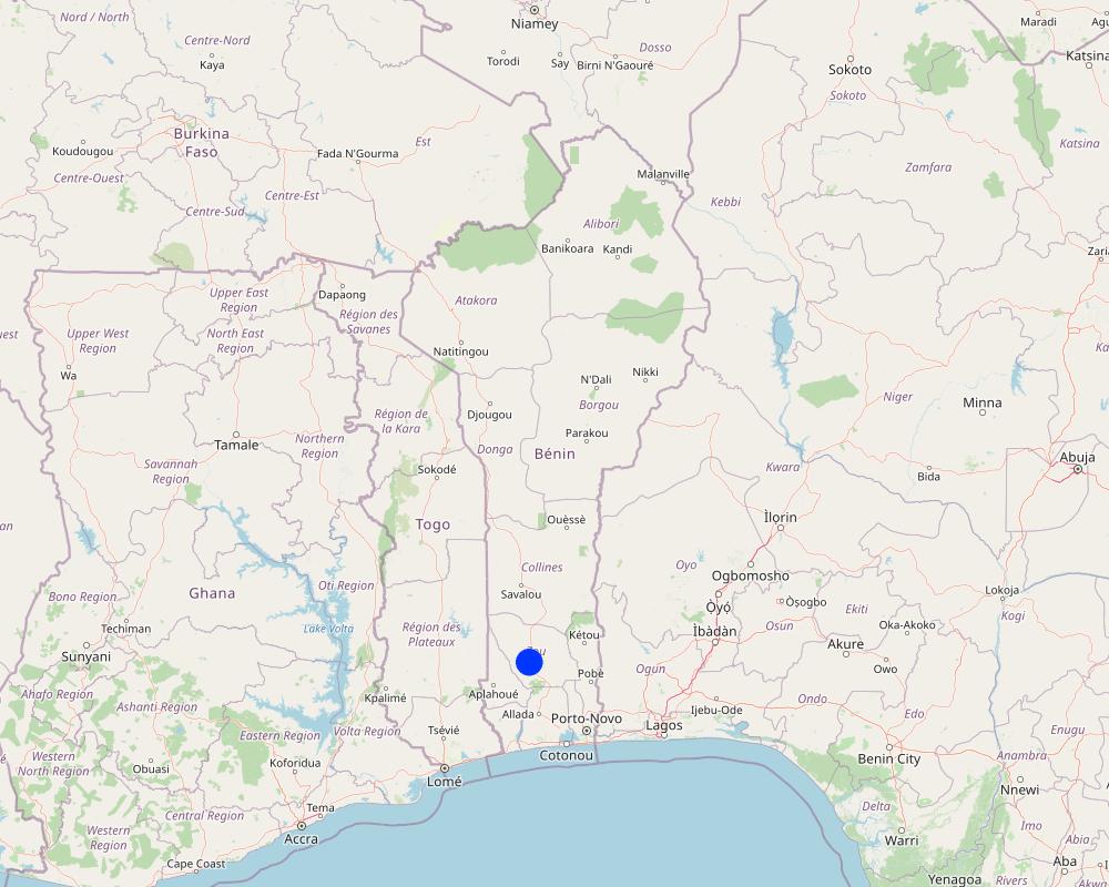
Bohicon
Specify the spread of the Technology:
- evenly spread over an area
If the Technology is evenly spread over an area, specify area covered (in km2):
2.0
Is/are the technology site(s) located in a permanently protected area?
No
Map
×2.6 Date of implementation
Indicate year of implementation:
2020
2.7 Introduction of the Technology
Specify how the Technology was introduced:
- through projects/ external interventions
Comments (type of project, etc.):
The half-moon technology was implemented under the German Cooperation-funded Soil Rehabilitation and Restoration Project (ProSOL)
3. Classification of the SLM Technology
3.1 Main purpose(s) of the Technology
- improve production
- reduce, prevent, restore land degradation
- conserve ecosystem
- adapt to climate change/ extremes and its impacts
- create beneficial economic impact
3.2 Current land use type(s) where the Technology is applied
Land use mixed within the same land unit:
No

Cropland
- Tree and shrub cropping
- Orangers
Number of growing seasons per year:
- 1
Is intercropping practiced?
No
Is crop rotation practiced?
No
3.3 Has land use changed due to the implementation of the Technology?
Has land use changed due to the implementation of the Technology?
- Yes (Please fill out the questions below with regard to the land use before implementation of the Technology)
Land use mixed within the same land unit:
No

Cropland
- Annual cropping
Annual cropping - Specify crops:
- legumes and pulses - other
- Mucuna
Is intercropping practiced?
No
Is crop rotation practiced?
No
3.4 Water supply
Water supply for the land on which the Technology is applied:
- rainfed
3.5 SLM group to which the Technology belongs
- agroforestry
- integrated soil fertility management
- water harvesting
3.6 SLM measures comprising the Technology

agronomic measures
- A1: Vegetation/ soil cover
- A2: Organic matter/ soil fertility
3.7 Main types of land degradation addressed by the Technology

soil erosion by water
- Wt: loss of topsoil/ surface erosion

biological degradation
- Bl: loss of soil life
3.8 Prevention, reduction, or restoration of land degradation
Specify the goal of the Technology with regard to land degradation:
- reduce land degradation
- adapt to land degradation
4. Technical specifications, implementation activities, inputs, and costs
4.1 Technical drawing of the Technology
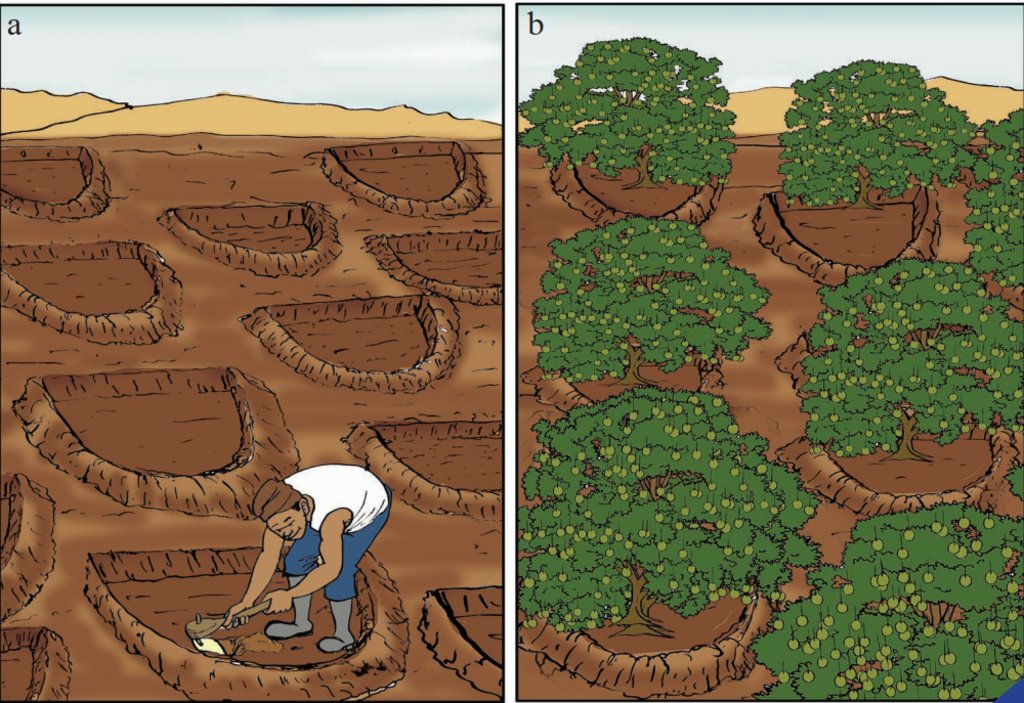
Technical specifications (related to technical drawing):
The installation protocol involves the following steps:
-Establish the half-moon by pivoting using a compass with a 2-meter radius.
-Use a pick, pickaxe, and shovel to open the half-moon to a depth of 15 to 20 cm.
-Use a pickaxe to dig an area of approximately 6.283 square meters.
-Place the excavated earth on the semicircle, creating a semicircular ridge with a flattened top.
-Arrange the half-moons in a staggered pattern perpendicular to the slope or following the contour lines. Ensure that the arc is intercepted at the slope, allowing the water runoff to be struck by the crest of the ground.
-Maintain a spacing of 4m between two series of half-moons. In one hectare, a total of 625 half-moons should be planted.
-Before sowing, add 35 kg of compost or manure (equivalent to one wheelbarrow) to each half-moon.
-Note that the surface of the half-moon can be utilized for planting crops or perennial crops.
4.2 General information regarding the calculation of inputs and costs
Specify how costs and inputs were calculated:
- per Technology unit
Specify unit:
1 half moon
Specify dimensions of unit (if relevant):
6.283 square meters
other/ national currency (specify):
CFA F
If relevant, indicate exchange rate from USD to local currency (e.g. 1 USD = 79.9 Brazilian Real): 1 USD =:
615.18
Indicate average wage cost of hired labour per day:
2000
4.3 Establishment activities
| Activity | Timing (season) | |
|---|---|---|
| 1. | Sourcing the straw | January |
| 2. | Demarcation of the semi-circles | April |
| 3. | Digging to create ridges | April |
| 4. | Mulching | April |
4.4 Costs and inputs needed for establishment
| Specify input | Unit | Quantity | Costs per Unit | Total costs per input | % of costs borne by land users | |
|---|---|---|---|---|---|---|
| Labour | Sourcing the straw | Half moon | 625.0 | 50.0 | 31250.0 | 100.0 |
| Labour | Demarcation of the semi-circles | Half moon | 625.0 | 50.0 | 31250.0 | 100.0 |
| Labour | Digging to create ridges | Half moon | 625.0 | 100.0 | 62500.0 | 100.0 |
| Equipment | Pickaxe or daba | Unit | 3500.0 | 1.0 | 3500.0 | 100.0 |
| Construction material | Straw | Half moon | 625.0 | 50.0 | 31250.0 | 100.0 |
| Construction material | Compost | Half moon | 625.0 | 1000.0 | 625000.0 | 99.0 |
| Total costs for establishment of the Technology | 784750.0 | |||||
| Total costs for establishment of the Technology in USD | 1275.64 | |||||
4.5 Maintenance/ recurrent activities
| Activity | Timing/ frequency | |
|---|---|---|
| 1. | Addition of manure or compost | June to July |
| 2. | Weeding | June to October |
| 3. | Filling in collapsed areas (due to water) | June to September |
| 4. | Mulching | June to September |
4.6 Costs and inputs needed for maintenance/ recurrent activities (per year)
| Specify input | Unit | Quantity | Costs per Unit | Total costs per input | % of costs borne by land users | |
|---|---|---|---|---|---|---|
| Labour | Maintenance/Weeding | Half moon | 625.0 | 25.0 | 15625.0 | 100.0 |
| Labour | Mulching | Half moon | 625.0 | 25.0 | 15625.0 | 100.0 |
| Labour | Filling in collapsed areas (due to water) | Half moon | 625.0 | 50.0 | 31250.0 | 100.0 |
| Fertilizers and biocides | Addition of manure or compost | Half moon | 625.0 | 100.0 | 62500.0 | 100.0 |
| Total costs for maintenance of the Technology | 125000.0 | |||||
| Total costs for maintenance of the Technology in USD | 203.19 | |||||
4.7 Most important factors affecting the costs
Describe the most determinate factors affecting the costs:
Salaried labour is a limiting factor affecting costs.
5. Natural and human environment
5.1 Climate
Annual rainfall
- < 250 mm
- 251-500 mm
- 501-750 mm
- 751-1,000 mm
- 1,001-1,500 mm
- 1,501-2,000 mm
- 2,001-3,000 mm
- 3,001-4,000 mm
- > 4,000 mm
Specify average annual rainfall (if known), in mm:
1025.00
Agro-climatic zone
- sub-humid
Bohicon is characterized by a tropical climate, featuring a very hot and dry season from December to February, and a rainy season extending from mid-March to October.
5.2 Topography
Slopes on average:
- flat (0-2%)
- gentle (3-5%)
- moderate (6-10%)
- rolling (11-15%)
- hilly (16-30%)
- steep (31-60%)
- very steep (>60%)
Landforms:
- plateau/plains
- ridges
- mountain slopes
- hill slopes
- footslopes
- valley floors
Altitudinal zone:
- 0-100 m a.s.l.
- 101-500 m a.s.l.
- 501-1,000 m a.s.l.
- 1,001-1,500 m a.s.l.
- 1,501-2,000 m a.s.l.
- 2,001-2,500 m a.s.l.
- 2,501-3,000 m a.s.l.
- 3,001-4,000 m a.s.l.
- > 4,000 m a.s.l.
Indicate if the Technology is specifically applied in:
- concave situations
5.3 Soils
Soil depth on average:
- very shallow (0-20 cm)
- shallow (21-50 cm)
- moderately deep (51-80 cm)
- deep (81-120 cm)
- very deep (> 120 cm)
Soil texture (topsoil):
- coarse/ light (sandy)
- fine/ heavy (clay)
Soil texture (> 20 cm below surface):
- coarse/ light (sandy)
Topsoil organic matter:
- medium (1-3%)
5.4 Water availability and quality
Ground water table:
5-50 m
Availability of surface water:
medium
Water quality (untreated):
good drinking water
Water quality refers to:
ground water
Is water salinity a problem?
No
Is flooding of the area occurring?
No
5.5 Biodiversity
Species diversity:
- medium
Habitat diversity:
- medium
5.6 Characteristics of land users applying the Technology
Sedentary or nomadic:
- Sedentary
Market orientation of production system:
- mixed (subsistence/ commercial)
Off-farm income:
- less than 10% of all income
Relative level of wealth:
- average
Individuals or groups:
- individual/ household
- groups/ community
Level of mechanization:
- manual work
Gender:
- women
- men
Age of land users:
- youth
- middle-aged
5.7 Average area of land used by land users applying the Technology
- < 0.5 ha
- 0.5-1 ha
- 1-2 ha
- 2-5 ha
- 5-15 ha
- 15-50 ha
- 50-100 ha
- 100-500 ha
- 500-1,000 ha
- 1,000-10,000 ha
- > 10,000 ha
Is this considered small-, medium- or large-scale (referring to local context)?
- small-scale
Comments:
The average land area available is no longer adequate to fulfill the needs of the increasing population.
5.8 Land ownership, land use rights, and water use rights
Land ownership:
- communal/ village
Land use rights:
- communal (organized)
Water use rights:
- communal (organized)
- leased
Are land use rights based on a traditional legal system?
Yes
Specify:
The village has land chiefs responsible for managing and organizing land use.
5.9 Access to services and infrastructure
health:
- poor
- moderate
- good
education:
- poor
- moderate
- good
technical assistance:
- poor
- moderate
- good
employment (e.g. off-farm):
- poor
- moderate
- good
markets:
- poor
- moderate
- good
energy:
- poor
- moderate
- good
roads and transport:
- poor
- moderate
- good
drinking water and sanitation:
- poor
- moderate
- good
financial services:
- poor
- moderate
- good
6. Impacts and concluding statements
6.1 On-site impacts the Technology has shown
Socio-economic impacts
Production
crop production
Comments/ specify:
Applied to citrus fruits (orange trees), the technology has resulted in a doubling of seedling production.
risk of production failure
production area
land management
Income and costs
expenses on agricultural inputs
Comments/ specify:
Half-moons are costly to create but beneficial in terms of results.
farm income
economic disparities
workload
Comments/ specify:
Half-moon application is labor-intensive.
Socio-cultural impacts
food security/ self-sufficiency
health situation
Comments/ specify:
Improved income means better access to health services.
recreational opportunities
SLM/ land degradation knowledge
situation of socially and economically disadvantaged groups
Ecological impacts
Soil
soil moisture
soil cover
Biodiversity: vegetation, animals
biomass/ above ground C
Climate and disaster risk reduction
drought impacts
fire risk
6.3 Exposure and sensitivity of the Technology to gradual climate change and climate-related extremes/ disasters (as perceived by land users)
Gradual climate change
Gradual climate change
| Season | increase or decrease | How does the Technology cope with it? | |
|---|---|---|---|
| annual temperature | increase | moderately | |
| seasonal temperature | dry season | increase | well |
| annual rainfall | decrease | well | |
| seasonal rainfall | wet/ rainy season | decrease | well |
6.4 Cost-benefit analysis
How do the benefits compare with the establishment costs (from land users’ perspective)?
Short-term returns:
slightly positive
Long-term returns:
very positive
How do the benefits compare with the maintenance/ recurrent costs (from land users' perspective)?
Short-term returns:
slightly positive
Long-term returns:
positive
6.5 Adoption of the Technology
- 11-50%
If available, quantify (no. of households and/ or area covered):
50 ha
Of all those who have adopted the Technology, how many did so spontaneously, i.e. without receiving any material incentives/ payments?
- 11-50%
Comments:
Observing the positive impacts on other producers, some late adopters did not require encouragement. They embraced the technique on their own.
6.6 Adaptation
Has the Technology been modified recently to adapt to changing conditions?
No
6.7 Strengths/ advantages/ opportunities of the Technology
| Strengths/ advantages/ opportunities in the land user’s view |
|---|
| Enhanced soil fertility; increased crop yields |
| Facilitation of water infiltration |
| Water and wind erosion control |
| Strengths/ advantages/ opportunities in the compiler’s or other key resource person’s view |
|---|
| Rainwater catchment |
| Resistance to climatic hazards; high retention capacity for vegetal matter and dissolved particles |
6.8 Weaknesses/ disadvantages/ risks of the Technology and ways of overcoming them
| Weaknesses/ disadvantages/ risks in the land user’s view | How can they be overcome? |
|---|---|
| Labour-intensive | Combine workers (salaried and family) for synergistic action |
| Very slow soil restoration speed | Add organic matter |
| Flooding of the excavated surface during heavy rains | Drain in the event of flooding, since the technology is more suited to arid and semi-arid zones |
| Weaknesses/ disadvantages/ risks in the compiler’s or other key resource person’s view | How can they be overcome? |
|---|---|
| Compost or organic fertilizer required | Mineral fertilizers to be added if compost or manure is difficult to produce |
| Very slow soil restoration speed | Use of mineral fertilizers before the start of the fertilizing process |
7. References and links
7.1 Methods/ sources of information
- field visits, field surveys
4
- interviews with land users
1
- interviews with SLM specialists/ experts
2
When were the data compiled (in the field)?
01/16/2023
7.2 References to available publications
Title, author, year, ISBN:
Deutsche Gesellschaft für Internationale Zusammenarbeit (GIZ) GmbH, 2018. Compendium de fiches techniques du formateur
Title, author, year, ISBN:
Deutsche Gesellschaft für Internationale Zusammenarbeit (GIZ) GmbH, 2018. Mesures de Gestion Durable des Terres (GDT) et d’Adaptation au Changement Climatique (ACC) : Boîte à images pour l’animation des séances de formation avec les agriculteurs
7.3 Links to relevant online information
Title/ description:
Communal Approach to the Agricultural Market (Phase 2) INTEGRATED SOIL FERTILITY MANAGEMENT (ISFM)
URL:
https://ifdc.org/wp-content/uploads/2019/07/FICHE-TECHNIQUE-1-GESTION-INTEGREE-DE-LA-FERTILITE-DES-SOLS-ET-PRINCIPES-DE-BASE-INTEGRATED-MANAGEMENT-OF-SOIL-FERTILITY-AND-BASIC-PRINCIPLES.pdf
Links and modules
Expand all Collapse allLinks
No links
Modules
No modules


