Forest catchment treatment [India]
- Creación:
- Actualización:
- Compilador: Chetan Kumar
- Editor: –
- Revisores: Fabian Ottiger, Alexandra Gavilano
technologies_1476 - India
Visualizar secciones
Expandir todo Colapsar todos1. Información general
1.2 Detalles de contacto de las personas de referencia e instituciones involucradas en la evaluación y la documentación de la Tecnología
Especialista MST:
Vashisth US
India
Nombre del proyecto que financió la documentación/ evaluación de la Tecnología (si fuera relevante)
Book project: where the land is greener - Case Studies and Analysis of Soil and Water Conservation Initiatives Worldwide (where the land is greener)Nombre de la(s) institución(es) que facilitaron la documentación/ evaluación de la Tecnología (si fuera relevante)
Center for International Forestry Research (CIFOR) (Center for International Forestry Research (CIFOR)) - India1.3 Condiciones referidas al uso de datos documentados mediante WOCAT
El compilador y la/s persona(s) de referencia claves aceptan las condiciones acerca del uso de los datos documentados mediante WOCAT:
Sí
1.5 Referencia al (los) Cuestionario(s) de Enfoques MST (documentados usando WOCAT)

Joint forest management [India]
Government and NGO supported community protection of forested catchments, through village-based Hill Resource Management Societies.
- Compilador: Sumana Datta
Joint forest management [India]
Joint forest management is a community based program developed in collaboration with the forest department for the protection and management of local forests while providing incentives to the local communities with political and institutional support from the state.
- Compilador: Sumana Datta
2. Descripción de la Tecnología MST
2.1 Breve descripción de la Tecnología
Definición de la Tecnología:
Catchment treatment of degraded forest land including social fencing, infiltration trenches and enrichment planting with trees and grasses for production and dam protection.
2.2 Descripción detallada de la Tecnología
Descripción:
Forest catchment treatment aims to achieve production and environmental benefits through a combination of structural, vegetative and management measures in badly degraded catchments above villages. These efforts are concentrated in the highly erodible Shiwalik Hills at the foot of the Himalayan range where soil erosion has ravaged the landscape, and the original forest has almost disappeared.
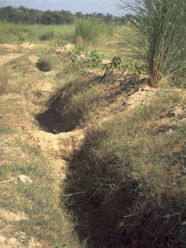
The purpose of forest catchment treatment is first to rehabilitate the forest through protection of the area by ‘social fencing’ (villagers agreeing amongst themselves to exclude livestock without using physical barriers), then construction of soil conservation measures (staggered contour trenches, check dams, graded stabilisation channels etc; see establishment activities), and ‘enrichment planting’ of trees and grasses within the existing forest stand to improve composition and cover. These species usually include trees such as Acacia catechu and Dalbergia sissoo, and fodder grasses - as well as bhabbar grass (Eulaliopsis binata), which is used for rope making. The combined measures are aimed at reestablishing the forest canopy, understorey and floor, thereby restoring the forest ecosystem together with its functions and services. Biodiversity is simultaneously enhanced.
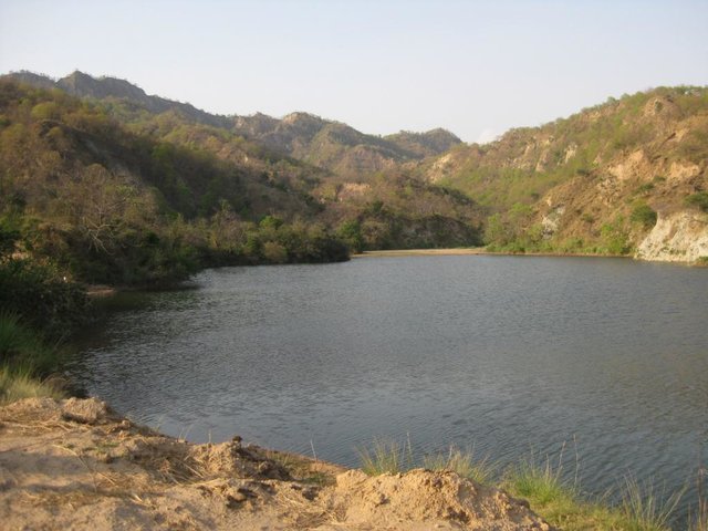
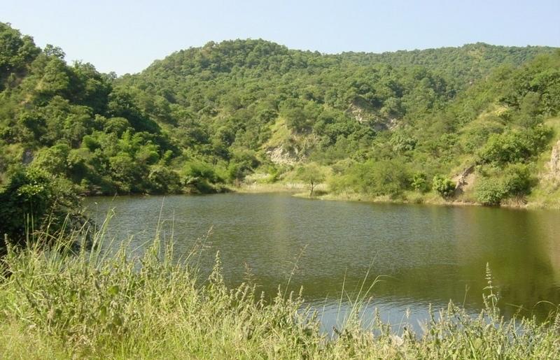
The second main objective is to provide supplementary irrigation water to the village below through construction of one, or more, earth dams. The village community - organised into a Hill Resource Management Society - is the source of highly subsidised labour for forest catchment treatment. After catchment protection around the proposed dam site(s), the dam(s) and pipeline(s) are constructed. The dams are generally between 20,000 and 200,000 m3 in capacity, and the pipelines usually one kilometre or less in length.
Apart from irrigation, the villagers benefit from communal use of non-timber forest resources. Forest catchment treatment (associated with the approach termed ‘joint forest management’ - JFM) has been developed from a pilot initiative in Sukhomajri village in 1976, and has spread very widely throughout India. This description focuses on Ambala and Yamunanagar Districts in Haryana State.
The Shiwalik hills where the SWC technology was applied is one of the eight most degraded, rainfed agro-ecosystems of India. It is highly erodible, with presence of low water retentive soils and severe soil erosion, haing water scarcity despite average 1000 mm annual rainfall.
2.3 Fotografías de la Tecnología
Galería de medios
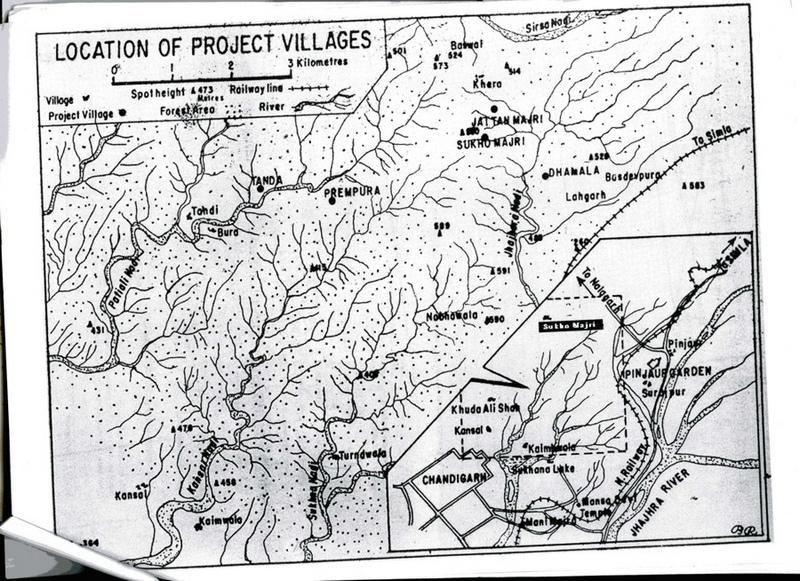
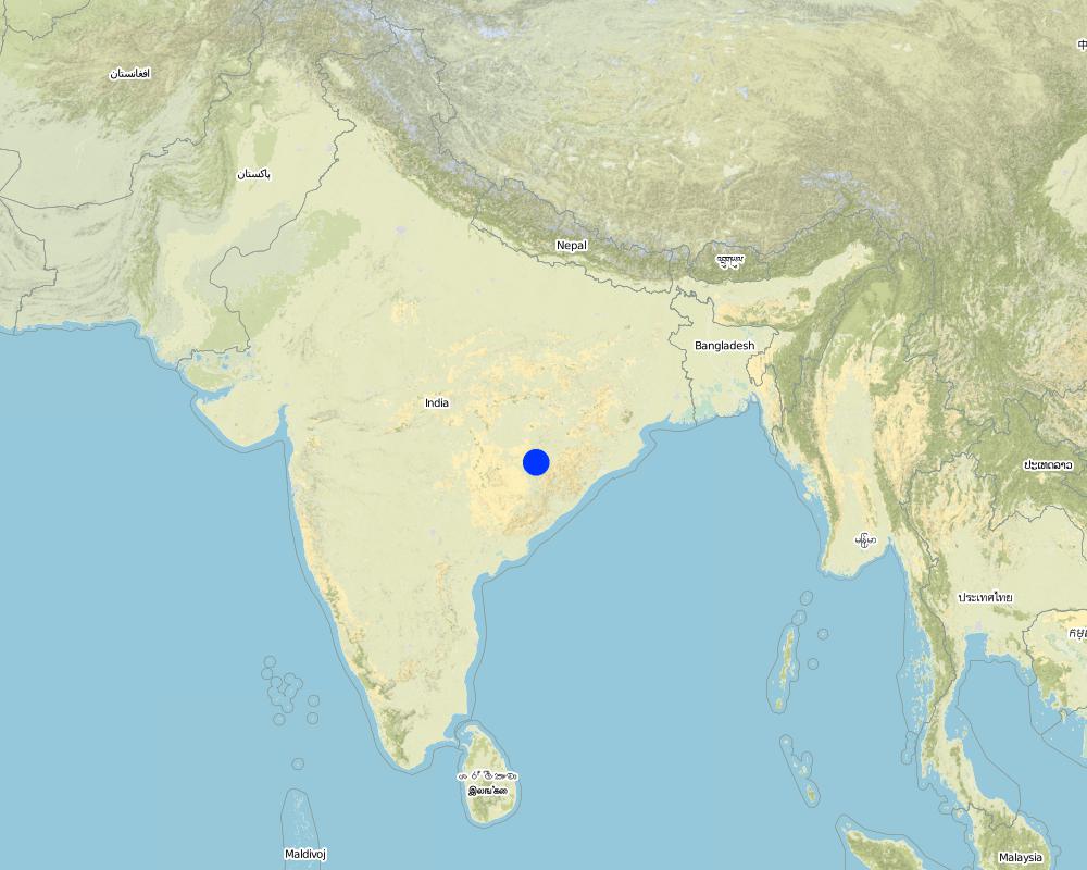
2.5 País/ región/ lugares donde la Tecnología fue aplicada y que se hallan comprendidos por esta evaluación
País:
India
Región/ Estado/ Provincia:
Haryana
Especifique más el lugar :
Ambala and Yamunanagar
Comentarios:
Total area covered by the SLM Technology is 198 km2.
Map
×3. Clasificación de la Tecnología MST
3.1 Propósito(s) principal(es) de la Tecnología MST
- mejorar la producción
- reducir, prevenir, restaurar la degradación del suelo
3.2 Tipo(s) actuales de uso de la tierra donde se aplica la Tecnología
Mezcla de tipos de uso de tierras dentro de la misma unidad de tierras: :
Sí
Especifique el uso combinado de tierras (cultivos/ pastoreo/ árboles):
- Silvo-pastoralismo

Tierra de pastoreo

Bosques
- Rehabilitated natural forest
Tipo de árbol:
- Especies de Acacia
- Dalbergia sissoo
Comentarios:
Major land use problems (compiler’s opinion): The Shiwalik Hills are extremely prone to both surface erosion and landslides, and general degradation of vegetation due to over-exploitation. Some areas have become completely denuded because of overgrazing and woodcutting. Furthermore there is no, or inadequate, water for irrigation of crops.
Grazingland comments: Due to free grazing, much of the forest land was becoming barren and fodder yield declined over a period of time. The average fodder yield was about two quintals/ha of forest land and fodder consumption was 26.69kg/animal/day.
Problems / comments regarding forest use: Tree species like Khaci (Acacia catechu), Dalbergio sissoo in pits and slips of bhabbar grass (Eulaliopsis binata) on mounds of trenches and hill slopes were planted. Bhabbar grass was sold out by forest department to contractors.
Type of grazing system comments: Due to free grazing, much of the forest land was becoming barren and fodder yield declined over a period of time. The average fodder yield was about two quintals/ha of forest land and fodder consumption was 26.69kg/animal/day.
Longest growing period in days: 120 Longest growing period from month to month: Jul - Oct
3.5 Grupo MST al que pertenece la Tecnología
- veda de zona (detener uso, apoyar la restauración)
- cobertura de suelo/ vegetal mejorada
- medida de pendiente transversal
3.6 Medidas MST que componen la Tecnología

medidas estructurales
Comentarios:
Main measures: structural measures
Secondary measures: vegetative measures, management measures
3.7 Principales tipos de degradación del suelo encarados con la Tecnología

erosión de suelos por agua
- Wt: pérdida de capa arable/ erosión de la superficie
- Wg: erosión en cárcavas
- Wm: movimiento de masas / deslizamientos de tierra

degradación del agua
- Ha: aridificación
Comentarios:
Main type of degradation addressed: Wt: loss of topsoil / surface erosion
Secondary types of degradation addressed: Wg: gully erosion / gullying, Wm: mass movements / landslides, Ha: aridification
Main causes of degradation: deforestation / removal of natural vegetation (incl. forest fires), education, access to knowledge and support services (Absence of institutional arrangements to disseminate the knowledge from lab to land and involve the users in implementation)
Secondary causes of degradation: overgrazing (Subsistence economy, dependance on forests for fuelwood and fodder, livestock were low quality, free grazing type. And these were no regulatory mechanisms to share usufruct from forests with people.), poverty / wealth (Lack of capital at the grassroot to take the initiative by the farmers themselves)
3.8 Prevención, reducción o restauración de la degradación del suelo
Especifique la meta de la Tecnología con relación a la degradación de la tierra:
- reducir la degradación del suelo
4. Especificaciones técnicas, actividades de implementación, insumos y costos
4.1 Dibujo técnico de la Tecnología
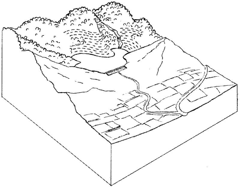
Especificaciones técnicas (relacionadas al dibujo técnico):
Forest catchment treatment: an overview showing protected forest, dam and irrigated cropland below.
Technical knowledge required for field staff / advisors: moderate
Technical knowledge required for land users: moderate
Main technical functions: increase of infiltration, water harvesting / increase water supply
Secondary technical functions: control of dispersed runoff: retain / trap, improvement of ground cover, control of concentrated runoff
Vegetative measure: enrichment planting with
Vegetative material: T : trees / shrubs, G : grass
Vegetative measure: Vegetative material: T : trees / shrubs, G : grass
Vegetative measure: Vegetative material: T : trees / shrubs, G : grass
Vegetative measure: Vegetative material: T : trees / shrubs, G : grass
Trees/ shrubs species: Acacia catechu, Dalbergia sissoo etc
Grass species: bhabbar grass: Eulaliopsis binata
Structural measure: dam
Structural measure: trenches
Structural measure: ditches
Structural measure: check dams
Other type of management: social fencing
Autor:
Mats Gurtner
4.3 Actividades de establecimiento
| Actividad | Momento (estación) | |
|---|---|---|
| 1. | Enrichment planting of tree seedlings (Acacia catechu, Dalbergiasissoo etc), grasses (bhabbar grass: Eulaliopsis binata) on bundsof earth and hill slopes, and Ipomea cornea in channels. | beginning of the monsoon rains. |
| 2. | Construction of a series of staggered contour trenches on slopes. | pre-monsoon |
| 3. | Construction of stone/earth/wood check dams in gullies. | pre-monsoon |
| 4. | Construction of graded stabilisation channels which capture runoffand discharge it safely. | pre-monsoon |
| 5. | Construction of earth dam wall for water harvesting and concretepipelines for irrigation. | pre-monsoon |
| 6. | Introduction of social fencing system through Hill ResourceManagement Societies. | pre-monsoon |
4.4 Costos e insumos necesarios para el establecimiento
| Especifique insumo | Unidad | Cantidad | Costos por unidad | Costos totales por insumo | % de los costos cubiertos por los usuarios de las tierras | |
|---|---|---|---|---|---|---|
| Mano de obra | Labour | ha | 1,0 | 250,0 | 250,0 | 5,0 |
| Equipo | Machine use | ha | 1,0 | 75,0 | 75,0 | |
| Material para plantas | Seedlings | ha | 1,0 | 50,0 | 50,0 | |
| Material de construcción | Construction material for dam wall | ha | 1,0 | 25,0 | 25,0 | |
| Costos totales para establecer la Tecnología | 400,0 | |||||
| Costos totales para establecer la Tecnología en USD | 400,0 | |||||
Comentarios:
Duration of establishment phase: 36 month(s)
4.5 Actividades de establecimiento/ recurrentes
| Actividad | Momento/ frequencia | |
|---|---|---|
| 1. | watch and ward | /on-going |
| 2. | Desilting of water harvesting structures. | pre-monsoon,/once every year |
| 3. | Repair of channels. | pre-monsoon,/once every year |
| 4. | Maintenance of structures. | pre-monsoon,/ |
| 5. | regular meetings/facilitations | |
| 6. | control grazing fines, peer-group pressure |
4.6 Costos e insumos necesarios para actividades de mantenimiento/ recurrentes (por año)
| Especifique insumo | Unidad | Cantidad | Costos por unidad | Costos totales por insumo | % de los costos cubiertos por los usuarios de las tierras | |
|---|---|---|---|---|---|---|
| Mano de obra | Labour | ha | 1,0 | 50,0 | 50,0 | 95,0 |
| Indique los costos totales para mantenecer la Tecnología | 50,0 | |||||
| Costos totales para mantener la Tecnología en USD | 50,0 | |||||
Comentarios:
This information is indicative and is based on calculations derived from Thaska village (Yamunanagar District)
where there are 3 dams - collecting the runoff from the total forest catchment of 75 ha. The cost range of treatments per
hectare of rehabilitated forest is generally US$ 200–700 (where the main cost is that of the dam construction) and typically the area of supplementary irrigation (command area) is twice as large as the forest catchment treated (in this case the irrigated area is 150 ha).
Cost per unit: the treatment of a 25 ha unit of catchment including construction of a dam costs around US$ 10,000.
5. Entorno natural y humano
5.1 Clima
Lluvia anual
- < 250 mm
- 251-500 mm
- 501-750 mm
- 751-1,000 mm
- 1,001-1,500 mm
- 1,501-2,000 mm
- 2,001-3,000 mm
- 3,001-4,000 mm
- > 4,000 mm
Zona agroclimática
- Sub-húmeda
- semi-árida
Semi arid: Shiwalik region falls under semi-arid agro-climatic zone.
5.2 Topografía
Pendientes en promedio:
- plana (0-2 %)
- ligera (3-5%)
- moderada (6-10%)
- ondulada (11-15%)
- accidentada (16-30%)
- empinada (31-60%)
- muy empinada (>60%)
Formaciones telúricas:
- meseta/ planicies
- cordilleras
- laderas montañosas
- laderas de cerro
- pies de monte
- fondo del valle
Zona altitudinal:
- 0-100 m s.n.m.
- 101-500 m s.n.m.
- 501-1,000 m s.n.m
- 1,001-1,500 m s.n.m
- 1,501-2,000 m s.n.m
- 2,001-2,500 m s.n.m
- 2,501-3,000 m s.n.m
- 3,001-4,000 m s.n.m
- > 4,000 m s.n.m
Comentarios y especificaciones adicionales sobre topografía :
Landforms: Hill slopes (ranked 1, Higher hills are located in the northern and eastern part of the tract, while low hills in the southern and western parts of the tract. These hills are characterized by relatively high intensity of er), ridges (ranked 2) and footslopes (ranked 3)
Slopes on average: Moderate (ranked 1, the slopes vary considerably from moderate to precipitous), hilly (ranked 2) and steep (ranked 3)
5.3 Suelos
Profundidad promedio del suelo:
- muy superficial (0-20 cm)
- superficial (21-50 cm)
- moderadamente profunda (51-80 cm)
- profunda (81-120 cm)
- muy profunda (>120 cm)
Textura del suelo (capa arable):
- áspera/ ligera (arenosa)
Materia orgánica de capa arable:
- media (1-3%)
- baja (<1%)
Si se halla disponible, adjunte una descripción completa de los suelos o especifique la información disponible, por ej., tipo de suelo, pH/ acidez de suelo, capacidad de intercambio catiónico, nitrógeno, salinidad, etc. :
Soil depth on average: Also shallow (ranked 2) and deep (ranked 3)
Soil texture: Coarse (ranked 1, in most of the areas soils are sandy. However sandy loam, loamy sand and sill loam soils are also met with), medium (ranked 2) and fine/heavy (ranked 3)
Soil fertility: Medium (soils are deficient in humus contents. However soils are fairly fertile and suitable for raising forest crops in the entire area)
Soil drainage/infiltration: Poor (water holding capacity of soils is good)
5.6 Las características de los usuarios de la tierra que aplican la Tecnología
Orientación del mercado del sistema de producción:
- subsistencia (autoprovisionamiento)
- mixta (subsistencia/ comercial)
Ingresos no agrarios:
- 10-50% de todo el ingreso
Indique otras características relevantes de los usuarios de las tierras:
Off-farm income specification: significant off-farm activity/income includes rope making from bhabbar grass. Sale of fodder grass from the forest provides
additional income.
Market orientation forest land: Mixed (forest dept. used to give annual contracts for bhabbar grasses)
5.7 Área promedio de la tierra usada por usuarios de tierra que aplican la Tecnología
- < 0.5 ha
- 0.5-1 ha
- 1-2 ha
- 2-5 ha
- 5-15 ha
- 15-50 ha
- 50-100 ha
- 100-500 ha
- 500-1,000 ha
- 1,000-10,000 ha
- > 10,000 ha
Comentarios:
2-5 ha: Grazing land mainly comprises of forest area where villagers have rights, private as well as community lands.
5.8 Tenencia de tierra, uso de tierra y derechos de uso de agua
Tenencia de tierra:
- estado
Derechos de uso de tierra:
- comunitarios (organizado)
6. Impactos y comentarios para concluir
6.1 Impactos in situ demostrados por la Tecnología
Impactos socioeconómicos
Producción
producción de forraje
calidad de forraje
producción de madera
diversidad de producto
Comentarios/ especifique:
Increased non-timber forest products
Ingreso y costos
ingreso agrario
disparidades económicas
Comentarios/ especifique:
Those with irrigation vs those without
Impactos socioculturales
instituciones comunitarias
MST/ conocimiento de la degradación del suelo
mitigación de conflicto
Comentarios/ especifique:
Those with irrigation vs those without
Impactos ecológicos
Suelo
humedad del suelo
cubierta del suelo
pérdida de suelo
Biodiversidad: vegetación, animales
Cubierta vegetal
Comentarios/ especifique:
Trees and grass
diversidad vegetal
diversidad animal
diversidad de hábitats
6.2 Impactos fuera del sitio demostrados por la Tecnología
corriente confiable y estable fluye en estación seca
inundaciones río abajo
colmatación río abajo
Crop yield
Comentarios/ especifique:
From new irrigation water
6.4 Análisis costo-beneficio
¿Cómo se comparan los beneficios con los costos de establecimiento (desde la perspectiva de los usuarios de tierra)?
Ingresos a corto plazo:
muy positivo
Ingresos a largo plazo:
muy positivo
¿Cómo se comparan los beneficios con los costos de mantenimiento/ recurrentes (desde la perspectiva de los usuarios de tierra)?
Ingresos a corto plazo:
muy positivo
Ingresos a largo plazo:
muy positivo
6.5 Adopción de la Tecnología
De todos quienes adoptaron la Tecnología, ¿cuántos lo hicieron espontáneamente, por ej. sin recibir nada de incentivos/ materiales:
- 51-90%
Comentarios:
40% of land user families have adopted the Technology with external material support
Comments on acceptance with external material support: estimates
60% of land user families have adopted the Technology without any external material support
There is a strong trend towards spontaneous adoption of the Technology
Comments on adoption trend: The spread of such forest treatment within Haryana (and outside) is happening steadily.
Farmers have levelled theor fields to await water for irrigation from dams. The villagers have also contributed by money/labour in lying pipelines for water distribution.
6.7 Fuerzas/ ventajas/ oportunidades de la Tecnología
| Fuerzas/ ventajas/ oportunidades desde la perspectiva del usuario de la tierra |
|---|
|
Increased availabilzy of fodder and fuel. How can they be sustained / enhanced? Improvement in livestock mix and breed owned by villlagers. |
|
Increased crop yields, milk production and horticultural products How can they be sustained / enhanced? Suitable crop mix to derive maximum benefits from water from dams |
| Fuerzas/ ventajas/ oportunidades desde la perspectiva del compilador o de otra persona de referencia clave |
|---|
|
Increased surface and groundwater help to fill the dam rather than running off and causing flooding and erosion lower down (but not always: see first off-site disadvantage) How can they be sustained / enhanced? Ensure continuous protection/ regular maintenance. |
|
Increased fodder and fuel from the renewed forest resources How can they be sustained / enhanced? Ditto. |
|
Reduction of runoff and erosion in the previously degraded catchment How can they be sustained / enhanced? Ditto. |
|
Improved forest conditions – both canopy and understorey delivering general ecosystem benefits How can they be sustained / enhanced? Ditto. |
|
Increased crop yield from irrigation made possible through irrigation from the dam Increased household income Increased community institution strength How can they be sustained / enhanced? Ditto. |
6.8 Debilidades/ desventajas/ riesgos de la Tecnología y formas de sobreponerse a ellos
| Debilidades/ desventajas/ riesgos desde la perspectiva del usuario de la tierra | ¿Cómo sobreponerse a ellas? |
|---|---|
| Initial investment to change the cattle mix. | Arrangement of credit facility. |
| Debilidades/ desventajas/ riesgos desde la perspectiva del compilador o de otra persona de referencia clave | ¿Cómo sobreponerse a ellas? |
|---|---|
| In some cases reduction in runoff (because of increased vegetation) causes less water for irrigation | Manipulate vegetative cover as required (selective cutting). |
| Conflicts in water distribution | Conflict resolution may need to be carried out through Hill Resource Management Societies. |
| High labour input. | |
| Regular maintenance and desilting of earthen dams. |
7. Referencias y vínculos
7.1 Métodos/ fuentes de información
7.2 Vínculos a las publicaciones disponibles
Título, autor, año, ISBN:
Singh TP and Varalakshmi V: The Decade and Beyond: Evolving community-state partnership. TERI, New Delhi. 1998.
Título, autor, año, ISBN:
Poffenberger M and McGean B (eds): Village Voices, Forest Choices. Joint Forest Management in India. Oxford University Press, Delhi. 1996.
Vínculos y módulos
Expandir todo Colapsar todosVínculos
Joint forest management [India]
Government and NGO supported community protection of forested catchments, through village-based Hill Resource Management Societies.
- Compilador: Sumana Datta
Joint forest management [India]
Joint forest management is a community based program developed in collaboration with the forest department for the protection and management of local forests while providing incentives to the local communities with political and institutional support from the state.
- Compilador: Sumana Datta
Módulos
No se hallaron módulos