Forest catchment treatment [อินเดีย]
- ผู้สร้างสรรค์:
- การอัพเดท:
- ผู้รวบรวม: Chetan Kumar
- ผู้เรียบเรียง: –
- ผู้ตรวจสอบ: Fabian Ottiger, Alexandra Gavilano
technologies_1476 - อินเดีย
ดูส่วนย่อย
ขยายทั้งหมด ย่อทั้งหมด1. ข้อมูลทั่วไป
1.2 รายละเอียดที่ติดต่อได้ของผู้รวบรวมและองค์กรที่เกี่ยวข้องในการประเมินและการจัดเตรียมทำเอกสารของเทคโนโลยี
ผู้เชี่ยวชาญ SLM:
Vashisth US
อินเดีย
ชื่อของโครงการซึ่งอำนวยความสะดวกในการทำเอกสารหรือการประเมินเทคโนโลยี (ถ้าเกี่ยวข้อง)
Book project: where the land is greener - Case Studies and Analysis of Soil and Water Conservation Initiatives Worldwide (where the land is greener)ชื่อขององค์กรซึ่งอำนวยความสะดวกในการทำเอกสารหรือการประเมินเทคโนโลยี (ถ้าเกี่ยวข้อง)
Center for International Forestry Research (CIFOR) (Center for International Forestry Research (CIFOR)) - อินเดีย1.3 เงื่อนไขการใช้ข้อมูลที่ได้บันทึกผ่านทาง WOCAT
ผู้รวบรวมและวิทยากรหลักยอมรับเงื่อนไขเกี่ยวกับการใช้ข้อมูลที่ถูกบันทึกผ่านทาง WOCAT:
ใช่
1.5 Reference to Questionnaire(s) on SLM Approaches (documented using WOCAT)

Joint forest management [อินเดีย]
Government and NGO supported community protection of forested catchments, through village-based Hill Resource Management Societies.
- ผู้รวบรวม: Sumana Datta
Joint forest management [อินเดีย]
Joint forest management is a community based program developed in collaboration with the forest department for the protection and management of local forests while providing incentives to the local communities with political and institutional support from the state.
- ผู้รวบรวม: Sumana Datta
2. การอธิบายลักษณะของเทคโนโลยี SLM
2.1 การอธิบายแบบสั้น ๆ ของเทคโนโลยี
คำจำกัดความของเทคโนโลยี:
Catchment treatment of degraded forest land including social fencing, infiltration trenches and enrichment planting with trees and grasses for production and dam protection.
2.2 การอธิบายแบบละเอียดของเทคโนโลยี
คำอธิบาย:
Forest catchment treatment aims to achieve production and environmental benefits through a combination of structural, vegetative and management measures in badly degraded catchments above villages. These efforts are concentrated in the highly erodible Shiwalik Hills at the foot of the Himalayan range where soil erosion has ravaged the landscape, and the original forest has almost disappeared.
The purpose of forest catchment treatment is first to rehabilitate the forest through protection of the area by ‘social fencing’ (villagers agreeing amongst themselves to exclude livestock without using physical barriers), then construction of soil conservation measures (staggered contour trenches, check dams, graded stabilisation channels etc; see establishment activities), and ‘enrichment planting’ of trees and grasses within the existing forest stand to improve composition and cover. These species usually include trees such as Acacia catechu and Dalbergia sissoo, and fodder grasses - as well as bhabbar grass (Eulaliopsis binata), which is used for rope making. The combined measures are aimed at reestablishing the forest canopy, understorey and floor, thereby restoring the forest ecosystem together with its functions and services. Biodiversity is simultaneously enhanced.
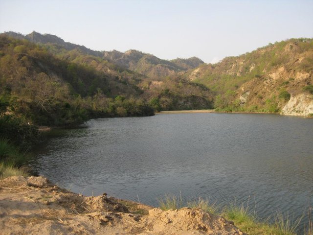
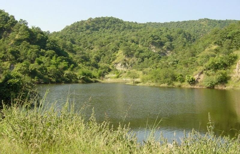
The second main objective is to provide supplementary irrigation water to the village below through construction of one, or more, earth dams. The village community - organised into a Hill Resource Management Society - is the source of highly subsidised labour for forest catchment treatment. After catchment protection around the proposed dam site(s), the dam(s) and pipeline(s) are constructed. The dams are generally between 20,000 and 200,000 m3 in capacity, and the pipelines usually one kilometre or less in length.
Apart from irrigation, the villagers benefit from communal use of non-timber forest resources. Forest catchment treatment (associated with the approach termed ‘joint forest management’ - JFM) has been developed from a pilot initiative in Sukhomajri village in 1976, and has spread very widely throughout India. This description focuses on Ambala and Yamunanagar Districts in Haryana State.
The Shiwalik hills where the SWC technology was applied is one of the eight most degraded, rainfed agro-ecosystems of India. It is highly erodible, with presence of low water retentive soils and severe soil erosion, haing water scarcity despite average 1000 mm annual rainfall.
2.3 รูปภาพของเทคโนโลยี
อัลบั้มสื่อบันทึก
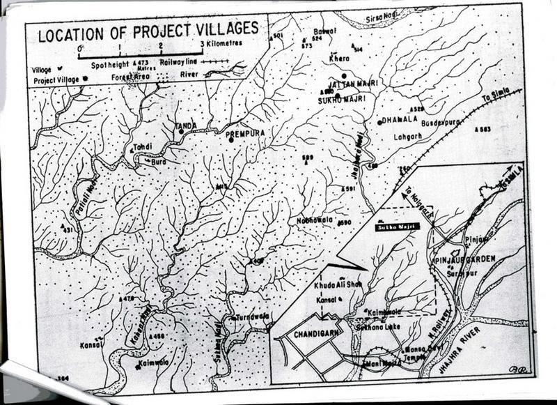
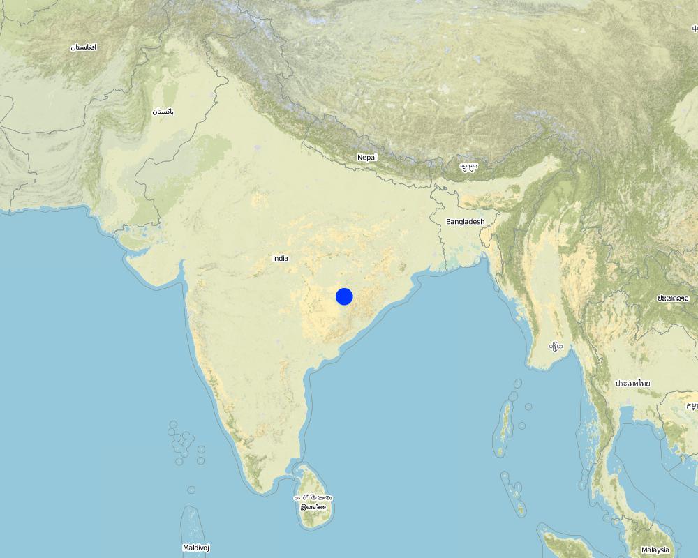
2.5 ประเทศภูมิภาค หรือสถานที่ตั้งที่เทคโนโลยีได้นำไปใช้และได้รับการครอบคลุมโดยการประเมินนี้
ประเทศ:
อินเดีย
ภูมิภาค/รัฐ/จังหวัด:
Haryana
ข้อมูลจำเพาะเพิ่มเติมของสถานที่ตั้ง :
Ambala and Yamunanagar
แสดงความคิดเห็น:
Total area covered by the SLM Technology is 198 km2.
Map
×3. การจัดประเภทของเทคโนโลยี SLM
3.1 วัตถุประสงค์หลักของเทคโนโลยี
- ปรับปรุงการผลิตให้ดีขึ้น
- ลด ป้องกัน ฟื้นฟู การเสื่อมโทรมของที่ดิน
3.2 ประเภทของการใช้ที่ดินในปัจจุบันที่ได้นำเทคโนโลยีไปใช้
Land use mixed within the same land unit:
ใช่
Specify mixed land use (crops/ grazing/ trees):
- ปศุสัตว์ร่วมกับการทำป่าไม้ (Silvo-pastoralism)

ทุ่งหญ้าเลี้ยงสัตว์

ป่า/พื้นที่ทำไม้
- Rehabilitated natural forest
Type of tree:
- Acacia species
- Dalbergia sissoo
แสดงความคิดเห็น:
Major land use problems (compiler’s opinion): The Shiwalik Hills are extremely prone to both surface erosion and landslides, and general degradation of vegetation due to over-exploitation. Some areas have become completely denuded because of overgrazing and woodcutting. Furthermore there is no, or inadequate, water for irrigation of crops.
Grazingland comments: Due to free grazing, much of the forest land was becoming barren and fodder yield declined over a period of time. The average fodder yield was about two quintals/ha of forest land and fodder consumption was 26.69kg/animal/day.
Problems / comments regarding forest use: Tree species like Khaci (Acacia catechu), Dalbergio sissoo in pits and slips of bhabbar grass (Eulaliopsis binata) on mounds of trenches and hill slopes were planted. Bhabbar grass was sold out by forest department to contractors.
Type of grazing system comments: Due to free grazing, much of the forest land was becoming barren and fodder yield declined over a period of time. The average fodder yield was about two quintals/ha of forest land and fodder consumption was 26.69kg/animal/day.
Longest growing period in days: 120 Longest growing period from month to month: Jul - Oct
3.5 กลุ่ม SLM ที่ตรงกับเทคโนโลยีนี้
- การปิดล้อมพื้นที่ (หยุดการใช้ประโยชน์ สนับสนุนการฟื้นฟู)
- การปรับปรุงดิน / พืชคลุมดิน
- มาตรการปลูกพืชขวางความลาดชัน (cross-slope measure)
3.6 มาตรการ SLM ที่ประกอบกันเป็นเทคโนโลยี

มาตรการอนุรักษ์ด้วยโครงสร้าง
แสดงความคิดเห็น:
Main measures: structural measures
Secondary measures: vegetative measures, management measures
3.7 รูปแบบหลักของการเสื่อมโทรมของที่ดินที่ได้รับการแก้ไขโดยเทคโนโลยี

การกัดกร่อนของดินโดยน้ำ
- Wt (Loss of topsoil): การสูญเสียดินชั้นบนหรือการกัดกร่อนที่ผิวดิน
- Wg (Gully erosion): การกัดกร่อนแบบร่องธารหรือการทำให้เกิดร่องน้ำเซาะ
- Wm (Mass movement): การเคลื่อนตัวของมวลดินหรือดินถล่ม

การเสื่อมโทรมของน้ำ
- Ha (Aridification): การเกิดความแห้งแล้ง
แสดงความคิดเห็น:
Main type of degradation addressed: Wt: loss of topsoil / surface erosion
Secondary types of degradation addressed: Wg: gully erosion / gullying, Wm: mass movements / landslides, Ha: aridification
Main causes of degradation: deforestation / removal of natural vegetation (incl. forest fires), education, access to knowledge and support services (Absence of institutional arrangements to disseminate the knowledge from lab to land and involve the users in implementation)
Secondary causes of degradation: overgrazing (Subsistence economy, dependance on forests for fuelwood and fodder, livestock were low quality, free grazing type. And these were no regulatory mechanisms to share usufruct from forests with people.), poverty / wealth (Lack of capital at the grassroot to take the initiative by the farmers themselves)
3.8 การป้องกัน การลดลง หรือการฟื้นฟูความเสื่อมโทรมของที่ดิน
ระบุเป้าหมายของเทคโนโลยีกับความเสื่อมโทรมของที่ดิน:
- ลดความเสื่อมโทรมของดิน
4. ข้อมูลจำเพาะด้านเทคนิค กิจกรรมการนำไปปฏิบัติใช้ ปัจจัยนำเข้า และค่าใช้จ่าย
4.1 แบบแปลนทางเทคนิคของเทคโนโลยี
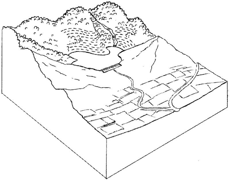
ข้อมูลจำเพาะด้านเทคนิค (แบบแปลนทางเทคนิคของเทคโนโลยี):
Forest catchment treatment: an overview showing protected forest, dam and irrigated cropland below.
Technical knowledge required for field staff / advisors: moderate
Technical knowledge required for land users: moderate
Main technical functions: increase of infiltration, water harvesting / increase water supply
Secondary technical functions: control of dispersed runoff: retain / trap, improvement of ground cover, control of concentrated runoff
Vegetative measure: enrichment planting with
Vegetative material: T : trees / shrubs, G : grass
Vegetative measure: Vegetative material: T : trees / shrubs, G : grass
Vegetative measure: Vegetative material: T : trees / shrubs, G : grass
Vegetative measure: Vegetative material: T : trees / shrubs, G : grass
Trees/ shrubs species: Acacia catechu, Dalbergia sissoo etc
Grass species: bhabbar grass: Eulaliopsis binata
Structural measure: dam
Structural measure: trenches
Structural measure: ditches
Structural measure: check dams
Other type of management: social fencing
ผู้เขียน:
Mats Gurtner
4.3 กิจกรรมเพื่อการจัดตั้ง
| กิจกรรม | Timing (season) | |
|---|---|---|
| 1. | Enrichment planting of tree seedlings (Acacia catechu, Dalbergiasissoo etc), grasses (bhabbar grass: Eulaliopsis binata) on bundsof earth and hill slopes, and Ipomea cornea in channels. | beginning of the monsoon rains. |
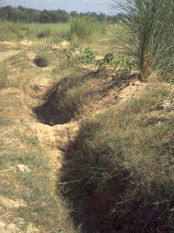
| 2. | Construction of a series of staggered contour trenches on slopes. | pre-monsoon |
| 3. | Construction of stone/earth/wood check dams in gullies. | pre-monsoon |
| 4. | Construction of graded stabilisation channels which capture runoffand discharge it safely. | pre-monsoon |
| 5. | Construction of earth dam wall for water harvesting and concretepipelines for irrigation. | pre-monsoon |
| 6. | Introduction of social fencing system through Hill ResourceManagement Societies. | pre-monsoon |
4.4 ค่าใช้จ่ายของปัจจัยนำเข้าที่จำเป็นสำหรับการจัดตั้ง
| ปัจจัยนำเข้า | หน่วย | ปริมาณ | ค่าใช้จ่ายต่อหน่วย | ค่าใช้จ่ายทั้งหมดต่อปัจจัยนำเข้า | %ของค่าใช้จ่ายที่ก่อให้เกิดขึ้นโดยผู้ใช้ที่ดิน | |
|---|---|---|---|---|---|---|
| แรงงาน | Labour | ha | 1.0 | 250.0 | 250.0 | 5.0 |
| อุปกรณ์ | Machine use | ha | 1.0 | 75.0 | 75.0 | |
| วัสดุด้านพืช | Seedlings | ha | 1.0 | 50.0 | 50.0 | |
| วัสดุสำหรับก่อสร้าง | Construction material for dam wall | ha | 1.0 | 25.0 | 25.0 | |
| ค่าใช้จ่ายทั้งหมดของการจัดตั้งเทคโนโลยี | 400.0 | |||||
| Total costs for establishment of the Technology in USD | 400.0 | |||||
แสดงความคิดเห็น:
Duration of establishment phase: 36 month(s)
4.5 การบำรุงรักษาสภาพหรือกิจกรรมที่เกิดขึ้นเป็นประจำ
| กิจกรรม | ช่วงระยะเวลา/ความถี่ | |
|---|---|---|
| 1. | watch and ward | /on-going |
| 2. | Desilting of water harvesting structures. | pre-monsoon,/once every year |
| 3. | Repair of channels. | pre-monsoon,/once every year |
| 4. | Maintenance of structures. | pre-monsoon,/ |
| 5. | regular meetings/facilitations | |
| 6. | control grazing fines, peer-group pressure |
4.6 ค่าใช้จ่ายของปัจจัยนำเข้าและกิจกรรมที่เกิดขึ้นเป็นประจำที่ต้องการการบำรุงรักษา (ต่อปี)
| ปัจจัยนำเข้า | หน่วย | ปริมาณ | ค่าใช้จ่ายต่อหน่วย | ค่าใช้จ่ายทั้งหมดต่อปัจจัยนำเข้า | %ของค่าใช้จ่ายที่ก่อให้เกิดขึ้นโดยผู้ใช้ที่ดิน | |
|---|---|---|---|---|---|---|
| แรงงาน | Labour | ha | 1.0 | 50.0 | 50.0 | 95.0 |
| ค่าใช้จ่ายทั้งหมดของการบำรุงรักษาสภาพเทคโนโลยี | 50.0 | |||||
| Total costs for maintenance of the Technology in USD | 50.0 | |||||
แสดงความคิดเห็น:
This information is indicative and is based on calculations derived from Thaska village (Yamunanagar District)
where there are 3 dams - collecting the runoff from the total forest catchment of 75 ha. The cost range of treatments per
hectare of rehabilitated forest is generally US$ 200–700 (where the main cost is that of the dam construction) and typically the area of supplementary irrigation (command area) is twice as large as the forest catchment treated (in this case the irrigated area is 150 ha).
Cost per unit: the treatment of a 25 ha unit of catchment including construction of a dam costs around US$ 10,000.
5. สิ่งแวดล้อมทางธรรมชาติและของมนุษย์
5.1 ภูมิอากาศ
ฝนประจำปี
- < 250 ม.ม.
- 251-500 ม.ม.
- 501-750 ม.ม.
- 751-1,000 ม.ม.
- 1,001-1,500 ม.ม.
- 1,501-2,000 ม.ม.
- 2,001-3,000 ม.ม.
- 3,001-4,000 ม.ม.
- > 4,000 ม.ม.
เขตภูมิอากาศเกษตร
- กึ่งชุ่มชื้น
- กึ่งแห้งแล้ง
Semi arid: Shiwalik region falls under semi-arid agro-climatic zone.
5.2 สภาพภูมิประเทศ
ค่าเฉลี่ยความลาดชัน:
- ราบเรียบ (0-2%)
- ลาดที่ไม่ชัน (3-5%)
- ปานกลาง (6-10%)
- เป็นลูกคลื่น (11-15%)
- เป็นเนิน (16-30%)
- ชัน (31-60%)
- ชันมาก (>60%)
ธรณีสัณฐาน:
- ที่ราบสูง/ที่ราบ
- สันเขา
- ไหล่เขา
- ไหล่เนินเขา
- ตีนเนิน
- หุบเขา
ระดับความสูง:
- 0-100 เมตร
- 101-500 เมตร
- 501-1,000 เมตร
- 1,001-1,500 เมตร
- 1,501-2,000 เมตร
- 2,001-2,500 เมตร
- 2,501-3,000 เมตร
- 3,001-4,000 เมตร
- > 4,000 เมตร
ความคิดเห็นและข้อมูลจำเพาะเพิ่มเติมเรื่องสภาพภูมิประเทศ:
Landforms: Hill slopes (ranked 1, Higher hills are located in the northern and eastern part of the tract, while low hills in the southern and western parts of the tract. These hills are characterized by relatively high intensity of er), ridges (ranked 2) and footslopes (ranked 3)
Slopes on average: Moderate (ranked 1, the slopes vary considerably from moderate to precipitous), hilly (ranked 2) and steep (ranked 3)
5.3 ดิน
ค่าเฉลี่ยความลึกของดิน:
- ตื้นมาก (0-20 ซ.ม.)
- ตื้น (21-50 ซ.ม.)
- ลึกปานกลาง (51-80 ซ.ม.)
- ลึก (81-120 ซ.ม.)
- ลึกมาก (>120 ซ.ม.)
เนื้อดิน (ดินชั้นบน):
- หยาบ/เบา (ดินทราย)
อินทรียวัตถุในดิน:
- ปานกลาง (1-3%)
- ต่ำ (<1%)
(ถ้ามี) ให้แนบคำอธิบายเรื่องดินแบบเต็มหรือระบุข้อมูลที่มีอยู่ เช่น ชนิดของดิน ค่า pH ของดินหรือความเป็นกรดของดิน ความสามารถในการแลกเปลี่ยนประจุบวก ไนโตรเจน ความเค็ม เป็นต้น:
Soil depth on average: Also shallow (ranked 2) and deep (ranked 3)
Soil texture: Coarse (ranked 1, in most of the areas soils are sandy. However sandy loam, loamy sand and sill loam soils are also met with), medium (ranked 2) and fine/heavy (ranked 3)
Soil fertility: Medium (soils are deficient in humus contents. However soils are fairly fertile and suitable for raising forest crops in the entire area)
Soil drainage/infiltration: Poor (water holding capacity of soils is good)
5.6 ลักษณะของผู้ใช้ที่ดินที่นำเทคโนโลยีไปปฏิบัติใช้
แนวทางการตลาดของระบบการผลิต:
- เพื่อการยังชีพ (หาเลี้ยงตนเอง)
- mixed (subsistence/ commercial)
รายได้ที่มาจากนอกฟาร์ม:
- 10-50% ของรายได้ทั้งหมด
ระบุลักษณะอื่นๆที่เกี่ยวข้องของผู้ใช้ที่ดิน:
Off-farm income specification: significant off-farm activity/income includes rope making from bhabbar grass. Sale of fodder grass from the forest provides
additional income.
Market orientation forest land: Mixed (forest dept. used to give annual contracts for bhabbar grasses)
5.7 Average area of land used by land users applying the Technology
- < 0.5 เฮกตาร์
- 0.5-1 เฮกตาร์
- 1-2 เฮกตาร์
- 2-5 เฮกตาร์
- 5-15 เฮกตาร์
- 15-50 เฮกตาร์
- 50-100 เฮกตาร์
- 100-500 เฮกตาร์
- 500-1,000 เฮกตาร์
- 1,000-10,000 เฮกตาร์
- >10,000 เฮกตาร์
แสดงความคิดเห็น:
2-5 ha: Grazing land mainly comprises of forest area where villagers have rights, private as well as community lands.
5.8 กรรมสิทธิ์ในที่ดิน สิทธิในการใช้ที่ดินและสิทธิในการใช้น้ำ
กรรมสิทธิ์ในที่ดิน:
- รัฐ
สิทธิในการใช้ที่ดิน:
- เกี่ยวกับชุมชน (ถูกจัดระเบียบ)
6. ผลกระทบและสรุปคำบอกกล่าว
6.1 ผลกระทบในพื้นที่ดำเนินการ (On-site) จากการใช้เทคโนโลยี
ผลกระทบทางด้านเศรษฐกิจและสังคม
การผลิต
การผลิตพืชที่ใช้เลี้ยงปศุสัตว์
คุณภาพพืชที่ใช้เลี้ยงปศุสัตว์
การผลิตไม้
ความหลากหลายของผลิตภัณฑ์
แสดงความคิดเห็น/ระบุ:
Increased non-timber forest products
รายได้และค่าใช้จ่าย
รายได้จากฟาร์ม
ความเหลื่อมล้ำทางเศรษฐกิจ
แสดงความคิดเห็น/ระบุ:
Those with irrigation vs those without
ผลกระทบด้านสังคมวัฒนธรรมอื่น ๆ
สถาบันของชุมชน
SLM หรือความรู้เรื่องความเสื่อมโทรมของที่ดิน
การบรรเทาความขัดแย้ง
แสดงความคิดเห็น/ระบุ:
Those with irrigation vs those without
ผลกระทบด้านนิเวศวิทยา
ดิน
ความชื้นในดิน
สิ่งปกคลุมดิน
การสูญเสียดิน
ความหลากหลายทางชีวภาพของพืชและสัตว์
การปกคลุมด้วยพืช
แสดงความคิดเห็น/ระบุ:
Trees and grass
ความหลากหลายทางชีวภาพของพืช
ความหลากหลายทางชีวภาพของสัตว์
ความหลากหลายของสัตว์
6.2 ผลกระทบนอกพื้นที่ดำเนินการ (Off-site) จากการใช้เทคโนโลยี
การไหลของน้ำคงที่และสม่ำเสมอในช่วงฤดูแล้ง
น้ำท่วมพื้นที่ท้ายน้ำ
การทับถมของดินตะกอนพื้นที่ท้ายน้ำ
Crop yield
แสดงความคิดเห็น/ระบุ:
From new irrigation water
6.4 การวิเคราะห์ค่าใช้จ่ายและผลประโยชน์ที่ได้รับ
ผลประโยชน์ที่ได้รับเปรียบเทียบกับค่าใช้จ่ายในการจัดตั้งเป็นอย่างไร (จากมุมมองของผู้ใช้ที่ดิน)
ผลตอบแทนระยะสั้น:
ด้านบวกอย่างมาก
ผลตอบแทนระยะยาว:
ด้านบวกอย่างมาก
ผลประโยชน์ที่ได้รับเปรียบเทียบกับค่าใช้จ่ายในการบำรุงรักษาหรือต้นทุนที่เกิดขึ้นซ้ำอีก เป็นอย่างไร (จากมุมมองของผู้ใช้ที่ดิน)
ผลตอบแทนระยะสั้น:
ด้านบวกอย่างมาก
ผลตอบแทนระยะยาว:
ด้านบวกอย่างมาก
6.5 การปรับตัวของเทคโนโลยี
Of all those who have adopted the Technology, how many did so spontaneously, i.e. without receiving any material incentives/ payments?
- 51-90%
แสดงความคิดเห็น:
40% of land user families have adopted the Technology with external material support
Comments on acceptance with external material support: estimates
60% of land user families have adopted the Technology without any external material support
There is a strong trend towards spontaneous adoption of the Technology
Comments on adoption trend: The spread of such forest treatment within Haryana (and outside) is happening steadily.
Farmers have levelled theor fields to await water for irrigation from dams. The villagers have also contributed by money/labour in lying pipelines for water distribution.
6.7 จุดแข็ง / ข้อได้เปรียบ / โอกาสของเทคโนโลยี
| จุดแข็ง / ข้อได้เปรียบ / โอกาสในทัศนคติของผู้ใช้ที่ดิน |
|---|
|
Increased availabilzy of fodder and fuel. How can they be sustained / enhanced? Improvement in livestock mix and breed owned by villlagers. |
|
Increased crop yields, milk production and horticultural products How can they be sustained / enhanced? Suitable crop mix to derive maximum benefits from water from dams |
| จุดแข็ง / ข้อได้เปรียบ / โอกาสในทัศนคติของผู้รวบรวมหรือวิทยากรหลัก |
|---|
|
Increased surface and groundwater help to fill the dam rather than running off and causing flooding and erosion lower down (but not always: see first off-site disadvantage) How can they be sustained / enhanced? Ensure continuous protection/ regular maintenance. |
|
Increased fodder and fuel from the renewed forest resources How can they be sustained / enhanced? Ditto. |
|
Reduction of runoff and erosion in the previously degraded catchment How can they be sustained / enhanced? Ditto. |
|
Improved forest conditions – both canopy and understorey delivering general ecosystem benefits How can they be sustained / enhanced? Ditto. |
|
Increased crop yield from irrigation made possible through irrigation from the dam Increased household income Increased community institution strength How can they be sustained / enhanced? Ditto. |
6.8 จุดอ่อน / ข้อเสียเปรียบ / ความเสี่ยงของเทคโนโลยีและวิธีการแก้ไข
| จุดอ่อน / ข้อเสียเปรียบ / ความเสี่ยงในทัศนคติของผู้ใช้ที่ดิน | มีวิธีการแก้ไขได้อย่างไร |
|---|---|
| Initial investment to change the cattle mix. | Arrangement of credit facility. |
| จุดอ่อน / ข้อเสียเปรียบ / ความเสี่ยงในทัศนคติของผู้รวบรวมหรือวิทยากรหลัก | มีวิธีการแก้ไขได้อย่างไร |
|---|---|
| In some cases reduction in runoff (because of increased vegetation) causes less water for irrigation | Manipulate vegetative cover as required (selective cutting). |
| Conflicts in water distribution | Conflict resolution may need to be carried out through Hill Resource Management Societies. |
| High labour input. | |
| Regular maintenance and desilting of earthen dams. |
7. การอ้างอิงและการเชื่อมต่อ
7.1 วิธีการและแหล่งข้อมูล
7.2 การอ้างอิงถึงสิ่งตีพิมพ์
หัวข้อ, ผู้เขียน, ปี, หมายเลข ISBN:
Singh TP and Varalakshmi V: The Decade and Beyond: Evolving community-state partnership. TERI, New Delhi. 1998.
หัวข้อ, ผู้เขียน, ปี, หมายเลข ISBN:
Poffenberger M and McGean B (eds): Village Voices, Forest Choices. Joint Forest Management in India. Oxford University Press, Delhi. 1996.
ลิงก์และโมดูล
ขยายทั้งหมด ย่อทั้งหมดลิงก์
Joint forest management [อินเดีย]
Government and NGO supported community protection of forested catchments, through village-based Hill Resource Management Societies.
- ผู้รวบรวม: Sumana Datta
Joint forest management [อินเดีย]
Joint forest management is a community based program developed in collaboration with the forest department for the protection and management of local forests while providing incentives to the local communities with political and institutional support from the state.
- ผู้รวบรวม: Sumana Datta
โมดูล
ไม่มีโมดูล