Dedha grazing system as a natural resource management technology [Kenya]
- Création :
- Mise à jour :
- Compilateur : IBRAHIM JARSO
- Rédacteur : –
- Examinateur : Rima Mekdaschi Studer
Jars Dedha
technologies_3403 - Kenya
- Résumé complet en PDF
- Résumé complet en PDF pour impression
- Résumé complet dans le navigateur
- Résumé complet (non formaté)
- Système de pâturage «dedha», comme technologie de gestion des ressources naturelles: 12 juillet 2018 (inactive)
- Système de pâturage «dedha», comme technologie de gestion des ressources naturelles: 8 mai 2019 (inactive)
- Système de pâturage «dedha», comme technologie de gestion des ressources naturelles: 31 juillet 2018 (inactive)
- Système de pâturage «dedha», comme technologie de gestion des ressources naturelles: 3 septembre 2018 (inactive)
- Dedha grazing system as a natural resource management technology : 13 mai 2018 (inactive)
- Système de pâturage «dedha», comme technologie de gestion des ressources naturelles: 2 novembre 2021 (inactive)
- Système de pâturage «dedha», comme technologie de gestion des ressources naturelles: 2 novembre 2021 (public)
- Dedha grazing system as a natural resource management technology : 27 avril 2018 (inactive)
- Dedha grazing system as a natural resource management technology : 27 avril 2018 (inactive)
- Dedha grazing system as a natural resource management technology : 20 avril 2018 (inactive)
- Dedha grazing system as a natural resource management technology : 19 mars 2018 (inactive)
Voir les sections
Développer tout Réduire tout1. Informations générales
1.2 Coordonnées des personnes-ressources et des institutions impliquées dans l'évaluation et la documentation de la Technologie
Personne(s)-ressource(s) clé(s)
Spécialiste GDT:
Nom du projet qui a facilité la documentation/ l'évaluation de la Technologie (si pertinent)
Strengthening Adaptation and Resilience to Climate Change in Kenya Plus (StARCK+)Nom du ou des institutions qui ont facilité la documentation/ l'évaluation de la Technologie (si pertinent)
Resource Advocacy Programme (RAP) - Kenya1.3 Conditions relatives à l'utilisation par WOCAT des données documentées
Quand les données ont-elles été compilées (sur le terrain)?
17/11/2017
Le compilateur et la(les) personne(s) ressource(s) acceptent les conditions relatives à l'utilisation par WOCAT des données documentées:
Oui
1.4 Déclaration sur la durabilité de la Technologie décrite
Est-ce que la Technologie décrite ici pose problème par rapport à la dégradation des terres, de telle sorte qu'elle ne peut pas être déclarée comme étant une technologie de gestion durable des terres?
Non
Commentaires:
The technology is a sustainable land management practice that had been used for time immemorial by Boran pastoralists to manage land and land-based resources.
1.5 Référence au(x) questionnaire(s) sur les Approches de GDT
2. Description de la Technologie de GDT
2.1 Courte description de la Technologie
Définition de la Technologie:
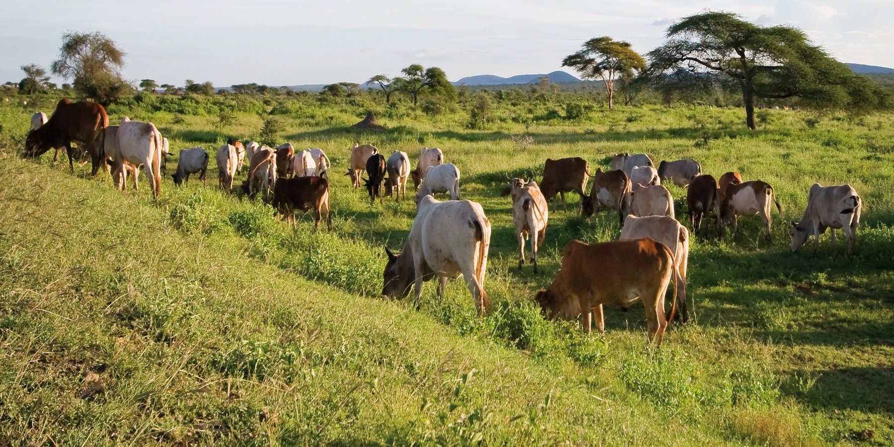
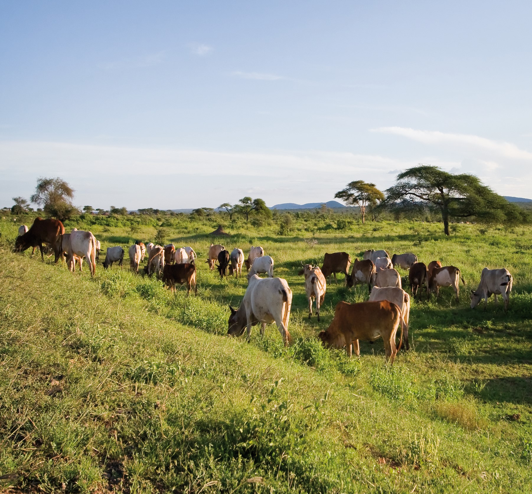
The Dedha grazing system is an ancient, traditional governance system for land and its resources practiced by Boran pastoralists. It carefully balances how pastoralists use rangeland resources. The basis of the technology is three grazing rangeland governance zones: wet season grazing, dry season grazing, and drought reserves. There is also water governance based on a traditional hierarchy of rights. Through this system, Boran pastoralists adapt to severe and recurrent droughts.
2.2 Description détaillée de la Technologie
Description:
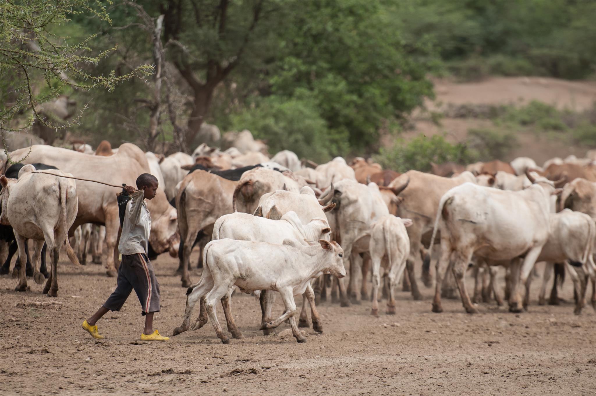
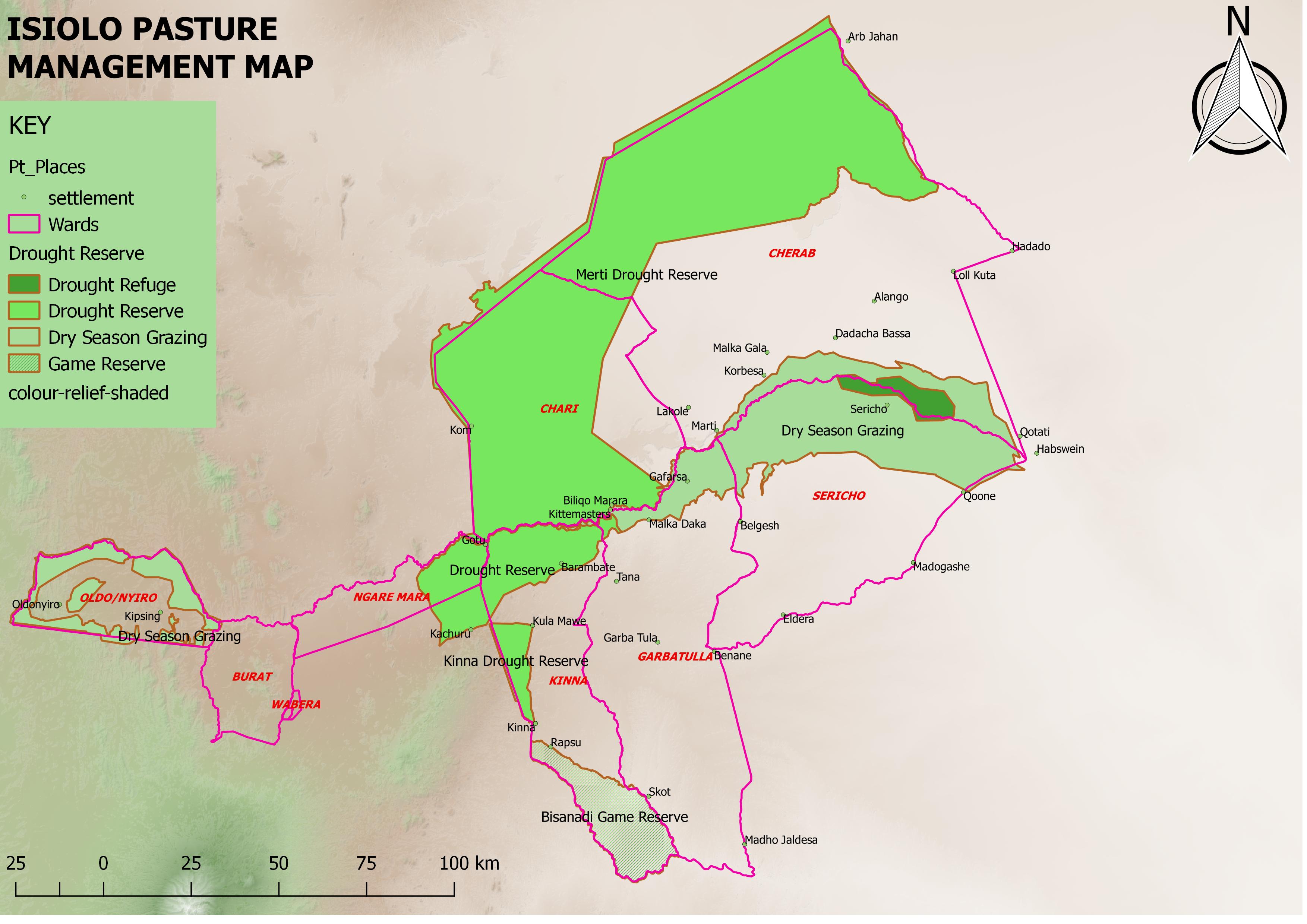
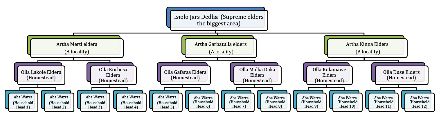
This grazing system is applied in Isiolo County, Northern Kenya. The Waso rangelands are inhabited by Boran pastoralists with Somali, Samburu, Rendille and Turkana herders sharing cross-border resources through negotiation. The technology is based on the maintenance of a delicate balance between livestock numbers, the supply of water, and the amount/ quality of standing pasture within the vast grazing area which is water scarce and prone to extreme seasonal variations. Through its main tenet of governing grazing patterns (wet, dry season grazing area and drought reserve) planned use of pasture is decided in large pastoralists’ assemblies attended by elders from a particular “Dedha” (a grazing area, which administratively can be as big as two wards). This process is complicated by dry seasons and droughts of unknown length, with pressure from the community to open grazing reserves. Wrong decisions can spell the end of livelihoods for some families. An ability, which has been gradually eroded over time and by external factors which don’t understand its enormous benefit but there is a project which is using an integrated approach to revive and empower this system.
The Jars a Dedha use water points to manage grazing. Different types of water sources need specific forms of management. The most intensive management occurs during droughts at deep wells and boreholes which require the most labour to operate and maintain, and are the most reliable sources of water. Due to the strategic importance of these resources, management falls to the Jarsa Dedha (council of elders). The use of shallow wells is tightly controlled by both the aba ella (the person who first dug it) and aba erega (the owner of the rotter ) working together. Aba ella is assigned first rights to water. If there is spare capacity then ‘second rights’ are decided by aba erega. Second rights would typically fall to those of a different clan, while ‘third rights’ might fall to a different ethnic group. The Borana customs and culture defines both access to certain wells but also the order of priority for watering animals.
In addition, in consultation with the Dedha council of elders, aba erega manages the use of dams and access to rivers. Generally, use of flowing river water is restricted to the dry season and access is limited to designated watering points. These are located some distance downriver from settlements to minimize disruption to inhabitants and to reduce contamination. Temporary water sources during and after the rains are not subject to control except when their use conflicts with restrictions on grazing areas. After watering their livestock, pastoralists traditionally fill their troughs for wildlife at night. This is intended to prevent wildlife from falling into wells - and to seek God’s blessings.
The high variability of rainfall in pastoral areas leads to similarly variable pasture availability. Therefore, management of grazing resources needs to balance maximizing productivity while ensuring survival. Long-term viability of the system depends on the maintenance of adaptive traits within local breeds, and both maintaining and managing resources strategically. Only within these broader goals is the concept of ‘maximizing productivity’ meaningful.
Mature livestock (gues) which are not lactating are moved to remote pastures. The gues, which make up the majority of community livestock, are herded by young unmarried men. By utilizing remote pastures, grazing resources closer to permanent water sources can be preserved for the dry season and droughts. Pasture within the vicinity of homesteads (maar qaae – literally ‘near grass’) is protected from grazing by non-lactating livestock (this is similar to kalo but a kalo reserve need not be next to the homestead ). This pasture is set aside for young animals (calves, lambs, and kids). Migrating livestock have predefined routes that maintain distance from maar qaae. The Dedha council of elders, therefore, controls settlement patterns to preserve key migratory routes. Movement of livestock between different Dedhas must be prearranged with the respective Dedha council of elders who assess spare capacity in terms of water and grazing.
The floodplain grazing area (chaafa) is crucial because it acts as a refuge for livestock during extreme drought. Grazing in chaafa is strictly prohibited during the wet season and one of the critical decisions for the Jarsa Dedha is when to open chaafa after rains have failed. Due to the relatively moist conditions in chaafa, there are additional challenges to animal and human health: namely trypanosomiasis, ticks, pneumonia, and malaria. Jarsa Dedha make decisions primarily concerning seasonal movements from wet to dry season grazing and also the opening of boreholes and chaafa. The overwhelming local consensus is that efficient resource use depends on the ability ofJarsa Dedha to enforce these regulations
2.3 Photos de la Technologie
Galerie Médias
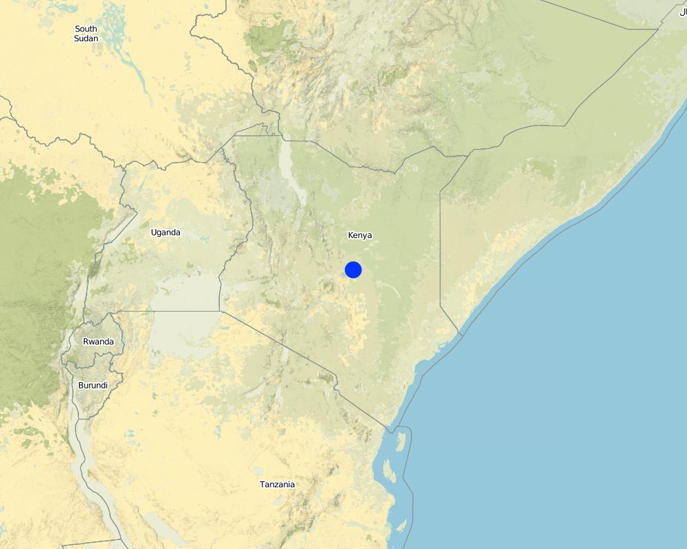
2.5 Pays/ région/ lieux où la Technologie a été appliquée et qui sont couverts par cette évaluation
Pays:
Kenya
Région/ Etat/ Province:
Isiolo
Autres spécifications du lieu:
Kinna town, Kinna Ward, isiolo County
Commentaires:
Kinna Town, Kinna Ward, Garbatulla Sub County, Isiolo County
Map
×2.6 Date de mise en œuvre de la Technologie
Si l'année précise est inconnue, indiquez la date approximative: :
- il y a plus de 50 ans (technologie traditionnelle)
2.7 Introduction de la Technologie
Spécifiez comment la Technologie a été introduite: :
- dans le cadre d'un système traditionnel (> 50 ans)
Commentaires (type de projet, etc.) :
It is inherited from generations before.
3. Classification de la Technologie de GDT
3.1 Principal(aux) objectif(s) de la Technologie
- réduire, prévenir, restaurer les terres dégradées
- préserver l'écosystème
- protéger un bassin versant/ des zones situées en aval - en combinaison avec d'autres technologies
- conserver/ améliorer la biodiversité
- réduire les risques de catastrophes
- s'adapter au changement et aux extrêmes climatiques et à leurs impacts
- atténuer le changement climatique et ses impacts
- créer un impact économique positif
- créer un impact social positif
3.2 Type(s) actuel(s) d'utilisation des terres, là où la Technologie est appliquée

Pâturages
Pâturage extensif:
- Nomadisme
- Semi-nomadisme/ pastoralisme
Pâturage intensif/ production fourragère :
- Prairies améliorées
3.3 Informations complémentaires sur l'utilisation des terres
Approvisionnement en eau des terres sur lesquelles est appliquée la Technologie:
- pluvial
Commentaires:
The pastoralists depend on attendant pasture after the rains which are bi-modal in Isiolo County (Long and Short rains).
Nombre de période de croissance par an: :
- 2
Précisez:
Grasses and shrubs which nourishes livestock grows during the rainy seasons
Densité d'élevage/ chargement (si pertinent):
Isiolo county is endowed with a substantial livestock resource base that includes 198,500 cattle, 399,000 goats, 361,900 sheep and 39,100 camels
3.4 Groupe de GDT auquel appartient la Technologie
- pastoralisme et gestion des pâturages
3.5 Diffusion de la Technologie
Spécifiez la diffusion de la Technologie:
- répartie uniformément sur une zone
Si la Technologie est uniformément répartie sur une zone, indiquez la superficie couverte approximative:
- > 10 000 km2
Commentaires:
Isiolo County has area of 25,000Km2 but 80% of the area is used for Nomadic pastoralism.
3.6 Mesures de GDT constituant la Technologie

modes de gestion
- M2: Changement du niveau de gestion / d'intensification
- M3: Disposition/plan en fonction de l'environnement naturel et humain
- M4: Changement majeur dans le calendrier des activités
3.7 Principaux types de dégradation des terres traités par la Technologie

dégradation biologique
- Bc: réduction de la couverture végétale
- Bh: perte d’habitats
- Bf: effets néfastes des feux
- Bs: baisse de la qualité et de la composition/ diversité des espèces

dégradation hydrique
- Ha: aridification
- Hs: changement de la quantité d’eau de surface
- Hp: baisse de la qualité des eaux de surface
- Hw: réduction de la capacité tampon des zones humides
3.8 Prévention, réduction de la dégradation ou réhabilitation des terres dégradées
Spécifiez l'objectif de la Technologie au regard de la dégradation des terres:
- prévenir la dégradation des terres
- s'adapter à la dégradation des terres
4. Spécifications techniques, activités, intrants et coûts de mise en œuvre
4.1 Dessin technique de la Technologie
Auteur:
Ibrahim Jarso
Date:
02/05/2017
Auteur:
Ibrahim Jarso
Date:
06/03/2017
4.2 Spécification/ explications techniques du dessin technique
The technology is implemented in a vast area of rangelands in Isiolo County which covers around 20,000 km2 inhabited by Boran pastoralists under common management of Isiolo Jars Dedha (Council of elders). The rangelands are subdivided into around 14 arthas (localities) which are separately managed by artha elders and within which there are also ollas (homesteads) which the elders oversee. The elders manage key resources that are essential for pastoral livelihood. The resources are; prime pasture/grazing areas, water points e.g. streams, rivers, springs, shallow wells and pans, wildlife, forests, minerals, sand and other valuable stones e.g. gemstones (bojimine) and quarry, Trees and their products e.g. makuti, medicinal herbs, wild, fruits, resins, gum arabic.
4.3 Informations générales sur le calcul des intrants et des coûts
Spécifiez la manière dont les coûts et les intrants ont été calculés:
- par superficie de la Technologie
Indiquez la taille et l'unité de surface:
20,000km2
Indiquez le coût salarial moyen de la main d'œuvre par jour:
2,500 Kenya Shillings
4.4 Activités de mise en place/ d'établissement
| Activité | Type de mesures | Calendrier | |
|---|---|---|---|
| 1. | Dedha elders meetings | Modes de gestion | All seasons |
| 2. | Surveillance of grazing areas | Modes de gestion | Largely after the rains |
| 3. | Settling resource based disputes | Modes de gestion | Largely during dry seasons and drought |
| 4. | Deciding on when to access reserved pasture lands | Végétale | Dry seasons and drought reserves |
| 5. | Negotiations on access to pasture within and across borders | Végétale | Drought and Long dry seasons |
Commentaires:
Regarding Surveillance of grazing areas, they observe pasture conditions and unwarranted access to preserved grazing areas and report on conditions. The surveillance is elevated after the rains as communities are in wet season grazing area depending on sub-surface water from the rains.
4.6 Activités d'entretien/ récurrentes
| Activité | Type de mesures | Calendrier/ fréquence | |
|---|---|---|---|
| 1. | Meetings | Modes de gestion | All seasons |
| 2. | Surveillance of grazing lands | Modes de gestion | After the two rainy seasons |
4.8 Facteurs les plus importants affectant les coûts
Décrivez les facteurs les plus importants affectant les coûts :
This is a traditional technology of governing rangelands which was started and done voluntarily by the pastoralists. The costs considered are for subsistence of elders undertaking the meetings and discussions on range governance but the process still goes on even without the financial support as the actors involved do it for their own benefits.
5. Environnement naturel et humain
5.1 Climat
Précipitations annuelles
- < 250 mm
- 251-500 mm
- 501-750 mm
- 751-1000 mm
- 1001-1500 mm
- 1501-2000 mm
- 2001-3000 mm
- 3001-4000 mm
- > 4000 mm
Spécifications/ commentaires sur les précipitations:
The rains are bimodal (Long rains of March-April-May and Short rains of October-November-December). The rains are unpredictable, erratic and not evenly distributed but pastoralists move to take advantage of difference in pasture quality and quantity.
Indiquez le nom de la station météorologique de référence considérée:
Garbatulla automatic weather station
Zone agro-climatique
- semi-aride
- aride
5% of the area is Semi-arid and 95% is Arid.
5.2 Topographie
Pentes moyennes:
- plat (0-2 %)
- faible (3-5%)
- modéré (6-10%)
- onduleux (11-15%)
- vallonné (16-30%)
- raide (31-60%)
- très raide (>60%)
Reliefs:
- plateaux/ plaines
- crêtes
- flancs/ pentes de montagne
- flancs/ pentes de colline
- piémonts/ glacis (bas de pente)
- fonds de vallée/bas-fonds
Zones altitudinales:
- 0-100 m
- 101-500 m
- 501-1000 m
- 1001-1500 m
- 1501-2000 m
- 2001-2500 m
- 2501-3000 m
- 3001-4000 m
- > 4000 m
Indiquez si la Technologie est spécifiquement appliquée dans des:
- non pertinent
5.3 Sols
Profondeur moyenne du sol:
- très superficiel (0-20 cm)
- superficiel (21-50 cm)
- modérément profond (51-80 cm)
- profond (81-120 cm)
- très profond (>120 cm)
Texture du sol (de la couche arable):
- grossier/ léger (sablonneux)
- moyen (limoneux)
Texture du sol (> 20 cm sous la surface):
- grossier/ léger (sablonneux)
- moyen (limoneux)
Matière organique de la couche arable:
- moyen (1-3%)
5.4 Disponibilité et qualité de l'eau
Profondeur estimée de l’eau dans le sol:
> 50 m
Disponibilité de l’eau de surface:
moyenne
Qualité de l’eau (non traitée):
eau potable
La salinité de l'eau est-elle un problème? :
Oui
Précisez:
Many boreholes dug in the area is saline
La zone est-elle inondée?
Oui
Régularité:
épisodiquement
Commentaires et précisions supplémentaires sur la qualité et la quantité d'eau:
The Ewaso Nyiro River floods every rainy seasons
5.5 Biodiversité
Diversité des espèces:
- moyenne
Diversité des habitats:
- moyenne
5.6 Caractéristiques des exploitants des terres appliquant la Technologie
Sédentaire ou nomade:
- Semi-nomade
- Nomade
Orientation du système de production:
- subsistance (auto-approvisionnement)
Revenus hors exploitation:
- moins de 10% de tous les revenus
Niveau relatif de richesse:
- très pauvre
- pauvre
Individus ou groupes:
- individu/ ménage
- groupe/ communauté
Niveau de mécanisation:
- travail manuel
- traction animale
Genre:
- hommes
Age des exploitants des terres:
- jeunes
- personnes d'âge moyen
5.7 Superficie moyenne des terres détenues ou louées par les exploitants appliquant la Technologie
- < 0,5 ha
- 0,5-1 ha
- 1-2 ha
- 2-5 ha
- 5-15 ha
- 15-50 ha
- 50-100 ha
- 100-500 ha
- 500-1 000 ha
- 1 000-10 000 ha
- > 10 000 ha
Cette superficie est-elle considérée comme de petite, moyenne ou grande dimension (en se référant au contexte local)?
- grande dimension
5.8 Propriété foncière, droits d’utilisation des terres et de l'eau
Propriété foncière:
- communauté/ village
Droits d’utilisation des terres:
- communautaire (organisé)
Droits d’utilisation de l’eau:
- communautaire (organisé)
5.9 Accès aux services et aux infrastructures
santé:
- pauvre
- modéré
- bonne
éducation:
- pauvre
- modéré
- bonne
assistance technique:
- pauvre
- modéré
- bonne
emploi (par ex. hors exploitation):
- pauvre
- modéré
- bonne
marchés:
- pauvre
- modéré
- bonne
énergie:
- pauvre
- modéré
- bonne
routes et transports:
- pauvre
- modéré
- bonne
eau potable et assainissement:
- pauvre
- modéré
- bonne
services financiers:
- pauvre
- modéré
- bonne
6. Impacts et conclusions
6.1 Impacts sur site que la Technologie a montrés
Impacts socio-économiques
Production
production animale
Quantité avant la GDT:
0
Quantité après la GDT:
2
Commentaires/ spécifiez:
The frequent and Severe drought has reduced the number of livestock and created a big group of pastoral dropouts but with improved rangeland management through the revived traditional systems animal production is gradually improving.
gestion des terres
Quantité avant la GDT:
0
Quantité après la GDT:
2
Disponibilité et qualité de l'eau
disponibilité de l'eau potable
Quantité avant la GDT:
0
Quantité après la GDT:
1
disponibilité de l'eau pour l'élevage
Quantité avant la GDT:
0
Quantité après la GDT:
2
Impacts écologiques
Cycle de l'eau/ ruissellement
quantité d'eau
Quantité avant la GDT:
0
Quantité après la GDT:
2
récolte/ collecte de l'eau
Quantité avant la GDT:
0
Quantité après la GDT:
2
Biodiversité: végétale, animale
Couverture végétale
Quantité avant la GDT:
0
Quantité après la GDT:
2
espèces étrangères envahissantes
Quantité avant la GDT:
0
Quantité après la GDT:
1
diversité des habitats
Quantité avant la GDT:
0
Quantité après la GDT:
2
Réduction des risques de catastrophe et des risques climatiques
impacts de la sécheresse
Quantité avant la GDT:
-2
Quantité après la GDT:
2
microclimat
Quantité avant la GDT:
0
Quantité après la GDT:
2
6.2 Impacts hors site que la Technologie a montrés
disponibilité de l'eau
Quantité avant la GDT:
0
Quantité après la GDT:
2
Commentaires/ spécifiez:
The preserved grazing lands regenerate and is less degraded. The improved environment in the preserved areas lead to less erosion and proper recharge of underground water. This was observed in Kinna Village where the Odha Springs improved its flow and also the recharge to Moliti shallow wells were improved with proper grazing management in Kinna.
flux des cours d'eau fiables et stables en saison sèche
Quantité avant la GDT:
0
Quantité après la GDT:
2
6.3 Exposition et sensibilité de la Technologie aux changements progressifs et aux évènements extrêmes/catastrophes liés au climat (telles que perçues par les exploitants des terres)
Changements climatiques progressifs
Changements climatiques progressifs
| Saison | Type de changements/ extrêmes climatiques | Comment la Technologie fait-elle face à cela? | |
|---|---|---|---|
| températures saisonnières | saison sèche | augmente | très bien |
| précipitations saisonnières | saison sèche | décroît | très bien |
Extrêmes climatiques (catastrophes)
Catastrophes climatiques
| Comment la Technologie fait-elle face à cela? | |
|---|---|
| sécheresse | très bien |
| feu de végétation | bien |
Catastrophes hydrologiques
| Comment la Technologie fait-elle face à cela? | |
|---|---|
| inondation générale (rivière) | bien |
| crue éclair | modérément |
Catastrophes biologiques
| Comment la Technologie fait-elle face à cela? | |
|---|---|
| maladies épidémiques | modérément |
Autres conséquences liées au climat
Autres conséquences liées au climat
| Comment la Technologie fait-elle face à cela? | |
|---|---|
| réduction de la période de croissance | très bien |
6.4 Analyse coûts-bénéfices
Quels sont les bénéfices comparativement aux coûts de mise en place (du point de vue des exploitants des terres)?
Rentabilité à court terme:
légèrement positive
Rentabilité à long terme:
positive
Quels sont les bénéfices comparativement aux coûts d'entretien récurrents (du point de vue des exploitants des terres)?
Rentabilité à court terme:
légèrement positive
Rentabilité à long terme:
légèrement positive
6.5 Adoption de la Technologie
- plus de 50%
Si disponible, quantifiez (nombre de ménages et/ou superficie couverte):
80% of Isiolo County (Around 24,500 Households)
Parmi tous ceux qui ont adopté la Technologie, combien d'entre eux l'ont fait spontanément, à savoir sans recevoir aucune incitation matérielle ou aucun paiement?
- 90-100%
6.6 Adaptation
La Technologie a-t-elle été récemment modifiée pour s'adapter à l'évolution des conditions?
Oui
Si oui, indiquez à quel changement la Technologie s'est adaptée:
- changements/ extrêmes climatiques
Spécifiez l'adaptation de la Technologie (conception, matériaux/ espèces, etc.):
The grazing patterns were made more flexible and the rules made stricter.
6.7 Points forts/ avantages/ possibilités de la Technologie
| Points forts/ avantages/ possibilités du point de vue de l'exploitant des terres |
|---|
| It is the cheapest and easiest way of managing the rangelands for now and for posterity. |
| It provides room for flexibility of decision making as seasonal variations occur. |
| Points forts/ avantages/ possibilités du point de vue du compilateur ou d'une autre personne ressource clé |
|---|
| It is conservative and less costly to implement in the vast rangelands with few incentives. |
| It is a legitimate system recognized by all pastoralist for management of their rangeland resources. |
| It can easily be adapted to govern any pastoral rangelands all over the world (Universal). |
6.8 Faiblesses/ inconvénients/ risques de la Technologie et moyens de les surmonter
| Faiblesses/ inconvénients/ risques du point de vue de l’exploitant des terres | Comment peuvent-ils être surmontés? |
|---|---|
| There is no law protecting it. | Government needs to establish a law that recognizes and protects this technology. |
| Rich pastoralists can forego local rules and corrupt the systems overseeing the grazing plans. | Ensuring accountability for decisions made. As few lead elders can be corrupted and their decisions compromised but when the decisions on grazing are largely made in common meetings of all elders, the decisions are normally watertight and cant be influenced negatively. |
| Faiblesses/ inconvénients/ risques du point de vue du compilateur ou d'une autre personne ressource clé | Comment peuvent-ils être surmontés? |
|---|---|
| Cross-border pastoralists are not aware of the Technology and tend to undermine it. | Improve awareness of the technology among the cross-border pastoralists that also access Isiolo rangelands. |
7. Références et liens
7.1 Méthodes/ sources d'information
- visites de terrain, enquêtes sur le terrain
2
- interviews/entretiens avec les exploitants des terres
6
- compilation à partir de rapports et d'autres documents existants
2
7.3 Liens vers les informations pertinentes disponibles en ligne
Titre/ description:
Evolving customary institutions by patison and tari
URL:
pubs.iied.org/pdfs/10076IIED.pdf
Titre/ description:
Strengthening Customary institutions the case of Isiolo County Northern Kenya by Caroline, Tari and Jarso
URL:
www.celep.info/wp-content/uploads/2015/11/Strengthening-local-institutions.pdf
Liens et modules
Développer tout Réduire toutLiens
Aucun lien
Modules
Aucun module trouvé