Indigenous water collecting pond and livestock watering trough [Tanzanie]
- Création :
- Mise à jour :
- Compilateur : ALLAN BUBELWA
- Rédacteur : –
- Examinateurs : Donia Mühlematter, Fabian Ottiger, Alexandra Gavilano
elyeshero ne elyato (Haya tribe)
technologies_1157 - Tanzanie
- Résumé complet en PDF
- Résumé complet en PDF pour impression
- Résumé complet dans le navigateur
- Résumé complet (non formaté)
- Indigenous water collecting pond and livestock watering trough: 29 décembre 2016 (inactive)
- Indigenous water collecting pond and livestock watering trough: 5 juin 2017 (inactive)
- Indigenous water collecting pond and livestock watering trough: 28 juin 2018 (inactive)
- Indigenous water collecting pond and livestock watering trough: 6 août 2019 (public)
Voir les sections
Développer tout Réduire tout1. Informations générales
1.2 Coordonnées des personnes-ressources et des institutions impliquées dans l'évaluation et la documentation de la Technologie
Personne(s)-ressource(s) clé(s)
government:
Kagaruki Annagrace
Misseny District Council
Spécialiste GDT:
government:
Nom du ou des institutions qui ont facilité la documentation/ l'évaluation de la Technologie (si pertinent)
Missenyi District Council (Missenyi District Council) - TanzanieNom du ou des institutions qui ont facilité la documentation/ l'évaluation de la Technologie (si pertinent)
Food and Agriculture Organization of the United Nations (FAO) - Italie1.3 Conditions relatives à l'utilisation par WOCAT des données documentées
Le compilateur et la(les) personne(s) ressource(s) acceptent les conditions relatives à l'utilisation par WOCAT des données documentées:
Oui
2. Description de la Technologie de GDT
2.1 Courte description de la Technologie
Définition de la Technologie:
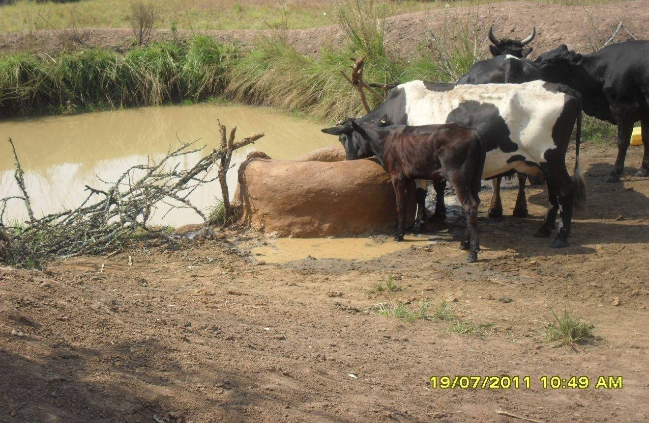
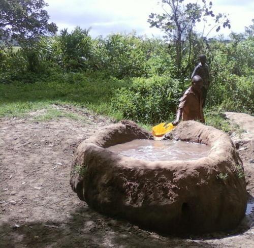
Construction of indigenous water pond and a livestock watering trough along an underground water source.
2.2 Description détaillée de la Technologie
Description:
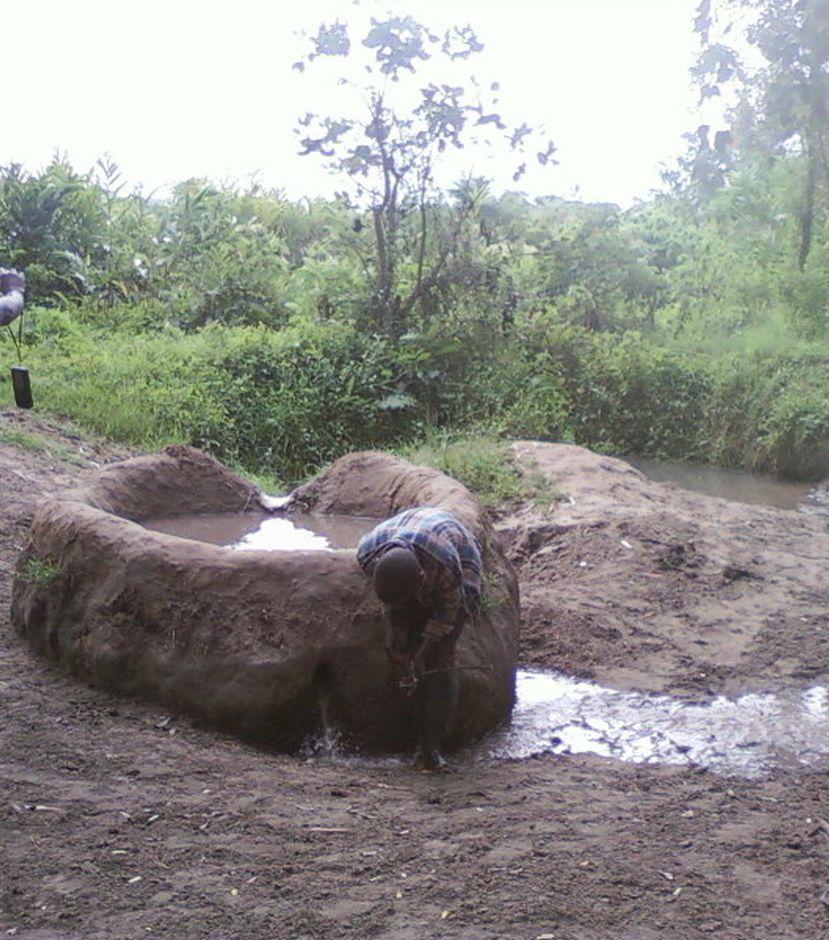
This technology is used during the dry seasons and where ground water level is high and there is natural water stream flowing from underground water source. Water pond is excavated along the naturally flowing water stream and is recharged by natural ground water. The size of the pond will vary depending on the area available, groundwater table, slope and soil characteristic. Groundwater collection ponds described in this technology on average are 4m long, 3m wide and 1m deep of 12m3 (12 000 liter) capacity and the slope is moderate 5% to 8% and soil characteristics is clay loam with deep soil. Water troughs (Elyato by local name) are constructed adjacent to the water pond to allow livestock to access clean drinking water. The number of troughs per pond is usually 1 to 2. Materials used in construction of water trough include clay, red termite mound soil, grass and wooden poles. The number of ponds needed usually depends on the expected number of animals and are arranged at irregular intervals ranging from 10 to 20 meters apart. The average size of a water trough is 0.14 m3 and can cater for 5 cattle at a time. The Pond is stabilized by naturally growing grass on its banks. Common pond stabilizer species are Leodicatiar digitalia and Hyperrhenia rufa. Management of the natural water source is through preventive village/customary by-laws which prohibit tree and grass cutting around the water source. The dominant indicator tree species normally found are Erythrina abysinica, Ficus thorgii and Phoenix recrinata. The animal watering troughs are usually used in the dry period. Before watering the troughs are coated (smeared) with red termite mound soil (normally hand carried by herders) to provide a good taste which is attractive to animals. Water is transferred from the pond to the water trough manually using cans or buckets. Animals drink directly from the troughs. This water from the trough is rich in iron (Fe) from red termite mound soil. The troughs are constructed with outlets used to spill out water immediately after drinking in order to prevent their damage through excessive water saturation.
Purpose of the Technology: This technology is preferred by livestock keepers as it provides for animals to drink clean and mineralized water and for health improvement. User fee payed to land owners also enable them to expand and diversify there income sources.
Establishment / maintenance activities and inputs: Establishment: Land clearing, excavation and shaping of water pond and construction of animal watering trough.
Maintenance: repair of water pond and water trough (de-siltation, grass slashing and gap refilling).
Inputs: labour, implements (machete, spade, hand hoe, sickle), clay, red termite mound soil, wooden poles, buckets, grass and tying rope. Average establishment cost for one pond and its water trough is 41.27 American dollars. Average annual maintenance and recurrent costs (filling and emptying of water trough) for one pond and its water trough stands at 458.76 dollars and labour is a core cost determinant factor.
Natural / human environment: Natural environment: Extensive grazing land. The technology is largely structural (excavation and shaping of water ponds and construction of water troughs) supported by the use of by-laws which prohibit destruction of the protective natural and indicative trees and grasses around. The technology is common in sub-humid climatic zone.
Social economic environment: Level of mechanization is handy tools with subsistence production systems on individual fields.
2.3 Photos de la Technologie
Galerie Médias
2.5 Pays/ région/ lieux où la Technologie a été appliquée et qui sont couverts par cette évaluation
Pays:
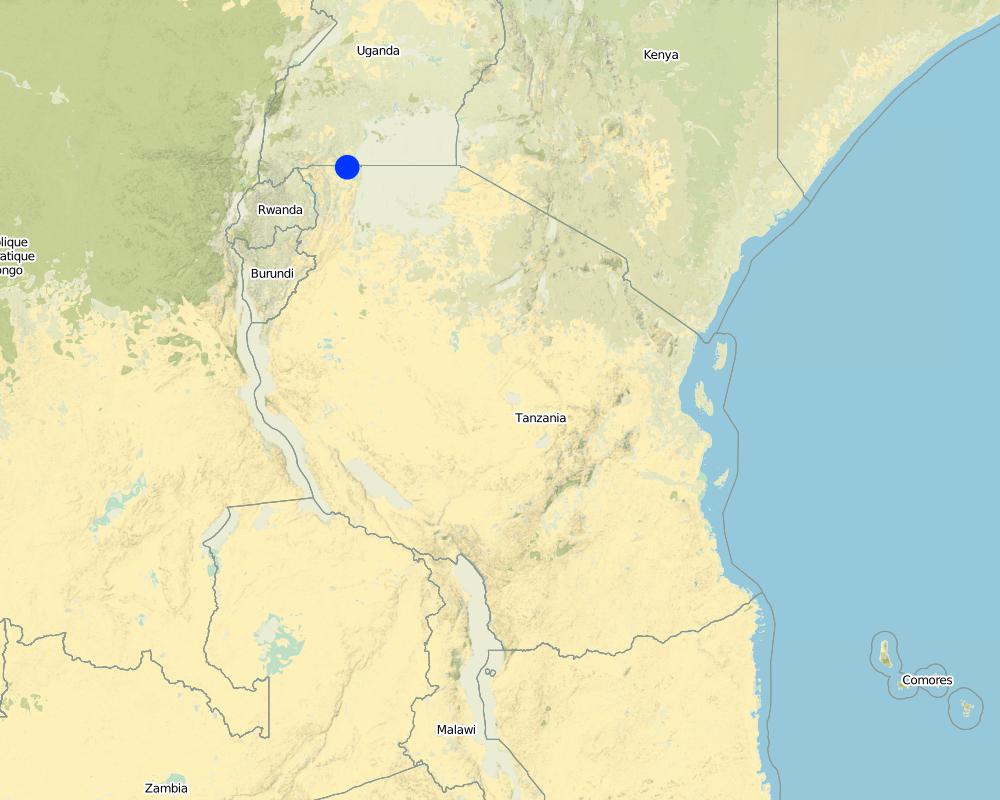
Tanzanie
Région/ Etat/ Province:
Tanzania
Autres spécifications du lieu:
Missenyi District (Minziro)
Spécifiez la diffusion de la Technologie:
- répartie uniformément sur une zone
S'il n'existe pas d'informations exactes sur la superficie, indiquez les limites approximatives de la zone couverte:
- < 0,1 km2 (10 ha)
Commentaires:
Boundary points of the Technology area: -1.11472, 31.655 ; -1,09972, 31.70194
The area is owned by individual farmer. The area is found adjacent to extensive grazing land. Water table is high and there is a permanent underground natural water flows.
Map
×2.6 Date de mise en œuvre de la Technologie
Si l'année précise est inconnue, indiquez la date approximative: :
- il y a plus de 50 ans (technologie traditionnelle)
2.7 Introduction de la Technologie
Spécifiez comment la Technologie a été introduite: :
- dans le cadre d'un système traditionnel (> 50 ans)
Commentaires (type de projet, etc.) :
the technology has been in use for about 80 years ago
3. Classification de la Technologie de GDT
3.2 Type(s) actuel(s) d'utilisation des terres, là où la Technologie est appliquée
Les divers types d'utilisation des terres au sein du même unité de terrain: :
Oui
Précisez l'utilisation mixte des terres (cultures/ pâturages/ arbres):
- Agropastoralisme (y compris les systèmes culture-élevage intégrés)

Terres cultivées
Nombre de période de croissance par an: :
- 2
Précisez:
Longest growing period in days: 120Longest growing period from month to month: September to DecemberSecond longest growing period in days: 90Second longest growing period from month to month: March to May

Pâturages
Pâturage extensif:
- Pastoralisme de type semi-nomade
Type d'animal:
- bétail - laitier
- caprine
- ovins

Forêts/ bois
Commentaires:
Livestock density (if relevant):
10-25 LU /km2
Major land use problems (compiler’s opinion): Eutrophication, siltation, water shortage, deforestation and wildfire outbreaks
Major land use problems (land users’ perception): Drying of the underground water source.
Constraints of mines and extractive industries
Constraints of settlement / urban
Constraints of infrastructure network (roads, railways, pipe lines, power lines)
Constraints of wastelands / deserts / glaciers / swamps
Constraints of recreation
3.4 Approvisionnement en eau
Approvisionnement en eau des terres sur lesquelles est appliquée la Technologie:
- pluvial
3.6 Mesures de GDT constituant la Technologie

pratiques végétales
- V1: Couverture d’arbres et d’arbustes
- V2: Herbes et plantes herbacées pérennes

structures physiques
- S11: Autres

modes de gestion
- M7: Autres
Commentaires:
Specification of other structural measures: water collection pond and animal watering trough
Specification of other management measures: protect water source enclosure by naturally regenerating vegetation
3.7 Principaux types de dégradation des terres traités par la Technologie

dégradation physique des sols
- Pc: compaction

dégradation biologique
- Bc: réduction de la couverture végétale

dégradation hydrique
- Hp: baisse de la qualité des eaux de surface
Commentaires:
Main causes of degradation: deforestation / removal of natural vegetation (incl. forest fires) (cutting of natural tree and removal of grass along the natural water flow way), overgrazing (Compaction by trampling animals, rainfall runoff, siltation of water collection point and disapearence of vegatative cover.), discharges (point contamination of water) (spoilage and contamination of surface water by human and livestock feaces.), population pressure (Overstocking due to increase in the number of livestock), poverty / wealth (low capacity to invest in enviromental friendly energy sources), inputs and infrastructure: (roads, markets, distribution of water points, other, …) (Unavailable improved and reliable water ponds and animal watering troughs), education, access to knowledge and support services (limited knowledge on sustainable use of natural water sources), governance / institutional (limited enforcement of existing environmental regulatory systems.)
Secondary causes of degradation: soil management (excavation and layout that contradict the natural environment), crop management (annual, perennial, tree/shrub), over-exploitation of vegetation for domestic use (fire wood collection from the natural water source), industrial activities and mining, urbanisation and infrastructure development, release of airborne pollutants (urban/industry…), disturbance of water cycle (infiltration / runoff), over abstraction / excessive withdrawal of water (for irrigation, industry, etc.), other human induced causes (specify), change in temperature, change of seasonal rainfall, Heavy / extreme rainfall (intensity/amounts), wind storms / dust storms, floods, droughts, other natural causes (avalanches, volcanic eruptions, mud flows, highly susceptible natural resources, extreme topography, etc.) specify, land tenure, labour availability, war and conflicts
3.8 Prévention, réduction de la dégradation ou réhabilitation des terres dégradées
Spécifiez l'objectif de la Technologie au regard de la dégradation des terres:
- prévenir la dégradation des terres
- restaurer/ réhabiliter des terres sévèrement dégradées
4. Spécifications techniques, activités, intrants et coûts de mise en œuvre
4.1 Dessin technique de la Technologie
Spécifications techniques (associées au dessin technique):
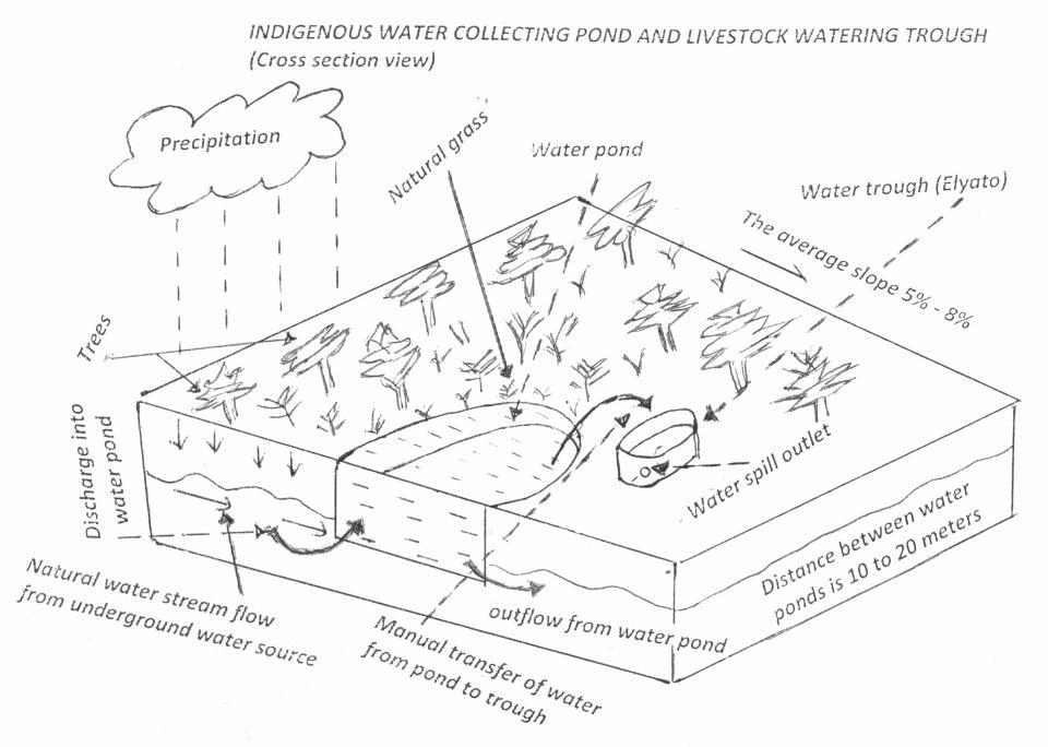
Water pond and water trough cross section view.
The water pond has an average internal capacity of size of 12m3 (4m length, 3m width and 1m depth).
Water troughs are constructed on the side of the water ponds. The water trough outside height is 0.2 - 0.4m above ground, inner depth is 0.5m, and diameter varies from 0.6 to 1m. It is made of cylindrical walls whose average width is 0.1m.
The average slope of the water catchment is 5% to 8%.
Location: Minziro village, Minziro ward, Missenyi division. Missenyi Dist, Kagera Reg, United Rep of Tanzania
Technical knowledge required for land users: moderate (At least primary school leaver with the basic indigenous technical knowledge.)
Main technical functions: control of dispersed runoff: retain / trap, control of concentrated runoff: retain / trap, water harvesting / increase water supply, improvement of water quality, buffering / filtering water
Secondary technical functions: improvement of ground cover, improvement of surface structure (crusting, sealing), stabilisation of soil (eg by tree roots against land slides), increase / maintain water stored in soil, increase of groundwater level / recharge of groundwater, water spreading, sediment retention / trapping, sediment harvesting, increase of biomass (quantity), control of fires, spatial arrangement and diversification of land use
Dam/ pan/ pond
Vertical interval between structures (m): 0
Spacing between structures (m): 10 to 20
Depth of ditches/pits/dams (m): 1
Width of ditches/pits/dams (m): 3
Length of ditches/pits/dams (m): 4
Height of bunds/banks/others (m): 0.3
Width of bunds/banks/others (m): 0.3
Length of bunds/banks/others (m): 4
Structural measure: water trough
Depth of ditches/pits/dams (m): 0.5
Width of ditches/pits/dams (m): 0.6 to 1
Length of ditches/pits/dams (m): 0.6 to 1
Height of bunds/banks/others (m): 0.2
Width of bunds/banks/others (m): 0.1
Length of bunds/banks/others (m): 0.6
Construction material (earth): mostry used clay soil and red termite mound soil.
Construction material (wood): for water pond and trough stabilization
Slope (which determines the spacing indicated above): 8%
If the original slope has changed as a result of the Technology, the slope today is: 8%
Lateral gradient along the structure: 5%
Specification of dams/ pans/ ponds: Capacity 10.6m3
Catchment area: 4 acresm2
For water harvesting: the ratio between the area where the harvested water is applied and the total area from which water is collected is: 1:4
Vegetation is used for stabilisation of structures.
Auteur:
Allan Bubelwa, Box 38 Kyaka Missenyi
Date:
28/8/2012
4.2 Informations générales sur le calcul des intrants et des coûts
autre/ monnaie nationale (précisez):
Tanzanian shillings
Indiquez le taux de change des USD en devise locale, le cas échéant (p.ex. 1 USD = 79.9 réal brésilien): 1 USD = :
1600,0
Indiquez le coût salarial moyen de la main d'œuvre par jour:
3.13
4.3 Activités de mise en place/ d'établissement
| Activité | Calendrier des activités (saisonnier) | |
|---|---|---|
| 1. | Land preparation for pond excavation | During dry season |
| 2. | Construction of pond | During dry period |
| 3. | Construction of water trough | During dry season |
4.4 Coûts et intrants nécessaires à la mise en place
| Spécifiez les intrants | Unité | Quantité | Coûts par unité | Coût total par intrant | % des coût supporté par les exploitants des terres | |
|---|---|---|---|---|---|---|
| Main d'œuvre | Land preparation for pond excavation | person/day | 1,0 | 1,25 | 1,25 | 100,0 |
| Main d'œuvre | Construction of pond | person/day | 1,0 | 21,88 | 21,88 | 100,0 |
| Main d'œuvre | Construction of water trough | person/day | 1,0 | 3,13 | 3,13 | 100,0 |
| Equipements | Tools | piece | 1,0 | 3,13 | 3,13 | 100,0 |
| Equipements | Tools | piece | 3,0 | 9,38 | 28,14 | 100,0 |
| Matériaux de construction | Wood | pieces | 2,0 | 1,25 | 2,5 | 100,0 |
| Matériaux de construction | Earth | kg | 20,0 | 1,25 | 25,0 | 100,0 |
| Coût total de mise en place de la Technologie | 85,03 | |||||
| Coût total de mise en place de la Technologie en dollars américains (USD) | 0,05 | |||||
Commentaires:
Duration of establishment phase: 1 month(s)
4.5 Activités d'entretien/ récurrentes
| Activité | Calendrier/ fréquence | |
|---|---|---|
| 1. | Desiltation | During dry season |
| 2. | Wall and bank strengthening and repair (reshaping and grass slashing/gap filling) | During dry season |
| 3. | Water trough repairing | dry season |
| 4. | Filling to and emptying water from water trough and collection and application of red termite mound soil. |
4.6 Coûts et intrants nécessaires aux activités d'entretien/ récurrentes (par an)
| Spécifiez les intrants | Unité | Quantité | Coûts par unité | Coût total par intrant | % des coût supporté par les exploitants des terres | |
|---|---|---|---|---|---|---|
| Main d'œuvre | Desiltation | person days | 5,0 | 6,25 | 31,25 | 100,0 |
| Main d'œuvre | Wall and bank strengthening and repair (reshaping and grass slashing/gap filling) | person days | 5,0 | 6,25 | 31,25 | 100,0 |
| Main d'œuvre | Water trough repairing | person days | 8,0 | 10,0 | 80,0 | 100,0 |
| Main d'œuvre | Filling to and emptying water from water trough and collection and application of red termite mound soil. | person days | 450,0 | 1,25 | 562,5 | 100,0 |
| Equipements | Tools | pieces | 2,0 | 5,0 | 10,0 | 100,0 |
| Equipements | Water can | pieces | 2,0 | 1,88 | 3,76 | 100,0 |
| Matériaux de construction | Wood | pieces | 6,0 | 3,75 | 22,5 | 100,0 |
| Matériaux de construction | Earth | kg | 60,0 | 3,75 | 225,0 | 100,0 |
| Coût total d'entretien de la Technologie | 966,26 | |||||
| Coût total d'entretien de la Technologie en dollars américains (USD) | 0,6 | |||||
Commentaires:
The cost is calculated per one water pond and its one trough and as per 28 August 2012
4.7 Facteurs les plus importants affectant les coûts
Décrivez les facteurs les plus importants affectant les coûts :
Labour is the most determinant factor affecting the costs
5. Environnement naturel et humain
5.1 Climat
Précipitations annuelles
- < 250 mm
- 251-500 mm
- 501-750 mm
- 751-1000 mm
- 1001-1500 mm
- 1501-2000 mm
- 2001-3000 mm
- 3001-4000 mm
- > 4000 mm
Zone agro-climatique
- humide
- subhumide
Thermal climate class: tropics. all months temperature is above 18
Thermal climate class: subtropics
Thermal climate class: temperate
Thermal climate class: boreal
Thermal climate class: polar/arctic
5.2 Topographie
Pentes moyennes:
- plat (0-2 %)
- faible (3-5%)
- modéré (6-10%)
- onduleux (11-15%)
- vallonné (16-30%)
- raide (31-60%)
- très raide (>60%)
Reliefs:
- plateaux/ plaines
- crêtes
- flancs/ pentes de montagne
- flancs/ pentes de colline
- piémonts/ glacis (bas de pente)
- fonds de vallée/bas-fonds
Zones altitudinales:
- 0-100 m
- 101-500 m
- 501-1000 m
- 1001-1500 m
- 1501-2000 m
- 2001-2500 m
- 2501-3000 m
- 3001-4000 m
- > 4000 m
5.3 Sols
Profondeur moyenne du sol:
- très superficiel (0-20 cm)
- superficiel (21-50 cm)
- modérément profond (51-80 cm)
- profond (81-120 cm)
- très profond (>120 cm)
Texture du sol (de la couche arable):
- fin/ lourd (argile)
Matière organique de la couche arable:
- moyen (1-3%)
- faible (<1%)
5.4 Disponibilité et qualité de l'eau
Profondeur estimée de l’eau dans le sol:
en surface
Disponibilité de l’eau de surface:
bonne
Qualité de l’eau (non traitée):
eau potable
5.6 Caractéristiques des exploitants des terres appliquant la Technologie
Orientation du système de production:
- exploitation mixte (de subsistance/ commerciale)
Niveau relatif de richesse:
- moyen
Individus ou groupes:
- individu/ ménage
Genre:
- femmes
- hommes
Indiquez toute autre caractéristique pertinente des exploitants des terres:
Difference in the involvement of women and men: little involvement of women because at large/traditionally livestock rearing is done by men.
Population density: 50-100 persons/km2
Annual population growth: 2% - 3%
5% of the land users are rich and own 5% of the land.
10% of the land users are average wealthy and own 35% of the land (the techology is used by rich and average livestock keepers who have the animal).
75% of the land users are poor and own 40% of the land (the village poors usually do not have the animals though most of them are cattle herders).
10% of the land users are poor and own 20% of the land.
5.7 Superficie moyenne des terres utilisées par les exploitants des terres appliquant la Technologie
- < 0,5 ha
- 0,5-1 ha
- 1-2 ha
- 2-5 ha
- 5-15 ha
- 15-50 ha
- 50-100 ha
- 100-500 ha
- 500-1 000 ha
- 1 000-10 000 ha
- > 10 000 ha
Cette superficie est-elle considérée comme de petite, moyenne ou grande dimension (en se référant au contexte local)?
- petite dimension
5.8 Propriété foncière, droits d’utilisation des terres et de l'eau
Propriété foncière:
- communauté/ village
- individu, sans titre de propriété
Droits d’utilisation des terres:
- individuel
Droits d’utilisation de l’eau:
- communautaire (organisé)
- individuel
5.9 Accès aux services et aux infrastructures
santé:
- pauvre
- modéré
- bonne
éducation:
- pauvre
- modéré
- bonne
assistance technique:
- pauvre
- modéré
- bonne
emploi (par ex. hors exploitation):
- pauvre
- modéré
- bonne
marchés:
- pauvre
- modéré
- bonne
routes et transports:
- pauvre
- modéré
- bonne
eau potable et assainissement:
- pauvre
- modéré
- bonne
6. Impacts et conclusions
6.1 Impacts sur site que la Technologie a montrés
Impacts socio-économiques
Production
production animale
diversité des produits
production d'énergie
Disponibilité et qualité de l'eau
disponibilité de l'eau potable
Revenus et coûts
diversité des sources de revenus
disparités économiques
Impacts socioculturels
institutions communautaires
institutions nationales
connaissances sur la GDT/ dégradation des terres
Impacts écologiques
Cycle de l'eau/ ruissellement
quantité d'eau
qualité de l'eau
récolte/ collecte de l'eau
ruissellement de surface
nappes phréatiques/ aquifères
évaporation
Sols
humidité du sol
cycle/ recharge des éléments nutritifs
Biodiversité: végétale, animale
biomasse/ au dessus du sol C
diversité des habitats
contrôle des animaux nuisibles/ maladies
Réduction des risques de catastrophe et des risques climatiques
émissions de carbone et de gaz à effet de serre
risques d'incendies
vitesse du vent
6.2 Impacts hors site que la Technologie a montrés
flux des cours d'eau fiables et stables en saison sèche
inondations en aval
capacité tampon/de filtration
dommages sur les champs voisins
6.3 Exposition et sensibilité de la Technologie aux changements progressifs et aux évènements extrêmes/catastrophes liés au climat (telles que perçues par les exploitants des terres)
Changements climatiques progressifs
Changements climatiques progressifs
| Saison | Augmentation ou diminution | Comment la Technologie fait-elle face à cela? | |
|---|---|---|---|
| températures annuelles | augmente | bien |
Extrêmes climatiques (catastrophes)
Catastrophes météorologiques
| Comment la Technologie fait-elle face à cela? | |
|---|---|
| pluie torrentielle locale | pas bien |
| tempête de vent locale | bien |
Catastrophes climatiques
| Comment la Technologie fait-elle face à cela? | |
|---|---|
| sécheresse | bien |
Catastrophes hydrologiques
| Comment la Technologie fait-elle face à cela? | |
|---|---|
| inondation générale (rivière) | pas bien |
Autres conséquences liées au climat
Autres conséquences liées au climat
| Comment la Technologie fait-elle face à cela? | |
|---|---|
| réduction de la période de croissance | pas connu |
Commentaires:
Improving structure on the pond (use impermeable materials to prevent seepage, use concrete as a building material)
6.4 Analyse coûts-bénéfices
Quels sont les bénéfices comparativement aux coûts de mise en place (du point de vue des exploitants des terres)?
Rentabilité à court terme:
positive
Rentabilité à long terme:
positive
Quels sont les bénéfices comparativement aux coûts d'entretien récurrents (du point de vue des exploitants des terres)?
Rentabilité à court terme:
positive
Rentabilité à long terme:
positive
Commentaires:
The technology requires low establishment and maintenance cost and benefit surpass the costs.
6.5 Adoption de la Technologie
De tous ceux qui ont adopté la Technologie, combien d'entre eux l'ont fait spontanément, à savoir sans recevoir aucune incitation matérielle, ou aucune rémunération? :
- 11-50%
Commentaires:
12% of land user families have adopted the Technology without any external material support
250 land user families have adopted the Technology without any external material support
All livestock keepers use the technology to water their animals voluntary and through self mobilization.
There is a moderate trend towards spontaneous adoption of the Technology
The technology is cheap and requires low investment costs.
6.7 Points forts/ avantages/ possibilités de la Technologie
| Points forts/ avantages/ possibilités du point de vue de l'exploitant des terres |
|---|
|
Income generation due to water use fee. How can they be sustained / enhanced? improve service to water users. . |
| Points forts/ avantages/ possibilités du point de vue du compilateur ou d'une autre personne ressource clé |
|---|
|
Reduce conflict between livestock keepers and domestic water users. How can they be sustained / enhanced? Bylaws reinforcement, Area enclosure and Demarcation |
|
Improve accessibility of water to animals (improved animal water intake) How can they be sustained / enhanced? sensitization on regular maintenance. |
6.8 Faiblesses/ inconvénients/ risques de la Technologie et moyens de les surmonter
| Faiblesses/ inconvénients/ risques du point de vue de l’exploitant des terres | Comment peuvent-ils être surmontés? |
|---|---|
| Not durable and requires frequent and regular maintenance | Sensitize on regular maintenance. |
| Faiblesses/ inconvénients/ risques du point de vue du compilateur ou d'une autre personne ressource clé | Comment peuvent-ils être surmontés? |
|---|---|
| not durable | Sensitize on regular maintenance. |
| high labor demand to fill the troughs | Use simple leverage pump |
7. Références et liens
7.1 Méthodes/ sources d'information
7.2 Références des publications disponibles
Titre, auteur, année, ISBN:
Kagera TAMP project website
Disponible à partir d'où? Coût?
http://www.fao.org/nr/kagera/en/
Liens et modules
Développer tout Réduire toutLiens
Aucun lien
Modules
Aucun module trouvé