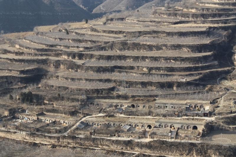
Bench terraces on loess soil [Chine]
- Création :
- Mise à jour :
- Compilateur : Fei WANG
- Rédacteur : –
- Examinateurs : David Streiff, Alexandra Gavilano
土坎梯田,梯地
technologies_1445 - Chine
Voir les sections
Développer tout Réduire tout1. Informations générales
1.2 Coordonnées des personnes-ressources et des institutions impliquées dans l'évaluation et la documentation de la Technologie
Spécialiste GDT:
1.3 Conditions relatives à l'utilisation par WOCAT des données documentées
Le compilateur et la(les) personne(s) ressource(s) acceptent les conditions relatives à l'utilisation par WOCAT des données documentées:
Oui
2. Description de la Technologie de GDT
2.1 Courte description de la Technologie
Définition de la Technologie:
A Terrace is a structural SLM practice with a raised flat platform built on the slope to reduce soil loss and runoff on the slope, increase the rainfall infiltration and yield.
2.2 Description détaillée de la Technologie
Description:
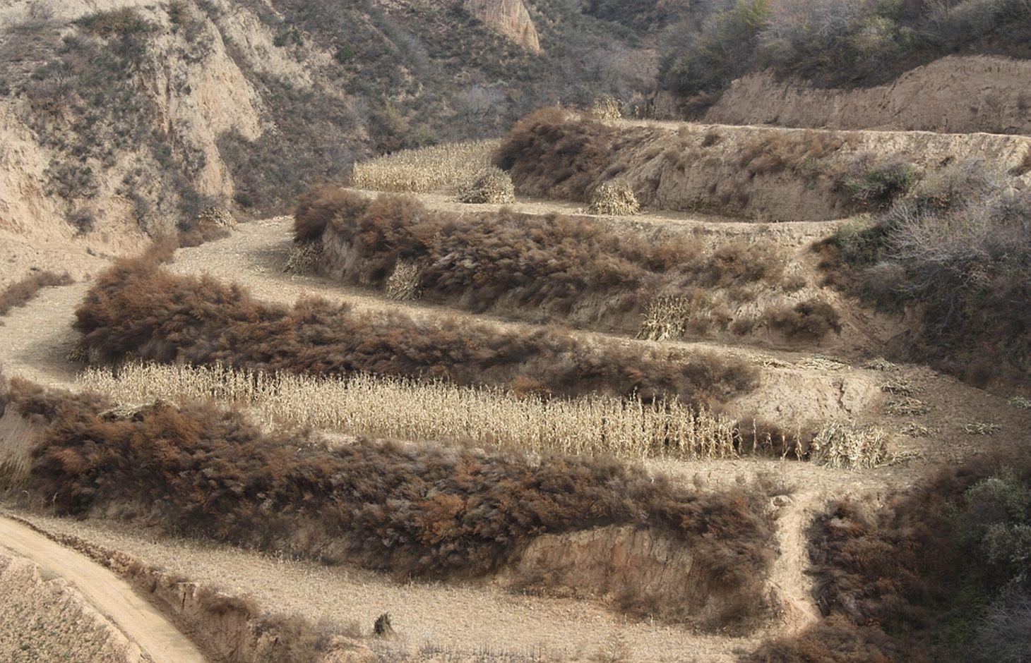
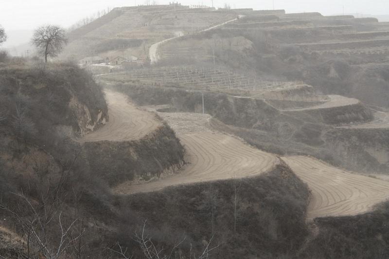
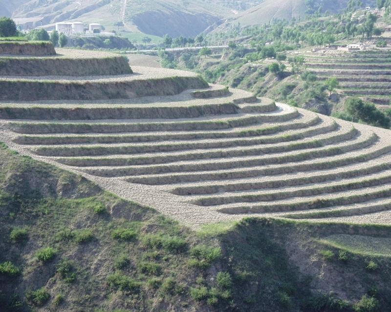
A terrace is a leveled section of a hilly cultivated area, designed as a method of soil conservation to slow or prevent the rapid surface runoff and erosion of topsoil. Often such land is formed into multiple terraces, giving a stepped appearance.
Purpose of the Technology: To change the landform for better agricultural condition of operation of tillage and harvasting, reduction of soil erosion and water loss and finally for higher production.
Establishment / maintenance activities and inputs: The building of a terrace in the loess plateau takes long because loess is very soft and deep and the severe soil erosion and shortage of water in agriculture hinders the process, as well. Previously, terraces were constructed by hand. These terraces weres narrow and damaged by the great storms. Now, the machinery is used to build wide terrace with high bank size in the loess plateau. The establishment of terrace needs a lot of money but it is a long-term investment. The maintenance of terrace is considerable economic because the major efforts are the annually improvment of terrace bunds.
Natural / human environment: The soil erosion is very severe because of the cohesionless loess soil and very intensive rainfall storms in the summer and autumn that would destroy the land surface into broken hilly area. Terrace is a kind of measure to resolve it combining with crops. The human activities here is very intensive because they must plant on the slopes that would make the soil erosion greater.
2.3 Photos de la Technologie
Galerie Médias
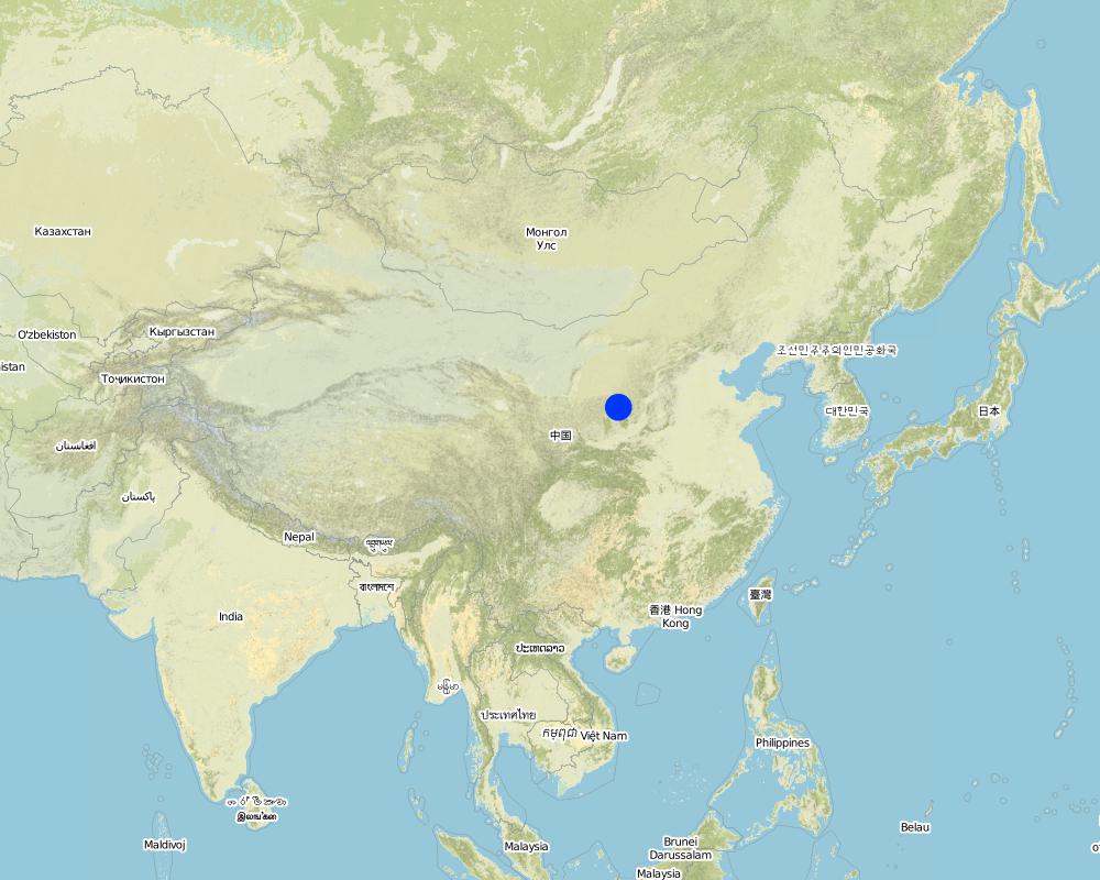
2.5 Pays/ région/ lieux où la Technologie a été appliquée et qui sont couverts par cette évaluation
Pays:
Chine
Région/ Etat/ Province:
Shaanxi Province
Autres spécifications du lieu:
Yanhe River Basin
Spécifiez la diffusion de la Technologie:
- répartie uniformément sur une zone
Si la Technologie est uniformément répartie sur une zone, précisez la superficie couverte (en km2):
253,3
Commentaires:
Total area covered by the SLM Technology is 253.3 km2.
The total area with different measures is till to 2000. Yanhe River is a first class branch of Yellow River, China. The average channel slope is 3.26‰, and the area of whole basin is 7,687 km2. It is in the semi-arid North Temperate Zone with an average annual precipitation varying from 500 to 550 mm, and an average annual air temperature ranging from 8.5 to 11.4℃. It is in hilly gully area of the Loess Plateau covered by loess. The landform is seriously broken by cutting gullies induced by water erosion. The gully density (the length of channel in one km2) is amount to 2.1 to 4.6 km•km-2. The soil loss is severe all along.
The Ganguyi Hydrology Station (109°48′E, 36°42′N) located in the Ganguyi Town, Baota Country, Yan’an City, Shaanxi Province. The area up Ganguyi Hydrology Station is 5,891 km2, including of Jingbian County(256km2), Zhidan County(708km2), Ansai County(2,699km2) and Baota County(2,228km2). The average annual runoff is 0.22 billion m3, and the runoff modulus accounting for 4,776.36 m3•km-2•yr-1. The average annual sediment flow is 4.776
Map
×2.6 Date de mise en œuvre de la Technologie
Si l'année précise est inconnue, indiquez la date approximative: :
- il y a plus de 50 ans (technologie traditionnelle)
2.7 Introduction de la Technologie
Spécifiez comment la Technologie a été introduite: :
- dans le cadre d'un système traditionnel (> 50 ans)
Commentaires (type de projet, etc.) :
The terrace in this site has been formed since 1994 with machinery. The land is quite wide and large enough for agriculture in the hilly loess region,
3. Classification de la Technologie de GDT
3.1 Principal(aux) objectif(s) de la Technologie
- réduire, prévenir, restaurer les terres dégradées
3.2 Type(s) actuel(s) d'utilisation des terres, là où la Technologie est appliquée
Les divers types d'utilisation des terres au sein du même unité de terrain: :
Oui
Précisez l'utilisation mixte des terres (cultures/ pâturages/ arbres):
- Agroforesterie

Terres cultivées
- Cultures annuelles
- Cultures pérennes (non ligneuses)
- Plantations d’arbres ou de buissons
Cultures annuelles - Précisez les cultures:
- céréales - maïs
- céréales - mil
- cultures florales
- cultures fourragères - luzerne
- légumineuses et légumes secs - fèves
- cultures oléagineuses - tournesol, colza, autres
- plantes à racines et à tubercules - pommes de terre
- légumes - autres
Plantations d'arbres et d'arbustes - Précisez les cultures:
- dattes
- fruits à pépins (pommes, poires, coings, etc.)
Nombre de période de croissance par an: :
- 1
Précisez:
Longest growing period in days: 300Longest growing period from month to month: March to NovemberSecond longest growing period in days: 200Second longest growing period from month to month: April to October
Commentaires:
Main cash crops: Beans, sunflower, apple, Chinese date, alfalfa
Main food crops: Potato, millets, maize, buckwheat
other crops: vegetable
Major land use problems (compiler’s opinion): Soil and water losses are alarming in this region. The loose loess, steep slopes, and intensive storms in the summer and autumn, accelerates this process. Aditionally, the lack of rainfall negatively impacts agriculture and vegatation. Sediment deposition could increase the river bed and diminish capacity of reservoirs. On one hand side floods occur frequently because of fast and large runoff and on other hand side sedimentation in rivers reduce their water carring capacity.
Major land use problems (land users’ perception): The low yield of crops and the low income from land is more important for the local people. It is necessary to improve the agricultural conditions. The land, especially the tableland and gentle slope land could be convert into terrace.
Future (final) land use (after implementation of SLM Technology): Cropland: Ca: Annual cropping
Type of cropping system and major crops comments: The composation of agriculture is very simple here.
Livestock is grazing on crop residues
3.3 Est-ce que l’utilisation des terres a changé en raison de la mise en œuvre de la Technologie ?
Est-ce que l’utilisation des terres a changé en raison de la mise en œuvre de la Technologie ?
- Oui (Veuillez remplir les questions ci-après au regard de l’utilisation des terres avant la mise en œuvre de la Technologie)

Pâturages
- Intensive grazing/ fodder production
3.4 Approvisionnement en eau
Approvisionnement en eau des terres sur lesquelles est appliquée la Technologie:
- pluvial
3.5 Groupe de GDT auquel appartient la Technologie
- mesures en travers de la pente
3.6 Mesures de GDT constituant la Technologie

pratiques végétales
- V2: Herbes et plantes herbacées pérennes

structures physiques
- S1: Terrasses

modes de gestion
- M1: Changement du type d’utilisation des terres
Commentaires:
Main measures: structural measures
Secondary measures: vegetative measures, management measures
Type of vegetative measures: aligned: -along boundary
3.7 Principaux types de dégradation des terres traités par la Technologie

érosion hydrique des sols
- Wt: perte de la couche superficielle des sols (couche arable)/ érosion de surface

dégradation hydrique
- Hs: changement de la quantité d’eau de surface
- Hw: réduction de la capacité tampon des zones humides
Commentaires:
Main type of degradation addressed: Wt: loss of topsoil / surface erosion
Secondary types of degradation addressed: Hs: change in quantity of surface water, Hw: reduction of the buffering capacity of wetland areas
Main causes of degradation: deforestation / removal of natural vegetation (incl. forest fires) (The natural vegetation in this region is grass on theslope and trees on the gully and alluvial land. After the destroy of natural, the soil loss increases greatly.), Heavy / extreme rainfall (intensity/amounts) (About 70% of annual rainfall is in the summer and autumn. The storm is very intensive.), population pressure (The population density account for 71 capita per square km.)
Secondary causes of degradation: droughts (The rainfall varies greatly in different year and different seasons. The drought happened frenquently.)
3.8 Prévention, réduction de la dégradation ou réhabilitation des terres dégradées
Spécifiez l'objectif de la Technologie au regard de la dégradation des terres:
- réduire la dégradation des terres
Commentaires:
Main goals: mitigation / reduction of land degradation
4. Spécifications techniques, activités, intrants et coûts de mise en œuvre
4.1 Dessin technique de la Technologie
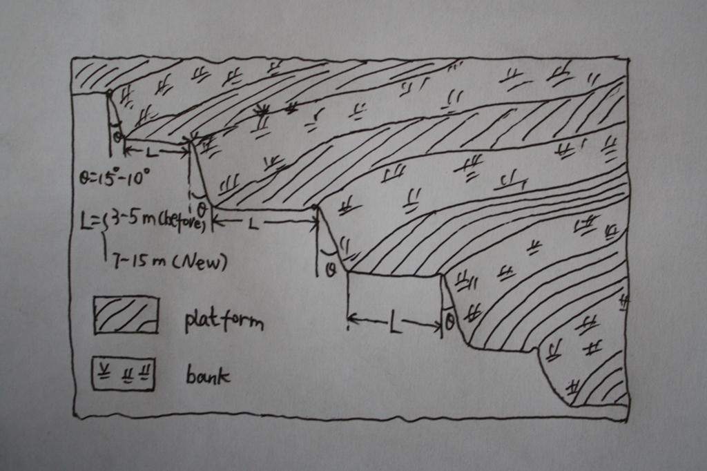
Spécifications techniques (associées au dessin technique):
The brief structure of terrace in the Yanhe River Basin.
Location: Zhifanggou Watershed. Ansai County, Shaanxi, China
Date: 2008-12-15
Technical knowledge required for field staff / advisors: low (The location selection and how to build a good terrace need special knowledge on soil engineering.)
Technical knowledge required for land users: moderate (It is easy to know the benefit for all the local farmers.)
Main technical functions: control of concentrated runoff: retain / trap, reduction of slope angle, increase of infiltration
Secondary technical functions: increase / maintain water stored in soil, improvement of water quality, buffering / filtering water, increase of biomass (quantity)
Aligned: -along boundary
Vegetative material: G : grass
Number of plants per (ha): 50000
Vertical interval between rows / strips / blocks (m): 2.5
Spacing between rows / strips / blocks (m): 0.5
Grass species: Natural grass to protect the bank of terrace.
Slope (which determines the spacing indicated above): 20.00%
If the original slope has changed as a result of the Technology, the slope today is (see figure below): 2.00%
Gradient along the rows / strips: 1.00%
Terrace: bench level
Vertical interval between structures (m): 2.5
Spacing between structures (m): 8
Height of bunds/banks/others (m): 2.5
Width of bunds/banks/others (m): 8
Length of bunds/banks/others (m): 50-100
Construction material (earth): The terrace in the Loess Plateau are used local soil/earth directly.
Slope (which determines the spacing indicated above): 30%
If the original slope has changed as a result of the Technology, the slope today is: 30-60%
Lateral gradient along the structure: 2%
Vegetation is used for stabilisation of structures.
Change of land use type: Wild grassland or range land before mostly. Some time the cropland on the slope.
Change of land use practices / intensity level: The labor is less intensive on the plain platform.
Auteur:
Wang Fei, Yangling, Shaanxi, China
4.2 Informations générales sur le calcul des intrants et des coûts
Indiquez la monnaie utilisée pour le calcul des coûts:
- dollars américains
Indiquez le taux de change des USD en devise locale, le cas échéant (p.ex. 1 USD = 79.9 réal brésilien): 1 USD = :
0,83
Indiquez le coût salarial moyen de la main d'œuvre par jour:
8.8
4.3 Activités de mise en place/ d'établissement
| Activité | Calendrier des activités (saisonnier) | |
|---|---|---|
| 1. | Survey and design | Before construction |
| 2. | Move the topsoil to other place | 1st step of construction |
| 3. | Built the platform and bank with soil digged | 2nd step of construction |
| 4. | Backcover the topsoil on the surface of platform | 3rd step of construction |
| 5. | Check and accept the terrace | After the terrace finished |
4.4 Coûts et intrants nécessaires à la mise en place
| Spécifiez les intrants | Unité | Quantité | Coûts par unité | Coût total par intrant | % des coût supporté par les exploitants des terres | |
|---|---|---|---|---|---|---|
| Main d'œuvre | Survey and design | Person/day | 45,0 | 8,8 | 396,0 | 100,0 |
| Main d'œuvre | Building terraces (machine price included) | Person/day | 75,0 | 19,0 | 1425,0 | 100,0 |
| Coût total de mise en place de la Technologie | 1821,0 | |||||
| Coût total de mise en place de la Technologie en dollars américains (USD) | 2193,98 | |||||
Commentaires:
Duration of establishment phase: 0.5 month(s)
4.5 Activités d'entretien/ récurrentes
| Activité | Calendrier/ fréquence | |
|---|---|---|
| 1. | Reinforce the bank | annually |
| 2. | Fill the erosion hole of the landform | annually |
| 3. | Build the edge in some terraces | annually |
| 4. | Reinforce the bank | annually |
| 5. | Fill the erosion hole of the landform | annually |
| 6. | Build the edge in some terraces | annually |
4.6 Coûts et intrants nécessaires aux activités d'entretien/ récurrentes (par an)
| Spécifiez les intrants | Unité | Quantité | Coûts par unité | Coût total par intrant | % des coût supporté par les exploitants des terres | |
|---|---|---|---|---|---|---|
| Main d'œuvre | Keep Terraces in shape | Person/day | 30,0 | 8,8 | 264,0 | 100,0 |
| Coût total d'entretien de la Technologie | 264,0 | |||||
| Coût total d'entretien de la Technologie en dollars américains (USD) | 318,07 | |||||
Commentaires:
Machinery/ tools: Crawl dozer and small traditional hand tool., crawler tractor, spade
In general condition, slope and soil, in the middle reaches of Yan River Basin. The prices of labour-day and Machine-hour are around 2005.
4.7 Facteurs les plus importants affectant les coûts
Décrivez les facteurs les plus importants affectant les coûts :
The terrace on the steep slope need more input for more soil and earth should be moved. It is the most important factor.The soil depth is not so important for the deep soil layer here.The cost of labour increases greatly in the last several years and the cost of construction of terrace increased.
5. Environnement naturel et humain
5.1 Climat
Précipitations annuelles
- < 250 mm
- 251-500 mm
- 501-750 mm
- 751-1000 mm
- 1001-1500 mm
- 1501-2000 mm
- 2001-3000 mm
- 3001-4000 mm
- > 4000 mm
Spécifications/ commentaires sur les précipitations:
The mean annual rainfall in the basin is 515.2 mm in the duration from 1952 to 2000. The rainfall from May to Oct accounts for 446.8 mm, up to 86.7%; and that from Jun to Sep accounts for 367.6 mm, up
Zone agro-climatique
- semi-aride
Thermal climate class: temperate. The accumulating time that temperature above 0 ℃ about 3800 hours, and that above 10 ℃ is more than 3200 hours.
5.2 Topographie
Pentes moyennes:
- plat (0-2 %)
- faible (3-5%)
- modéré (6-10%)
- onduleux (11-15%)
- vallonné (16-30%)
- raide (31-60%)
- très raide (>60%)
Reliefs:
- plateaux/ plaines
- crêtes
- flancs/ pentes de montagne
- flancs/ pentes de colline
- piémonts/ glacis (bas de pente)
- fonds de vallée/bas-fonds
Zones altitudinales:
- 0-100 m
- 101-500 m
- 501-1000 m
- 1001-1500 m
- 1501-2000 m
- 2001-2500 m
- 2501-3000 m
- 3001-4000 m
- > 4000 m
Indiquez si la Technologie est spécifiquement appliquée dans des:
- situations convexes
Commentaires et précisions supplémentaires sur la topographie:
Landforms also: mountain slopes and hill slopes
Slopes on average also very steep
5.3 Sols
Profondeur moyenne du sol:
- très superficiel (0-20 cm)
- superficiel (21-50 cm)
- modérément profond (51-80 cm)
- profond (81-120 cm)
- très profond (>120 cm)
Texture du sol (de la couche arable):
- moyen (limoneux)
Matière organique de la couche arable:
- faible (<1%)
Si disponible, joignez une description complète du sol ou précisez les informations disponibles, par ex., type de sol, pH/ acidité du sol, capacité d'échange cationique, azote, salinité, etc.
Soil texture: There are more than 50% soil particle are fine sand with size between 0.05 and 0.1 mm.
Soil fertility very low: Lack of N, P and SOM.
Topsoil organic matter: The average Top-SOM of cropland is about 0.05%
Soil drainage / infiltration good: The inflitration of Loess is very fast, but it is prone to sealing when flashing.
Soil water storage capacity low: It is easy to evaporation and drainage.
5.4 Disponibilité et qualité de l'eau
Profondeur estimée de l’eau dans le sol:
5-50 m
Disponibilité de l’eau de surface:
moyenne
Qualité de l’eau (non traitée):
faiblement potable (traitement nécessaire)
Commentaires et précisions supplémentaires sur la qualité et la quantité d'eau:
Availability of surface water medium: It is very stable in this region.
Availability of surface water also poor/none: Nearly all the branches of Yanhe are seasonal river.
Ground water table: It depends on the landform. In valley and alluvial land, it is shallow.
Water quality: Good quality for there are few pollution sources.
5.5 Biodiversité
Diversité des espèces:
- moyenne
Commentaires et précisions supplémentaires sur la biodiversité:
It is very stable in this region.
5.6 Caractéristiques des exploitants des terres appliquant la Technologie
Orientation du système de production:
- exploitation mixte (de subsistance/ commerciale)
- commercial/ de marché
Revenus hors exploitation:
- 10-50% de tous les revenus
Niveau relatif de richesse:
- moyen
Individus ou groupes:
- individu/ ménage
Niveau de mécanisation:
- travail manuel
- traction animale
Genre:
- femmes
- hommes
Indiquez toute autre caractéristique pertinente des exploitants des terres:
Land users applying the Technology are mainly common / average land users
Difference in the involvement of women and men: No clear difference.
Population density: 50-100 persons/km2
Annual population growth: < 0.5%
80% of the land users are average wealthy (The terrace are build together in some villages for all the people funded by national subsidy.).
Off-farm income specification: The yield of terrace is much high and stable.
Level of mechanization manual work: The harvesting and other management are by hand, even the tillage on the nerrow terrace
Level of mechanization animal traction: Tillage with animal power mostly in the wider terrace.
Market orientation mixed subsistence/ commercial: Some production for themselves, but most of production is exchanged on the market.
5.7 Superficie moyenne des terres utilisées par les exploitants des terres appliquant la Technologie
- < 0,5 ha
- 0,5-1 ha
- 1-2 ha
- 2-5 ha
- 5-15 ha
- 15-50 ha
- 50-100 ha
- 100-500 ha
- 500-1 000 ha
- 1 000-10 000 ha
- > 10 000 ha
Cette superficie est-elle considérée comme de petite, moyenne ou grande dimension (en se référant au contexte local)?
- petite dimension
Commentaires:
According to 0.054 ha per capita.
5.8 Propriété foncière, droits d’utilisation des terres et de l'eau
Propriété foncière:
- état
- communauté/ village
Droits d’utilisation des terres:
- individuel
Droits d’utilisation de l’eau:
- accès libre (non organisé)
Commentaires:
Like other rural area in China.
5.9 Accès aux services et aux infrastructures
santé:
- pauvre
- modéré
- bonne
éducation:
- pauvre
- modéré
- bonne
emploi (par ex. hors exploitation):
- pauvre
- modéré
- bonne
routes et transports:
- pauvre
- modéré
- bonne
eau potable et assainissement:
- pauvre
- modéré
- bonne
services financiers:
- pauvre
- modéré
- bonne
6. Impacts et conclusions
6.1 Impacts sur site que la Technologie a montrés
Impacts socio-économiques
Production
production agricole
Quantité avant la GDT:
600
Quantité après la GDT:
2200
production animale
production de bois
risque d'échec de la production
diversité des produits
surface de production
Disponibilité et qualité de l'eau
disponibilité de l'eau potable
qualité de l'eau potable
Revenus et coûts
revenus agricoles
Quantité avant la GDT:
43.9
Quantité après la GDT:
120
diversité des sources de revenus
charge de travail
Impacts socioculturels
sécurité alimentaire/ autosuffisance
apaisement des conflits
Livelihoods and human well-being
Impacts écologiques
Cycle de l'eau/ ruissellement
récolte/ collecte de l'eau
ruissellement de surface
évaporation
Commentaires/ spécifiez:
Evaporation form the wall of terrace, Especially for the narrow terrace
Sols
humidité du sol
Commentaires/ spécifiez:
More inflitration of rainfall, but the evaporation near to the wall increases
couverture du sol
perte en sol
Quantité avant la GDT:
10000t/km^
Quantité après la GDT:
2000t/km^2
Biodiversité: végétale, animale
biomasse/ au dessus du sol C
diversité végétale
Autres impacts écologiques
Hazards towards adverse events
6.2 Impacts hors site que la Technologie a montrés
flux des cours d'eau fiables et stables en saison sèche
inondations en aval
envasement en aval
capacité tampon/de filtration
sédiments (indésirables) transportés par le vent
dommages sur les champs voisins
dommages sur les infrastructures publiques/ privées
6.3 Exposition et sensibilité de la Technologie aux changements progressifs et aux évènements extrêmes/catastrophes liés au climat (telles que perçues par les exploitants des terres)
Changements climatiques progressifs
Changements climatiques progressifs
| Saison | Augmentation ou diminution | Comment la Technologie fait-elle face à cela? | |
|---|---|---|---|
| températures annuelles | augmente | bien |
Extrêmes climatiques (catastrophes)
Catastrophes météorologiques
| Comment la Technologie fait-elle face à cela? | |
|---|---|
| pluie torrentielle locale | pas bien |
| tempête de vent locale | bien |
Catastrophes climatiques
| Comment la Technologie fait-elle face à cela? | |
|---|---|
| sécheresse | pas connu |
Catastrophes hydrologiques
| Comment la Technologie fait-elle face à cela? | |
|---|---|
| inondation générale (rivière) | bien |
Autres conséquences liées au climat
Autres conséquences liées au climat
| Comment la Technologie fait-elle face à cela? | |
|---|---|
| réduction de la période de croissance | pas connu |
Commentaires:
Loess is very prone to erosion and extreme storms would destory the bank of terrace. In the study site sesonal rainfall increased and the loess terrace could retain more soil water and reduce the runoff.
6.4 Analyse coûts-bénéfices
Quels sont les bénéfices comparativement aux coûts de mise en place (du point de vue des exploitants des terres)?
Rentabilité à court terme:
légèrement positive
Rentabilité à long terme:
positive
Quels sont les bénéfices comparativement aux coûts d'entretien récurrents (du point de vue des exploitants des terres)?
Rentabilité à court terme:
légèrement positive
Rentabilité à long terme:
très positive
Commentaires:
The yield of terrace is stable and relative higher. The income from terrace is high and the maintain cost is low.
6.5 Adoption de la Technologie
- 1-10%
Si disponible, quantifiez (nombre de ménages et/ou superficie couverte):
100 households
De tous ceux qui ont adopté la Technologie, combien d'entre eux l'ont fait spontanément, à savoir sans recevoir aucune incitation matérielle, ou aucune rémunération? :
- 0-10%
Commentaires:
90% of land user families have adopted the Technology with external material support
95 land user families have adopted the Technology with external material support
Comments on acceptance with external material support: Most land farmers have some terrace. I do not know the exact number of land user families who adopted the technology.
10% of land user families have adopted the Technology without any external material support
5 land user families have adopted the Technology without any external material support
Comments on spontaneous adoption: the old narrow terraces, now a very small area left, are build voluntarily.
There is a strong trend towards spontaneous adoption of the Technology
Comments on adoption trend: Nearly all the people know the benefit of terrace. the benefits of terraces are very good for crops and orchards are high enough in this region.
6.7 Points forts/ avantages/ possibilités de la Technologie
| Points forts/ avantages/ possibilités du point de vue de l'exploitant des terres |
|---|
|
Increase yield and income. How can they be sustained / enhanced? If the terrace is maintained well, the water condition would be better than that on the slope land even in dry year with low precipitation. |
|
Convenient to till and harvest How can they be sustained / enhanced? Tillage and harvesting is much easier on the plain flat land than on the slope. The maintainance of terrace is important. |
| Points forts/ avantages/ possibilités du point de vue du compilateur ou d'une autre personne ressource clé |
|---|
|
Reduce soil erosion on the slope. How can they be sustained / enhanced? The loess soil is prone to erosion because of its loose character induced by fine sand content and low soil organic matter. The plain flat makes the dispersion and transportation of soil particls difficult. |
|
Reduce runoff and increase the soil moisture How can they be sustained / enhanced? The runoff generation is smaller on the plain than on the slope. Slow movement of surface water lead to more soil infiltration. |
|
Increase yield. How can they be sustained / enhanced? Water is the limit factor in the loess plateau. The yield would increase if there is enough water available. |
|
Decrease flood risk. How can they be sustained / enhanced? It is a kind of off-site benefits because less runoff generation and gentle process of runoff decrease flooding. Reduction of sediment also diminish flood risk because the drainage capacity of channel and adjusting capacity of reservior increase when sedimentation decrease. |
6.8 Faiblesses/ inconvénients/ risques de la Technologie et moyens de les surmonter
| Faiblesses/ inconvénients/ risques du point de vue de l’exploitant des terres | Comment peuvent-ils être surmontés? |
|---|---|
| The output is also low in contrast with other industries. | No way to overcome it. The total and net income is too low because the area of terrace per capita is very small. |
| The income is relative compared with other industries. | No way to overcome it. The net income is low because the labour costs are increasing, and the total income because labour cost and very small area of terrace per capita. |
| Faiblesses/ inconvénients/ risques du point de vue du compilateur ou d'une autre personne ressource clé | Comment peuvent-ils être surmontés? |
|---|---|
| There is possible damage of terraces because the loess is very loosen and prone to collapse. | Keep upmaintaining the bank and land well. |
| Decrease runoff of lower stream. | No way to overcome it, but it also could decrease the risk of floods. |
7. Références et liens
7.1 Méthodes/ sources d'information
7.2 Références des publications disponibles
Titre, auteur, année, ISBN:
Soil and water conservation records of Shaanxi Province. 2000. Shaanxi People's Press, Xi'an City, China
Disponible à partir d'où? Coût?
Library of ISWC, CAS
Titre, auteur, année, ISBN:
The soil and agriculture of the Loess Plateau. 1989. Zhu Xianmo, Agriculture Press, Beijing City, China
Disponible à partir d'où? Coût?
Library of ISWC, CAS
Titre, auteur, année, ISBN:
Statistical tearbook of Yan'an. 2003. Compiled by Editorial Board of Statistical tearbook of Yan'an
Disponible à partir d'où? Coût?
Library of ISWC, CAS
Titre, auteur, année, ISBN:
Impact of human activities on runoff and sediment change of Yanhe River based on the periods divided by sediment concentration. 2008. WANG Fei , MU Xing-min ,JIAO Ju-ying, LI Rui. Journal of Sediment Research
Disponible à partir d'où? Coût?
http://159.226.100.28/asp/Detail.asp
Titre, auteur, année, ISBN:
Changes of soil erosion intensity due to conversion of farmland to forest and grassland in Yanhe River. 2007. BasinWang Bangwen, yang Qinke, Liu Zhihong, Meng Qingxiang, Science of Soil and Water Conservation
Disponible à partir d'où? Coût?
http://159.226.100.28/asp/Detail.asp
Liens et modules
Développer tout Réduire toutLiens
Aucun lien
Modules
Aucun module trouvé