Stone wall check dam [Ethiopie]
- Création :
- Mise à jour :
- Compilateur : Simon Bach
- Rédacteur : –
- Examinateurs : Fabian Ottiger, Alexandra Gavilano
Yedengay Keter (Amharic)
technologies_1526 - Ethiopie
Voir les sections
Développer tout Réduire tout1. Informations générales
1.2 Coordonnées des personnes-ressources et des institutions impliquées dans l'évaluation et la documentation de la Technologie
Personne(s)-ressource(s) clé(s)
Spécialiste GDT:
Bach Simon
Centre for Development and Environment (CDE), University of Bern
Suisse
Spécialiste GDT:
Ayele Habtamu
Haramaya University
Ethiopie
Nom du ou des institutions qui ont facilité la documentation/ l'évaluation de la Technologie (si pertinent)
Haramaya University (HU) - Ethiopie1.3 Conditions relatives à l'utilisation par WOCAT des données documentées
Le compilateur et la(les) personne(s) ressource(s) acceptent les conditions relatives à l'utilisation par WOCAT des données documentées:
Oui
2. Description de la Technologie de GDT
2.1 Courte description de la Technologie
Définition de la Technologie:
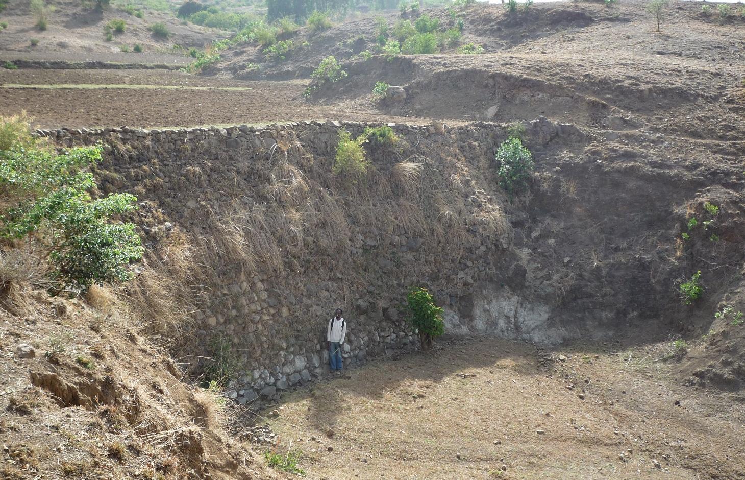
Stone wall check dams are built across a gully to collect alluvial soil and hinder further gully erosion.
2.2 Description détaillée de la Technologie
Description:
During the 1980s stone walls and terraces were introduced in Ethiopia in order to combat soil erosion. The technology of stone walls or terraces is used to stabilize hills or to refill gullies also in Bati, Ethiopia. Stone walls can form a very strong check dam to rehabilitate gullies even several meters deep.
Purpose of the Technology: Although stone walls can be used for different purposes, this case study is focusing on stone walls used to combat gully erosion. Farmers in the Bati region often use stone walls to rehabilitate gullies if the material is easily accessible, otherwise they may search for alternatives.
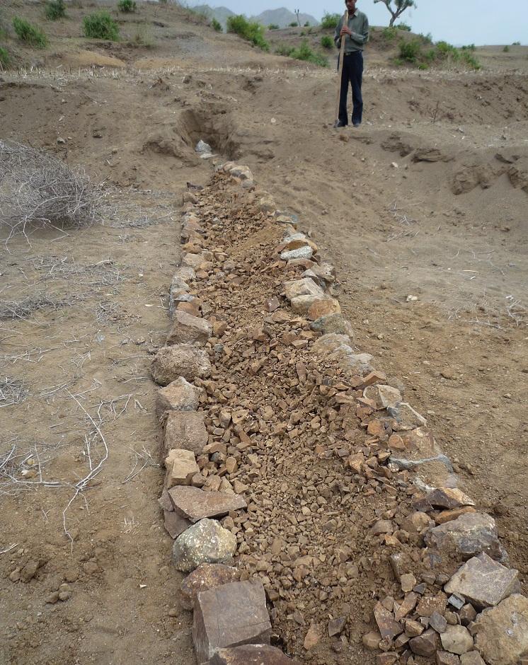
Establishment / maintenance activities and inputs: Following procedure is undertaken to build a stone wall check dam: After breaking the stones in the source-area they are transported to the target-area either by hand, by camels or by donkeys, depending on the distance. After digging a foundation for the wall of approximately 30 cm depth, the gap between two rows of big stones 1 m apart is filled up with smaller stones and gravel. These actions are repeated until the desired height and width of the wall are reached
Natural / human environment: The case study site, Bati, lays in an semiarid climatic zone on 1600 m a.s.l. Rainfalls are erratic and the rain sum per year is between 500-1000 mm. The landscape is very hilly with rather steep slopes. As almost in all Ethiopia, the area has a high population density and growth. The agricultural sector is very dominant and lead by a lot of small scale farming with a lot of livestock and small plots of cropland.
2.3 Photos de la Technologie
Galerie Médias
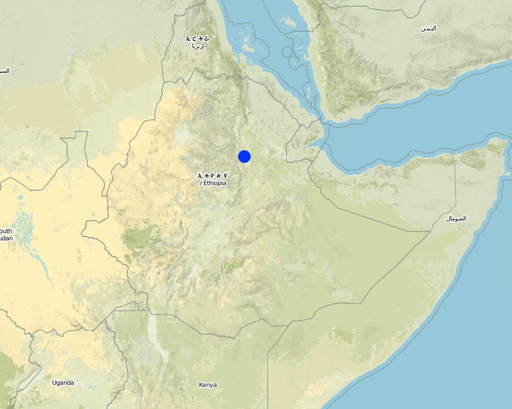
2.5 Pays/ région/ lieux où la Technologie a été appliquée et qui sont couverts par cette évaluation
Pays:
Ethiopie
Région/ Etat/ Province:
Ethiopia / Amhara Region
Autres spécifications du lieu:
Bati
Commentaires:
Total area covered by the SLM Technology is 0.6 km2.
Size of the case study watershed.
Map
×2.6 Date de mise en œuvre de la Technologie
Si l'année précise est inconnue, indiquez la date approximative: :
- il y a entre 10-50 ans
2.7 Introduction de la Technologie
Spécifiez comment la Technologie a été introduite: :
- par le biais de projets/ d'interventions extérieures
Commentaires (type de projet, etc.) :
Soil and water conservation measures, including stone wall check dams, were mainly introduced to land users during the 1980s by the government. Sometimes the technology is not adequately performed though. In recent years the local Agricultural Office is teaching farmers how to correctly build soil and water conservation measures not only on a technology basis but to take care of an integrated watershed management.
3. Classification de la Technologie de GDT
3.1 Principal(aux) objectif(s) de la Technologie
- réduire, prévenir, restaurer les terres dégradées
3.2 Type(s) actuel(s) d'utilisation des terres, là où la Technologie est appliquée

Terres cultivées
- Cultures annuelles
Cultures annuelles - Précisez les cultures:
- céréales - sorgho
- corn
Précisez:
Longest growing period in days: 90 Longest growing period from month to month: June until September

Pâturages
- Mixed farming
Type d'animal:
- chameaux
- bétail - laitier
- caprine
- volailles
- ovins
- (Goat/sheep are main meat source (in household or on market))
Commentaires:
Livestock density (if relevant):
> 100 LU /km2
Major land use problems (compiler’s opinion): Deforestation, overgrazing, cultivation of erosion-sensitive areas or steep slopes.
Major land use problems (land users’ perception): Too much soil loss and land degradation, no vegetation cover and poor soil moisture.
Grazingland comments: Livestock is not fenced in. Children herd the animals and watch out that they do not browse through crop fields. In off-farming season crop residues are collected from the field and stored next to the field. Animals are allowed to eat the still remaining residues on the field. After that, the animals are fed by the collected crop residues.
Livestock is grazing on crop residues
3.4 Approvisionnement en eau
Approvisionnement en eau des terres sur lesquelles est appliquée la Technologie:
- mixte: pluvial-irrigué
Commentaires:
Water supply: Also rainfed
3.5 Groupe de GDT auquel appartient la Technologie
- mesures en travers de la pente
3.6 Mesures de GDT constituant la Technologie

structures physiques
- S1: Terrasses
- S5: Barrages/retenues, micro-bassins, étangs
- S6: Murs, barrières, palissades, clôtures
Commentaires:
Main measures: structural measures
3.7 Principaux types de dégradation des terres traités par la Technologie

érosion hydrique des sols
- Wt: perte de la couche superficielle des sols (couche arable)/ érosion de surface
- Wg: ravinement/ érosion en ravines
Commentaires:
Main type of degradation addressed: Wg: gully erosion / gullying
Secondary types of degradation addressed: Wt: loss of topsoil / surface erosion
Main causes of degradation: deforestation / removal of natural vegetation (incl. forest fires) (Deforestation for the past 30 years.), over-exploitation of vegetation for domestic use (Wood collection for cooking and construction.), overgrazing (50% of the watershed area are cultivated - big grazing pressure on remaining land), other human induced causes (specify) (Cultivation of very steep slopes.), change of seasonal rainfall (Erratic rainfall.), Heavy / extreme rainfall (intensity/amounts) (If there is rain, it is intensive.), population pressure (High population pressure.), poverty / wealth (Poor facilities.)
Secondary causes of degradation: soil management (Poor soil management practices and lack of awareness.), crop management (annual, perennial, tree/shrub) (Annual cropping.), droughts (The research area is considered rather dry.), land tenure (If the land is rented, it is poorly managed.), inputs and infrastructure: (roads, markets, distribution of water points, other, …) (Poor access to fertilizer. Bad infrastructures.), education, access to knowledge and support services (Lack of awareness for soil degradation.), Low productivity of the land (As a consequence seeking for new/larger areas to increase production.)
3.8 Prévention, réduction de la dégradation ou réhabilitation des terres dégradées
Spécifiez l'objectif de la Technologie au regard de la dégradation des terres:
- réduire la dégradation des terres
- restaurer/ réhabiliter des terres sévèrement dégradées
Commentaires:
Secondary goals: mitigation / reduction of land degradation
4. Spécifications techniques, activités, intrants et coûts de mise en œuvre
4.1 Dessin technique de la Technologie
Spécifications techniques (associées au dessin technique):
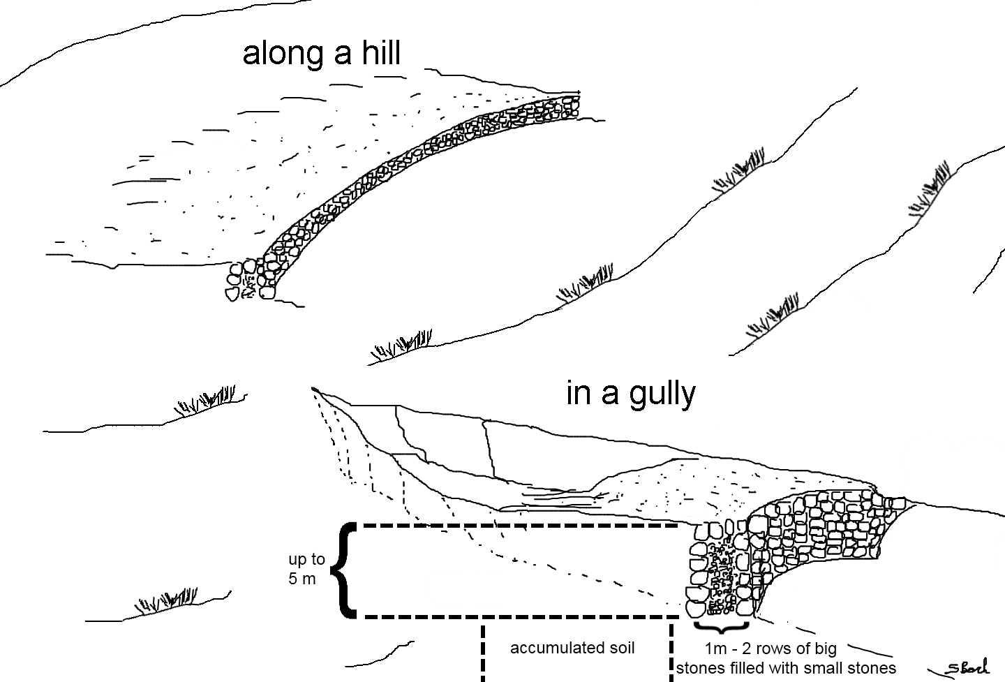
Stone wall check dams as they can be found in the region of Bati. The approximately 1 m wide gap between two rows of larger stones is filled up with small stones or gravel. This is done for every new level of the wall until the wall reaches its final height. The first row of stones is placed in the top 30 cm of the ground and on each side the dam is entering the hill to some extent. After a wall has silted up, the height is increased by other rows of stones until desired dimension is reached. Walls up to 5 m can be found in the case study site.
Location: South-West of Bati. Bati Woreda, Amhara Region, Ethiopia
Date: 26.04.2011
Technical knowledge required for field staff / advisors: moderate (To teach the farmers how to perform an integrated watershed management.)
Technical knowledge required for land users: high (To build a robust check dam there is a lot of knowledge needed.)
Main technical functions: control of concentrated runoff: retain / trap, control of concentrated runoff: impede / retard, reduction of slope angle, reduction of slope length, increase / maintain water stored in soil, sediment retention / trapping, sediment harvesting
Secondary technical functions: water harvesting / increase water supply, improvement of water quality, buffering / filtering water
Retention/infiltration ditch/pit, sediment/sand trap
Depth of ditches/pits/dams (m): 6
Width of ditches/pits/dams (m): 10
Length of ditches/pits/dams (m): 1
If the original slope has changed as a result of the Technology, the slope today is: 0%
Auteur:
Simon Bach, CDE, Bern, Switzerland
4.2 Informations générales sur le calcul des intrants et des coûts
autre/ monnaie nationale (précisez):
Ethiopian Birr
Indiquez le taux de change des USD en devise locale, le cas échéant (p.ex. 1 USD = 79.9 réal brésilien): 1 USD = :
16,82
Indiquez le coût salarial moyen de la main d'œuvre par jour:
1.00
4.3 Activités de mise en place/ d'établissement
| Activité | Calendrier des activités (saisonnier) | |
|---|---|---|
| 1. | Preparation of the stones (500 person days needed). | During dry season. |
| 2. | Transportation of the stones (depending on the distance). | During dry season. |
| 3. | Digging a foundation of 30 cm depth (165 person days needed). | During dry season. |
| 4. | Building of the stone wall (500 person days needed). | During dry season. |
4.4 Coûts et intrants nécessaires à la mise en place
| Spécifiez les intrants | Unité | Quantité | Coûts par unité | Coût total par intrant | % du coût supporté par les exploitants des terres | |
|---|---|---|---|---|---|---|
| Main d'œuvre | Labour | ha | 1,0 | 1165,0 | 1165,0 | 50,0 |
| Equipements | Tools | ha | 1,0 | 5,0 | 5,0 | 100,0 |
| Coût total de mise en place de la Technologie | 1170,0 | |||||
| Coût total de mise en place de la Technologie en dollars américains (USD) | 69,56 | |||||
4.5 Activités d'entretien/ récurrentes
| Activité | Calendrier/ fréquence | |
|---|---|---|
| 1. | Prepare the stones (250 person days needed). | During dry season if needed. |
| 2. | If dam is silted up, increasing the height by 0.5 m (250 person days needed) | Every year in dry season. |
4.6 Coûts et intrants nécessaires aux activités d'entretien/ récurrentes (par an)
| Spécifiez les intrants | Unité | Quantité | Coûts par unité | Coût total par intrant | % du coût supporté par les exploitants des terres | |
|---|---|---|---|---|---|---|
| Main d'œuvre | Labour | ha | 1,0 | 500,0 | 500,0 | 50,0 |
| Equipements | Tools | ha | 1,0 | 5,0 | 5,0 | 100,0 |
| Coût total d'entretien de la Technologie | 505,0 | |||||
| Coût total d'entretien de la Technologie en dollars américains (USD) | 30,02 | |||||
Commentaires:
Machinery/ tools: Shovel, digging hoe, iron rod.
Total costs of a hectare were calculated for a wall of 100 m length and 1 m of height every 20 m (500 m total wall) in the year 2011. Tool prices were estimated and labor costs were calculated with a daily wage of 1$.
4.7 Facteurs les plus importants affectant les coûts
Décrivez les facteurs les plus importants affectant les coûts :
Rough topology in the area, questionable availability of construction materials if they are not found nearby.
5. Environnement naturel et humain
5.1 Climat
Précipitations annuelles
- < 250 mm
- 251-500 mm
- 501-750 mm
- 751-1000 mm
- 1001-1500 mm
- 1501-2000 mm
- 2001-3000 mm
- 3001-4000 mm
- > 4000 mm
Spécifications/ commentaires sur les précipitations:
Erratic rainfall (rainseason from June until September)
Zone agro-climatique
- semi-aride
Thermal climate class: tropics (LGP shorter than 90 days.)
5.2 Topographie
Pentes moyennes:
- plat (0-2 %)
- faible (3-5%)
- modéré (6-10%)
- onduleux (11-15%)
- vallonné (16-30%)
- raide (31-60%)
- très raide (>60%)
Reliefs:
- plateaux/ plaines
- crêtes
- flancs/ pentes de montagne
- flancs/ pentes de colline
- piémonts/ glacis (bas de pente)
- fonds de vallée/bas-fonds
Zones altitudinales:
- 0-100 m
- 101-500 m
- 501-1000 m
- 1001-1500 m
- 1501-2000 m
- 2001-2500 m
- 2501-3000 m
- 3001-4000 m
- > 4000 m
Commentaires et précisions supplémentaires sur la topographie:
Altitudinal zone: 1501-2000 m a.s.l. (The study site is located at 1600m a.s.l.)
Landforms: Hill slopes (ranked 1) and valley floors (ranked 2)
Slopes on average: Hilly (ranked 1), rolling (ranked 2) and steep (ranked 3)
5.3 Sols
Profondeur moyenne du sol:
- très superficiel (0-20 cm)
- superficiel (21-50 cm)
- modérément profond (51-80 cm)
- profond (81-120 cm)
- très profond (>120 cm)
Texture du sol (de la couche arable):
- grossier/ léger (sablonneux)
- moyen (limoneux)
Matière organique de la couche arable:
- faible (<1%)
Si disponible, joignez une description complète du sol ou précisez les informations disponibles, par ex., type de sol, pH/ acidité du sol, capacité d'échange cationique, azote, salinité, etc.
Soil depth on average: Very shallow (ranked 1) and shallow (ranked 2)
Soil textur: Coarse/light (ranked 1) and medium (ranked 2)
Soil fertility is low
Soil drainage/infiltration is poor
Soil water storage capacity is medium
5.4 Disponibilité et qualité de l'eau
Profondeur estimée de l’eau dans le sol:
5-50 m
Disponibilité de l’eau de surface:
faible/ absente
Qualité de l’eau (non traitée):
faiblement potable (traitement nécessaire)
Commentaires et précisions supplémentaires sur la qualité et la quantité d'eau:
Ground water table: Unknown
Availability of surface water is poor/none (Only during rainy season)
Water quality (untreated): Poor drinking water (treatment required, mostly groundwater)
5.5 Biodiversité
Diversité des espèces:
- faible
Commentaires et précisions supplémentaires sur la biodiversité:
Relative to other parts of Ethiopia.
5.6 Caractéristiques des exploitants des terres appliquant la Technologie
Orientation du système de production:
- subsistance (auto-approvisionnement)
Revenus hors exploitation:
- moins de 10% de tous les revenus
Niveau relatif de richesse:
- riche
Individus ou groupes:
- individu/ ménage
Niveau de mécanisation:
- travail manuel
- traction animale
Genre:
- hommes
Indiquez toute autre caractéristique pertinente des exploitants des terres:
Land users applying the Technology are mainly common / average land users
Population density: 100-200 persons/km2
Annual population growth: 6%
1% of the land users are rich (Adopt the most of SWC technologies).
19% of the land users are average wealthy.
89% of the land users are poor.
Off-farm income specification: Off-farm income has low importance.
Level of mechanization: Animal traction (Plowing by oxen, ranked 1) and manual labour (ranked 2)
Market orientation cropland: Subsistence
Market orientation grazing land: Goat/sheep are main meat source (in household or on market).
5.7 Superficie moyenne des terres utilisées par les exploitants des terres appliquant la Technologie
- < 0,5 ha
- 0,5-1 ha
- 1-2 ha
- 2-5 ha
- 5-15 ha
- 15-50 ha
- 50-100 ha
- 100-500 ha
- 500-1 000 ha
- 1 000-10 000 ha
- > 10 000 ha
Cette superficie est-elle considérée comme de petite, moyenne ou grande dimension (en se référant au contexte local)?
- petite dimension
5.8 Propriété foncière, droits d’utilisation des terres et de l'eau
Propriété foncière:
- individu, avec titre de propriété
Droits d’utilisation de l’eau:
- accès libre (non organisé)
5.9 Accès aux services et aux infrastructures
santé:
- pauvre
- modéré
- bonne
éducation:
- pauvre
- modéré
- bonne
assistance technique:
- pauvre
- modéré
- bonne
emploi (par ex. hors exploitation):
- pauvre
- modéré
- bonne
marchés:
- pauvre
- modéré
- bonne
énergie:
- pauvre
- modéré
- bonne
routes et transports:
- pauvre
- modéré
- bonne
eau potable et assainissement:
- pauvre
- modéré
- bonne
services financiers:
- pauvre
- modéré
- bonne
6. Impacts et conclusions
6.1 Impacts sur site que la Technologie a montrés
Impacts socio-économiques
Production
production agricole
production animale
risque d'échec de la production
Commentaires/ spécifiez:
Conservation of soil water
surface de production
Commentaires/ spécifiez:
Gullies are transformed to fields. Structure needs space but also gains space
gestion des terres
Commentaires/ spécifiez:
Structure as a new obstacle
Disponibilité et qualité de l'eau
disponibilité de l'eau potable
Revenus et coûts
dépenses pour les intrants agricoles
Commentaires/ spécifiez:
alluvial soil is relatively fertile
revenus agricoles
Commentaires/ spécifiez:
new fields lead to higher productivity
diversité des sources de revenus
disparités économiques
Commentaires/ spécifiez:
additional income due to new fields
charge de travail
Commentaires/ spécifiez:
Gully is now flat land and traversable but needs establishment and maintenance work
Impacts socioculturels
sécurité alimentaire/ autosuffisance
Commentaires/ spécifiez:
Additional space for new fields
institutions communautaires
institutions nationales
connaissances sur la GDT/ dégradation des terres
Commentaires/ spécifiez:
best practices may spread further on
apaisement des conflits
Commentaires/ spécifiez:
upstream and downstream dialog
Improved livelihoods and human well-being
Commentaires/ spécifiez:
Accumulation of soil leads to new space for fields and additional food security or even income (if crop surplus is sold).
Impacts écologiques
Cycle de l'eau/ ruissellement
quantité d'eau
Commentaires/ spécifiez:
increased soil moisture
récolte/ collecte de l'eau
Commentaires/ spécifiez:
dam blocks water flow
ruissellement de surface
Commentaires/ spécifiez:
increased infiltration, reduced flow velocity
nappes phréatiques/ aquifères
Commentaires/ spécifiez:
increased infiltration
Sols
humidité du sol
Commentaires/ spécifiez:
Dam blocks water flow but can lead to the fact that additional groundwater may be logged
perte en sol
Commentaires/ spécifiez:
alluvial accumulation behind the structure
cycle/ recharge des éléments nutritifs
Biodiversité: végétale, animale
biomasse/ au dessus du sol C
diversité végétale
diversité animale
espèces bénéfiques
diversité des habitats
contrôle des animaux nuisibles/ maladies
Commentaires/ spécifiez:
new habitat for rodents etc.
Réduction des risques de catastrophe et des risques climatiques
impacts des inondations
Commentaires/ spécifiez:
flood controll by stone check dams
émissions de carbone et de gaz à effet de serre
6.2 Impacts hors site que la Technologie a montrés
disponibilité de l'eau
Commentaires/ spécifiez:
possibility of spring development
flux des cours d'eau fiables et stables en saison sèche
Commentaires/ spécifiez:
if a spring can develop
inondations en aval
Commentaires/ spécifiez:
increased infiltration/reduced flooding but also less downstream river flow
envasement en aval
Commentaires/ spécifiez:
trapping of the sediments by the structure
pollution des rivières/ nappes phréatiques
Commentaires/ spécifiez:
trapping of the sediments by the structure. No off site sediment yields available anymore.
capacité tampon/de filtration
Commentaires/ spécifiez:
increased infiltration
sédiments (indésirables) transportés par le vent
dommages sur les champs voisins
Commentaires/ spécifiez:
due to gully rehabilitation
dommages sur les infrastructures publiques/ privées
Commentaires/ spécifiez:
due to gully rehabilitation
6.3 Exposition et sensibilité de la Technologie aux changements progressifs et aux évènements extrêmes/catastrophes liés au climat (telles que perçues par les exploitants des terres)
Changements climatiques progressifs
Changements climatiques progressifs
| Saison | Augmentation ou diminution | Comment la Technologie fait-elle face à cela? | |
|---|---|---|---|
| températures annuelles | augmente | bien |
Extrêmes climatiques (catastrophes)
Catastrophes météorologiques
| Comment la Technologie fait-elle face à cela? | |
|---|---|
| pluie torrentielle locale | bien |
| tempête de vent locale | bien |
Catastrophes climatiques
| Comment la Technologie fait-elle face à cela? | |
|---|---|
| sécheresse | bien |
Catastrophes hydrologiques
| Comment la Technologie fait-elle face à cela? | |
|---|---|
| inondation générale (rivière) | bien |
Autres conséquences liées au climat
Autres conséquences liées au climat
| Comment la Technologie fait-elle face à cela? | |
|---|---|
| réduction de la période de croissance | bien |
6.4 Analyse coûts-bénéfices
Quels sont les bénéfices comparativement aux coûts de mise en place (du point de vue des exploitants des terres)?
Rentabilité à court terme:
très négative
Rentabilité à long terme:
positive
Quels sont les bénéfices comparativement aux coûts d'entretien récurrents (du point de vue des exploitants des terres)?
Rentabilité à court terme:
légèrement négative
Rentabilité à long terme:
positive
Commentaires:
Big labour input for establishment. Also maintenance needs some work every year. But also high benefit by additional farming land gained due to the check dams.
6.5 Adoption de la Technologie
Commentaires:
100% of land user families have adopted the Technology with external material support
Comments on acceptance with external material support: In the past 6 years the local Agricultural Office has supported farmers to treat their watersheds with SWC technologies based on a food for work programme. Today farmers build the structures on their own but seek support.
There is a moderate trend towards spontaneous adoption of the Technology
Comments on adoption trend: Most of the farmers build SWC technologies (includin stone check dams in gullies) because of the food for work programme
6.7 Points forts/ avantages/ possibilités de la Technologie
| Points forts/ avantages/ possibilités du point de vue de l'exploitant des terres |
|---|
|
The stone check dams are conserving soil and moisture. How can they be sustained / enhanced? Maintain the dams. |
|
Due to alluvial soil there is additional farming land and therefore increased productivity. How can they be sustained / enhanced? Take care of the walls as well of the surrounding area and the whole watershed. |
| Points forts/ avantages/ possibilités du point de vue du compilateur ou d'une autre personne ressource clé |
|---|
|
Stone check dams are a quite durable structure. How can they be sustained / enhanced? Stability could be enhanced by additional technologies e.g. similar as gabbions or planting of trees/shrubs in front of the wall to reduce collapsing possibility. |
|
The structure collects alluvial soil which can be plowed and used as new farming fields. How can they be sustained / enhanced? Structure maintenance is important. If the dam fails, the field is washed out as well. |
|
The technology is widely used around the world (perhaps with local adaptations) and is therefore well documented. How can they be sustained / enhanced? Keep on with documentation and monitoring of limitations and potentials of stone check dams around the world. |
6.8 Faiblesses/ inconvénients/ risques de la Technologie et moyens de les surmonter
| Faiblesses/ inconvénients/ risques du point de vue de l’exploitant des terres | Comment peuvent-ils être surmontés? |
|---|---|
| The Land users could not tell any disadvantages of the technology. | Could be an indicator that there is enough spare time to build and maintain structures during off-farming season. |
| Faiblesses/ inconvénients/ risques du point de vue du compilateur ou d'une autre personne ressource clé | Comment peuvent-ils être surmontés? |
|---|---|
| Large labour input at establishment and during maintenance period. | Possibly by machinery but it is very expensive. |
| During time of establishment/maintenance there is no time for farming activites. These activities can therefore be seen as hidden costs. | Perhaps a "professional" team that takes care of check dams and is payed for it. |
7. Références et liens
7.1 Méthodes/ sources d'information
7.2 Références des publications disponibles
Titre, auteur, année, ISBN:
Bach S. (2012) Potentials and limitations of Jatropha curcas as a multipurpose crop for sustainable energy supply and soil and water conservation - a case study in Bati, Ethiopia, using the WOCAT approach. Unpublished master’s thesis, Centre for Development and Environment, University of Bern.
Liens et modules
Développer tout Réduire toutLiens
Aucun lien
Modules
Aucun module trouvé