Stone wall check dam [เอธิโอเปีย]
- ผู้สร้างสรรค์:
- การอัพเดท:
- ผู้รวบรวม: Simon Bach
- ผู้เรียบเรียง: –
- ผู้ตรวจสอบ: Fabian Ottiger, Alexandra Gavilano
Yedengay Keter (Amharic)
technologies_1526 - เอธิโอเปีย
ดูส่วนย่อย
ขยายทั้งหมด ย่อทั้งหมด1. ข้อมูลทั่วไป
1.2 รายละเอียดที่ติดต่อได้ของผู้รวบรวมและองค์กรที่เกี่ยวข้องในการประเมินและการจัดเตรียมทำเอกสารของเทคโนโลยี
วิทยากรหลัก
ผู้เชี่ยวชาญ SLM:
Bach Simon
Centre for Development and Environment (CDE), University of Bern
สวิตเซอร์แลนด์
ผู้เชี่ยวชาญ SLM:
Ayele Habtamu
Haramaya University
เอธิโอเปีย
ชื่อขององค์กรซึ่งอำนวยความสะดวกในการทำเอกสารหรือการประเมินเทคโนโลยี (ถ้าเกี่ยวข้อง)
Haramaya University (HU) - เอธิโอเปีย1.3 เงื่อนไขการใช้ข้อมูลที่ได้บันทึกผ่านทาง WOCAT
ผู้รวบรวมและวิทยากรหลักยอมรับเงื่อนไขเกี่ยวกับการใช้ข้อมูลที่ถูกบันทึกผ่านทาง WOCAT:
ใช่
2. การอธิบายลักษณะของเทคโนโลยี SLM
2.1 การอธิบายแบบสั้น ๆ ของเทคโนโลยี
คำจำกัดความของเทคโนโลยี:
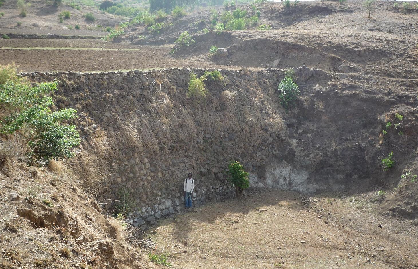
Stone wall check dams are built across a gully to collect alluvial soil and hinder further gully erosion.
2.2 การอธิบายแบบละเอียดของเทคโนโลยี
คำอธิบาย:
During the 1980s stone walls and terraces were introduced in Ethiopia in order to combat soil erosion. The technology of stone walls or terraces is used to stabilize hills or to refill gullies also in Bati, Ethiopia. Stone walls can form a very strong check dam to rehabilitate gullies even several meters deep.
Purpose of the Technology: Although stone walls can be used for different purposes, this case study is focusing on stone walls used to combat gully erosion. Farmers in the Bati region often use stone walls to rehabilitate gullies if the material is easily accessible, otherwise they may search for alternatives.
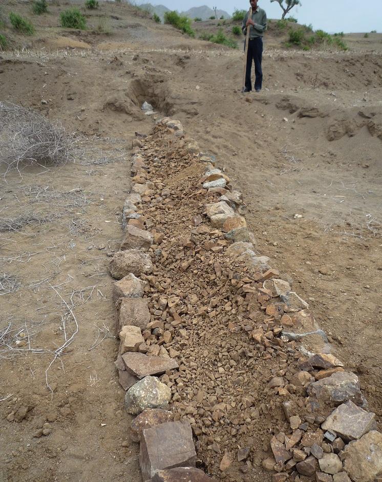
Establishment / maintenance activities and inputs: Following procedure is undertaken to build a stone wall check dam: After breaking the stones in the source-area they are transported to the target-area either by hand, by camels or by donkeys, depending on the distance. After digging a foundation for the wall of approximately 30 cm depth, the gap between two rows of big stones 1 m apart is filled up with smaller stones and gravel. These actions are repeated until the desired height and width of the wall are reached
Natural / human environment: The case study site, Bati, lays in an semiarid climatic zone on 1600 m a.s.l. Rainfalls are erratic and the rain sum per year is between 500-1000 mm. The landscape is very hilly with rather steep slopes. As almost in all Ethiopia, the area has a high population density and growth. The agricultural sector is very dominant and lead by a lot of small scale farming with a lot of livestock and small plots of cropland.
2.3 รูปภาพของเทคโนโลยี
อัลบั้มสื่อบันทึก
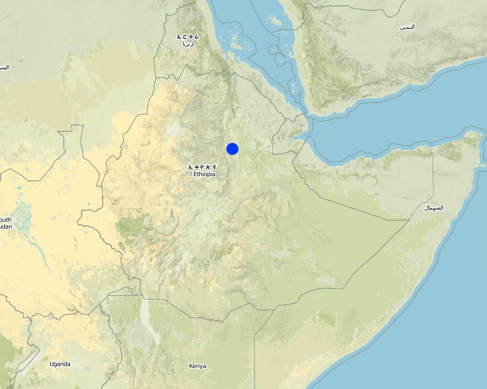
2.5 ประเทศภูมิภาค หรือสถานที่ตั้งที่เทคโนโลยีได้นำไปใช้และได้รับการครอบคลุมโดยการประเมินนี้
ประเทศ:
เอธิโอเปีย
ภูมิภาค/รัฐ/จังหวัด:
Ethiopia / Amhara Region
ข้อมูลจำเพาะเพิ่มเติมของสถานที่ตั้ง :
Bati
แสดงความคิดเห็น:
Total area covered by the SLM Technology is 0.6 km2.
Size of the case study watershed.
Map
×2.6 วันที่การดำเนินการ
ถ้าไม่รู้ปีที่แน่นอน ให้ระบุวันที่โดยประมาณ:
- 10-50 ปี
2.7 คำแนะนำของเทคโนโลยี
ให้ระบุว่าเทคโนโลยีถูกแนะนำเข้ามาอย่างไร:
- ทางโครงการหรือจากภายนอก
ความคิดเห็น (ประเภทของโครงการ เป็นต้น) :
Soil and water conservation measures, including stone wall check dams, were mainly introduced to land users during the 1980s by the government. Sometimes the technology is not adequately performed though. In recent years the local Agricultural Office is teaching farmers how to correctly build soil and water conservation measures not only on a technology basis but to take care of an integrated watershed management.
3. การจัดประเภทของเทคโนโลยี SLM
3.1 วัตถุประสงค์หลักของเทคโนโลยี
- ลด ป้องกัน ฟื้นฟู การเสื่อมโทรมของที่ดิน
3.2 ประเภทของการใช้ที่ดินในปัจจุบันที่ได้นำเทคโนโลยีไปใช้

พื้นที่ปลูกพืช
- การปลูกพืชล้มลุกอายุปีเดียว
Annual cropping - Specify crops:
- cereals - sorghum
- corn
ระบุ:
Longest growing period in days: 90 Longest growing period from month to month: June until September

ทุ่งหญ้าเลี้ยงสัตว์
- Mixed farming
Animal type:
- camels
- cattle - dairy
- goats
- poultry
- sheep
- (Goat/sheep are main meat source (in household or on market))
แสดงความคิดเห็น:
Livestock density (if relevant):
> 100 LU /km2
Major land use problems (compiler’s opinion): Deforestation, overgrazing, cultivation of erosion-sensitive areas or steep slopes.
Major land use problems (land users’ perception): Too much soil loss and land degradation, no vegetation cover and poor soil moisture.
Grazingland comments: Livestock is not fenced in. Children herd the animals and watch out that they do not browse through crop fields. In off-farming season crop residues are collected from the field and stored next to the field. Animals are allowed to eat the still remaining residues on the field. After that, the animals are fed by the collected crop residues.
Livestock is grazing on crop residues
3.4 การใช้น้ำ
การใช้น้ำของที่ดินที่มีการใช้เทคโนโลยีอยู่:
- น้ำฝนร่วมกับการชลประทาน
แสดงความคิดเห็น:
Water supply: Also rainfed
3.5 กลุ่ม SLM ที่ตรงกับเทคโนโลยีนี้
- มาตรการปลูกพืชขวางความลาดชัน (cross-slope measure)
3.6 มาตรการ SLM ที่ประกอบกันเป็นเทคโนโลยี

มาตรการอนุรักษ์ด้วยโครงสร้าง
- S1: คันดิน
- S5: เขื่อน ชั้นดินที่แน่นแข็งบ่อน้ำ
- S6: กำแพง สิ่งกีดขวาง รั้วไม้ รั้วต่างๆ
แสดงความคิดเห็น:
Main measures: structural measures
3.7 รูปแบบหลักของการเสื่อมโทรมของที่ดินที่ได้รับการแก้ไขโดยเทคโนโลยี

การกัดกร่อนของดินโดยน้ำ
- Wt (Loss of topsoil): การสูญเสียดินชั้นบนหรือการกัดกร่อนที่ผิวดิน
- Wg (Gully erosion): การกัดกร่อนแบบร่องธารหรือการทำให้เกิดร่องน้ำเซาะ
แสดงความคิดเห็น:
Main type of degradation addressed: Wg: gully erosion / gullying
Secondary types of degradation addressed: Wt: loss of topsoil / surface erosion
Main causes of degradation: deforestation / removal of natural vegetation (incl. forest fires) (Deforestation for the past 30 years.), over-exploitation of vegetation for domestic use (Wood collection for cooking and construction.), overgrazing (50% of the watershed area are cultivated - big grazing pressure on remaining land), other human induced causes (specify) (Cultivation of very steep slopes.), change of seasonal rainfall (Erratic rainfall.), Heavy / extreme rainfall (intensity/amounts) (If there is rain, it is intensive.), population pressure (High population pressure.), poverty / wealth (Poor facilities.)
Secondary causes of degradation: soil management (Poor soil management practices and lack of awareness.), crop management (annual, perennial, tree/shrub) (Annual cropping.), droughts (The research area is considered rather dry.), land tenure (If the land is rented, it is poorly managed.), inputs and infrastructure: (roads, markets, distribution of water points, other, …) (Poor access to fertilizer. Bad infrastructures.), education, access to knowledge and support services (Lack of awareness for soil degradation.), Low productivity of the land (As a consequence seeking for new/larger areas to increase production.)
3.8 การป้องกัน การลดลง หรือการฟื้นฟูความเสื่อมโทรมของที่ดิน
ระบุเป้าหมายของเทคโนโลยีกับความเสื่อมโทรมของที่ดิน:
- ลดความเสื่อมโทรมของดิน
- ฟื้นฟูบำบัดที่ดินที่เสื่อมโทรมลงอย่างมาก
แสดงความคิดเห็น:
Secondary goals: mitigation / reduction of land degradation
4. ข้อมูลจำเพาะด้านเทคนิค กิจกรรมการนำไปปฏิบัติใช้ ปัจจัยนำเข้า และค่าใช้จ่าย
4.1 แบบแปลนทางเทคนิคของเทคโนโลยี
ข้อมูลจำเพาะด้านเทคนิค (แบบแปลนทางเทคนิคของเทคโนโลยี):
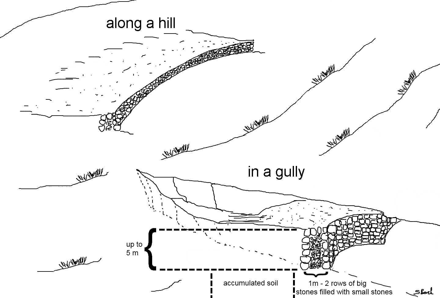
Stone wall check dams as they can be found in the region of Bati. The approximately 1 m wide gap between two rows of larger stones is filled up with small stones or gravel. This is done for every new level of the wall until the wall reaches its final height. The first row of stones is placed in the top 30 cm of the ground and on each side the dam is entering the hill to some extent. After a wall has silted up, the height is increased by other rows of stones until desired dimension is reached. Walls up to 5 m can be found in the case study site.
Location: South-West of Bati. Bati Woreda, Amhara Region, Ethiopia
Date: 26.04.2011
Technical knowledge required for field staff / advisors: moderate (To teach the farmers how to perform an integrated watershed management.)
Technical knowledge required for land users: high (To build a robust check dam there is a lot of knowledge needed.)
Main technical functions: control of concentrated runoff: retain / trap, control of concentrated runoff: impede / retard, reduction of slope angle, reduction of slope length, increase / maintain water stored in soil, sediment retention / trapping, sediment harvesting
Secondary technical functions: water harvesting / increase water supply, improvement of water quality, buffering / filtering water
Retention/infiltration ditch/pit, sediment/sand trap
Depth of ditches/pits/dams (m): 6
Width of ditches/pits/dams (m): 10
Length of ditches/pits/dams (m): 1
If the original slope has changed as a result of the Technology, the slope today is: 0%
ผู้เขียน:
Simon Bach, CDE, Bern, Switzerland
4.2 ข้อมูลทั่วไปเกี่ยวกับการคำนวณปัจจัยนำเข้าและค่าใช้จ่าย
อื่นๆ หรือสกุลเงินประจำชาติ (ระบุ):
Ethiopian Birr
If relevant, indicate exchange rate from USD to local currency (e.g. 1 USD = 79.9 Brazilian Real): 1 USD =:
16.82
ระบุค่าเฉลี่ยของค่าจ้างในการจ้างแรงงานต่อวัน:
1.00
4.3 กิจกรรมเพื่อการจัดตั้ง
| กิจกรรม | Timing (season) | |
|---|---|---|
| 1. | Preparation of the stones (500 person days needed). | During dry season. |
| 2. | Transportation of the stones (depending on the distance). | During dry season. |
| 3. | Digging a foundation of 30 cm depth (165 person days needed). | During dry season. |
| 4. | Building of the stone wall (500 person days needed). | During dry season. |
4.4 ค่าใช้จ่ายของปัจจัยนำเข้าที่จำเป็นสำหรับการจัดตั้ง
| ปัจจัยนำเข้า | หน่วย | ปริมาณ | ค่าใช้จ่ายต่อหน่วย | ค่าใช้จ่ายทั้งหมดต่อปัจจัยนำเข้า | %ของค่าใช้จ่ายที่ก่อให้เกิดขึ้นโดยผู้ใช้ที่ดิน | |
|---|---|---|---|---|---|---|
| แรงงาน | Labour | ha | 1.0 | 1165.0 | 1165.0 | 50.0 |
| อุปกรณ์ | Tools | ha | 1.0 | 5.0 | 5.0 | 100.0 |
| ค่าใช้จ่ายทั้งหมดของการจัดตั้งเทคโนโลยี | 1170.0 | |||||
| Total costs for establishment of the Technology in USD | 69.56 | |||||
4.5 การบำรุงรักษาสภาพหรือกิจกรรมที่เกิดขึ้นเป็นประจำ
| กิจกรรม | ช่วงระยะเวลา/ความถี่ | |
|---|---|---|
| 1. | Prepare the stones (250 person days needed). | During dry season if needed. |
| 2. | If dam is silted up, increasing the height by 0.5 m (250 person days needed) | Every year in dry season. |
4.6 ค่าใช้จ่ายของปัจจัยนำเข้าและกิจกรรมที่เกิดขึ้นเป็นประจำที่ต้องการการบำรุงรักษา (ต่อปี)
| ปัจจัยนำเข้า | หน่วย | ปริมาณ | ค่าใช้จ่ายต่อหน่วย | ค่าใช้จ่ายทั้งหมดต่อปัจจัยนำเข้า | %ของค่าใช้จ่ายที่ก่อให้เกิดขึ้นโดยผู้ใช้ที่ดิน | |
|---|---|---|---|---|---|---|
| แรงงาน | Labour | ha | 1.0 | 500.0 | 500.0 | 50.0 |
| อุปกรณ์ | Tools | ha | 1.0 | 5.0 | 5.0 | 100.0 |
| ค่าใช้จ่ายทั้งหมดของการบำรุงรักษาสภาพเทคโนโลยี | 505.0 | |||||
| Total costs for maintenance of the Technology in USD | 30.02 | |||||
แสดงความคิดเห็น:
Machinery/ tools: Shovel, digging hoe, iron rod.
Total costs of a hectare were calculated for a wall of 100 m length and 1 m of height every 20 m (500 m total wall) in the year 2011. Tool prices were estimated and labor costs were calculated with a daily wage of 1$.
4.7 ปัจจัยสำคัญที่สุดที่มีผลกระทบต่อค่าใช้จ่าย
ปัจจัยสำคัญที่สุดที่มีผลกระทบต่อค่าใช้จ่ายต่างๆ:
Rough topology in the area, questionable availability of construction materials if they are not found nearby.
5. สิ่งแวดล้อมทางธรรมชาติและของมนุษย์
5.1 ภูมิอากาศ
ฝนประจำปี
- < 250 ม.ม.
- 251-500 ม.ม.
- 501-750 ม.ม.
- 751-1,000 ม.ม.
- 1,001-1,500 ม.ม.
- 1,501-2,000 ม.ม.
- 2,001-3,000 ม.ม.
- 3,001-4,000 ม.ม.
- > 4,000 ม.ม.
ข้อมูลจำเพาะ/ความคิดเห็นเรื่องปริมาณน้ำฝน:
Erratic rainfall (rainseason from June until September)
เขตภูมิอากาศเกษตร
- กึ่งแห้งแล้ง
Thermal climate class: tropics (LGP shorter than 90 days.)
5.2 สภาพภูมิประเทศ
ค่าเฉลี่ยความลาดชัน:
- ราบเรียบ (0-2%)
- ลาดที่ไม่ชัน (3-5%)
- ปานกลาง (6-10%)
- เป็นลูกคลื่น (11-15%)
- เป็นเนิน (16-30%)
- ชัน (31-60%)
- ชันมาก (>60%)
ธรณีสัณฐาน:
- ที่ราบสูง/ที่ราบ
- สันเขา
- ไหล่เขา
- ไหล่เนินเขา
- ตีนเนิน
- หุบเขา
ระดับความสูง:
- 0-100 เมตร
- 101-500 เมตร
- 501-1,000 เมตร
- 1,001-1,500 เมตร
- 1,501-2,000 เมตร
- 2,001-2,500 เมตร
- 2,501-3,000 เมตร
- 3,001-4,000 เมตร
- > 4,000 เมตร
ความคิดเห็นและข้อมูลจำเพาะเพิ่มเติมเรื่องสภาพภูมิประเทศ:
Altitudinal zone: 1501-2000 m a.s.l. (The study site is located at 1600m a.s.l.)
Landforms: Hill slopes (ranked 1) and valley floors (ranked 2)
Slopes on average: Hilly (ranked 1), rolling (ranked 2) and steep (ranked 3)
5.3 ดิน
ค่าเฉลี่ยความลึกของดิน:
- ตื้นมาก (0-20 ซ.ม.)
- ตื้น (21-50 ซ.ม.)
- ลึกปานกลาง (51-80 ซ.ม.)
- ลึก (81-120 ซ.ม.)
- ลึกมาก (>120 ซ.ม.)
เนื้อดิน (ดินชั้นบน):
- หยาบ/เบา (ดินทราย)
- ปานกลาง (ดินร่วน ทรายแป้ง)
อินทรียวัตถุในดิน:
- ต่ำ (<1%)
(ถ้ามี) ให้แนบคำอธิบายเรื่องดินแบบเต็มหรือระบุข้อมูลที่มีอยู่ เช่น ชนิดของดิน ค่า pH ของดินหรือความเป็นกรดของดิน ความสามารถในการแลกเปลี่ยนประจุบวก ไนโตรเจน ความเค็ม เป็นต้น:
Soil depth on average: Very shallow (ranked 1) and shallow (ranked 2)
Soil textur: Coarse/light (ranked 1) and medium (ranked 2)
Soil fertility is low
Soil drainage/infiltration is poor
Soil water storage capacity is medium
5.4 ความเป็นประโยชน์และคุณภาพของน้ำ
ระดับน้ำใต้ดิน:
5-50 เมตร
น้ำไหลบ่าที่ผิวดิน:
ไม่ดีหรือไม่มีเลย
คุณภาพน้ำ (ที่ยังไม่ได้บำบัด):
เป็นน้ำเพื่อการดื่มที่ไม่ดี (จำเป็นต้องได้รับการบำบัด)
ความคิดเห็นและข้อมูลจำเพาะเพิ่มเติมเรื่องคุณภาพและปริมาณน้ำ:
Ground water table: Unknown
Availability of surface water is poor/none (Only during rainy season)
Water quality (untreated): Poor drinking water (treatment required, mostly groundwater)
5.5 ความหลากหลายทางชีวภาพ
ความหลากหลายทางชนิดพันธุ์:
- ต่ำ
ความคิดเห็นและข้อมูลจำเพาะเพิ่มเติมของความหลากหลายทางชีวภาพ:
Relative to other parts of Ethiopia.
5.6 ลักษณะของผู้ใช้ที่ดินที่นำเทคโนโลยีไปปฏิบัติใช้
แนวทางการตลาดของระบบการผลิต:
- เพื่อการยังชีพ (หาเลี้ยงตนเอง)
รายได้ที่มาจากนอกฟาร์ม:
- < 10% ของรายได้ทั้งหมด
ระดับของความมั่งคั่งโดยเปรียบเทียบ:
- รวย
เป็นรายบุคคล/ครัวเรือน:
- เป็นรายบุคคล/ครัวเรือน
ระดับของการใช้เครื่องจักรกล:
- งานที่ใช้แรงกาย
- การใช้กำลังจากสัตว์
เพศ:
- ชาย
ระบุลักษณะอื่นๆที่เกี่ยวข้องของผู้ใช้ที่ดิน:
Land users applying the Technology are mainly common / average land users
Population density: 100-200 persons/km2
Annual population growth: 6%
1% of the land users are rich (Adopt the most of SWC technologies).
19% of the land users are average wealthy.
89% of the land users are poor.
Off-farm income specification: Off-farm income has low importance.
Level of mechanization: Animal traction (Plowing by oxen, ranked 1) and manual labour (ranked 2)
Market orientation cropland: Subsistence
Market orientation grazing land: Goat/sheep are main meat source (in household or on market).
5.7 Average area of land used by land users applying the Technology
- < 0.5 เฮกตาร์
- 0.5-1 เฮกตาร์
- 1-2 เฮกตาร์
- 2-5 เฮกตาร์
- 5-15 เฮกตาร์
- 15-50 เฮกตาร์
- 50-100 เฮกตาร์
- 100-500 เฮกตาร์
- 500-1,000 เฮกตาร์
- 1,000-10,000 เฮกตาร์
- >10,000 เฮกตาร์
พิจารณาว่าเป็นขนาดเล็ก กลาง หรือขนาดใหญ่ (ซึ่งอ้างอิงถึงบริบทระดับท้องถิ่น):
- ขนาดเล็ก
5.8 กรรมสิทธิ์ในที่ดิน สิทธิในการใช้ที่ดินและสิทธิในการใช้น้ำ
กรรมสิทธิ์ในที่ดิน:
- รายบุคคล ได้รับสิทธิครอบครอง
สิทธิในการใช้น้ำ:
- เข้าถึงได้แบบเปิด (ไม่ได้จัดระเบียบ)
5.9 การเข้าถึงบริการและโครงสร้างพื้นฐาน
สุขภาพ:
- จน
- ปานกลาง
- ดี
การศึกษา:
- จน
- ปานกลาง
- ดี
ความช่วยเหลือทางด้านเทคนิค:
- จน
- ปานกลาง
- ดี
การจ้างงาน (เช่น ภายนอกฟาร์ม):
- จน
- ปานกลาง
- ดี
ตลาด:
- จน
- ปานกลาง
- ดี
พลังงาน:
- จน
- ปานกลาง
- ดี
ถนนและการขนส่ง:
- จน
- ปานกลาง
- ดี
น้ำดื่มและการสุขาภิบาล:
- จน
- ปานกลาง
- ดี
บริการด้านการเงิน:
- จน
- ปานกลาง
- ดี
6. ผลกระทบและสรุปคำบอกกล่าว
6.1 ผลกระทบในพื้นที่ดำเนินการ (On-site) จากการใช้เทคโนโลยี
ผลกระทบทางด้านเศรษฐกิจและสังคม
การผลิต
การผลิตพืชผล
การผลิตสัตว์
การเสี่ยงต่อความล้มเหลวในการผลิต
แสดงความคิดเห็น/ระบุ:
Conservation of soil water
พื้นที่สำหรับการผลิต
แสดงความคิดเห็น/ระบุ:
Gullies are transformed to fields. Structure needs space but also gains space
การจัดการที่ดิน
แสดงความคิดเห็น/ระบุ:
Structure as a new obstacle
ความเป็นประโยชน์และคุณภาพของน้ำ
การมีน้ำดื่มไว้ให้ใช้
รายได้และค่าใช้จ่าย
ค่าใช่จ่ายของปัจจัยการผลิตทางการเกษตร
แสดงความคิดเห็น/ระบุ:
alluvial soil is relatively fertile
รายได้จากฟาร์ม
แสดงความคิดเห็น/ระบุ:
new fields lead to higher productivity
ความหลากหลายของแหล่งผลิตรายได้
ความเหลื่อมล้ำทางเศรษฐกิจ
แสดงความคิดเห็น/ระบุ:
additional income due to new fields
ภาระงาน
แสดงความคิดเห็น/ระบุ:
Gully is now flat land and traversable but needs establishment and maintenance work
ผลกระทบด้านสังคมวัฒนธรรมอื่น ๆ
ความมั่นคงด้านอาหาร / พึ่งตนเองได้
แสดงความคิดเห็น/ระบุ:
Additional space for new fields
สถาบันของชุมชน
สถาบันแห่งชาติ
SLM หรือความรู้เรื่องความเสื่อมโทรมของที่ดิน
แสดงความคิดเห็น/ระบุ:
best practices may spread further on
การบรรเทาความขัดแย้ง
แสดงความคิดเห็น/ระบุ:
upstream and downstream dialog
Improved livelihoods and human well-being
แสดงความคิดเห็น/ระบุ:
Accumulation of soil leads to new space for fields and additional food security or even income (if crop surplus is sold).
ผลกระทบด้านนิเวศวิทยา
วัฐจักรน้ำหรือน้ำบ่า
ปริมาณน้ำ
แสดงความคิดเห็น/ระบุ:
increased soil moisture
การเก็บเกี่ยวหรือการกักเก็บน้ำ
แสดงความคิดเห็น/ระบุ:
dam blocks water flow
น้ำไหลบ่าที่ผิวดิน
แสดงความคิดเห็น/ระบุ:
increased infiltration, reduced flow velocity
น้ำบาดาลหรือระดับน้ำในแอ่งน้ำบาดาล
แสดงความคิดเห็น/ระบุ:
increased infiltration
ดิน
ความชื้นในดิน
แสดงความคิดเห็น/ระบุ:
Dam blocks water flow but can lead to the fact that additional groundwater may be logged
การสูญเสียดิน
แสดงความคิดเห็น/ระบุ:
alluvial accumulation behind the structure
การหมุนเวียนและการเติมของธาตุอาหาร
ความหลากหลายทางชีวภาพของพืชและสัตว์
มวลชีวภาพ/เหนือดินชั้น C
ความหลากหลายทางชีวภาพของพืช
ความหลากหลายทางชีวภาพของสัตว์
ชนิดพันธุ์ที่ให้ประโยชน์
ความหลากหลายของสัตว์
การจัดการศัตรูพืชและโรคพืช
แสดงความคิดเห็น/ระบุ:
new habitat for rodents etc.
ลดความเสี่ยงของภัยพิบัติ
ผลกระทบจากน้ำท่วม
แสดงความคิดเห็น/ระบุ:
flood controll by stone check dams
การปล่อยคาร์บอนและก๊าซเรือนกระจก
6.2 ผลกระทบนอกพื้นที่ดำเนินการ (Off-site) จากการใช้เทคโนโลยี
น้ำที่ใช้ประโยชน์ได้
แสดงความคิดเห็น/ระบุ:
possibility of spring development
การไหลของน้ำคงที่และสม่ำเสมอในช่วงฤดูแล้ง
แสดงความคิดเห็น/ระบุ:
if a spring can develop
น้ำท่วมพื้นที่ท้ายน้ำ
แสดงความคิดเห็น/ระบุ:
increased infiltration/reduced flooding but also less downstream river flow
การทับถมของดินตะกอนพื้นที่ท้ายน้ำ
แสดงความคิดเห็น/ระบุ:
trapping of the sediments by the structure
การเกิดมลพิษในน้ำบาดาลหรือแม่น้ำ
แสดงความคิดเห็น/ระบุ:
trapping of the sediments by the structure. No off site sediment yields available anymore.
ความสามารถต้านทานการเปลี่ยนแปลง / ความสามารถในการคัดกรอง
แสดงความคิดเห็น/ระบุ:
increased infiltration
ตะกอนที่ถูกพัดพามาโดยลม
ความเสียหายต่อพื้นที่เพาะปลูกของเพื่อนบ้าน
แสดงความคิดเห็น/ระบุ:
due to gully rehabilitation
ความเสียหายต่อโครงสร้างพื้นฐานของรัฐหรือของเอกชน
แสดงความคิดเห็น/ระบุ:
due to gully rehabilitation
6.3 การเผชิญและความตอบสนองของเทคโนโลยีต่อการเปลี่ยนแปลงสภาพภูมิอากาศที่ค่อยเป็นค่อยไป และสภาพรุนแรงของภูมิอากาศ / ภัยพิบัติ (ที่รับรู้ได้โดยผู้ใช้ที่ดิน)
การเปลี่ยนแปลงสภาพภูมิอากาศที่ค่อยเป็นค่อยไป
การเปลี่ยนแปลงสภาพภูมิอากาศที่ค่อยเป็นค่อยไป
| ฤดู | increase or decrease | เทคโนโลยีมีวิธีการรับมืออย่างไร | |
|---|---|---|---|
| อุณหภูมิประจำปี | เพิ่มขึ้น | ดี |
สภาพรุนแรงของภูมิอากาศ (ภัยพิบัติ)
ภัยพิบัติทางอุตุนิยมวิทยา
| เทคโนโลยีมีวิธีการรับมืออย่างไร | |
|---|---|
| พายุฝนประจำท้องถิ่น | ดี |
| พายุลมประจำท้องถิ่น | ดี |
ภัยพิบัติจากสภาพภูมิอากาศ
| เทคโนโลยีมีวิธีการรับมืออย่างไร | |
|---|---|
| ภัยจากฝนแล้ง | ดี |
ภัยพิบัติจากน้ำ
| เทคโนโลยีมีวิธีการรับมืออย่างไร | |
|---|---|
| น้ำท่วมตามปกติ (แม่น้ำ) | ดี |
ผลลัพธ์ตามมาที่เกี่ยวข้องกับภูมิอากาศอื่น ๆ
ผลลัพธ์ตามมาที่เกี่ยวข้องกับภูมิอากาศอื่น ๆ
| เทคโนโลยีมีวิธีการรับมืออย่างไร | |
|---|---|
| ช่วงการปลูกพืชที่ลดลงมา | ดี |
6.4 การวิเคราะห์ค่าใช้จ่ายและผลประโยชน์ที่ได้รับ
ผลประโยชน์ที่ได้รับเปรียบเทียบกับค่าใช้จ่ายในการจัดตั้งเป็นอย่างไร (จากมุมมองของผู้ใช้ที่ดิน)
ผลตอบแทนระยะสั้น:
ด้านลบอย่างมาก
ผลตอบแทนระยะยาว:
ด้านบวก
ผลประโยชน์ที่ได้รับเปรียบเทียบกับค่าใช้จ่ายในการบำรุงรักษาหรือต้นทุนที่เกิดขึ้นซ้ำอีก เป็นอย่างไร (จากมุมมองของผู้ใช้ที่ดิน)
ผลตอบแทนระยะสั้น:
ด้านลบเล็กน้อย
ผลตอบแทนระยะยาว:
ด้านบวก
แสดงความคิดเห็น:
Big labour input for establishment. Also maintenance needs some work every year. But also high benefit by additional farming land gained due to the check dams.
6.5 การปรับตัวของเทคโนโลยี
แสดงความคิดเห็น:
100% of land user families have adopted the Technology with external material support
Comments on acceptance with external material support: In the past 6 years the local Agricultural Office has supported farmers to treat their watersheds with SWC technologies based on a food for work programme. Today farmers build the structures on their own but seek support.
There is a moderate trend towards spontaneous adoption of the Technology
Comments on adoption trend: Most of the farmers build SWC technologies (includin stone check dams in gullies) because of the food for work programme
6.7 จุดแข็ง / ข้อได้เปรียบ / โอกาสของเทคโนโลยี
| จุดแข็ง / ข้อได้เปรียบ / โอกาสในทัศนคติของผู้ใช้ที่ดิน |
|---|
|
The stone check dams are conserving soil and moisture. How can they be sustained / enhanced? Maintain the dams. |
|
Due to alluvial soil there is additional farming land and therefore increased productivity. How can they be sustained / enhanced? Take care of the walls as well of the surrounding area and the whole watershed. |
| จุดแข็ง / ข้อได้เปรียบ / โอกาสในทัศนคติของผู้รวบรวมหรือวิทยากรหลัก |
|---|
|
Stone check dams are a quite durable structure. How can they be sustained / enhanced? Stability could be enhanced by additional technologies e.g. similar as gabbions or planting of trees/shrubs in front of the wall to reduce collapsing possibility. |
|
The structure collects alluvial soil which can be plowed and used as new farming fields. How can they be sustained / enhanced? Structure maintenance is important. If the dam fails, the field is washed out as well. |
|
The technology is widely used around the world (perhaps with local adaptations) and is therefore well documented. How can they be sustained / enhanced? Keep on with documentation and monitoring of limitations and potentials of stone check dams around the world. |
6.8 จุดอ่อน / ข้อเสียเปรียบ / ความเสี่ยงของเทคโนโลยีและวิธีการแก้ไข
| จุดอ่อน / ข้อเสียเปรียบ / ความเสี่ยงในทัศนคติของผู้ใช้ที่ดิน | มีวิธีการแก้ไขได้อย่างไร |
|---|---|
| The Land users could not tell any disadvantages of the technology. | Could be an indicator that there is enough spare time to build and maintain structures during off-farming season. |
| จุดอ่อน / ข้อเสียเปรียบ / ความเสี่ยงในทัศนคติของผู้รวบรวมหรือวิทยากรหลัก | มีวิธีการแก้ไขได้อย่างไร |
|---|---|
| Large labour input at establishment and during maintenance period. | Possibly by machinery but it is very expensive. |
| During time of establishment/maintenance there is no time for farming activites. These activities can therefore be seen as hidden costs. | Perhaps a "professional" team that takes care of check dams and is payed for it. |
7. การอ้างอิงและการเชื่อมต่อ
7.1 วิธีการและแหล่งข้อมูล
7.2 การอ้างอิงถึงสิ่งตีพิมพ์
หัวข้อ, ผู้เขียน, ปี, หมายเลข ISBN:
Bach S. (2012) Potentials and limitations of Jatropha curcas as a multipurpose crop for sustainable energy supply and soil and water conservation - a case study in Bati, Ethiopia, using the WOCAT approach. Unpublished master’s thesis, Centre for Development and Environment, University of Bern.
ลิงก์และโมดูล
ขยายทั้งหมด ย่อทั้งหมดลิงก์
ไม่มีลิงก์
โมดูล
ไม่มีโมดูล