Rehabilitation of degraded land [សាធារណរដ្ឋម៉ុលដាវី]
- ការបង្កើត៖
- បច្ចុប្បន្នភាព
- អ្នកចងក្រង៖ Valentin Ciubotaru
- អ្នកកែសម្រួល៖ Valentin Ciubotaru, UNCCD PRAIS
- អ្នកត្រួតពិនិត្យច្រើនទៀត៖ Farrukh Nazarmavloev, William Critchley, Rima Mekdaschi Studer
Reabilitarea pamanturilor degradate
technologies_1819 - សាធារណរដ្ឋម៉ុលដាវី
ពិនិត្យមើលគ្រប់ផ្នែក
ពង្រីកមើលទាំងអស់ បង្រួមទាំងអស់1. ព័ត៌មានទូទៅ
1.2 ព័ត៌មានលម្អិតពីបុគ្គលសំខាន់ៗ និងស្ថាប័នដែលចូលរួមក្នុងការវាយតម្លៃ និងចងក្រងឯកសារនៃបច្ចេកទេស
បុគ្គលសំខាន់ម្នាក់ (ច្រើននាក់)
អ្នកជំនាញឯកទេស SLM:
1.3 លក្ខខណ្ឌទាក់ទងទៅនឹងការប្រើប្រាស់ទិន្នន័យដែលបានចងក្រងតាមរយៈ វ៉ូខេត
តើពេលណាដែលទិន្នន័យបានចងក្រង (នៅទីវាល)?
02/06/2014
អ្នកចងក្រង និង(បុគ្គលសំខាន់ៗ)យល់ព្រមទទួលយកនូវលក្ខខណ្ឌនានាទាក់ទងទៅនឹងការប្រើប្រាស់ទិន្នន័យដែលបានចងក្រងតាមរយៈវ៉ូខេត:
បាទ/ចា៎
1.4 សេចក្តីប្រកាសស្តីពីចីរភាពនៃការពណ៌នាពីបច្ចេកទេស
តើបច្ចេកទេសដែលបានពណ៌នានេះមានបញ្ហាដែលផ្តោតលើការធ្លាក់ចុះគុណភាពដី, បើដូច្នេះវាមិនអាចត្រូវបានប្រកាសថាជាបច្ចេកទេសនៃការគ្រប់គ្រងប្រកបដោយចីរភាពទេ?
ទេ
មតិយោបល់:
The technology described here is sustainable land management
2. ការពណ៌នាពីបច្ចេកទេស SLM
2.1 ការពណ៌នាដោយសង្ខេបពីបច្ចេកទេស
និយមន័យបច្ចេកទេស:
Participatory land management was used to develop, and implement, SLM practices on slopes in order to rehabilitate degraded land. The local population were involved from the beginning. They took part in soil, water and biodiversity research, as well as the formulation and implementation of the land management plan, based on suitable SLM practices. In order to benefit from local knowledge, participatory training included traditional experience in soil conservation, and based on this, appropriate SLM technologies were included in the plan of action.
2.2 ការពណ៌នាលម្អិតពីបច្ចេកទេស
ការពណ៌នា:
The distinctive feature of this approach to rehabilitating degraded land on slopes was the involvement of the local population from the beginning. They took part in soil, water and biodiversity research, as well as the development and implementation of the land management plan, based on suitable SLM practices. In order to benefit from local knowledge, participatory training included traditional experience in soil conservation, and based on this, appropriate SLM technologies were included in the plan of action.
The following stakeholders were involved in the overall process:
• Researchers: overseeing soil, water and biodiversity research and presenting results.
• Experts: proposing alternatives in the organization of the land and in the development of integrated management system for the landscape based on research results.
• Local public administration, Joint Stock Company and farmers: contributing with knowledge and experience in analysing land, water and biodiversity resources, preparation and implementation of the action plan.
• NGO BIOS: coordinating all activities, including research, implementation, training and monitoring of activities.
The land management plan was developed together with the local population, then it was implemented. Degraded areas (landslides and heavily eroded soils) were excluded from agricultural production and used for afforestation and grassland. The following soil and water conservation practices are applied:
Vineyards and orchards:
• Conservation tillage
• Forest belts
• Grass inter-rows in vineyards and orchards
Arable land:
• Crop rotation
• Application of mineral and organic fertilizers
• Strip cropping
• Conservation tillage,
• Forest belts.
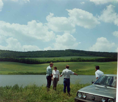
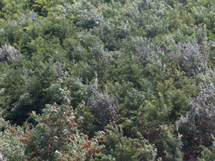
2.3 រូបភាពនៃបច្ចេកទេស
វិចិត្រសាលប្រព័ន្ធផ្សព្វផ្សាយ
2.5 ប្រទេស/តំបន់/ទីតាំងកន្លែង ដែលបច្ចេកទេសត្រូវបានអនុវត្ត និងបានគ្រប់ដណ្តប់ដោយការវាយតម្លៃនេះ
ប្រទេស:
សាធារណរដ្ឋម៉ុលដាវី
តំបន់/រដ្ឋ/ខេត្ត:
Central Region of the Republic of Moldova
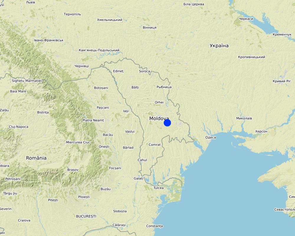
Map
×2.6 កាលបរិច្ឆេទនៃការអនុវត្ត
បង្ហាញឆ្នាំនៃការចុះអនុវត្ត:
1998
ប្រសិនបើមិនច្បាស់ឆ្នាំ សូមបញ្ជាក់កាលបរិច្ឆេទដែលប្រហាក់ប្រហែល:
- 10-50 ឆ្នាំ
2.7 ការណែនាំពីបច្ចេកទេស
សូមបញ្ជាក់តើបច្ចេកទេសត្រូវបានណែនាំឱ្យអនុវត្តដោយរបៀបណា:
- តាមរយៈគម្រោង / អន្តរាគមន៍ពីខាងក្រៅ
3. ចំណាត់ថ្នាក់នៃបច្ចេកទេស SLM
3.1 គោលបំណងចម្បង (១ ឬច្រើន) នៃបច្ចេកទេសនេះ
- កាត់បន្ថយ, បង្ការ, ស្តារឡើងវិញនូវការធ្លាក់ចុះគុណភាពដី
- ការពារតំបន់ទីជម្រាល/តំបន់ខ្សែទឹកខាងក្រោមបញ្ចូលជាមួយបច្ចេកទេសផ្សេងទៀត
3.2 ប្រភេទដីប្រើប្រាស់មួយប្រភេទ (ច្រើនប្រភេទ) ដែលបានអនុវត្តបច្ចេកទេស

ដីដាំដំណាំ
- ដំណាំប្រចាំឆ្នាំ
- ប្រភេទដើមឈើធំៗ និងដើមឈើតូចៗ
ដំណាំចម្បង (ដំណាំកសិ-ឧស្សាហកម្ម និងដំណាំស្បៀង) :
Vineyards, wheat, barley, maize, sunflower.

ដីព្រៃ/ដីដាំដើមឈើ
ព្រៃ (ពាក់កណ្តាល) ធម្មជាតិ/ ដីព្រៃ:
- កាប់តែមួយចំនួន
ការដាំដើមឈើ ការដាំព្រៃឡើងវិញ:
- ពូជបញ្ចូលគ្នា
ផលិតផល និងសេវាកម្ម:
- អុស
- ផ្លែឈើ និងគ្រាប់ធញ្ញជាតិ
- វាលស្មៅ
- ការអភិរក្ស/ការការពារធម្មជាតិ
- ការកំសាន្ត/ទេសចរណ៍
ប្រសិនបើដីមានការប្រែប្រួលបន្ទាប់ពីការអនុវត្តបច្ចេកទេស សូមបញ្ជាក់ពីការប្រើប្រាស់ដីមុនពេលអនុវត្តន៍បច្ចេកទេស:
About 150 ha of degraded land (landslides) were taken out of agricultural production and transferred to afforestation
3.3 ព័ត៌មានបន្ថែមអំពីអ្នកប្រើប្រាស់ដី
ការផ្គត់ផ្គង់ទឹកនៅកន្លែងអនុវត្តបច្ចេកទេស:
- ទឹកភ្លៀង
ចំនួនសារដែលដាំដំណាំក្នុងមួយឆ្នាំ:
- 1
3.4 ក្រុម SLM ដែលបច្ចេកទេសស្ថិតនៅក្នុង
- ប្រព័ន្ធដំណាំបង្វិល (ការដាំដំណាំវិលជុំ ការទុកដីចោលដើម្បីបង្កើនជីជាតិ កសិកម្មពនេចរ)
- ការគ្រប់គ្រងជីជាតិដីតាមបែបចម្រុះ
- បញ្ចូលការគ្រប់គ្រងសត្វល្អិត និងជំងឺតាមបែបចម្រុះ (រួមទាំង កសិកម្មសរីរាង្គ)
3.5 ការសាយភាយនៃបច្ចេកទេស
បញ្ជាក់ពីការសាយភាយនៃបច្ចេកទេស:
- ត្រូវបានផ្សព្វផ្សាយត្រឹមតំបន់មួយ
ប្រសិនបើបច្ចេកទេសត្រូវបានសាយភាយពាសពេញតំបន់ណាមួយ សូមកំណត់ទំហំផ្ទៃដីអនុវត្តន៍:
- 100-1,000 គម2
3.6 វិធានការ SLM ដែលបញ្ចូលនូវបច្ចេកទេស

វិធានការក្សេត្រសាស្ត្រ
- A1: ដំណាំ/គម្របដី
- A2: សារធាតុសរីរាង្គ/ជីជាតិដី

វិធានការរុក្ខជាតិ
- V1: ឈើធំៗ និងដើមឈើតូចៗ
- V2: ស្មៅនិងរុក្ខជាតិៗដែលដុះមានអាយុមិនលើសពី 2ឆ្នាំ
- V3: ការកាប់ឆ្ការរុក្ខជាតិ
- V4: ការជំនួស ឬការយកចេញនៃប្រភេទរុក្ខជាតិក្រៅស្រុក/ ការរាតត្បាត

វិធានការរចនាស័ម្ពន្ធ
- S3: កម្ពស់ភ្លឺ ប្រឡាយ ផ្លូវទឹក
- S5: ទំនប់ ថ្លុក ស្រះ
- S6: ជញ្ជាំង, របាំង, របងឈើខ្ពស់ៗ

វិធានការគ្រប់គ្រង
- M1: ការផ្លាស់ប្តូរប្រភេទដីប្រើប្រាស់
- M6: ការគ្រប់គ្រងសំណល់ (កែឆ្នៃទ្បើងវិញ ប្រើប្រាស់ឡើងវិញ ឬបន្ថយការប្រើប្រាស់)
3.7 កំណត់ប្រភេទនៃការធ្លាក់ចុះគុណភាពដីសំខាន់ៗដែលបច្ចេកទេសនេះបានដោះស្រាយ

ការហូរច្រោះដីដោយសារទឹក
- Wt: ការបាត់ដីស្រទាប់លើដោយការហូរច្រោះ
- Wg: ការកកើតឡើងនូវកំទេចកំទីដីស្រទាប់ក្រោម
- Wm: ការបាក់ដី

ការធ្លាក់ចុះសារធាតុគីមីក្នុងដី

ការធ្លាក់ចុះជីវសាស្ត្រនៃដី
- Bc: ការថយចុះនូវគម្របរុក្ខជាតិ
- Bh: ការបាត់បង់ទីជំរក
- Bq: ការថយចុះនូវជីវម៉ាស/ បរិមាណ
- Bf: ផលប៉ះពាល់ដែលបណ្តាលមកពីភ្លើងឆេះ
- Bs: សមាសភាពដែលមានគុណភាពនិងប្រភេទសត្វ/ការថយចុះនូវជីវចម្រុះ
- Bl: ការបាត់បង់មីក្រូ និងម៉ាក្រូសរីរាង្គរបស់ដី
- Bp: ការកើនឡើងនូវសត្វល្អិត ឬជំងឺ បាត់បង់នូវសត្វមានប្រយោជន៍
3.8 ការពារ កាត់បន្ថយ ឬស្តារឡើងវិញនៃការធ្លាក់ចុះគុណភាពដី
បញ្ជាក់ពីគោលដៅរបស់បច្ចេកទេស ដែលផ្តោតទៅការធ្លាក់ចុះគុណភាពដី:
- ការការពារការធ្លាក់ចុះគុណភាពដី
- ការកាត់បន្ថយការធ្លាក់ចុះគុណភាពដី
4. បច្ចេកទេសជាក់លាក់ សកម្មភាពអនុវត្ត ធាតុចូល និងថ្លៃដើម
4.1 គំនូសបច្ចេកទេសនៃបច្ចេកទេសនេះ
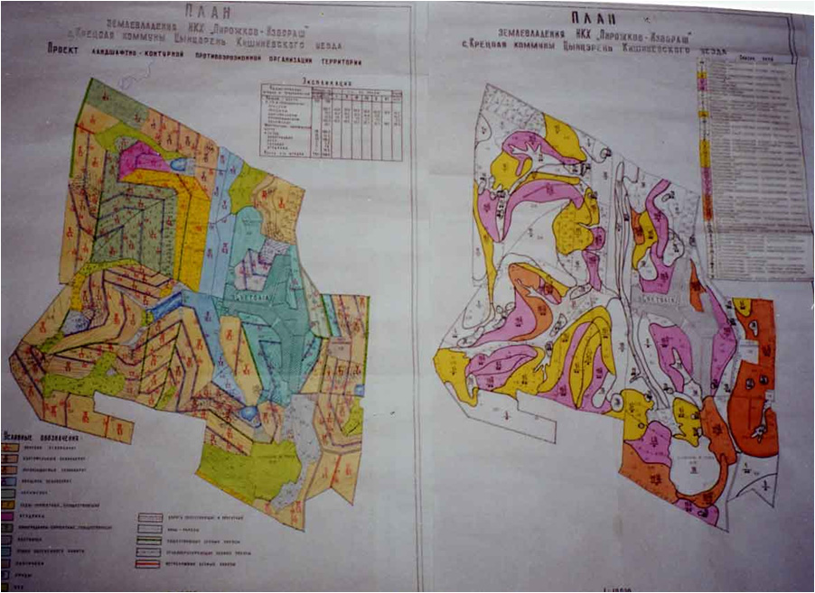
ឈ្មោះអ្នកនិពន្ធ:
Capus, Institute for Territory Planning "Ghiprozem"
កាលបរិច្ឆេទ:
01/06/2008
4.4 សកម្មភាពបង្កើត
| សកម្មភាព | ប្រភេទវិធានការ | ពេលវេលា | |
|---|---|---|---|
| 1. | Regeneration of degraded commune forest as well as existing forest protective belts | ||
| 2. | Soil conservation tillage | ||
| 3. | Planting of grass in inter raw of vineyards and orchards together with contour tillage and other soil conservation | ||
| 4. | Earth dam structure |
5. លក្ខណៈបរិស្ថានធម្មជាតិ និងមនុស្ស
5.1 អាកាសធាតុ
បរិមាណទឹកភ្លៀងប្រចាំឆ្នាំ
- < 250 មម
- 251-500 មម
- 501-750 មម
- 751-1,000 មម
- 1,001-1,500 មម
- 1,501-2,000 មម
- 2,001-3,000 មម
- 3,001-4,000 មម
- > 4,000 មម
កំណត់បរិមាណទឹកភ្លៀង (បើដឹង) ជា មីលីម៉ែត្រ:
550,00
បញ្ជាក់ឈ្មោះឯកសារយោងនៃស្ថានីយឧតុនិយម:
State Hydrometeorological Service
តំបន់កសិអាកាសធាតុ
- មានភ្លៀងមធ្យម
The climate is moderately continental: the summers are warm and long, with temperatures averaging about 20°C, and the winters are relatively mild and dry, with January temperatures averaging -4°C. Annual rainfall, which ranges from around 500 millimetres; long dry spells are not unusual. The heaviest rainfall occurs in summer; heavy showers and thunderstorms are common.
5.2 សណ្ឋានដី
ជម្រាលជាមធ្យម:
- រាបស្មើ (0-2%)
- ជម្រាលតិចតួច (3-5%)
- មធ្យម (6-10%)
- ជម្រាលខ្ពស់បន្តិច (11-15%)
- ទីទួល (16-30%)
- ទីទួលចោត (31-60%)
- ទីទួលចោតខ្លាំង (>60%)
ទម្រង់ដី:
- ខ្ពង់រាប
- កំពូលភ្នំ
- ជម្រាលភ្នំ
- ជម្រាលទួល
- ជម្រាលជើងភ្នំ
- បាតជ្រលងភ្នំ
តំបន់តាមរយៈកម្ពស់ :
- 0-100 ម
- 101-500 ម
- 501-1,000 ម
- 1,001-1,500 ម
- 1,501-2,000 ម
- 2,001-2,500 ម
- 2,501-3,000 ម
- 3,001-4,000 ម
- > 4,000 ម
មតិយោបល់ និងបញ្ចាក់បន្ថែមអំពីសណ្ឋានដី :
The territory of Cretoaia village is situated in the Central Moldavian Plateau, at an average elevation of about 350 m. It is interlaced by deep, flat valleys, ravines, and landslide-scoured depressions.|
5.3 ដី
ជម្រៅដីជាមធ្យម:
- រាក់ខ្លាំង (0-20 សម)
- រាក់ (21-50 សម)
- មធ្យម (51-80 សម)
- ជ្រៅ (81-120 សម)
- ជ្រៅខ្លាំង (> 120 សម)
វាយនភាពដី (ស្រទាប់លើ):
- មធ្យម (ល្បាយ, ល្បាប់)
វាយនភាពដី (> 20 សម ស្រទាប់ក្នុង):
- មធ្យម (ល្បាយ, ល្បាប់)
សារធាតុសរីរាង្គនៅស្រទាប់ដីខាងលើ:
- មធ្យម (1-3%)
បើអាចសូមភ្ជាប់ការពណ៌នាពីដីឱ្យបានច្បាស់ ឬព័ត៌មានដែលអាចទទួលបាន ឧ. ប្រភេទដី, pH ដី/ ជាតិអាស៊ីត, សមត្ថភាពផ្លាស់ប្តូរកាចុង, វត្តមាននីត្រូសែន, ភាពប្រៃ ។ល។:
Chernozems (black soils) prevail (80% of the area), however they are degraded. About 50% of the land has a gradient from 2 to 6 degrees, while 30% of the land has an inclination exceeding 6 degree. Water erosion processes are widespread and quite intense. The predominant length of the hillsides in Cretoaia is over 900 m.
5.4 ទឹកដែលអាចទាញមកប្រើប្រាស់បាន និងគុណភាពទឹក
នីវ៉ូទឹកក្រោមដី:
5-50 ម
ទឹកលើដីដែលអាចទាញយកប្រើប្រាស់បាន:
មិនមាន/ គ្មាន
គុណភាពទឹក (មិនបានធ្វើប្រត្តិកម្ម):
ទឹកពិសារដែលគ្មានគុណភាព (តម្រូវឱ្យមានការសំអាត)
តើមានបញ្ហាភាពទឹកប្រៃហូរចូលមកដែរឬទេ?
ទេ
តើទឹកជំនន់កំពុងកើតមាននៅតំបន់នេះដែររឺទេ?
បាទ/ចា៎
ភាពទៀងទាត់:
ម្តងម្កាល
5.5 ជីវៈចម្រុះ
ភាពសម្បូរបែបនៃប្រភេទ:
- កម្រិតមធ្យម
ភាពសម្បូរបែបនៃទីជម្រក:
- កម្រិតមធ្យម
5.6 លក្ខណៈនៃអ្នកប្រើប្រាស់ដីដែលអនុវត្តបច្ចេកទេស
នៅមួយកន្លែង ឬពនេចរ :
- នៅមួយកន្លែង
ទីផ្សារនៃប្រព័ន្ធផលិតកម្ម:
- ពាក់កណ្តាលពាណិជ្ជកម្ម (ផ្គត់ផ្គង់ខ្លួនឯង/ ពាណិជ្ជកម្ម
ចំណូលក្រៅកសិកម្ម:
- 10-50% នៃចំណូល
កម្រិតជីវភាព:
- មិនល្អ
ឯកជន ឬក្រុម:
- ធ្វើខ្លួនឯង/ គ្រួសារ
- ជាក្រុម/ សហគមន៍
កម្រិតប្រើប្រាស់គ្រឿងយន្ត:
- គ្រឿងយន្ត/ ម៉ាស៊ីន
យេនឌ័រ:
- ស្ត្រី
- បុរស
អាយុរបស់អ្នកប្រើប្រាស់ដី:
- វ័យកណ្តាល
- មនុស្សចាស់
សូមបញ្ជាក់ពីលក្ខណៈពាក់ព័ន្ធផ្សេងទៀតអំពីអ្នកប្រើប្រាស់ដី:
The estimated average income per capita in the community over the last 3 years was 70 US dollars per month. The principal activity in the commune is agriculture. The farmers cultivate arable crops, grapes, fruits and vegetables. People also have cattle, sheep and goats in their household, mainly for home consumption and some extra for sale. There is a foodstuffs and a macaroni factory in the village, where the local population work.
5.7 ទំហំផ្ទៃដីជាមធ្យមនៃដីផ្ទាល់ខ្លួន ឬជួលគេដែលបានអនុវត្តបច្ចេកទេស
- < 0.5 ហិកតា
- 0.5-1 ហិកតា
- 1-2 ហិកតា
- 2-5 ហិកតា
- 5-15 ហិកតា
- 15-50 ហិកតា
- 50-100 ហិកតា
- 100-500 ហិកតា
- 500-1,000 ហិកតា
- 1,000-10,000 ហិកតា
- > 10,000 ហិកតា
តើផ្ទៃដីនេះចាត់ទុកជាទំហំកម្រិតណាដែរ ខ្នាតតូច មធ្យម ឬខ្នាតធំ (ធៀបនឹងបរិបទតំបន់)?
- ខ្នាតតូច
មតិយោបល់:
People in the community have plots of about 4 hectares per household - which belong to them - and they have title deeds and land maps to prove it.
5.8 ភាពជាម្ចាស់ដី កម្មសិទ្ធប្រើប្រាស់ដី និងកម្មសិទ្ធប្រើប្រាស់ទឹក
ភាពជាម្ចាស់ដី:
- ភូមិ
- ឯកជន មានកម្មសិទ្ធ
កម្មសិទ្ធិប្រើប្រាស់ដី:
- ជាក្រុម (មានដែនកំណត់)
- ឯកជន
កម្មសិទ្ធប្រើប្រាស់ទឹក:
- ជាក្រុម (មានដែនកំណត់)
- ឯកជន
5.9 ការប្រើប្រាស់សេវាកម្ម និងហេដ្ឋារចនាសម្ព័ន្ធ
សុខភាព:
- មិនល្អ
- មធ្យម
- ល្អ
ការអប់រំ:
- មិនល្អ
- មធ្យម
- ល្អ
ជំនួយបច្ចេកទេស:
- មិនល្អ
- មធ្យម
- ល្អ
ការងារ (ឧ. ការងារក្រៅកសិដ្ឋាន):
- មិនល្អ
- មធ្យម
- ល្អ
ទីផ្សារ:
- មិនល្អ
- មធ្យម
- ល្អ
ថាមពល:
- មិនល្អ
- មធ្យម
- ល្អ
ផ្លូវ និងការដឹកជញ្ជូន:
- មិនល្អ
- មធ្យម
- ល្អ
ទឹកផឹក និងអនាម័យ:
- មិនល្អ
- មធ្យម
- ល្អ
សេវាកម្មហិរញ្ញវត្ថុ:
- មិនល្អ
- មធ្យម
- ល្អ
6. ផលប៉ះពាល់ និងការសន្និដ្ឋាន
6.1 ផលប៉ះពាល់ក្នុងបរិវេណអនុវត្តបច្ចេកទេសដែលកើតមាន
ផលប៉ះពាល់លើសេដ្ឋកិច្ចសង្គម
ផលិតផល
ផលិតកម្មឈើ
ការគ្រប់គ្រងដី
ផលប៉ះពាល់ទៅលើអេកូឡូស៊ី
ដី
ការបាត់បង់ដី
6.2 ផលប៉ះពាល់ក្រៅបរិវេណអនុវត្តបច្ចេកទេសដែលកើតមាន
បញ្ជាក់បន្ថែមការវាយតម្លៃផលប៉ះពាល់:
The expected environmental impact of the initiated actions are significant, especially in the long run. Expected changes include diminishing landslide activity, the soil erosion rates, changes in existing land use management, changes in the landscape, etc.|
The sustainable technologies were proposed and implemented for the soil to be productive. The increased production on the land were fertilizers applied in combination with soil conservation practices.
Men found another occupation - fishing in the constructed water reservoir, while for the community is meant a recreation facility. The expected social impact of implemented practices include increased jobs for people, and increases in agricultural productivity.
6.4 ការវិភាគថ្លៃដើម និងអត្ថប្រយោជន៍
តើផលចំណេញ និងថ្លៃដើមត្រូវបានប្រៀបធៀបគ្នាយ៉ាងដូចម្តេច (ទស្សនៈរបស់អ្នកប្រើប្រាស់ដី)?
រយៈពេលខ្លី:
ប៉ះពាល់តិចតួចបំផុត
រយៈពេលវែង:
វិជ្ជមាន
តើផលចំណេញ និងការថែទាំ/ ជួសជុលត្រូវបានប្រៀបធៀបគ្នាយ៉ាងដូចម្តេច (ទស្សនៈរបស់អ្នកប្រើប្រាស់ដី)?
រយៈពេលខ្លី:
ប៉ះពាល់តិចតួចបំផុត
រយៈពេលវែង:
វិជ្ជមានតិចតួច
6.5 ការទទួលយកបច្ចេកទេស
- តែមួយករណី /ពិសោធន៍
ក្នុងចំណោមគ្រួសារទាំងអស់ដែលអនុវត្តបច្ចេកទេស តើមានប៉ុន្មានគ្រួសារដែលចង់ធ្វើដោយខ្លួនឯង ដោយមិនទទួលបានសម្ភារៈលើកទឹកចិត្ត/ប្រាក់ឧបត្ថម្ភ?:
- 10-50%
6.6 ការបន្សុំា
តើថ្មីៗនេះ បច្ចេកទេសនេះត្រូវបានកែតម្រូវដើម្បីបន្ស៊ាំទៅនឹងស្ថានភាពប្រែប្រួលដែរឬទេ?
ទេ
6.7 ភាពខ្លាំង/ គុណសម្បត្តិ/ ឱកាសនៃបច្ចេកទេស
| ភាពខ្លាំង/ គុណសម្បត្តិ/ ឱកាស ទស្សនៈរបស់បុគ្គលសំខាន់ៗ |
|---|
|
1. Highly motivated local governments. 2. Bad weather which has led to intensifying activity against landslides 3. Clearly expressed objectives and expectations in respect to individual benefits. All these can be replicated anywhere. |
7. ឯកសារយោង និងវេបសាយ
7.1 វិធីសាស្ត្រ/ ប្រភពនៃព័ត៌មាន
- ការចងក្រងពីរបាកការណ៍ និងឯកសារផ្សេងៗទៀតដែលមាន
10
7.2 ឯកសារយោងដែលបានចេញផ្សាយ
ចំណងជើង អ្នកនិពន្ធ ឆ្នាំ ISBN:
Elena Bivol, Valentin Ciubotaru Urban Agriculture in Chisinau, Republic of Moldova / NGO BIOS, Chisinau, 2005, 60 p.
មានប្រភពមកពីណា? ថ្លៃដើមប៉ុន្មាន?
NGO BIOS 72/3 Columna str., office nr. 3, Chisinau, MD-2009, Republic of Moldova Tel./Fax: +(373-22) 545733; +(373-22) 723372 GSM: +(373) 69134294 .
ការតភ្ជាប់ និងម៉ូឌុល
ពង្រីកមើលទាំងអស់ បង្រួមទាំងអស់ការតភ្ជាប់
គ្មានការតភ្ជាប់
ម៉ូឌុល
គ្មានម៉ូឌុល