Afforestation for firewood production [ອັຟການີດສະຖານ]
- ການສ້າງ:
- ປັບປູງ:
- ຜູ້ສັງລວມຂໍ້ມູນ: Bettina Wolfgramm
- ບັນນາທິການ: Miajan Maroofi, Hekmatullah Sharifzai, Roziya Kirgizbekova, Aslam Qadamov, Aqila Haidery
- ຜູ້ທົບທວນຄືນ: William Critchley
Bunyodi jangal baroi tavlidi chubi sukht
technologies_668 - ອັຟການີດສະຖານ
ເບິ່ງພາກສ່ວນ
ຂະຫຍາຍທັງໝົດ ຍຸບທັງໝົດ1. ຂໍ້ມູນທົ່ວໄປ
1.2 ຂໍ້ມູນ ການຕິດຕໍ່ພົວພັນ ຂອງບຸກຄົນທີ່ສໍາຄັນ ແລະ ສະຖາບັນ ທີ່ມີສ່ວນຮ່ວມ ໃນການປະເມີນເອກກະສານ ເຕັກໂນໂລຢີ
ບັນດາຜູ້ຕອບແບບສອບຖາມທີ່ສໍາຄັນ ()
ຜູ້ນໍາໃຊ້ທີ່ດິນ:
Mohammad Azim Habibullah
Natural Resources Management Comittee (NRMC)
Sari Joy Village, Rustaq District
ອັຟການີດສະຖານ
ຜຸ້ຊ່ຽວຊານ ດ້ານການຄຸ້ມຄອງ ທີ່ດິນແບບຍືນຍົງ:
ຜຸ້ຊ່ຽວຊານ ດ້ານການຄຸ້ມຄອງ ທີ່ດິນແບບຍືນຍົງ:
Researcher:
ຊື່ໂຄງການ ທີ່ອໍານວຍຄວາມສະດວກ ໃນການສ້າງເອກກະສານ/ປະເມີນ ເຕັກໂນໂລຢີ (ຖ້າກ່ຽວຂ້ອງ)
Potential and limitations for improved natural resource management (NRM) in mountain communities in the Rustaq district, Afghanistan (Rustaq NRM Study)ຊື່ໂຄງການ ທີ່ອໍານວຍຄວາມສະດວກ ໃນການສ້າງເອກກະສານ/ປະເມີນ ເຕັກໂນໂລຢີ (ຖ້າກ່ຽວຂ້ອງ)
Livelihood Improvement Project Takhar, Afghanistan (LIPT)ຊື່ສະຖາບັນ (ຫຼາຍສະຖາບັນ) ທີ່ອໍານວຍຄວາມສະດວກ ໃນການສ້າງເອກກະສານ / ປະເມີນ ເຕັກໂນໂລຢີ (ຖ້າກ່ຽວຂ້ອງ)
Terre des Hommes (Terre des Hommes) - ສະວິດເຊີແລນຊື່ສະຖາບັນ (ຫຼາຍສະຖາບັນ) ທີ່ອໍານວຍຄວາມສະດວກ ໃນການສ້າງເອກກະສານ / ປະເມີນ ເຕັກໂນໂລຢີ (ຖ້າກ່ຽວຂ້ອງ)
Swiss Agency for Development and Cooperation (DEZA / COSUDE / DDC / SDC) - ສະວິດເຊີແລນຊື່ສະຖາບັນ (ຫຼາຍສະຖາບັນ) ທີ່ອໍານວຍຄວາມສະດວກ ໃນການສ້າງເອກກະສານ / ປະເມີນ ເຕັກໂນໂລຢີ (ຖ້າກ່ຽວຂ້ອງ)
CDE Centre for Development and Environment (CDE Centre for Development and Environment) - ສະວິດເຊີແລນຊື່ສະຖາບັນ (ຫຼາຍສະຖາບັນ) ທີ່ອໍານວຍຄວາມສະດວກ ໃນການສ້າງເອກກະສານ / ປະເມີນ ເຕັກໂນໂລຢີ (ຖ້າກ່ຽວຂ້ອງ)
Bern University of Applied Sciences, School of Agricultural, Forest and Food Sciences (HAFL) - ສະວິດເຊີແລນ1.3 ເງື່ອນໄຂ ກ່ຽວກັບ ການນໍາໃຊ້ຂໍ້ມູນເອກະສານ ທີ່ສ້າງຂື້ນ ໂດຍຜ່ານ ອົງການພາບລວມຂອງໂລກ ທາງດ້ານແນວທາງ ແລະ ເຕັກໂນໂລຢີ ຂອງການອານຸລັກ ທໍາມະຊາດ (WOCAT)
ເມື່ອໃດທີ່ໄດ້ສັງລວມຂໍ້ມູນ (ຢູ່ພາກສະໜາມ)?
27/10/2016
ຜູ້ປ້ອນຂໍ້ມູນ ແລະ ບຸກຄົນສຳຄັນ ທີ່ໃຫ້ຂໍ້ມູນ (ຫຼາຍ) ຍິນຍອມ ຕາມເງື່ອນໄຂ ໃນການນຳໃຊ້ຂໍ້ມູນ ເພື່ອສ້າງເປັນເອກກະສານຂອງ WOCAT:
ແມ່ນ
1.4 ແຈ້ງການວ່າ ດ້ວຍຄວາມຍືນຍົງຂອງ ເຕັກໂນໂລຢີ
ການນໍາໃຊ້ ເຕັກໂນໂລຢີ ດັ່ງກ່າວໄດ້ອະທິບາຍ ເຖິງບັນຫາ ກ່ຽວກັບ ການເຊື່ອມໂຊມຂອງດິນບໍ? ຖ້າບໍ່ດັ່ງນັ້ນ ມັນບໍ່ສາມາດ ຢັ້ງຢືນໄດ້ວ່າ ເປັນເຕັກໂນໂລຊີ ໃນການຄຸ້ມຄອງ ທີ່ດິນແບບຍືນຍົງ? :
ບໍ່ແມ່ນ
ຄວາມຄິດເຫັນ:
SLM practices documented in the frame of the Rustaq NRM study were established only recently (1-3 years ago). It is too early for a final judgment on the sustainability of these technologies within the human and natural environment of Chokar watershed.
2. ການອະທິບາຍ ເຕັກໂນໂລຢີ ຂອງການຄຸ້ມຄອງ ທີ່ດິນແບບຍືນຍົງ
2.1 ຄໍາອະທິບາຍສັ້ນຂອງ ເຕັກໂນໂລຢີ
ການກຳໜົດຄວາມໝາຍ ຂອງເຕັກໂນໂລຢີ:
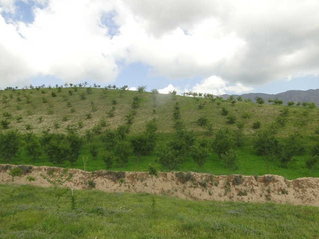
Non-fruit and fruit trees are planted on heavily degraded forest land to protect the land from erosion and further degradation and provide fuelwood for the local community.
2.2 ການອະທິບາຍ ລາຍລະອຽດ ຂອງເຕັກໂນໂລຢີ
ການພັນລະນາ:
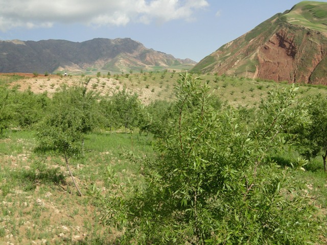
Project supported implementation of afforestation has taken place in the villages of Sari Joy, Jawaz Khana and Dashti Mirzai, located in Chokar watershed of Rustaq District in Northern Afghanistan. The Chokar watershed is a mountainous area situated between 600 and 2,500 m above sea level. The climate is semi-arid with harsh and cold weather in winter, and hot and dry summers. The annual precipitation in average years is 580 mm. Land degradation affects all forms of land use, and includes low levels of vegetation cover, severe water erosion of topsoil, and poor soil fertility. Unsustainable agricultural practices, over-exploitation and high pressure on the natural resources are adversely impacting the socio-economic well-being of local communities, as well as contributing to the risk of being adversely affected by drought - and landslides and flash foods triggered by heavy rainfall. The data used for the documentation of the technology are based on field research conducted in Chokar watershed, namely in the villages of Sari Joy, Jawaz Khana and Dashti Mirzai. These villages represent the upper, the middle and the lower zones of Chokar watershed, respectively. They differ considerably in access to services and infrastructure, but in general are poorly served. The communities depend on land resources for sustaining their livelihoods. In a good year with high yields, wheat self-sufficiency lasts about 5 months. The three villages are home to ethnic Qarluq communities. Since 2012 the Livelihood Improvement Project Takhar (LIPT) implemented by Terre des hommes (Tdh) Switzerland has initiated a range of NRM interventions
Despite the low forest cover in Rustaq, Afghanistan, local communities strongly rely on fuelwood and animal dung for cooking and heating throughout the whole year. Forests are mainly found on community land with open access to all, and there are no protection measures in place. The high demand on fuelwood for household needs places strong pressure on the remaining patches of forests and bushes, which are currently threatened by eradication. Such high demand in the area is likely to remain as there are no other alternative energy sources. The mass destruction of local forests is one of the main causes of intensive erosion, aridification, loss of topsoil and formation of gullies. Low forest cover increases vulnerability to severe rainfall and risks of landslides.
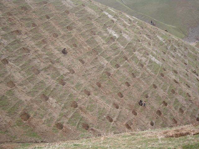
Afforestation measures in the three villages were initiated to halt the land degradation and provide sustainable firewood. The reforestation sites are largely on community land with a small share on private land. The area is characterized by hilly (16-30%) and steep (31-60%) slopes. Planting and maintaining forest in such conditions requires close support in the appropriate design of forest plots, and relevant maintenance recommendations, which can then ensure the survival of the plantation. A plot of 0.2 ha is divided into 4 m x 3 m sections. Each tree is placed in a pit of 50 cm x 30 cm with rich soil around the roots. Once the tree is planted, it is watered and covered with lime. Russian willow, acacia, mulberry and almond are the most common tree species used for afforestation purposes.
Most of the newly established forest sites are located at walking distance of the nearby villages: this is important to help provide protection of the plot from animal intrusion and ensure proper maintenance of the trees. The forest plot is watered for three years in a row. The Natural Resources Management Committees (NRMC) pays 0.60 US cents per tree per year to sustain the survival of the plantation within the first year. The funding for the irrigation is provided by the Livelihood Improvement Project Takhar (LIPT). LIPT supported the afforestation activities through the provision of technical and financial support. The tree seedlings were supplied by the project, and financial incentives were provided to engage the community in tree-planting.
The plantations are still very young: however, the land users express support for the new forest in their villages, and have observed localized stabilization of the soil and improvement in vegetation cover. There are high expectations of the new forest, which promises access to sustainable fuelwood and non-forest products, such as almonds and mulberry. The grass and tree leaves from the forest plots are already used for animal fodder.
Women and children under 15 years old are expected to be the direct beneficiaries of the new forest. They will no longer spend long hours to collect and deliver fuelwood, bushes and dung. A small portion of women reported involvement in forest establishment activities, while the majority are taking part in protecting the forests from livestock.
2.3 ຮູບພາບຂອງເຕັກໂນໂລຢີ
ສື່ຮູບພາບ

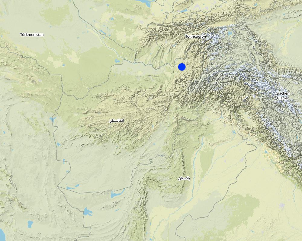
2.5 ປະເທດ / ເຂດ / ສະຖານທີ່ບ່ອນທີ່ ເຕັກໂນໂລຢີ ໄດ້ຮັບການນໍາໃຊ້ ແລະ ທີ່ຖືກປົກຄຸມດ້ວຍການປະເມີນຜົນ
ປະເທດ:
ອັຟການີດສະຖານ
ພາກພື້ນ / ລັດ / ແຂວງ:
Takhar Province, Rustaq District
ຂໍ້ມູນເພີ່ມເຕີມຂອງສະຖານທີ່:
Sari Joy, Jawaz Khana, Dashti Mirzai
ຄວາມຄິດເຫັນ:
This documentation is based on the experiences of SLM impementers from Sari Joy (5 plots), Jawaz Khana, (4 plots), and Dashti Mirzai (3 plots) as compiled during focus group discussions. Additionally insights were gained through interviews in all three villages on farmers experiences and observations of afforestation plots, with both SLM implementers (20) and observers (10).
Map
×2.6 ວັນທີໃນການຈັດຕັ້ງປະຕິບັດ
ຖ້າຫາກວ່າ ບໍ່ຮູ້ຈັກ ປີທີ່ຊັດເຈນ ແມ່ນໃຫ້ປະມານ ວັນທີເອົາ:
- ຕໍ່າກວ່າ 10 ປີ ຜ່ານມາ (ມາເຖິງປະຈຸບັນ)
2.7 ການນໍາສະເໜີ ເຕັກໂນໂລຢີ
ໃຫ້ລະບຸ ເຕັກໂນໂລຢີ ໄດ້ຖືກຈັດຕັ້ງປະຕິບັດຄືແນວໃດ?
- ໂດຍຜ່ານໂຄງການ / ການຊ່ວຍເຫຼືອຈາກພາຍນອກ
ຄວາມຄິດເຫັນ (ປະເພດ ໂຄງການ ແລະ ອື່ນໆ):
Livelihood Improvement Project Takhar (LIPT) supported by Swiss Development Cooperation (SDC) from 2012-17
3. ການໃຈ້ແຍກ ເຕັກໂນໂລຢີ ໃນການຄຸ້ມຄອງ ດິນແບບຍືນຍົງ
3.1 ຈຸດປະສົງຫຼັກ (ຫຼາຍ) ຂອງເຕັກໂນໂລຢີ
- ປັບປຸງ ການຜະລິດ
- ຫຼຸດຜ່ອນ, ປ້ອງກັນ, ຟື້ນຟູ ການເຊື່ອມໂຊມຂອງດິນ
- ຫຼຸດຜ່ອນຄວາມສ່ຽງ ທາງໄພພິບັດທໍາມະຊາດ
3.2 ປະເພດການນໍາໃຊ້ທີ່ດິນ ໃນປະຈຸບັນ() ທີ່ເຕັກໂນໂລຢີ ໄດ້ຖືກນໍາໃຊ້

ປະສົມປະສານ (ການປູກພືດ / ທົ່ງຫຍ້າລ້ຽງສັດ / ຕົ້ນໄມ້), ລວມທັງ ປ່າໄມ້ ແບບປະສົມປະສານ
- ປ່າໄມ້-ທົ່ງຫຍ້າ
ຜະລິດຕະພັນຫຼັກ / ບໍລິການ:
Acacia, Russian willow, mulberry. almond, grass and leaves for fodder
ຖ້າຫາກວ່າ ການນໍາໃຊ້ທີ່ດິນ ມີການປ່ຽນແປງ ໃນເວລາ ຈັດຕັ້ງປະຕິບັດ ເຕັກໂນໂລຢີ, ແມ່ນໃຫ້ລະບຸວ່າ ດິນພື້ນທີ່ດັ່ງກ່າວ ເຄີຍເປັນດິນປະເພດໃດ ກ່ອນການຈັດຕັ້ງປະຕິບັດ ເຕັກໂນໂລຢີ:
Some of the forest land has been heavily degraded and was used as grazing land for an extensive period. Most of the land is forest land.
3.3 ຂໍ້ມູນເພີ່ມເຕີມກ່ຽວກັບການນໍາໃຊ້ທີ່ດິນ
ການສະໜອງນໍ້າ ໃນພື້ນທີ່ ທີ່ໄດ້ນໍາໃຊ້ ເຕັກໂນໂລຢີ:
- ປະສົມປະສານ ກັນລະຫວ່າງ ນໍ້າຝົນ ແລະ ນໍ້າຊົນລະປະທານ
ຄວາມຄິດເຫັນ:
During the first three years the forest requires irrigation due to aridity. The first year of irrigation is supported by the project, and the rest of the irrigation measures are implemented by the local community with the support of the NRMC.
ຈໍານວນ ລະດູການ ປູກໃນປີໜຶ່ງ:
- 1
3.4 ການນໍາໃຊ້ເຕັກໂນໂລຢີ ທີ່ຢູ່ໃນກຸ່ມການຄຸ້ມຄອງ ທີ່ດິນແບບຍືນຍົງ
- ການປັບປຸງດິນ / ພືດຄຸມດິນ
3.5 ການຂະຫຍາຍເຕັກໂນໂລຢີ
ໃຫ້ລະບຸ ການແຜ່ຂະຫຍາຍ ເຕັກໂນໂລຢີ:
- ແຜ່ຂະຫຍາຍຢ່າງໄວວາໃນພື້ນທີ່
ຖ້າຫາກວ່າ ເຕັກໂນໂລຢີ ໄດ້ແຜ່ຂະຫຍາຍທົ່ວພື້ນທີ່ືື ຢ່າງສະໜ່ຳສະເໝີ, ໃຫ້ລະບຸ ເນື້ອທີ່ ໂດຍການຄາດຄະເນ:
- 0.1-1 ກມ 2
ຄວາມຄິດເຫັນ:
23.6 ha
3.6 ມາດຕະການ ການຄຸ້ມຄອງ ທີ່ດິນແບບຍືນຍົງ ປະກອບດ້ວຍ ເຕັກໂນໂລຢີ

ມາດຕະການ ທາງດ້ານພືດພັນ
- V1: ເປັນໄມ້ຢືນຕົ້ນ ແລະ ການປົກຫຸ້ມຂອງໄມ້ພຸ່ມ
- V2: ຫຍ້າ ແລະ ພືດສະໝູນໄພທີ່ເປັນໄມ້ຢືນຕົ້ນ

ມາດຕະການ ທາງດ້ານການຄຸ້ມຄອງ
- M1: ການປ່ຽນແປງ ປະເພດ ການນໍາໃຊ້ທີ່ດິນ
3.7 ປະເພດດິນເຊື່ອມໂຊມ ຫຼັກທີ່ໄດ້ນໍາໃຊ້ ເຕັກໂນໂລຢີ

ດິນເຊາະເຈື່ອນ ໂດຍນໍ້າ
- Wt: ການສູນເສຍຊັ້ນໜ້າດິນ / ການເຊາະເຈື່ອນຜິວໜ້າດິນ

ດິນເຊາະເຈື່ອນ ໂດຍລົມ
- ການສູນເສຍຊັ້ນໜ້າດິນ

ການເຊື່ອມໂຊມ ທາງຊີວະພາບ
- Bc: ການຫຼຸດຜ່ອນການປົກຫຸ້ມຂອງພືດ
- Bq: ປະລິມານ / ອິນຊີວັດຖຸຫຼຸດລົງ

ການເຊື່ອມໂຊມ ຂອງນໍ້າ
- Ha: ສະພາບແຫ້ງແລ້ງ
3.8 ການປ້ອງກັນ, ການຫຼຸດຜ່ອນ, ຫຼືການຟື້ນຟູຂອງການເຊື່ອມໂຊມຂອງດິນ
ໃຫ້ລະບຸ ເປົ້າໝາຍ ເຕັກໂນໂລຢີ ທີ່ພົວພັນ ກັບຄວາມເຊື່ອມໂຊມຂອງດິນ:
- ຫຼຸດຜ່ອນການເຊື່ອມໂຊມຂອງດິນ
- ການຟື້ນຟູ / ຟື້ນຟູດິນທີ່ຊຸດໂຊມ
4. ຂໍ້ກໍາໜົດ, ກິດຈະກໍາການປະຕິບັດ, ວັດຖຸດິບ, ແລະຄ່າໃຊ້ຈ່າຍ
4.1 ເຕັກນິກ ໃນການແຕ້ມແຜນວາດ ເຕັກໂນໂລຢີ
ຜູ້ຂຽນ:
Aslam Qadamov; Roziya Kirgizbekova
ວັນທີ:
03/04/2017
4.2 ການແຕ້ມແຜນວາດອະທິບາຍເຕັກນິກ
The establishment activities begin with selecting the area for reforestation. Most of the reforestation sites are on slopes above 6% steepness . A plot of 0.2 ha is divided into 4 m x 3 m sections. Planting pits of 50 cm x 30 cm are prepared for planting the trees. Each tree is placed in a pit and good soil is added to the roots. Most popular species used for reforestation are: Russian willow, acacia and mulberry. The newly planted tree is watered and the trunk is covered with a lime and water solution for protection and better growth.
4.3 ຂໍ້ມູນທົ່ວໄປກ່ຽວກັບການຄິດໄລ່ປັດໃຈຂາເຂົ້າໃນການຜະລິດ ແລະ ມູນຄ່າອື່ນໆ
ລະບຸ ວິທີການ ຄຳໃຊ້ຈ່າຍ ແລະ ປັດໄຈນໍາເຂົ້າ ທີ່ໄດ້ຄິດໄລ່:
- ຕໍ່ພື້ນທີ່ ທີ່ໄດ້ຈັດຕັ້ງປະຕິບັດ ເຕັກໂນໂລຢີ
ໃຫ້ລະບຸຫົວໜ່ວຍ ຂະໜາດ ແລະ ເນື້ອທີ່:
1 ha
ລະບຸ ສະກຸນເງິນທີ່ໃຊ້ສໍາລັບ ການຄິດໄລ່ຄ່າໃຊ້ຈ່າຍ:
- ໂດລາສະຫະລັດ
ລະບຸ ອັດຕາແລກປ່ຽນ ຈາກໂດລາ ເປັນເງິນຕາທ້ອງຖີ່ນ (ຖ້າກ່ຽວຂ້ອງ): 1 ໂດລາ =:
67.0
ລະບຸ ຄ່າຈ້າງ ຄ່າແຮງງານສະເລ່ຍ ຕໍ່ ວັນ:
5.2-5.3 USD
4.4 ການສ້າງຕັ້ງກິດຈະກໍາ
| ກິດຈະກໍາ | ປະເພດ ມາດຕະການ | ໄລຍະເວລາ | |
|---|---|---|---|
| 1. | Design of the forest plot | ການຈັດການຄຸ້ມຄອງ | Winter |
| 2. | Digging pits 50 cmx 30 cm for tree plantation | ໂຄງສ້າງ | End of winter |
| 3. | Planting tree seedlings 3m x 4m | ການບໍາລຸງລ້ຽງ | Spring/Rainy season |
| 4. | Watering the tree after planting | ການບໍາລຸງລ້ຽງ | Spring |
| 5. | Covering the tree with lime | ມາດຕະການອື່ນໆ | Spring |
4.5 ຕົ້ນທຶນ ແລະ ປັດໄຈຂາເຂົ້າທີ່ຈໍາເປັນໃນຈັດຕັ້ງປະຕິບັດ
| ລະບຸ ປັດໃຈ ນໍາເຂົ້າ ໃນການຜະລີດ | ຫົວໜ່ວຍ | ປະລິມານ | ຕົ້ນທຶນ ຕໍ່ຫົວໜ່ວຍ | ຕົ້ນທຶນທັງໝົດ ຂອງປັດໃຈຂາເຂົ້າ ໃນການຜະລິດ | % ຂອງຕົ້ນທຶນທັງໝົດ ທີ່ຜູ້ນໍາໃຊ້ທີ່ດິນ ໃຊ້ຈ່າຍເອງ | |
|---|---|---|---|---|---|---|
| ແຮງງານ | Design of the forest | person-day | 15.0 | 5.3 | 79.5 | |
| ແຮງງານ | Digging pits/holes for the trees | person-day | 22.0 | 5.3 | 116.6 | |
| ແຮງງານ | Planting tree seedlings and watering | person-day | 15.0 | 5.3 | 79.5 | |
| ແຮງງານ | Fertilizer and lime application | person-day | 8.0 | 5.3 | 42.4 | |
| ອຸປະກອນ | Meter | piece | 1.0 | 2.25 | 2.25 | |
| ອຸປະກອນ | Shovel | piece | 2.0 | 3.8 | 7.6 | |
| ອຸປະກອນ | Pickaxe | piece | 1.0 | 2.25 | 2.25 | |
| ອຸປະກອນ | Rope | meter | 500.0 | 0.07 | 35.0 | |
| ວັດສະດຸໃນການປູກ | Accacia seedlings | piece | 275.0 | 0.45 | 123.75 | |
| ວັດສະດຸໃນການປູກ | Russian willow seedlings | piece | 275.0 | 0.45 | 123.75 | |
| ວັດສະດຸໃນການປູກ | Mulberry seedlings | piece | 275.0 | 0.45 | 123.75 | |
| ຝຸ່ນ ແລະ ຢາຊີວະພາບ | DAP | kg | 250.0 | 0.9 | 225.0 | |
| ຝຸ່ນ ແລະ ຢາຊີວະພາບ | Lime | kg | 25.0 | 1.5 | 37.5 | |
| ຕົ້ນທຶນທັງໝົດ ໃນການຈັດຕັ້ງປະຕິບັດ ເຕັກໂນໂລຢີ | 998.85 | |||||
ຖ້າຫາກຜູ້ນຳໃຊ້ທີ່ດິນ ນຳໃຊ້ມູນຄ່າຕ່ຳກວ່າ 100% ໃຫ້ລະບຸ ແມ່ນໃຜເປັນຜູ້ຊ່ວຍ ໃນລາຍຈ່າຍທີ່ເຫຼືອ:
Livelihood Improvement Project Takhar (LIPT) implemented by Terre des hommes (Tdh) Switzerland
ຄວາມຄິດເຫັນ:
Costs calculated for a Technology area of 1ha was only done for the purpose of the WOCAT documentation. In reality SLM plots are on average 0.4 ha or 2 jiribs. Costs were simply multiplied by 2.5. The actual costs for a 1ha plot might be slightly different.
4.6 ບໍາລຸງຮັກສາ / ແຜນຈັດຕັ້ງປະຕິບັດ ກິດຈະກໍາ
| ກິດຈະກໍາ | ປະເພດ ມາດຕະການ | ໄລຍະເວລາ / ຄວາມຖີ່ | |
|---|---|---|---|
| 1. | Protecting the trees from livestock | ການຈັດການຄຸ້ມຄອງ | Spring/Summer |
| 2. | Pest and disease control | ການບໍາລຸງລ້ຽງ | Spring |
| 3. | Irrigation | ພືດ | Summer/First three years |
| 4. | Replanting dead trees | ການບໍາລຸງລ້ຽງ | Spring |
| 5. | Pruning | ພືດ | Spring |
4.7 ຄ່າໃຊ້ຈ່າຍ ແລະ ປັດໄຈນໍາເຂົ້າທີ່ຈໍາເປັນສໍາລັບການບໍາລຸງຮັກສາກິດຈະກໍາ / ແຜນປະຕິບັດ (ຕໍ່ປີ)
| ລະບຸ ປັດໃຈ ນໍາເຂົ້າ ໃນການຜະລີດ | ຫົວໜ່ວຍ | ປະລິມານ | ຕົ້ນທຶນ ຕໍ່ຫົວໜ່ວຍ | ຕົ້ນທຶນທັງໝົດ ຂອງປັດໃຈຂາເຂົ້າ ໃນການຜະລິດ | % ຂອງຕົ້ນທຶນທັງໝົດ ທີ່ຜູ້ນໍາໃຊ້ທີ່ດິນ ໃຊ້ຈ່າຍເອງ | |
|---|---|---|---|---|---|---|
| ແຮງງານ | Pest and disease control | person day | 7.5 | 5.3 | 39.75 | 100.0 |
| ແຮງງານ | Replanting dead trees | person day | 7.5 | 5.3 | 39.75 | 100.0 |
| ແຮງງານ | Irrigating the trees | person day | 10.0 | 5.3 | 53.0 | 100.0 |
| ແຮງງານ | Pruning | person day | 5.0 | 5.3 | 26.5 | 100.0 |
| ຕົ້ນທຶນທັງໝົດ ທີ່ໃຊ້ໃນການບໍາລຸງຮັກສາ ເຕັກໂນໂລຢີ | 159.0 | |||||
ຄວາມຄິດເຫັນ:
Costs calculated for a Technology area of 1ha was only done for the purpose of the WOCAT documentation. In reality SLM plots are on average 0.4 ha or 2 jiribs. Costs were simply multiplied by 2.5. The actual costs for a 1ha plot might be slightly different.
4.8 ປັດໄຈ ທີ່ສໍາຄັນ ທີ່ສົ່ງຜົນກະທົບ ຕໍ່ຄ່າໃຊ້ຈ່າຍ
ໃຫ້ອະທິບາຍ ປັດໃຈ ທີ່ສົ່ງຜົນກະທົບ ຕໍ່ຕົ້ນທຶນ ໃນການຈັດຕັ້ງປະຕິບັດ:
Due to the remoteness of the villages where the technology has been implemented, all the inputs for establishment, such as agricultural equipment, plant material, fertilizers, etc., are purchased in Rustaq town. The expenses for traveling and delivering the inputs affect the establishment costs.
5. ສະພາບແວດລ້ອມທໍາມະຊາດ ແລະ ມະນຸດ
5.1 ອາກາດ
ປະລິມານນໍ້າຝົນປະຈໍາປີ
- < 250 ມີລິແມັດ
- 251-500 ມີລິແມັດ
- 501-750 ມີລິແມັດ
- 751-1,000 ມີລິແມັດ
- 1,001-1,500 ມີລິແມັດ
- 1,501-2,000 ມີລິແມັດ
- 2,001-3,000 ມີລິແມັດ
- 3,001-4,000 ມີລິແມັດ
- > 4,000 ມີລິແມັດ
ໃຫ້ລະບຸສະເລ່ຍ ປະລິມານນໍ້າຝົນຕົກປະຈໍາປີ ເປັນມິນລິແມັດ (ຖ້າຫາກຮູ້ຈັກ):
564.00
ຂໍ້ມູນສະເພາະ / ຄວາມເຫັນກ່ຽວກັບ ປະລິມານນໍ້າຝົນ:
Average annual precipitation for the area was calculated with 564 mm, with minimum in dry years (2000 and 2001) of 270 mm and maximum in wet years (2009/2010) of 830 mm. The absolute maximum rainfall was calculated for 1986 with 1024 mm. The data series covers the time from 1979 to 2014.
ໃຫ້ລະບຸ ຊື່ສະຖານີ ອຸຕຸນິຍົມ ເພື່ອເປັນຂໍ້ມູນອ້າງອີງ:
Climate Forecast System Reanalysis (CFSR), http://rda.ucar.edu/pub/cfsr.html
ເຂດສະພາບອາກາດກະສິກໍາ
- ເຄິ່ງແຫ້ງແລ້ງ
Derived from the publicly available dataset on length of growing period (LGP) (Fischer 2009 / IIASA-FAO). Internet link: http://tiles.arcgis.com/tiles/P8Cok4qAP1sTVE59/arcgis/rest/services/Length_of_growing_period/MapServer
5.2 ພູມິປະເທດ
ຄ່າສະເລ່ຍ ຄວາມຄ້ອຍຊັນ:
- ພື້ນທີ່ຮາບພຽງ (0-2%)
- ອ່ອນ (3-5 %)
- ປານກາງ (6-10 %)
- ມ້ວນ (11-15 %)
- ເນີນ(16-30%)
- ໍຊັນ (31-60%)
- ຊັນຫຼາຍ (>60%)
ຮູບແບບຂອງດິນ:
- ພູພຽງ / ທົ່ງພຽງ
- ສັນພູ
- ເປີ້ນພູ
- ເນີນພູ
- ຕີນພູ
- ຮ່ອມພູ
ເຂດລະດັບສູງ:
- 0-100 ແມັດ a.s.l.
- 101-500 ແມັດ a.s.l.
- 501-1,000 ແມັດ a.s.l.
- 1,001-1,500 ແມັດ a.s.l.
- 1,501-2,000 ແມັດ a.s.l.
- 2,001-2,500 ແມັດ a.s.l.
- 2,501-3,000 ແມັດ a.s.l.
- 3,001-4,000 ແມັດ a.s.l.
- > 4,000 ແມັດ a.s.l.
5.3 ດິນ
ຄວາມເລິກ ຂອງດິນສະເລ່ຍ:
- ຕື້ນຫຼາຍ (0-20 ຊັງຕີແມັດ)
- ຕື້ນ (21-50 ຊຕມ)
- ເລີກປານກາງ (51-80 ຊຕມ)
- ເລິກ (81-120 ຊມ)
- ເລິກຫຼາຍ (> 120 cm)
ເນື້ອດິນ (ໜ້າດິນ):
- ປານກາງ (ດິນໜຽວ, ດິນໂຄນ)
ເນື້ອດິນ (ເລິກຈາກໜ້າດິນ ລົງໄປຫຼາຍກວ່າ 20 ຊັງຕິແມັດ):
- ປານກາງ (ດິນໜຽວ, ດິນໂຄນ)
ຊັ້ນອິນຊີວັດຖຸ ເທິງໜ້າດິນ:
- ປານກາງ (1-3 %)
- ຕໍາ່ (<1 %)
ຖ້າເປັນໄປໄດ້ ແມ່ນໃຫ້ຕິດຄັດ ການພັນລະນາດິນ ຫຼື ຂໍ້ມູນສະເພາະຂອງດິນ, ຕົວຢ່າງ, ຄຸນລັກສະນະ ປະເພດຂອງດິນ, ຄ່າຄວາມເປັນກົດ / ເປັນດ່າງຂອງດິນ, ສານອາຫານ, ດິນເຄັມ ແລະ ອື່ນໆ.
Local land users refer to the soil type where reforestation is implemented as:
Dark soil is characterized as: moderately deep; topsoil texture medium, below surface texture medium; and medium topsoil organic matter.
Light soil is characterized as: moderately deep; texture medium; medium, low organic matter.
5.4 ມີນໍ້າ ແລະ ຄຸນນະພາບ
ລະດັບ ນໍ້າໃຕ້ດິນ:
5-50 ແມັດ
ການມີນໍ້າ ເທິງໜ້າດິນ:
ປານກາງ
ຄຸນນະພາບນໍ້າ (ບໍ່ມີການບໍາບັດ):
ມີນໍ້າດື່ມ
ມີບັນຫາ ກ່ຽວກັບນໍ້າເຄັມບໍ່?
ບໍ່ແມ່ນ
ເກີດມີນໍ້າຖ້ວມ ໃນພື້ນທີ່ບໍ່?
ແມ່ນ
ເປັນປົກກະຕິ:
ຕອນ
ຄວາມຄິດເຫັນ ແລະ ຂໍ້ກໍານົດ ເພີ່ມເຕີມ ກ່ຽວກັບ ຄຸນນະພາບ ແລະ ປະລິມານ ຂອງນ້ຳ:
Floods occur mainly during the rainy seasons in spring and autumn. Availability of surface water varies in the three study villages. Sari Joy and Dashti Mirzai have good surface water availability, which is also food for drinking. Jawaz Khana has poor water both in quality and availability. Water has to be fetched from a distant stream.
5.5 ຊີວະນາໆພັນ
ຄວາມຫຼາກຫຼາຍ ທາງສາຍພັນ:
- ຕໍ່າ
ຄວາມຫຼາກຫຼາຍ ທາງດ້ານ ທີ່ຢູ່ອາໃສ ຂອງສິ່ງທີ່ມີຊີວິດ:
- ຕໍ່າ
5.6 ຄຸນລັກສະນະ ຂອງຜູ້ນໍາໃຊ້ທີ່ດິນ ທີ່ໄດ້ນໍາໃຊ້ເຕັກໂນໂລຢີ
ຢູ່ປະຈຳ ຫຼື ເຄື່ອນຍ້າຍຕະຫຼອດ:
- ບໍ່ເຄື່ອນໄຫວ
ລະບົບ ການຕະຫຼາດ ແລະ ຜົນຜະລິດ:
- ກຸ້ມຕົນເອງ (ພໍພຽງ)
- ປະສົມ (ກຸ້ມຕົນເອງ / ເປັນສິນຄ້າ
ລາຍຮັບ ທີ່ບໍ່ໄດ້ມາຈາກ ການຜະລິດ ກະສິກໍາ:
- 10-50 % ຂອງລາຍຮັບທັງໝົດ
- > 50 % ຂອງລາຍຮັບທັງໝົດ
ລະດັບຄວາມຮັ່ງມີ:
- ສະເລ່ຍ
- ຮັ່ງມີ
ບຸກຄົນ ຫຼື ກຸ່ມ:
- ບຸກຄົນ / ຄົວເຮືອນ
- ກຸ່ມ / ຊຸມຊົນ
ລະດັບ ການຫັນເປັນກົນຈັກ:
- ການໃຊ້ແຮງງານຄົນ
ເພດ:
- ຜູ້ຍິງ
- ຜູ້ຊາຍ
ອາຍຸ ຂອງຜູ້ນໍາໃຊ້ທີ່ດິນ:
- ໄວກາງຄົນ
- ຜູ້ສູງອາຍຸ
ໃຫ້ລະບຸ ຄຸນລັກສະນະ ຂອງຜູ້ນໍາໃຊ້ທີ່ດິນ:
The land users in the area where the Technology is applied belong to the Uzbek ethnic minority group Qarluq. Although the men are generally the main land users, women and children also take active part in the related work. The functions of men and women are clearly distinguished within the Afghan society. At the same time within the family this division of work and functions also results in men and women working hand-in-hand. An improvement of the family’s livelihood situation is expected to positively affect all family members. While it is recognized that the involvement of women is key in order to secure basic human rights for everyone, to achieve good governance, sustainable development, and to efficiently contribute to poverty reduction (SDC 2004), it is also clear that a context sensitive approach is of high importance.
Women in rural Afghanistan are involved in many production and income generating activities that contribute to the overall household income, however very few women own resources such as land and livestock, and their income generating options are fewer in comparison to that of men.
5.7 ພື້ນທີ່ສະເລ່ຍຂອງທີ່ດິນ ຫຼື ເຊົ່າໂດຍຜູ້ໃຊ້ທີ່ດິນການນໍາໃຊ້ ເຕັກໂນໂລຢີ
- <0.5 ເຮັກຕາ
- 0.5-1 ເຮັກຕາ
- 1-2 ເຮັກຕາ
- 2-5 ເຮັກຕາ
- 5-15 ເຮັກຕາ
- 15-50 ເຮັກຕາ
- 50-100 ເຮັກຕາ
- 100-500 ເຮັກຕາ
- 500-1,000 ເຮັກຕາ
- 1,000-10,000 ເຮັກຕາ
- > 10,000 ເຮັກຕາ
ຖືໄດ້ວ່າ ເປັນຂະໜາດນ້ອຍ, ກາງ ຫຼື ໃຫຍ່ (ອີງຕາມເງື່ອນໄຂ ສະພາບຄວາມເປັນຈິງ ຂອງທ້ອງຖີ່ນ)? :
- ຂະໜາດກາງ
5.8 ເຈົ້າຂອງທີ່ດິນ, ສິດໃຊ້ທີ່ດິນ, ແລະ ສິດທິການນໍາໃຊ້ນໍ້າ
ເຈົ້າຂອງດິນ:
- ຊຸມຊົນ / ບ້ານ
- ບຸກຄົນ, ບໍ່ມີຕໍາແໜ່ງ
ສິດທິ ໃນການນໍາໃຊ້ທີ່ດິນ:
- ຊຸມຊົນ (ທີ່ມີການຈັດຕັ້ງ)
- ບຸກຄົນ
ສິດທິ ໃນການນໍາໃຊ້ນໍ້າ:
- ຊຸມຊົນ (ທີ່ມີການຈັດຕັ້ງ)
ຄວາມຄິດເຫັນ:
Those who own land and use water for irrigation are obliged to pay for water. The payment is made either in kind or in cash to Mirob - the person in charge of distributing water in the community. The amount of the payment varies from village to village.
6. ຜົນກະທົບ ແລະ ລາຍງານສະຫຼຸບ
6.1 ການສະແດງຜົນກະທົບ ພາຍໃນພື້ນທີ່ ທີ່ໄດ້ຈັດຕັ້ງປະຕິບັດ ເຕັກໂນໂລຢີ
ຜົນກະທົບທາງເສດຖະກິດສັງຄົມ
ການຜະລິດ
ການຜະລິດອາຫານສັດ
ຜົນຜະລິດຂອງສັດ
ຜົນຜະລິດໄມ້
ປ່າຜະລິດ
ຄວາມໜາແໜ້ນ ຂອງຜົນຜະລິດ
ຜົນກະທົບດ້ານວັດທະນາທໍາສັງຄົມ
ຄວາມຮູ້ກ່ຽວກັບ ການຄຸ້ມຄອງ ທີ່ດິນແບບຍືນຍົງ / ການເຊື່ອມໂຊມຂອງດິນ
ຄວາມຄິດເຫັນ / ລະບຸແຈ້ງ:
Land users learned new methods of planting trees based on the local conditions.
ສະຖານະການຂອງສັງຄົມ ແລະ ກຸ່ມດ້ອຍໂອກາດທາງເສດຖະກິດ
ຄວາມຄິດເຫັນ / ລະບຸແຈ້ງ:
The established forest is expected to become a reliable source for firewood, which will decrease the burden of women and children under 15 years, who spend long hours to collect firewood.
ຜົນກະທົບຕໍ່ລະບົບນິເວດ
ວົງຈອນນໍ້າ / ນໍ້າ
ການໄຫຼ ຂອງນໍ້າໜ້າດິນ
ດິນ
ການສູນເສຍດິນ
ຊີວະນານາພັນ: ສັດ, ພືດ
ການປົກຫຸ້ມຂອງພືດ
6.2 ຜົນກະທົບທາງອ້ອມ ຈາກການນໍາໃຊ້ເຕັກໂນໂລຢີ
ນໍ້າຖ້ວມຢູ່ເຂດລຸ່ມນໍ້າ
ການທັບຖົມ ຂອງດິນຕະກອນ ຢູ່ເຂດລຸ່ມນໍ້າ
ການປ້ອງກັນ / ຄວາມອາດສາມາດ ການກັ່ນຕອງ
ຄໍາເຫັນກ່ຽວກັບ ການປະເມີນ ຜົນກະທົບ:
Based on the Land User Protocols: Individual SLM implementers were asked to rate the benefits for their Technology. They were asked to indicate production increase of crops; fodder; animals; wood; non-wood forest products; increase in product diversity; or production area. The most important increase they rated with 3, the second most with 2, others with 1 point. Averages of the points given by all SLM implementers are reflected here.
Based on the Land User Protocols: Individual SLM implementers were asked to rate the on-site and off-site impacts of the Technology on water; soil; and vegetation. They were asked to indicate the strength of impacts with three, two or one points. Averages of the points given by all implementers are reflected here.
6.3 ການປ້ອງກັນ ແລະ ຄວາມບອບບາງ ຂອງເຕັກໂນໂລຢິ ໃນການປ່ຽນແປງສະພາບດິນຟ້າອາກາດ ແລະ ກ່ຽວຂ້ອງກັບອາກາດທີ່ມີການປ່ຽນແປງທີ່ຮຸນແຮງ / ໄພພິບັດທາງທໍາມະຊາດ (ຮັບຮູ້ໄດ້ໂດຍຜູ້ນໍາໃຊ້ທີ່ດິນ)
ອາກາດ ທີ່ກ່ຽວພັນກັບຄວາມຮຸນແຮງ (ໄພພິບັດທາງທໍາມະຊາດ)
ໄພພິບັດທາງອຸຕຸນິຍົມ
| ການນໍາໃຊ້ ເຕັກໂນໂລຢີ ສາມາດ ຮັບມື ໄດ້ຄືແນວໃດ? | |
|---|---|
| ພະຍຸຝົນ | ດີຫຼາຍ |
ໄພພິບັດທາງພູມອາກາດ
| ການນໍາໃຊ້ ເຕັກໂນໂລຢີ ສາມາດ ຮັບມື ໄດ້ຄືແນວໃດ? | |
|---|---|
| ແຫ້ງແລ້ງ | ດີ |
ຄວາມຄິດເຫັນ:
Based on the multi-criteria matrix: SLM implementers were asked to jointly discuss and rate how much the SLM technology reduced the lands vulnerability to drought and local rainstorms. Only vulnerability to the most prevalent climate extremes (drought and local rainstorms) was discussed. SLM technologies were rated as reducing vulnerability poorly, well, or very well. The average points reflected here are from multi-criteria matrixes compiled in three villages where the SLM technology had been implemented
6.4 ການວິເຄາະຕົ້ນທຶນ ແລະ ຜົນປະໂຫຍດ
ຈະເຮັດປະໂຫຍດເພື່ອປຽບທຽບກັບຄ່າໃຊ້ຈ່າຍກັບສິ່ງກໍ່ສ້າງ (ຈາກທັດສະນະຂອງຜູ້ນຳໃຊ້ທີ່ດິນ) ໄດ້ແນວໃດ?
ຜົນຕອບແທນ ໃນໄລຍະສັ້ນ:
ຜົນກະທົບທາງບວກຫຼາຍ
ຜົນຕອບແທນ ໃນໄລຍະຍາວ:
ຜົນກະທົບທາງບວກຫຼາຍ
ຄວາມຄິດເຫັນ:
Based on the multi-criteria matrix: During the FGD with SLM implementers, a multi-criteria matrix was elaborated, and different SLM practices were rated. In the framework of this exercise, SLM implementers were asked to jointly discuss and rate short term (1-3 years) and long-term (10 years) returns. As the SLM technology was only implemented 1-2 years ago, it is too early to compare benefits to maintenance costs. Farmers have little experience so far on the actual benefits of the SLM technology. The ratings are mostly based on expected benefits and not on actual benefits.
6.5 ການປັບຕົວຮັບເອົາເຕັກໂນໂລຢີ
- 1-10%
ຖ້າຫາກວ່າມີ, ປະລິມານ (ຈໍານວນຂອງຄົວເຮືອນ / ເນື້ອທີ່ການຄຸ້ມຄອງ):
23.6 ha have been afforested with LIPT support
ທັງໝົດນັ້ນ ແມ່ນໃຜ ທີ່ເປັນຜູ້ປັບຕົວ ໃນການນໍາໃຊ້ ເຕັກໂນໂລຢີ, ມີຈັກຄົນ ທີ່ສາມາດເຮັດເອງໄດ້, ຕົວຢ່າງ, ປາດສະຈາກ ການຊ່ວຍເຫຼືອ ທາງດ້ານອຸປະກອນ / ການຈ່າຍເປັນເງິນ?
- 10-50%
ຄວາມຄິດເຫັນ:
Based on the Land User Protocol: Individual SLM implementers were asked whether they received support for implementing the Technology. Each indicated the type of support he received from the proposed options: "Full Support 100%, Some Support, No Support 0%".
6.6 ການປັບຕົວ
ໄດ້ມີການດັດປັບ ເຕັກໂນໂລຢີ ເພື່ອໃຫ້ແທດເໝາະກັບເງື່ອນໄຂ ການປ່ຽນແປງບໍ?
ບໍ່ແມ່ນ
6.7 ຈຸດແຂງ / ຂໍ້ດີ / ໂອກາດ ໃນການນໍາໃຊ້ ເຕັກໂນໂລຢີ
| ຈຸດແຂງ / ຂໍ້ດີ / ໂອກາດໃນການນໍາໃຊ້ທີ່ດິນ |
|---|
| The tree plantations protect the soil from erosion. The land is less vulnerable to heavy rainfall, which washes off the topsoil |
| There are very high expectations about production of firewood. Availability of firewood in local forest will make it much easier to access firewood for cooking and heating by local households. |
| Apart from firewood and wood production, other non-timber products are provided by the afforestation plots, such as fodder for livestock from grass (alfalfa, sainfoin) and tree leaves during autumn. Also some plots are planted with almond and mulberry, which can be collected for own use or for selling. |
| Local people value the recreational benefit of the forest, which make their villages greener and provide green spaces for the local people. |
| ຈຸດແຂງ / ຈຸດດີ / ໂອກາດ ຈາກທັດສະນະຂອງຜູ້ປ້ອນຂໍ້ມູນ ຫຼື ບຸກຄົນສຳຄັນ |
|---|
| The afforestation measures in the village including establishing the forest and protecting it, mobilizing the community around a common goal, and this has a positive impact on the village as a whole. |
| The planted trees and grass under the trees improve the vegetation cover and increase soil quality, which is then less prone to erosion |
| Improved varieties of fruit and non-fruit tree species used for afforestation help to diversify the tree species in the village and make the soil less resistant to dry spells |
| The expected combined benefits of wood and non-wood products, especially when the harvesting period starts, may have positive impact on households' income and food security. |
6.8 ຈຸດອ່ອນ / ຂໍ້ເສຍ / ຄວາມສ່ຽງ ໃນການນໍາໃຊ້ ເຕັກໂນໂລຢີ ແລະ ວິທີການແກ້ໄຂບັນຫາ
| ຈຸດອ່ອນ / ຂໍ້ເສຍ / ຄວາມສ່ຽງໃນມຸມມອງຂອງຜູ້ນໍາໃຊ້ທີ່ດິນ | ມີວິທີການແກ້ໄຂຄືແນວໃດ? |
|---|---|
| The establishment costs for afforestation measures are very high | |
| The young trees are vulnerability to droughts | |
| During maintenance some plots require irrigation | |
| Afforestation plots, which are established on former grazing land, reduces the grazing land in the village and deprives animals from grazing land |
| ຈຸດອ່ອນ/ຂໍ້ບົກຜ່ອງ/ຄວາມສ່ຽງ ຈາກທັດສະນະຂອງຜູ້ປ້ອນຂໍ້ມູນ ຫຼື ບຸກຄົນສຳຄັນ | ມີວິທີການແກ້ໄຂຄືແນວໃດ? |
|---|---|
| Community provides weak or no protection of the afforestation site, which results in low tree survival | |
| Weak funding sources for irrigation of the afforestation plots, particularly during the first three years when the trees are young, might compromise the new plantations | |
| Afforestation is established mostly on community land, where unclear land tenure rights persist, which may cause conflict in the community over forest vs grazing land |
7. ເອກະສານອ້າງອີງ ແລະ ການເຊື່ອມຕໍ່
7.1 ວິທີການ / ແຫຼ່ງຂໍ້ມູນ
- ການໄປຢ້ຽມຢາມພາກສະໜາມ, ການສໍາຫຼວດພາກສະໜາມ
No field visits were conducted
- ການສໍາພາດ ຜູ້ນໍາໃຊ້ທີ່ດິນ
Focus group discussions (FGD) were organized by the CDE team to collect information from SLM implementers. Total of 15 land users who have implemented afforestation, participated in the FGDs held in the three villages of Sari Joy, Jawaz Khana and Dashti Mirzai.
Interviews were conducted by the HAFL team to collect information from persons representing all the three study villages. Very detailed interviews were conducted with 30 persons interested in afforestation implementation, of which 20 persons are from households that already have implemented afforestation.
- ສໍາພາດ ຊ່ຽວຊານ ການຄຸ້ມຄອງ ດິນແບບຍືນຍົງ
Close collaboration took place during the compilation of this material with the technical staff of the LIPT project in Rustaq.
- ການລວບລວມ ບົດລາຍງານ ແລະ ເອກະສານ ອື່ນໆ ທີ່ມີຢູ່ແລ້ວ
Information provided in the reports of the LIPT project in Rustaq served as an initial source of information during the preparatory phase and also solidifying the description of the technology and area of implementation. Other background papers on Afghanistan were referred to for general information on agriculture and natural resource management in Afghanistan.
7.2 ເອກກະສານອ້າງອີງທີ່ເປັນບົດລາຍງານ
ຫົວຂໍ້, ຜູ້ຂຽນ, ປີ, ISBN:
Guidelines for Focus Groups Discussions
ຫົວຂໍ້, ຜູ້ຂຽນ, ປີ, ISBN:
Methods section of the Rustaq NRM study
ຂໍ້ມູນການເຊື່ອມຕໍ່ ແລະ ເນື້ອໃນ
ຂະຫຍາຍທັງໝົດ ຍຸບທັງໝົດການເຊື່ອມຕໍ່
ບໍ່ມີຂໍ້ມູນການເຊື່ອມຕໍ່
ເນື້ອໃນ
ບໍ່ມີເນື້ອໃນ