Spate Irrigation [ອີຣີແທ]
- ການສ້າງ:
- ປັບປູງ:
- ຜູ້ສັງລວມຂໍ້ມູນ: Unknown User
- ບັນນາທິການ: –
- ຜູ້ທົບທວນຄືນ: Fabian Ottiger, Deborah Niggli, Alexandra Gavilano
technologies_1333 - ອີຣີແທ
ເບິ່ງພາກສ່ວນ
ຂະຫຍາຍທັງໝົດ ຍຸບທັງໝົດ1. ຂໍ້ມູນທົ່ວໄປ
1.2 ຂໍ້ມູນ ການຕິດຕໍ່ພົວພັນ ຂອງບຸກຄົນທີ່ສໍາຄັນ ແລະ ສະຖາບັນ ທີ່ມີສ່ວນຮ່ວມ ໃນການປະເມີນເອກກະສານ ເຕັກໂນໂລຢີ
ບັນດາຜູ້ຕອບແບບສອບຖາມທີ່ສໍາຄັນ ()
ຜຸ້ຊ່ຽວຊານ ດ້ານການຄຸ້ມຄອງ ທີ່ດິນແບບຍືນຍົງ:
Abraham Mehari Haile
UNESCO-IHE Institute for Water Education, Delft, The Netherlands
ເນເທີແລນ
ຊື່ໂຄງການ ທີ່ອໍານວຍຄວາມສະດວກ ໃນການສ້າງເອກກະສານ/ປະເມີນ ເຕັກໂນໂລຢີ (ຖ້າກ່ຽວຂ້ອງ)
Book project: SLM in Practice - Guidelines and Best Practices for Sub-Saharan Africa (SLM in Practice)ຊື່ໂຄງການ ທີ່ອໍານວຍຄວາມສະດວກ ໃນການສ້າງເອກກະສານ/ປະເມີນ ເຕັກໂນໂລຢີ (ຖ້າກ່ຽວຂ້ອງ)
Book project: Water Harvesting – Guidelines to Good Practice (Water Harvesting)ຊື່ສະຖາບັນ (ຫຼາຍສະຖາບັນ) ທີ່ອໍານວຍຄວາມສະດວກ ໃນການສ້າງເອກກະສານ / ປະເມີນ ເຕັກໂນໂລຢີ (ຖ້າກ່ຽວຂ້ອງ)
UNESCO - IHE (UNESCO - IHE) - ເນເທີແລນ1.3 ເງື່ອນໄຂ ກ່ຽວກັບ ການນໍາໃຊ້ຂໍ້ມູນເອກະສານ ທີ່ສ້າງຂື້ນ ໂດຍຜ່ານ ອົງການພາບລວມຂອງໂລກ ທາງດ້ານແນວທາງ ແລະ ເຕັກໂນໂລຢີ ຂອງການອານຸລັກ ທໍາມະຊາດ (WOCAT)
ຜູ້ປ້ອນຂໍ້ມູນ ແລະ ບຸກຄົນສຳຄັນ ທີ່ໃຫ້ຂໍ້ມູນ (ຫຼາຍ) ຍິນຍອມ ຕາມເງື່ອນໄຂ ໃນການນຳໃຊ້ຂໍ້ມູນ ເພື່ອສ້າງເປັນເອກກະສານຂອງ WOCAT:
ແມ່ນ
2. ການອະທິບາຍ ເຕັກໂນໂລຢີ ຂອງການຄຸ້ມຄອງ ທີ່ດິນແບບຍືນຍົງ
2.1 ຄໍາອະທິບາຍສັ້ນຂອງ ເຕັກໂນໂລຢີ
ການກຳໜົດຄວາມໝາຍ ຂອງເຕັກໂນໂລຢີ:
Spate irrigation is a traditional water diversion and spreading technology.
2.2 ການອະທິບາຍ ລາຍລະອຽດ ຂອງເຕັກໂນໂລຢີ
ການພັນລະນາ:
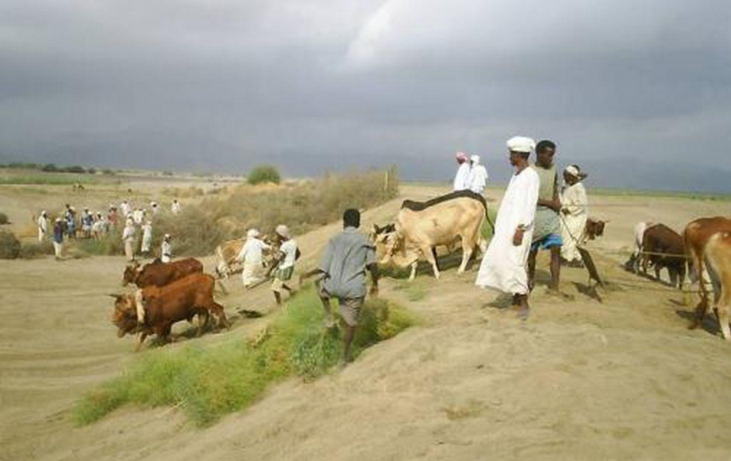
Spate irrigation has a long history in Eritrea and still forms the livelihood base for rural communities in arid lowlands of the country.
Purpose of the Technology: It is a traditional water diversion and spreading technique under which seasonal floods of short duration – springing from the rainfall-rich highlands – are diverted from ephemeral rivers (wadis) to irrigate cascades of leveled and bunded fields in the coastal plains.
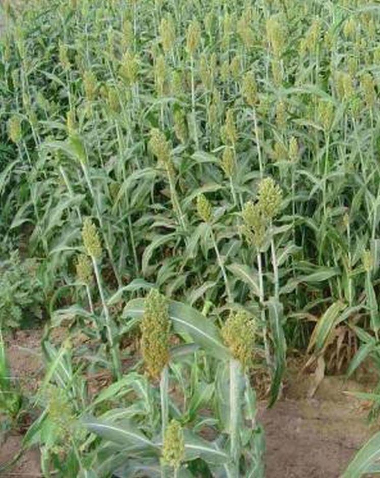
Establishment / maintenance activities and inputs: The diversion structures include the following elements: (1) the ‘agim’, a temporary 3-4 m high river diversion structure on the low-flow side of the wadi, made from brushwood, tree trunks, earth, stones and/or boulders, erected to divert a large part of the flow during a spate flow to adjacent agricultural fields; (2) a primary, and several secondary, distribution canals; unlined, bordered by earthen embankments; convey and spread the floodwater to the irrigable fields; (3) the fields, rectangular shaped, of about 1–2 ha, separated by earthen bunds. Floodwater is distributed from field to field: when a field is completely flooded (to a depth of about 0.5 m), water is conveyed to the immediate downstream field by breaching one of the bunds. This process continues until all the water is used up. Arable fields need to be flooded several times. The water soaks deep into the soil profile (up to 2.4 m) and provides moisture sufficient for two or even three harvests: crop growth is entirely dependent on the residual soil moisture. The main crop grown is sorghum; maize is the next most important. Sedimentation is as important as water management: With each flood, soil is built up by depositing rich sediment on the fields. Due to the force of the floods, the diversion structures are frequently damaged and/or washed away. Reconstruction and maintenance are labour-intensive and require collective community action.
Natural / human environment: Elaborate local regulations, organization and cooperation at the community level are prerequisites for successful management of spate irrigation systems.
2.3 ຮູບພາບຂອງເຕັກໂນໂລຢີ
ສື່ຮູບພາບ
2.5 ປະເທດ / ເຂດ / ສະຖານທີ່ບ່ອນທີ່ ເຕັກໂນໂລຢີ ໄດ້ຮັບການນໍາໃຊ້ ແລະ ທີ່ຖືກປົກຄຸມດ້ວຍການປະເມີນຜົນ
ປະເທດ:
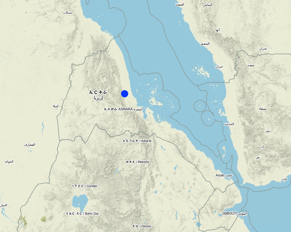
ອີຣີແທ
ພາກພື້ນ / ລັດ / ແຂວງ:
Sheeb area, Eastern lowlands
ຂໍ້ມູນເພີ່ມເຕີມຂອງສະຖານທີ່:
Wadi Laba
ໃຫ້ລະບຸ ການແຜ່ຂະຫຍາຍ ເຕັກໂນໂລຢີ:
- ແຜ່ຂະຫຍາຍຢ່າງໄວວາໃນພື້ນທີ່
ຖ້າຫາກວ່າເຕັກໂນໂລຢີ ໄດ້ກະຈາຍໄປທົ່ວພື້ນທີ່, ໃຫ້ລະບຸເນື້ອທີ່ ທີ່ຖືກປົກຄຸມ (ເປັນ ກິໂລຕາແມັດ):
160.0
ຄວາມຄິດເຫັນ:
Total area covered by the SLM Technology is 160 km2.
Current spate irrigation area in Eritrea is 16’000 hectares. Potential area is estimated at 60’000–90’000 hectares.
Map
×2.6 ວັນທີໃນການຈັດຕັ້ງປະຕິບັດ
ຖ້າຫາກວ່າ ບໍ່ຮູ້ຈັກ ປີທີ່ຊັດເຈນ ແມ່ນໃຫ້ປະມານ ວັນທີເອົາ:
- ຫຼາຍກ່ອນ 50 ປີຜ່ານມາ (ແບບພື້ນບ້ານ)
2.7 ການນໍາສະເໜີ ເຕັກໂນໂລຢີ
ໃຫ້ລະບຸ ເຕັກໂນໂລຢີ ໄດ້ຖືກຈັດຕັ້ງປະຕິບັດຄືແນວໃດ?
- ເປັນສ່ວນໜື່ງຂອງລະບົບພື້ນເມືອງ (>50 ປີ)
ຄວາມຄິດເຫັນ (ປະເພດ ໂຄງການ ແລະ ອື່ນໆ):
Spate irrigation is an indigenous technology, originally introduced from Yemen
3. ການໃຈ້ແຍກ ເຕັກໂນໂລຢີ ໃນການຄຸ້ມຄອງ ດິນແບບຍືນຍົງ
3.1 ຈຸດປະສົງຫຼັກ (ຫຼາຍ) ຂອງເຕັກໂນໂລຢີ
- ປັບປຸງ ການຜະລິດ
- ຫຼຸດຜ່ອນ, ປ້ອງກັນ, ຟື້ນຟູ ການເຊື່ອມໂຊມຂອງດິນ
3.2 ປະເພດການນໍາໃຊ້ທີ່ດິນ ໃນປະຈຸບັນ() ທີ່ເຕັກໂນໂລຢີ ໄດ້ຖືກນໍາໃຊ້

ດິນທີ່ປູກພືດ
- ການປູກພືດປະຈໍາປີ
ການປູກພືດປະຈຳປີ - ລະບຸປະເພດພືດ:
- ທັນຍາພືດ-ສາລີ
- ທັນຍາພືດ-ເຂົ້າຟາງ
ຄວາມຄິດເຫັນ:
Livestock is grazing on crop residues
3.4 ການສະໜອງນ້ຳ
ຄວາມຄິດເຫັນ:
Water supply: post-flooding
3.5 ການນໍາໃຊ້ເຕັກໂນໂລຢີ ທີ່ຢູ່ໃນກຸ່ມການຄຸ້ມຄອງ ທີ່ດິນແບບຍືນຍົງ
- ການຄຸ້ມຄອງຊົນລະປະທານ (ການສະໜອງນໍ້າ, ລະບາຍ)
- ການຄຸ້ມຄອງນໍ້າໜ້າດິນ (ນ້ຳຈາກພຸ, ແມ່ນໍ້າ, ທະເລສາບ, ທະເລ)
3.6 ມາດຕະການ ການຄຸ້ມຄອງ ທີ່ດິນແບບຍືນຍົງ ປະກອບດ້ວຍ ເຕັກໂນໂລຢີ

ມາດຕະການໂຄງສ້າງ
- S3: ຮ່ອງ, ຄອງນໍ້າ, ທາງໄຫຼນໍ້າ
ຄວາມຄິດເຫັນ:
Main measures: structural measures
4. ຂໍ້ກໍາໜົດ, ກິດຈະກໍາການປະຕິບັດ, ວັດຖຸດິບ, ແລະຄ່າໃຊ້ຈ່າຍ
4.1 ເຕັກນິກ ໃນການແຕ້ມແຜນວາດ ເຕັກໂນໂລຢີ
ຄຸນລັກສະນະ ຂອງເຕັກນິກ (ທີ່ກ່ຽວຂ້ອງ ກັບການແຕ້ມແຜນວາດ ທາງດ້ານເຕັກນີກ):
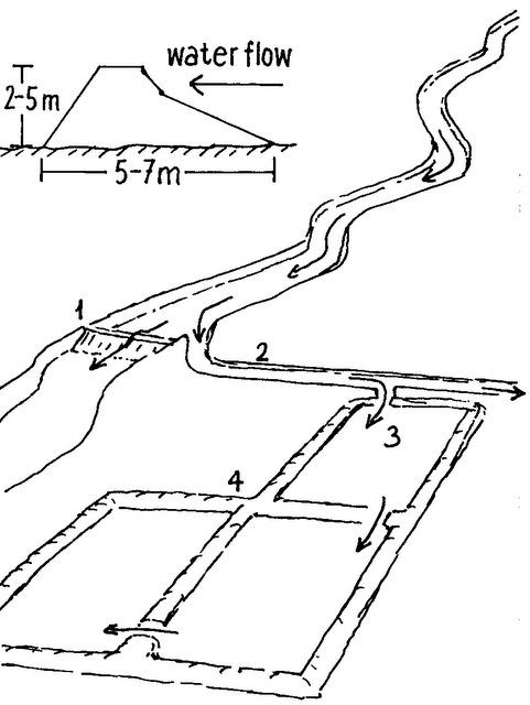
Cross section of an agim (top left); Components of a traditional spate irrigation system: (1) agim; (2) main distribution canal; (3) irrigated fields; (4) earthen embankments. Arrows indicate the water flow
Technical knowledge required for field staff / advisors: high
Technical knowledge required for land users: high
Main technical functions: control of concentrated runoff: drain / divert, increase of infiltration, water harvesting / increase water supply, water spreading
Diversion ditch/ drainage
Depth of ditches/pits/dams (m): 4.00
Construction material (earth): earth
Construction material (stone): stones
Construction material (wood): brushwood, tree trunks
ຜູ້ຂຽນ:
Mats Gurtner, Center for Development and Environment, University of Bern
4.3 ການສ້າງຕັ້ງກິດຈະກໍາ
| ກິດຈະກໍາ | Timing (season) | |
|---|---|---|
| 1. | Construction of diversion structure (agim) | before rainy season |
| 2. | Construction of main distribution canal | before rainy season |
| 3. | Construction of secondary distribution canals | before rainy season |
| 4. | Leveling of fields | before rainy season |
| 5. | Establish embankments around fields and within fields | before rainy season |
4.4 ຕົ້ນທຶນ ແລະ ປັດໄຈຂາເຂົ້າທີ່ຈໍາເປັນໃນຈັດຕັ້ງປະຕິບັດ
| ລະບຸ ປັດໃຈ ນໍາເຂົ້າ ໃນການຜະລີດ | ຫົວໜ່ວຍ | ປະລິມານ | ຕົ້ນທຶນ ຕໍ່ຫົວໜ່ວຍ | ຕົ້ນທຶນທັງໝົດ ຂອງປັດໃຈຂາເຂົ້າ ໃນການຜະລິດ | % ຂອງຕົ້ນທຶນທັງໝົດ ທີ່ຜູ້ນໍາໃຊ້ທີ່ດິນ ໃຊ້ຈ່າຍເອງ | |
|---|---|---|---|---|---|---|
| ແຮງງານ | Labour | ha | 1.0 | 24.0 | 24.0 | |
| ອຸປະກອນ | Animal traction | ha | 1.0 | 36.0 | 36.0 | |
| ຕົ້ນທຶນທັງໝົດ ໃນການຈັດຕັ້ງປະຕິບັດ ເຕັກໂນໂລຢີ | 60.0 | |||||
| ຄ່າໃຊ້ຈ່າຍທັງໝົດ ສຳລັບການສ້າງຕັ້ງເຕັກໂນໂລຢີ ເປັນສະກຸນເງີນໂດລາ | 60.0 | |||||
4.5 ບໍາລຸງຮັກສາ / ແຜນຈັດຕັ້ງປະຕິບັດ ກິດຈະກໍາ
| ກິດຈະກໍາ | ໄລຍະເວລາ / ຄວາມຖີ່ | |
|---|---|---|
| 1. | Reconstruction / repair of diversion structures (2-4 times / year; collective community action) | 2-4 times / year |
| 2. | Desilting / repair of distribution canals | annual |
| 3. | Raising of bund heights due to silting up of fields | annual |
| 4. | Flood fields (community action, during highland rainy season: July-September). Most likely a field receives 3 irrigation turns, on a bi-weekly interval between any 2 turns | rainy season (july-september) |
| 5. | Soil tillage (15 cm deep; using oxen-drawn plough) to break capillary uplift of soil water and to create evaporation barrier | end of flooding season |
4.6 ຄ່າໃຊ້ຈ່າຍ ແລະ ປັດໄຈນໍາເຂົ້າທີ່ຈໍາເປັນສໍາລັບການບໍາລຸງຮັກສາກິດຈະກໍາ / ແຜນປະຕິບັດ (ຕໍ່ປີ)
| ລະບຸ ປັດໃຈ ນໍາເຂົ້າ ໃນການຜະລີດ | ຫົວໜ່ວຍ | ປະລິມານ | ຕົ້ນທຶນ ຕໍ່ຫົວໜ່ວຍ | ຕົ້ນທຶນທັງໝົດ ຂອງປັດໃຈຂາເຂົ້າ ໃນການຜະລິດ | % ຂອງຕົ້ນທຶນທັງໝົດ ທີ່ຜູ້ນໍາໃຊ້ທີ່ດິນ ໃຊ້ຈ່າຍເອງ | |
|---|---|---|---|---|---|---|
| ແຮງງານ | Labour | ha | 1.0 | 24.0 | 24.0 | |
| ອຸປະກອນ | Animal traction | ha | 1.0 | 36.0 | 36.0 | |
| ຕົ້ນທຶນທັງໝົດ ທີ່ໃຊ້ໃນການບໍາລຸງຮັກສາ ເຕັກໂນໂລຢີ | 60.0 | |||||
| ຄ່າໃຊ້ຈ່າຍທັງໝົດ ສຳລັບການບົວລະບັດຮກສາເຕັກໂນໂລຢີ ເປັນສະກຸນເງີນໂດລາ | 60.0 | |||||
ຄວາມຄິດເຫັນ:
Machinery/ tools: scouring and tillage implements, shovels
The costs were calculated per unit = 10 m long agim (1 m high, 3 m wide), constructed with mixed material (stones, earth, brushwood)
4.7 ປັດໄຈ ທີ່ສໍາຄັນ ທີ່ສົ່ງຜົນກະທົບ ຕໍ່ຄ່າໃຊ້ຈ່າຍ
ໃຫ້ອະທິບາຍ ປັດໃຈ ທີ່ສົ່ງຜົນກະທົບ ຕໍ່ຕົ້ນທຶນ ໃນການຈັດຕັ້ງປະຕິບັດ:
Data on labour inputs for construction/maintenance of canals and field bunds are not included, therefore not included in the tables above. Costs for agim reconstruction are 40% of establishment. Total maintenance costs depend on the number of reconstructions during normal spate season (2-4 times). The yearly cost (establishment and maintenance) reaches US$ 60-156.
5. ສະພາບແວດລ້ອມທໍາມະຊາດ ແລະ ມະນຸດ
5.1 ອາກາດ
ປະລິມານນໍ້າຝົນປະຈໍາປີ
- < 250 ມີລິແມັດ
- 251-500 ມີລິແມັດ
- 501-750 ມີລິແມັດ
- 751-1,000 ມີລິແມັດ
- 1,001-1,500 ມີລິແມັດ
- 1,501-2,000 ມີລິແມັດ
- 2,001-3,000 ມີລິແມັດ
- 3,001-4,000 ມີລິແມັດ
- > 4,000 ມີລິແມັດ
ເຂດສະພາບອາກາດກະສິກໍາ
- ແຫ້ງແລ້ງ
Thermal climate class: tropics
5.2 ພູມິປະເທດ
ຄ່າສະເລ່ຍ ຄວາມຄ້ອຍຊັນ:
- ພື້ນທີ່ຮາບພຽງ (0-2%)
- ອ່ອນ (3-5 %)
- ປານກາງ (6-10 %)
- ມ້ວນ (11-15 %)
- ເນີນ(16-30%)
- ໍຊັນ (31-60%)
- ຊັນຫຼາຍ (>60%)
ຮູບແບບຂອງດິນ:
- ພູພຽງ / ທົ່ງພຽງ
- ສັນພູ
- ເປີ້ນພູ
- ເນີນພູ
- ຕີນພູ
- ຮ່ອມພູ
ເຂດລະດັບສູງ:
- 0-100 ແມັດ a.s.l.
- 101-500 ແມັດ a.s.l.
- 501-1,000 ແມັດ a.s.l.
- 1,001-1,500 ແມັດ a.s.l.
- 1,501-2,000 ແມັດ a.s.l.
- 2,001-2,500 ແມັດ a.s.l.
- 2,501-3,000 ແມັດ a.s.l.
- 3,001-4,000 ແມັດ a.s.l.
- > 4,000 ແມັດ a.s.l.
ຄຳເຫັນ ແລະ ຂໍ້ມູນສະເພາະ ເພີ່ມເຕີມ ກ່ຽວກັບ ພູມີປະເທດ:
Altitudinal zone: 101-500 m a.s.l. (200 m.a.s.l.)
5.3 ດິນ
ຄວາມເລິກ ຂອງດິນສະເລ່ຍ:
- ຕື້ນຫຼາຍ (0-20 ຊັງຕີແມັດ)
- ຕື້ນ (21-50 ຊຕມ)
- ເລີກປານກາງ (51-80 ຊຕມ)
- ເລິກ (81-120 ຊມ)
- ເລິກຫຼາຍ (> 120 cm)
ເນື້ອດິນ (ໜ້າດິນ):
- ປານກາງ (ດິນໜຽວ, ດິນໂຄນ)
ຖ້າເປັນໄປໄດ້ ແມ່ນໃຫ້ຕິດຄັດ ການພັນລະນາດິນ ຫຼື ຂໍ້ມູນສະເພາະຂອງດິນ, ຕົວຢ່າງ, ຄຸນລັກສະນະ ປະເພດຂອງດິນ, ຄ່າຄວາມເປັນກົດ / ເປັນດ່າງຂອງດິນ, ສານອາຫານ, ດິນເຄັມ ແລະ ອື່ນໆ.
Soil texture is medium (loam to silt loams)
Soil fertility is very high (alluvial silts formed by annual sedimentation)
Soil drainage/infiltration is good
5.4 ມີນໍ້າ ແລະ ຄຸນນະພາບ
ການມີນໍ້າ ເທິງໜ້າດິນ:
ເກີນ
5.6 ຄຸນລັກສະນະ ຂອງຜູ້ນໍາໃຊ້ທີ່ດິນ ທີ່ໄດ້ນໍາໃຊ້ເຕັກໂນໂລຢີ
ລະບົບ ການຕະຫຼາດ ແລະ ຜົນຜະລິດ:
- ກຸ້ມຕົນເອງ (ພໍພຽງ)
ລະດັບຄວາມຮັ່ງມີ:
- ທຸກຍາກຫຼາຍ
- ທຸກຍາກ
ບຸກຄົນ ຫຼື ກຸ່ມ:
- ກຸ່ມ / ຊຸມຊົນ
ລະດັບ ການຫັນເປັນກົນຈັກ:
- ການໃຊ້ແຮງງານຄົນ
- ສັດລາກແກ່
ໃຫ້ລະບຸ ຄຸນລັກສະນະ ຂອງຜູ້ນໍາໃຊ້ທີ່ດິນ:
Land users applying the Technology are mainly disadvantaged land users
Difference in the involvement of women and men: water management carried out communally, crop management individually
5.7 ເນື້ອທີ່ສະເລ່ຍຂອງດິນ ທີ່ຜູ້ນຳໃຊ້ທີ່ດິນ ໃຊ້ເຮັດເຕັກໂນໂລຢີ
- <0.5 ເຮັກຕາ
- 0.5-1 ເຮັກຕາ
- 1-2 ເຮັກຕາ
- 2-5 ເຮັກຕາ
- 5-15 ເຮັກຕາ
- 15-50 ເຮັກຕາ
- 50-100 ເຮັກຕາ
- 100-500 ເຮັກຕາ
- 500-1,000 ເຮັກຕາ
- 1,000-10,000 ເຮັກຕາ
- > 10,000 ເຮັກຕາ
ຖືໄດ້ວ່າ ເປັນຂະໜາດນ້ອຍ, ກາງ ຫຼື ໃຫຍ່ (ອີງຕາມເງື່ອນໄຂ ສະພາບຄວາມເປັນຈິງ ຂອງທ້ອງຖີ່ນ)? :
- ຂະໜາດນ້ອຍ
5.8 ເຈົ້າຂອງທີ່ດິນ, ສິດໃຊ້ທີ່ດິນ, ແລະ ສິດທິການນໍາໃຊ້ນໍ້າ
ເຈົ້າຂອງດິນ:
- ລັດ
ສິດທິ ໃນການນໍາໃຊ້ທີ່ດິນ:
- ບຸກຄົນ
6. ຜົນກະທົບ ແລະ ລາຍງານສະຫຼຸບ
6.1 ການສະແດງຜົນກະທົບ ພາຍໃນພື້ນທີ່ ທີ່ໄດ້ຈັດຕັ້ງປະຕິບັດ ເຕັກໂນໂລຢີ
ຜົນກະທົບທາງເສດຖະກິດສັງຄົມ
ການຜະລິດ
ການຜະລິດພືດ
ການຜະລິດອາຫານສັດ
ຄວາມຄິດເຫັນ / ລະບຸແຈ້ງ:
Residues are fed to livestock
ເນື້ອທີ່ການຜະລິດ
ຄວາມຄິດເຫັນ / ລະບຸແຈ້ງ:
Without irrigation, agricultural production is not possible
ລາຍໄດ້ ແລະ ຄ່າໃຊ້ຈ່າຍ
ລາຍຮັບ ຈາກການຜະລີດ
ຜົນກະທົບດ້ານວັດທະນາທໍາສັງຄົມ
ການຄໍ້າປະກັນ ສະບຽງອາຫານ / ກຸ້ມຢູ່ກຸ້ມກິນ
ສະຖາບັນ ການຈັດຕັ້ງຊຸມຊົນ
ຜົນກະທົບຕໍ່ລະບົບນິເວດ
ວົງຈອນນໍ້າ / ນໍ້າ
ການຂຸດຄົ້ນ / ການເກັບກັກນໍ້າ
ດິນ
ຄວາມຊຸ່ມຂອງດິນ
ວົງຈອນ ຂອງສານອາຫານໃນດິນ
6.3 ການປ້ອງກັນ ແລະ ຄວາມບອບບາງ ຂອງເຕັກໂນໂລຢິ ໃນການປ່ຽນແປງສະພາບດິນຟ້າອາກາດ ແລະ ກ່ຽວຂ້ອງກັບອາກາດທີ່ມີການປ່ຽນແປງທີ່ຮຸນແຮງ / ໄພພິບັດທາງທໍາມະຊາດ (ຮັບຮູ້ໄດ້ໂດຍຜູ້ນໍາໃຊ້ທີ່ດິນ)
ການປ່ຽນແປງດິນຟ້າອາກາດ ເທື່ອລະກ້າວ
ການປ່ຽນແປງດິນຟ້າອາກາດ ເທື່ອລະກ້າວ
| ລະດູການ | ເພີ່ມຂື້ນ ຫຼື ຫຼຸດລົງ | ການນໍາໃຊ້ ເຕັກໂນໂລຢີ ສາມາດ ຮັບມື ໄດ້ຄືແນວໃດ? | |
|---|---|---|---|
| ອຸນຫະພູມປະຈໍາປີ | ເພີ່ມຂື້ນ | ດີ |
ອາກາດ ທີ່ກ່ຽວພັນກັບຄວາມຮຸນແຮງ (ໄພພິບັດທາງທໍາມະຊາດ)
ໄພພິບັດທາງອຸຕຸນິຍົມ
| ການນໍາໃຊ້ ເຕັກໂນໂລຢີ ສາມາດ ຮັບມື ໄດ້ຄືແນວໃດ? | |
|---|---|
| ພະຍຸຝົນ | ດີ |
| ພາຍຸລົມທ້ອງຖິ່ນ | ດີ |
ໄພພິບັດທາງພູມອາກາດ
| ການນໍາໃຊ້ ເຕັກໂນໂລຢີ ສາມາດ ຮັບມື ໄດ້ຄືແນວໃດ? | |
|---|---|
| ແຫ້ງແລ້ງ | ດີ |
ໄພພິບັດທາງອຸທົກກະສາກ
| ການນໍາໃຊ້ ເຕັກໂນໂລຢີ ສາມາດ ຮັບມື ໄດ້ຄືແນວໃດ? | |
|---|---|
| ໂດຍທົ່ວໄປ (ແມ່ນໍ້າ) ນໍ້າຖ້ວມ | ດີ |
ຄວາມຄິດເຫັນ:
The technology is tolerant to climatic extremes (adapted to unpredictable heavy floods)
6.4 ການວິເຄາະຕົ້ນທຶນ ແລະ ຜົນປະໂຫຍດ
ຄວາມຄິດເຫັນ:
no data
6.5 ການປັບຕົວຮັບເອົາເຕັກໂນໂລຢີ
ຄວາມຄິດເຫັນ:
There is a strong trend towards spontaneous adoption of the Technology
Comments on adoption trend: Spontaneous spread takes place throughout the lowlands. Current spate irrigation area in Eritrea is 16’000 hectares. Potential area is estimated at 60’000–90’000 hectares.
6.7 ຈຸດແຂງ / ຂໍ້ດີ / ໂອກາດ ໃນການນໍາໃຊ້ ເຕັກໂນໂລຢີ
| ຈຸດແຂງ / ຈຸດດີ / ໂອກາດ ຈາກທັດສະນະຂອງຜູ້ປ້ອນຂໍ້ມູນ ຫຼື ບຸກຄົນສຳຄັນ |
|---|
| Spate irrigation forms the livelihood base for rural communities in arid lowlands of the country |
6.8 ຈຸດອ່ອນ / ຂໍ້ເສຍ / ຄວາມສ່ຽງ ໃນການນໍາໃຊ້ ເຕັກໂນໂລຢີ ແລະ ວິທີການແກ້ໄຂບັນຫາ
| ຈຸດອ່ອນ / ຂໍ້ເສຍ / ຄວາມສ່ຽງໃນມຸມມອງຂອງຜູ້ນໍາໃຊ້ທີ່ດິນ | ມີວິທີການແກ້ໄຂຄືແນວໃດ? |
|---|---|
| Highly labour-intensive and time consuming maintenance; water diversion structures are frequently breached / washed away by heavy floods; canals are obstructed through deposition of boulders, gravel and coarse sediments. | To overcome all 3 problems, recommendations focus on building permanent flood diversion and distribution structures which: |
| Great demand for wood: huge numbers of trees are annually needed for (re-)constructing diversion structures | (1) withstand the force of heavy floods and divert the water effectively; |
| Irrigation efficiency is only about 20% because of the difficulty of controlling large amounts of water in a short period of time (and often at night) and because water is lost by percolation, seepage and evaporation | (2) eliminate the need to cut trees |
| (3) reduce human and animal labour inputs | |
| (4) increase productivity; Lining the main canals with cements would reduce water loss by percolation and seepage. Proper leveling of basin fields helps to distribute the floodwater uniformly |
7. ເອກະສານອ້າງອີງ ແລະ ການເຊື່ອມຕໍ່
7.2 ເອກກະສານອ້າງອີງທີ່ເປັນບົດລາຍງານ
ຫົວຂໍ້, ຜູ້ຂຽນ, ປີ, ISBN:
Abraham Mehari H, Van Steenbergen F, Verheijen O, Van Aarst S:Spate Irrigation, Livelihood Improvement and Adaptation to Climate Variability and Change
ຫົວຂໍ້, ຜູ້ຂຽນ, ປີ, ISBN:
Mehretab Tesfai Stroosnijder L:The Eritrean spate irrigation system
ຫົວຂໍ້, ຜູ້ຂຽນ, ປີ, ISBN:
Berhane Haile G, Van Steenbergen F: Agricultural Water Management in Ephemeral Rivers: Community Management in Spate Irrigation in Eritrea; in African Water Journal
7.3 ເຊື່ອມຕໍ່ກັບຂໍ້ມູນທີ່ກ່ຽວຂ້ອງໂດຍກົງ
ຫົວຂໍ້ / ພັນລະນາ:
Abraham Mehari, Depeweg, H, Schultz B (2005): Hydraulic Performance Evaluation of The Wadi Laba Spate Irrigation Systemin Eritrea, in Irrigation and Drainage. 54: 389–406
URL:
www.interscience.wiley.com
ຫົວຂໍ້ / ພັນລະນາ:
Berhane Haile G: Community Spate Irrigation in Bada, Eritrea n Mehretab Tesfai, Stroosnijder L (2000): The Eritrean spate irrigation system
URL:
linkinghub.elsevier.com/retrieve/pii/S0378377400001153
ຂໍ້ມູນການເຊື່ອມຕໍ່ ແລະ ເນື້ອໃນ
ຂະຫຍາຍທັງໝົດ ຍຸບທັງໝົດການເຊື່ອມຕໍ່
ບໍ່ມີຂໍ້ມູນການເຊື່ອມຕໍ່
ເນື້ອໃນ
ບໍ່ມີເນື້ອໃນ