Contour Trench cum Bund [ອິນເດຍ]
- ການສ້າງ:
- ປັບປູງ:
- ຜູ້ສັງລວມຂໍ້ມູນ: Niranjan Sahu
- ບັນນາທິການ: –
- ຜູ້ທົບທວນຄືນ: Fabian Ottiger, Alexandra Gavilano
Samapatana nali o huda ( Oriya)
technologies_1480 - ອິນເດຍ
ເບິ່ງພາກສ່ວນ
ຂະຫຍາຍທັງໝົດ ຍຸບທັງໝົດ1. ຂໍ້ມູນທົ່ວໄປ
1.2 ຂໍ້ມູນ ການຕິດຕໍ່ພົວພັນ ຂອງບຸກຄົນທີ່ສໍາຄັນ ແລະ ສະຖາບັນ ທີ່ມີສ່ວນຮ່ວມ ໃນການປະເມີນເອກກະສານ ເຕັກໂນໂລຢີ
ຜຸ້ຊ່ຽວຊານ ດ້ານການຄຸ້ມຄອງ ທີ່ດິນແບບຍືນຍົງ:
ຜຸ້ຊ່ຽວຊານ ດ້ານການຄຸ້ມຄອງ ທີ່ດິນແບບຍືນຍົງ:
Patel Anita
1.3 ເງື່ອນໄຂ ກ່ຽວກັບ ການນໍາໃຊ້ຂໍ້ມູນເອກະສານ ທີ່ສ້າງຂື້ນ ໂດຍຜ່ານ ອົງການພາບລວມຂອງໂລກ ທາງດ້ານແນວທາງ ແລະ ເຕັກໂນໂລຢີ ຂອງການອານຸລັກ ທໍາມະຊາດ (WOCAT)
ຜູ້ປ້ອນຂໍ້ມູນ ແລະ ບຸກຄົນສຳຄັນ ທີ່ໃຫ້ຂໍ້ມູນ (ຫຼາຍ) ຍິນຍອມ ຕາມເງື່ອນໄຂ ໃນການນຳໃຊ້ຂໍ້ມູນ ເພື່ອສ້າງເປັນເອກກະສານຂອງ WOCAT:
ແມ່ນ
1.5 ແບບສອບຖາມທີ່ອ້າງອີງເຖີງແນວທາງ ການຄຸ້ມຄອງທີ່ດິນແບບຍືນຍົງ (ໄດ້ເຮັດເປັນເອກະສານທີ່ໃຊ້ WOCAT)

Participatory Sustainable Rural Livelihood Approach [ອິນເດຍ]
Participatory Sustainable Rural Livelihood Approach adopts participatory tools for livelihood situational analysis of the five capitals(Physical, Financila,Social, Human and Natural) and prepare livelihood focussed micro plan with the commuity for sustai
- ຜູ້ສັງລວມຂໍ້ມູນ: Niranjan Sahu
2. ການອະທິບາຍ ເຕັກໂນໂລຢີ ຂອງການຄຸ້ມຄອງ ທີ່ດິນແບບຍືນຍົງ
2.1 ຄໍາອະທິບາຍສັ້ນຂອງ ເຕັກໂນໂລຢີ
ການກຳໜົດຄວາມໝາຍ ຂອງເຕັກໂນໂລຢີ:
Contour trench cum bund is a bund laid out on contour along with trench either staggered or continuous to check the velocity of run off, conserve in situ moisture, increse ground water recharge and there by establish a sustainable land use system.
2.2 ການອະທິບາຍ ລາຍລະອຽດ ຂອງເຕັກໂນໂລຢີ
ການພັນລະນາ:
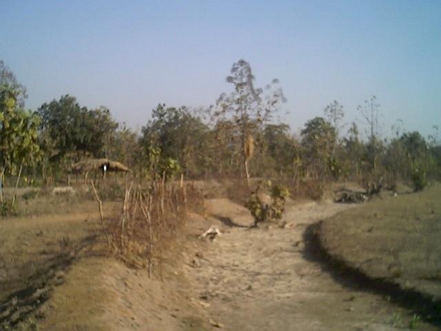
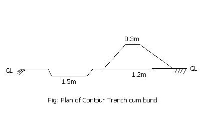
It is a structural measure. The bund is constructed taking the excavated earth from a trench of 1.5m X 0.3m cross section and leaving a berm of 0.3m and put along the contour. Loose boulder water way are constructed on the bund for safe disposal of excess run off.
Purpose: To break the slope of land. To reduce the velocity of runoff. To increase the in situ soil moisture and increase ground water table. To reduce down stream sand casting.
Establishment / maintenance activities and inputs: The process adopted for implementation of the intervention followed participatory planning through resource mapping, transect, well being ranking, problem identification, prioritisation and negotiation; thus benefit sharing, contribution and future maintenance of the stucture is ensured before establishment of the structure. The poor land and poor people get the opportunity first.
2.3 ຮູບພາບຂອງເຕັກໂນໂລຢີ
ສື່ຮູບພາບ
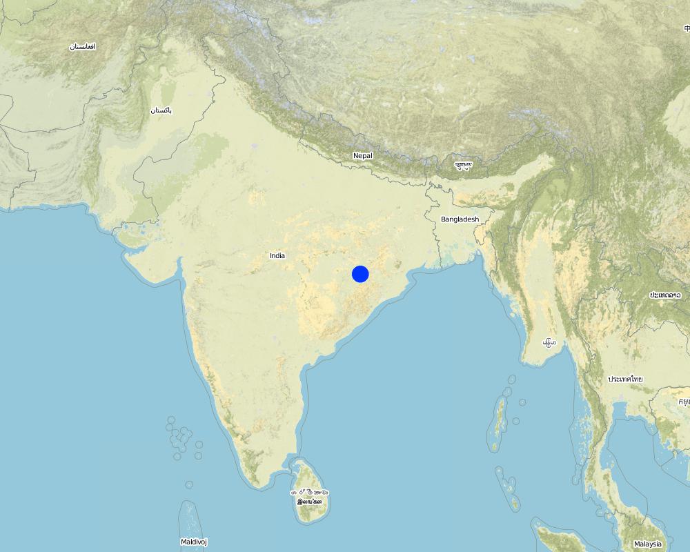
2.5 ປະເທດ / ເຂດ / ສະຖານທີ່ບ່ອນທີ່ ເຕັກໂນໂລຢີ ໄດ້ຮັບການນໍາໃຊ້ ແລະ ທີ່ຖືກປົກຄຸມດ້ວຍການປະເມີນຜົນ
ປະເທດ:
ອິນເດຍ
ພາກພື້ນ / ລັດ / ແຂວງ:
Orissa
ຂໍ້ມູນເພີ່ມເຕີມຂອງສະຖານທີ່:
Nangalbod-Tankamal Watershed,Mahanadi Basin
ໃຫ້ລະບຸ ການແຜ່ຂະຫຍາຍ ເຕັກໂນໂລຢີ:
- ແຜ່ຂະຫຍາຍຢ່າງໄວວາໃນພື້ນທີ່
ຖ້າຫາກວ່າເຕັກໂນໂລຢີ ໄດ້ກະຈາຍໄປທົ່ວພື້ນທີ່, ໃຫ້ລະບຸເນື້ອທີ່ ທີ່ຖືກປົກຄຸມ (ເປັນ ກິໂລຕາແມັດ):
0.32
ຖ້າຫາກບໍ່ຮູ້ເນື້ອທີ່ທີ່ແນ່ນອນ, ໃຫ້ລະບຸ ເນື້ອທີ່ໂດຍປະມານ ທີ່ໃກ້ຄຽງ:
- 0.1-1 ກມ 2
ຄວາມຄິດເຫັນ:
Total area covered by the SLM Technology is 0.32 km2.
The technology area comprises of 0.3 2km2 within the watershed of 6 km2. The technology is an improvement of the age old practice of field bunding by the farmers.This has been promoted by the Soil Conservation department and watershed mission through watershed development programme.
Map
×2.6 ວັນທີໃນການຈັດຕັ້ງປະຕິບັດ
ຖ້າຫາກວ່າ ບໍ່ຮູ້ຈັກ ປີທີ່ຊັດເຈນ ແມ່ນໃຫ້ປະມານ ວັນທີເອົາ:
- ຫຼາຍກ່ອນ 50 ປີຜ່ານມາ (ແບບພື້ນບ້ານ)
2.7 ການນໍາສະເໜີ ເຕັກໂນໂລຢີ
ໃຫ້ລະບຸ ເຕັກໂນໂລຢີ ໄດ້ຖືກຈັດຕັ້ງປະຕິບັດຄືແນວໃດ?
- ໂດຍຜ່ານໂຄງການ / ການຊ່ວຍເຫຼືອຈາກພາຍນອກ
ຄວາມຄິດເຫັນ (ປະເພດ ໂຄງການ ແລະ ອື່ນໆ):
Indegeneous but improved by Soil Conservation department, Watershed Mission, UNDP.
3. ການໃຈ້ແຍກ ເຕັກໂນໂລຢີ ໃນການຄຸ້ມຄອງ ດິນແບບຍືນຍົງ
3.1 ຈຸດປະສົງຫຼັກ (ຫຼາຍ) ຂອງເຕັກໂນໂລຢີ
- ຫຼຸດຜ່ອນ, ປ້ອງກັນ, ຟື້ນຟູ ການເຊື່ອມໂຊມຂອງດິນ
3.2 ປະເພດການນໍາໃຊ້ທີ່ດິນ ໃນປະຈຸບັນ() ທີ່ເຕັກໂນໂລຢີ ໄດ້ຖືກນໍາໃຊ້
ການນຳໃຊ້ທີ່ດິນ ປະສົມພາຍໃນພື້ນທີ່ດຽວກັນ:
ແມ່ນ
ລະບຸການນຳໃຊ້ທີ່ດິນແບບປະສົມ (ຜົນລະປູກ / ທົ່ງຫຍ້າລ້ຽງສັດ / ຕົ້ນໄມ້):
- ປ່າໄມ້-ທົ່ງຫຍ້າ

ດິນທີ່ປູກພືດ
- ການປູກພືດປະຈໍາປີ
ການປູກພືດປະຈຳປີ - ລະບຸປະເພດພືດ:
- ທັນຍາພືດ-ເຂົ້າຟາງ
- rice
ຈໍານວນ ລະດູການ ປູກໃນປີໜຶ່ງ:
- 1
ລະບຸ ຊະນິດ:
Longest growing period in days: 150 Longest growing period from month to month: Jun - Oct

ທົ່ງຫຍ້າລ້ຽງສັດ
ການລ້ຽງສັດແບບປ່ອຍ ຕາມທຳມະຊາດ:
- ແບບປ່ອຍ ຕາມທຳມະຊາດ
- cattle

ປ່າໄມ້ / ປ່າ
- (ເຄິ່ງ) ປ່າໄມ້ທໍາມະຊາດ / ປ່າປູກໄມ້
(ເຄີ່ງ) ປ່າທໍາມະຊາດ / ປ່າປູກ: ລະບຸປະເພດການຄຸ້ມຄອງ:
- ການຄັດເລືອກຕັດ
ຜົນຜະລິດ ແລະ ການບໍລິການ:
- ໄມ້ຟືນ
- ໝາກໄມ້ ແລະ ແກ່ນຖົ່ວ
- ທົ່ງຫຍ້າ
ຄວາມຄິດເຫັນ:
Major land use problems (compiler’s opinion): The fertile top soil is gradually washed away.Productivity of the soil is also reduced. Thus, farmer is only taking minor millet in kharif.
Major land use problems (land users’ perception): Loss of production. Soil is unable to retain moisture, so we suffer crop loss during long dry spell.Due to sand casting crop is also partially damaged in the down stream.
Nomadism: People allow the cattle to graze freely in the field after the crop is harvested
Selective felling of (semi-) natural forests: Yes
Problems / comments regarding forest use: People have started managing forest through VSS and Forest protection committee.
Type of cropping system and major crops comments: minor millets and up land paddy are the major crop under rain fed condition
3.4 ການສະໜອງນ້ຳ
ການສະໜອງນໍ້າ ໃນພື້ນທີ່ ທີ່ໄດ້ນໍາໃຊ້ ເຕັກໂນໂລຢີ:
- ນໍ້າຝົນ
3.5 ການນໍາໃຊ້ເຕັກໂນໂລຢີ ທີ່ຢູ່ໃນກຸ່ມການຄຸ້ມຄອງ ທີ່ດິນແບບຍືນຍົງ
- ມາດຕະການ ຕັດຂວາງ ກັບຄວາມຄ້ອຍຊັນ
- ຄວາມຫຼາກຫຼາຍຂອງນໍ້າ ແລະ ການລະບາຍ
- ການຄຸ້ມຄອງນໍ້າໜ້າດິນ (ນ້ຳຈາກພຸ, ແມ່ນໍ້າ, ທະເລສາບ, ທະເລ)
3.6 ມາດຕະການ ການຄຸ້ມຄອງ ທີ່ດິນແບບຍືນຍົງ ປະກອບດ້ວຍ ເຕັກໂນໂລຢີ
3.7 ປະເພດດິນເຊື່ອມໂຊມ ຫຼັກທີ່ໄດ້ນໍາໃຊ້ ເຕັກໂນໂລຢີ

ດິນເຊາະເຈື່ອນ ໂດຍນໍ້າ
- Wt: ການສູນເສຍຊັ້ນໜ້າດິນ / ການເຊາະເຈື່ອນຜິວໜ້າດິນ
- Wg: ການເຊາະເຈື່ອນຮ່ອງນ້ຳ / ຫ້ວຍ
ຄວາມຄິດເຫັນ:
Main type of degradation addressed: Wt: loss of topsoil / surface erosion
Secondary types of degradation addressed: Wg: gully erosion / gullying
Main causes of degradation: deforestation / removal of natural vegetation (incl. forest fires), education, access to knowledge and support services (Absence of institutional arrangements to disseminate the knowledge from lab to land and involve the users in implementation)
Secondary causes of degradation: overgrazing (Subsistence economy, dependance on forests for fuelwood and fodder, livestock were low quality, free grazing type. And these were no regulatory mechanisms to share usufruct from forests with people.), poverty / wealth (Lack of capital at the grassroot to take the initiative by the farmers themselves)
3.8 ການປ້ອງກັນ, ການຫຼຸດຜ່ອນ, ຫຼືການຟື້ນຟູຂອງການເຊື່ອມໂຊມຂອງດິນ
ໃຫ້ລະບຸ ເປົ້າໝາຍ ເຕັກໂນໂລຢີ ທີ່ພົວພັນ ກັບຄວາມເຊື່ອມໂຊມຂອງດິນ:
- ຫຼຸດຜ່ອນການເຊື່ອມໂຊມຂອງດິນ
4. ຂໍ້ກໍາໜົດ, ກິດຈະກໍາການປະຕິບັດ, ວັດຖຸດິບ, ແລະຄ່າໃຊ້ຈ່າຍ
4.1 ເຕັກນິກ ໃນການແຕ້ມແຜນວາດ ເຕັກໂນໂລຢີ
ຄຸນລັກສະນະ ຂອງເຕັກນິກ (ທີ່ກ່ຽວຂ້ອງ ກັບການແຕ້ມແຜນວາດ ທາງດ້ານເຕັກນີກ):
Technical knowledge required for field staff / advisors: moderate
Technical knowledge required for land users: low
Main technical functions: reduction of slope length
Secondary technical functions: control of dispersed runoff: retain / trap, control of concentrated runoff: impede / retard
Bund/ bank: semi-circular/V shaped trapezoidal
Vertical interval between structures (m): 1.5
Spacing between structures (m): 50
Height of bunds/banks/others (m): 0.45
Width of bunds/banks/others (m): 1.2
Length of bunds/banks/others (m): 60
Construction material (earth): earth is dug from the trench in the up stream
Construction material (stone): picked up boulders available locally
Slope (which determines the spacing indicated above): 3%
4.2 ຂໍ້ມູນທົ່ວໄປກ່ຽວກັບການຄິດໄລ່ປັດໃຈຂາເຂົ້າໃນການຜະລິດ ແລະ ມູນຄ່າອື່ນໆ
ສະກຸນເງິນອື່ນໆ / ປະເທດອື່ນໆ (ລະບຸ):
Indian Rupee
ຖ້າກ່ຽວຂ້ອງ, ໃຫ້ລະບຸອັດຕາແລກປ່ຽນຈາກ USD ເປັນສະກຸນເງິນທ້ອງຖິ່ນ (ເຊັ່ນ: 1 USD = 79.9 Brazilian Real): 1 USD =:
50.0
ລະບຸ ຄ່າຈ້າງ ຄ່າແຮງງານສະເລ່ຍ ຕໍ່ ວັນ:
1.00
4.3 ການສ້າງຕັ້ງກິດຈະກໍາ
| ກິດຈະກໍາ | Timing (season) | |
|---|---|---|
| 1. | Survey and alignment of trench, bund | dry season |
| 2. | Digging of trenches and construction of bunds | dry season |
| 3. | Construction of water way | dry season |
4.4 ຕົ້ນທຶນ ແລະ ປັດໄຈຂາເຂົ້າທີ່ຈໍາເປັນໃນຈັດຕັ້ງປະຕິບັດ
| ລະບຸ ປັດໃຈ ນໍາເຂົ້າ ໃນການຜະລີດ | ຫົວໜ່ວຍ | ປະລິມານ | ຕົ້ນທຶນ ຕໍ່ຫົວໜ່ວຍ | ຕົ້ນທຶນທັງໝົດ ຂອງປັດໃຈຂາເຂົ້າ ໃນການຜະລິດ | % ຂອງຕົ້ນທຶນທັງໝົດ ທີ່ຜູ້ນໍາໃຊ້ທີ່ດິນ ໃຊ້ຈ່າຍເອງ | |
|---|---|---|---|---|---|---|
| ແຮງງານ | Labour | ha | 1.0 | 100.0 | 100.0 | 30.0 |
| ວັດສະດຸກໍ່ສ້າງ | Stone | ha | 1.0 | 2.0 | 2.0 | |
| ວັດສະດຸກໍ່ສ້າງ | Earth | ha | 1.0 | 98.0 | 98.0 | 30.0 |
| ຕົ້ນທຶນທັງໝົດ ໃນການຈັດຕັ້ງປະຕິບັດ ເຕັກໂນໂລຢີ | 200.0 | |||||
| ຄ່າໃຊ້ຈ່າຍທັງໝົດ ສຳລັບການສ້າງຕັ້ງເຕັກໂນໂລຢີ ເປັນສະກຸນເງີນໂດລາ | 4.0 | |||||
ຄວາມຄິດເຫັນ:
Duration of establishment phase: 12 month(s)
4.5 ບໍາລຸງຮັກສາ / ແຜນຈັດຕັ້ງປະຕິບັດ ກິດຈະກໍາ
| ກິດຈະກໍາ | ໄລຍະເວລາ / ຄວາມຖີ່ | |
|---|---|---|
| 1. | Grass turfing on bunds | during rainy season/annual |
| 2. | Maintaining shape and size of bund | after rainy season/annual |
| 3. | rearranging dispersed stone in water way | after rainy season/annual |
4.6 ຄ່າໃຊ້ຈ່າຍ ແລະ ປັດໄຈນໍາເຂົ້າທີ່ຈໍາເປັນສໍາລັບການບໍາລຸງຮັກສາກິດຈະກໍາ / ແຜນປະຕິບັດ (ຕໍ່ປີ)
ຄວາມຄິດເຫັນ:
Cross-section and length of the structure per hectare
4.7 ປັດໄຈ ທີ່ສໍາຄັນ ທີ່ສົ່ງຜົນກະທົບ ຕໍ່ຄ່າໃຊ້ຈ່າຍ
ໃຫ້ອະທິບາຍ ປັດໃຈ ທີ່ສົ່ງຜົນກະທົບ ຕໍ່ຕົ້ນທຶນ ໃນການຈັດຕັ້ງປະຕິບັດ:
labour
5. ສະພາບແວດລ້ອມທໍາມະຊາດ ແລະ ມະນຸດ
5.1 ອາກາດ
ປະລິມານນໍ້າຝົນປະຈໍາປີ
- < 250 ມີລິແມັດ
- 251-500 ມີລິແມັດ
- 501-750 ມີລິແມັດ
- 751-1,000 ມີລິແມັດ
- 1,001-1,500 ມີລິແມັດ
- 1,501-2,000 ມີລິແມັດ
- 2,001-3,000 ມີລິແມັດ
- 3,001-4,000 ມີລິແມັດ
- > 4,000 ມີລິແມັດ
ໃຫ້ລະບຸສະເລ່ຍ ປະລິມານນໍ້າຝົນຕົກປະຈໍາປີ ເປັນມິນລິແມັດ (ຖ້າຫາກຮູ້ຈັກ):
1382.00
ເຂດສະພາບອາກາດກະສິກໍາ
- ເຄິ່ງແຫ້ງແລ້ງ
80-100 days of rainfall occurs in most part of the state
5.2 ພູມິປະເທດ
ຄ່າສະເລ່ຍ ຄວາມຄ້ອຍຊັນ:
- ພື້ນທີ່ຮາບພຽງ (0-2%)
- ອ່ອນ (3-5 %)
- ປານກາງ (6-10 %)
- ມ້ວນ (11-15 %)
- ເນີນ(16-30%)
- ໍຊັນ (31-60%)
- ຊັນຫຼາຍ (>60%)
ຮູບແບບຂອງດິນ:
- ພູພຽງ / ທົ່ງພຽງ
- ສັນພູ
- ເປີ້ນພູ
- ເນີນພູ
- ຕີນພູ
- ຮ່ອມພູ
ເຂດລະດັບສູງ:
- 0-100 ແມັດ a.s.l.
- 101-500 ແມັດ a.s.l.
- 501-1,000 ແມັດ a.s.l.
- 1,001-1,500 ແມັດ a.s.l.
- 1,501-2,000 ແມັດ a.s.l.
- 2,001-2,500 ແມັດ a.s.l.
- 2,501-3,000 ແມັດ a.s.l.
- 3,001-4,000 ແມັດ a.s.l.
- > 4,000 ແມັດ a.s.l.
ຄຳເຫັນ ແລະ ຂໍ້ມູນສະເພາະ ເພີ່ມເຕີມ ກ່ຽວກັບ ພູມີປະເທດ:
Altitudinal zone: 101-500 m a.s.l. ( the technology area is located at 196m.a.s.l.)
Landforms: Hill slopes (ranked 1, the surrounding area is coverd with hillocks with forest) and footslopes (ranked 2, the technology area has undulating slopes with forest in betweem and mild slope)
Slopes on average: Also gentle (ranked 2) and flat (ranked 3)
5.3 ດິນ
ຄວາມເລິກ ຂອງດິນສະເລ່ຍ:
- ຕື້ນຫຼາຍ (0-20 ຊັງຕີແມັດ)
- ຕື້ນ (21-50 ຊຕມ)
- ເລີກປານກາງ (51-80 ຊຕມ)
- ເລິກ (81-120 ຊມ)
- ເລິກຫຼາຍ (> 120 cm)
ເນື້ອດິນ (ໜ້າດິນ):
- ຫຍາບ / ເບົາ (ດິນຊາຍ)
ຊັ້ນອິນຊີວັດຖຸ ເທິງໜ້າດິນ:
- ຕໍາ່ (<1 %)
ຖ້າເປັນໄປໄດ້ ແມ່ນໃຫ້ຕິດຄັດ ການພັນລະນາດິນ ຫຼື ຂໍ້ມູນສະເພາະຂອງດິນ, ຕົວຢ່າງ, ຄຸນລັກສະນະ ປະເພດຂອງດິນ, ຄ່າຄວາມເປັນກົດ / ເປັນດ່າງຂອງດິນ, ສານອາຫານ, ດິນເຄັມ ແລະ ອື່ນໆ.
Soil depth on average: Also moderately deep (ranked 2) and deep (ranked 3)
Soil texture: Also medium (ranked 2) and fine/havey (ranked 3)
Soil fertility: Very low (ranked 1), low (ranked 2) and medium (ranked 3)
Topsoil organic matter: Also medium (ranked 2) and high (ranked 3)
Soil drainage/infiltration: Good (ranked 1) and medium (ranked 2)
Soil water storage capacity: Very low (ranked 1), low (ranked 2) and medium (ranked 3)
5.6 ຄຸນລັກສະນະ ຂອງຜູ້ນໍາໃຊ້ທີ່ດິນ ທີ່ໄດ້ນໍາໃຊ້ເຕັກໂນໂລຢີ
ລະບົບ ການຕະຫຼາດ ແລະ ຜົນຜະລິດ:
- ກຸ້ມຕົນເອງ (ພໍພຽງ)
- ປະສົມປົນເປ( ກຸ້ມຕົນເອງ/ເປັນສິນຄ້າ)
ລາຍຮັບ ທີ່ບໍ່ໄດ້ມາຈາກ ການຜະລິດ ກະສິກໍາ:
- 10-50 % ຂອງລາຍຮັບທັງໝົດ
ລະດັບຄວາມຮັ່ງມີ:
- ຮັ່ງມີ
- ຮັ່ງມີຫຼາຍ
ລະດັບ ການຫັນເປັນກົນຈັກ:
- ການໃຊ້ແຮງງານຄົນ
- ສັດລາກແກ່
ໃຫ້ລະບຸ ຄຸນລັກສະນະ ຂອງຜູ້ນໍາໃຊ້ທີ່ດິນ:
Population density: 100-200 persons/km2
Annual population growth: > 4%
30% of the land users are very rich and own 5% of the land.
20% of the land users are rich and own 15% of the land.
25% of the land users are average wealthy and own 20% of the land.
20% of the land users are poor and own 30% of the land.
5% of the land users are poor and own 25% of the land.
Off-farm income specification: The livelihoods is less diversified. They also depends on NTFP marketing, off farm activities.
Level of mechanization: Animal traction (ranked ) and manual work (ranked 2)
5.7 ເນື້ອທີ່ສະເລ່ຍຂອງດິນ ທີ່ຜູ້ນຳໃຊ້ທີ່ດິນ ໃຊ້ເຮັດເຕັກໂນໂລຢີ
- <0.5 ເຮັກຕາ
- 0.5-1 ເຮັກຕາ
- 1-2 ເຮັກຕາ
- 2-5 ເຮັກຕາ
- 5-15 ເຮັກຕາ
- 15-50 ເຮັກຕາ
- 50-100 ເຮັກຕາ
- 100-500 ເຮັກຕາ
- 500-1,000 ເຮັກຕາ
- 1,000-10,000 ເຮັກຕາ
- > 10,000 ເຮັກຕາ
ຄວາມຄິດເຫັນ:
Average area of land owned or leased by land users applying the Technology:
Cropland: 0.5-1ha (ranked 1, marginal farmers)
1-2 ha (ranked 2, small farmers)
2-5 ha (ranked 3, big farmers)
5.8 ເຈົ້າຂອງທີ່ດິນ, ສິດໃຊ້ທີ່ດິນ, ແລະ ສິດທິການນໍາໃຊ້ນໍ້າ
ເຈົ້າຂອງດິນ:
- ຊຸມຊົນ / ບ້ານ
- ບຸກຄົນ, ທີ່ມີຕໍາແໜ່ງ
ສິດທິ ໃນການນໍາໃຊ້ທີ່ດິນ:
- ຊຸມຊົນ (ທີ່ມີການຈັດຕັ້ງ)
- ບຸກຄົນ
6. ຜົນກະທົບ ແລະ ລາຍງານສະຫຼຸບ
6.1 ການສະແດງຜົນກະທົບ ພາຍໃນພື້ນທີ່ ທີ່ໄດ້ຈັດຕັ້ງປະຕິບັດ ເຕັກໂນໂລຢີ
ຜົນກະທົບທາງເສດຖະກິດສັງຄົມ
ການຜະລິດ
ການຜະລິດພືດ
ການຜະລິດອາຫານສັດ
ຄຸນນະພາບຂອງອາຫານສັດ
ຜົນຜະລິດຂອງສັດ
ເນື້ອທີ່ການຜະລິດ
ຄວາມຄິດເຫັນ / ລະບຸແຈ້ງ:
Due to construction of bund
ລາຍໄດ້ ແລະ ຄ່າໃຊ້ຈ່າຍ
ລາຍຮັບ ຈາກການຜະລີດ
ຜົນກະທົບທາງດ້ານເສດຖະກິດສັງຄົມອື່ນໆ
Formal credit
Input constraints
ຄວາມຄິດເຫັນ / ລະບຸແຈ້ງ:
Timely availability of inputs
ຜົນກະທົບດ້ານວັດທະນາທໍາສັງຄົມ
ສະຖາບັນ ການຈັດຕັ້ງຊຸມຊົນ
ຄວາມຄິດເຫັນ / ລະບຸແຈ້ງ:
22 SHGs has been formed and strengthened
ຄວາມຮູ້ກ່ຽວກັບ ການຄຸ້ມຄອງ ທີ່ດິນແບບຍືນຍົງ / ການເຊື່ອມໂຊມຂອງດິນ
ຄວາມຄິດເຫັນ / ລະບຸແຈ້ງ:
NRM volunteers has been developed
ການຫຼຸດຜ່ອນ ຂໍ້ຂັດແຍ່ງ
ຄວາມຄິດເຫັນ / ລະບຸແຈ້ງ:
During identification of land ownership and location of waterways
ຜົນກະທົບຕໍ່ລະບົບນິເວດ
ດິນ
ຄວາມຊຸ່ມຂອງດິນ
ການປົກຄຸມຂອງດິນ
ຜົນກະທົບຕໍ່ລະບົບນິເວດອື່ນໆ
Soil fertility
6.2 ຜົນກະທົບທາງອ້ອມ ຈາກການນໍາໃຊ້ເຕັກໂນໂລຢີ
ນໍ້າຖ້ວມຢູ່ເຂດລຸ່ມນໍ້າ
ການທັບຖົມ ຂອງດິນຕະກອນ ຢູ່ເຂດລຸ່ມນໍ້າ
Water table in wells
Water availability in WHS
6.4 ການວິເຄາະຕົ້ນທຶນ ແລະ ຜົນປະໂຫຍດ
ຈະເຮັດປະໂຫຍດເພື່ອປຽບທຽບກັບຄ່າໃຊ້ຈ່າຍກັບສິ່ງກໍ່ສ້າງ (ຈາກທັດສະນະຂອງຜູ້ນຳໃຊ້ທີ່ດິນ) ໄດ້ແນວໃດ?
ຜົນຕອບແທນ ໃນໄລຍະສັ້ນ:
ຜົນກະທົບທາງບວກ
ຜົນຕອບແທນ ໃນໄລຍະຍາວ:
ຜົນກະທົບທາງບວກ
ຈະໄດ້ຮັບຜົນປະໂຫຍດເມື່ອປຽບທຽບກັບ / ຄ່າໃຊ້ຈ່າຍໃນການບຳລຸງຮັກສາທີເ່ກີດຂື້ນອິກ (ຈາກທັດສະນະຄະຕິຂອງຜູ້ນຳໃຊ້ທີ່ດິນ) ໄດ້ແນວໃດ?
ຜົນຕອບແທນ ໃນໄລຍະສັ້ນ:
ຜົນກະທົບທາງບວກ
ຜົນຕອບແທນ ໃນໄລຍະຍາວ:
ຜົນກະທົບທາງບວກ
6.5 ການປັບຕົວຮັບເອົາເຕັກໂນໂລຢີ
ຖ້າຫາກວ່າມີ, ປະລິມານ (ຈໍານວນຂອງຄົວເຮືອນ / ເນື້ອທີ່ການຄຸ້ມຄອງ):
24
ຄວາມຄິດເຫັນ:
100% of land user families have adopted the Technology with external material support
12 land user families have adopted the Technology with external material support
Comments on acceptance with external material support: survey results
12 land user families have adopted the Technology without any external material support
Comments on spontaneous adoption: survey results
There is a moderate trend towards spontaneous adoption of the Technology
Comments on adoption trend: The farmers have realised the benefits from farmers' group meeting and visiting to the technology area.The farmers have started maintaining the bunds. They have also started taking crops both on bunds and field.
6.7 ຈຸດແຂງ / ຂໍ້ດີ / ໂອກາດ ໃນການນໍາໃຊ້ ເຕັກໂນໂລຢີ
| ຈຸດແຂງ / ຂໍ້ດີ / ໂອກາດໃນການນໍາໃຊ້ທີ່ດິນ |
|---|
|
Our crop can with stand dry spell How can they be sustained / enhanced? Planting of glaricidia and use of compost |
|
Value of land will increase How can they be sustained / enhanced? By maintaining bunds |
|
We can take crop in bunds How can they be sustained / enhanced? planting of bengal grams, tils, cow pea and sima |
| ຈຸດແຂງ / ຈຸດດີ / ໂອກາດ ຈາກທັດສະນະຂອງຜູ້ປ້ອນຂໍ້ມູນ ຫຼື ບຸກຄົນສຳຄັນ |
|---|
|
Reduce runoff and velocity How can they be sustained / enhanced? Desilting from the trenches |
|
Reduce sand casting in the down stream How can they be sustained / enhanced? Desilting from the trenches |
|
Crop diversification and promotion of improved agricultural practices How can they be sustained / enhanced? Through capacity building of volunteers and land users |
6.8 ຈຸດອ່ອນ / ຂໍ້ເສຍ / ຄວາມສ່ຽງ ໃນການນໍາໃຊ້ ເຕັກໂນໂລຢີ ແລະ ວິທີການແກ້ໄຂບັນຫາ
| ຈຸດອ່ອນ / ຂໍ້ເສຍ / ຄວາມສ່ຽງໃນມຸມມອງຂອງຜູ້ນໍາໃຊ້ທີ່ດິນ | ມີວິທີການແກ້ໄຂຄືແນວໃດ? |
|---|---|
| loss of land | Productive use of trench and bunds |
| ຈຸດອ່ອນ/ຂໍ້ບົກຜ່ອງ/ຄວາມສ່ຽງ ຈາກທັດສະນະຂອງຜູ້ປ້ອນຂໍ້ມູນ ຫຼື ບຸກຄົນສຳຄັນ | ມີວິທີການແກ້ໄຂຄືແນວໃດ? |
|---|---|
| Regular maintenance of the stone surplus | promote and strengthen user group |
| Open grazing | Promote community farming for collective actions |
7. ເອກະສານອ້າງອີງ ແລະ ການເຊື່ອມຕໍ່
7.1 ວິທີການ / ແຫຼ່ງຂໍ້ມູນ
7.2 ເອກກະສານອ້າງອີງທີ່ເປັນບົດລາຍງານ
ຫົວຂໍ້, ຜູ້ຂຽນ, ປີ, ISBN:
Micro plan of Nangalbod-tankamal watershed. 12/30/2004.
ມີຢູ່ໃສ?ມູນຄ່າເທົ່າໃດ?
Project Direcotr watershed, Nuapada
ຫົວຂໍ້, ຜູ້ຂຽນ, ປີ, ISBN:
district Statistical hand book. 12/30/2004.
ມີຢູ່ໃສ?ມູນຄ່າເທົ່າໃດ?
Project Direcotr watershed, Nuapada
ຂໍ້ມູນການເຊື່ອມຕໍ່ ແລະ ເນື້ອໃນ
ຂະຫຍາຍທັງໝົດ ຍຸບທັງໝົດການເຊື່ອມຕໍ່
Participatory Sustainable Rural Livelihood Approach [ອິນເດຍ]
Participatory Sustainable Rural Livelihood Approach adopts participatory tools for livelihood situational analysis of the five capitals(Physical, Financila,Social, Human and Natural) and prepare livelihood focussed micro plan with the commuity for sustai
- ຜູ້ສັງລວມຂໍ້ມູນ: Niranjan Sahu
ເນື້ອໃນ
ບໍ່ມີເນື້ອໃນ