Recharge Ponds and Recharge Trenches [Энэтхэг ]
- Шинийг нээх:
- Шинэчлэх:
- Мэдээлэл цуглуулсан: Jaclyn Bandy
- Редактор: –
- Хянагчид: Hanspeter Liniger, Rima Mekdaschi Studer
Chaal or Khals (recharge pond) and Khanti (recharge trenches)
technologies_5193 - Энэтхэг
Бүлгүүдийг үзэх
Бүгдийг харуулах Бүгдийг хаах1. Ерөнхий мэдээлэл
1.2 Технологийг үнэлэх, баримтжуулах ажилд хамаарах мэдээлэл өгсөн хүмүүс, байгууллагуудын холбоо барих мэдээлэл
Мэдээлэл өгсөн хүн (с)
Газар ашиглагч :
Joshi Jagdamba Prashad
Naikina Forest Head Council (Gram Panchayat)
Энэтхэг
Технологи баримтжуулах/үнэлэх ажилд дэмжлэг үзүүлсэн төслийн нэр (шаардлагатай бол)
Onsite and Offsite Benefits of SLMТехнологи баримтжуулах/үнэлэх ажилд дэмжлэг үзүүлсэн байгууллага(ууд)-ын нэр (шаардлагатай бол)
ICIMOD International Centre for Integrated Mountain Development (ICIMOD) - НепалТехнологи баримтжуулах/үнэлэх ажилд дэмжлэг үзүүлсэн байгууллага(ууд)-ын нэр (шаардлагатай бол)
G.B. Pant Institute of Himalayan Einvironment & Development (G.B. Pant Institute of Himalayan Einvironment & Development) - Энэтхэг1.3 WOCAT-аар баримтжуулсан өгөгдлийг ашиглахтай холбоотой нөхцөл
Эмхэтгэгч болон гол мэдээлэгч хүн(хүмүүс) WOCAT аргачлалаар баримтжуулсан мэдээллийг ашиглахтай холбоотой нөхцлийг хүлээн зөвшөөрсөн.
Тийм
1.4 Технологи тогтвортой гэдгийг баталгаажуулах
Энэ технологи азрын доройтлыг бууруулахад нөлөө үзүүлэхгүй тул газрын тогтвортой менежментийн технологи болж чадахгүй юу?
Үгүй
Тайлбар:
Like any tool, one needs to use and apply it appropriately. Land users and SLM specialists have admitted that these technologies can be ineffective depending on number, design and site selection for implementation. Recharge ponds and trenches could potentially cause soil disturbance and subsequent land degradation if such measures are not carefully considered by the users.
1.5 ГТМ Арга барилын Асуулга (ууд) руу хандах (WOCAT ашиглан баримтжуулсан)

Community Forest Management in the Nakina Van Panchayat [Энэтхэг ]
Van Panchayats or village forest councils are a impressive example of grassroots community management of natural resources, where a specific administrative unit is locally elected by community members who are responsible for the management of activities related to the forest.
- Мэдээлэл цуглуулсан: Jaclyn Bandy
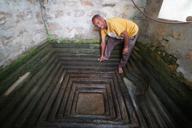
Naula Management and Conservation [Энэтхэг ]
Naulas are shallow, four-sided stepped wells designed to collect water from subterranean seepages or springs and are used to meet domestic water needs by the local communities. Naula management and conservation encompasses a range of activities that preserve their structure and function.
- Мэдээлэл цуглуулсан: Jaclyn Bandy
2. ГТМ Технологийн тодорхойлолт
2.1 Технологийн товч тодорхойлолт
Технологийн тодорхойлолт:
Recharge ponds (Chaals or khals) and recharge trenches (khanti) are common methods to catch the surface runoff and increase the infiltration to recharge groundwater and aid in natural spring recharge in the middle mountain regions.
2.2 Технологийн дэлгэрэнгүй тайлбар
Тодорхойлолт:
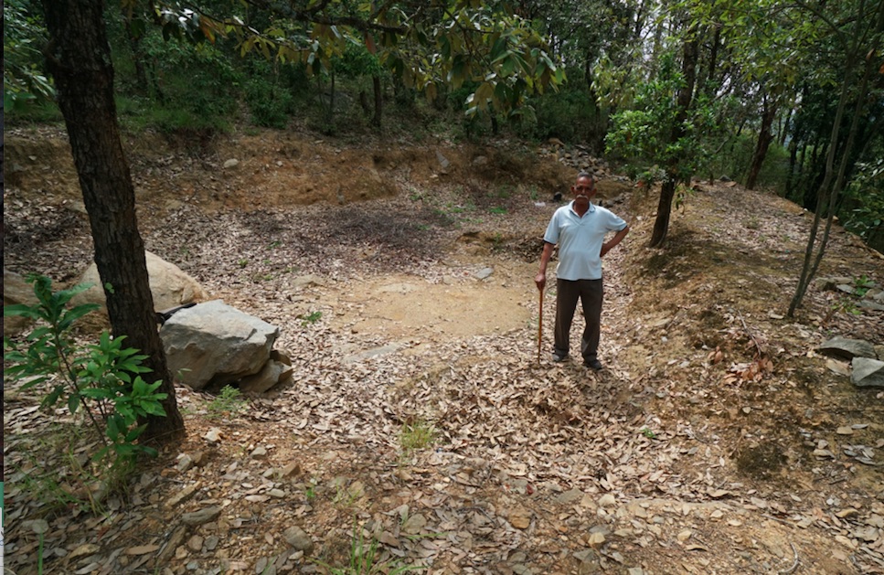
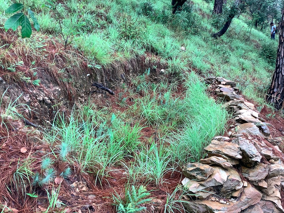
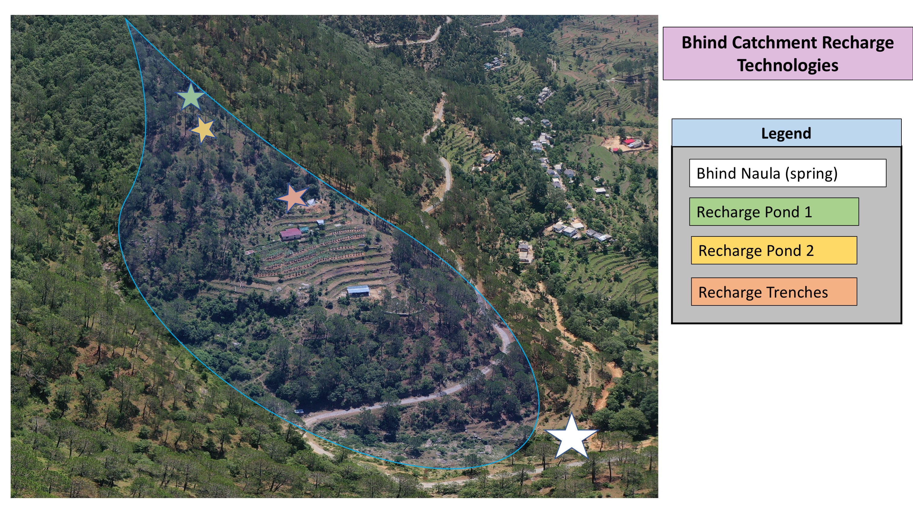
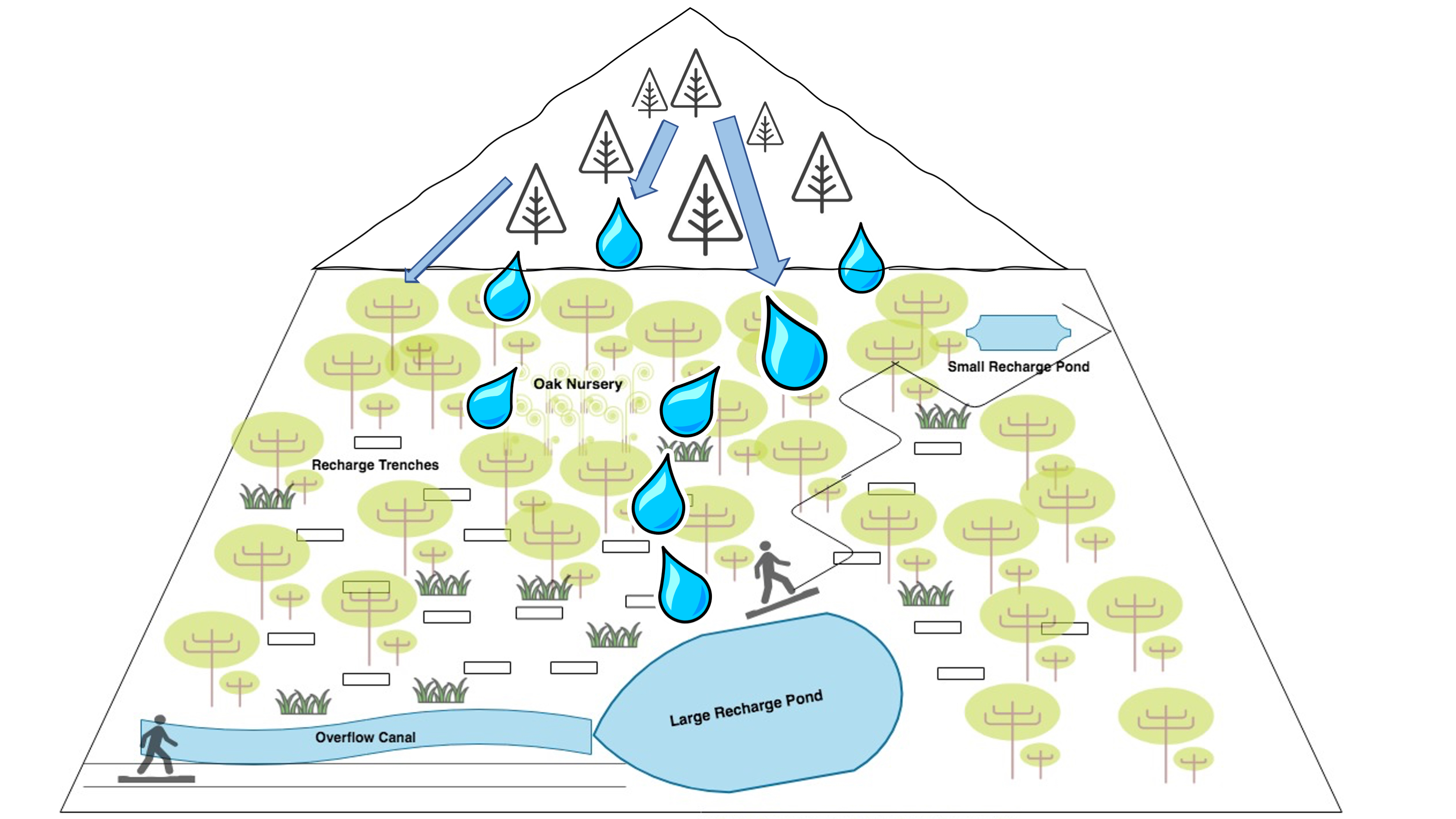
1. The recharge ponds and trenches have been applied in mountainous community forests. There have been about 60 trenches, 1 large and 4 small recharge ponds constructed in the specific sites in the community forest of Naikina. These are ideal areas to implement these technologies, as they encompass the microwatershed/springsheds of 3 springs.
a. Recharge ponds are circular or rectangular dugout structures which were constructed a natural depression area on sloping land. The standard size is usually as follows: Length =3 m, Width =3 m and Depth = 0.7 m, with site specific modifications. Water feeder channels which flow to the ponds helps to harvest additional surface flow. The walls are not vertical but have a 45 degree slope to prevent cave in.
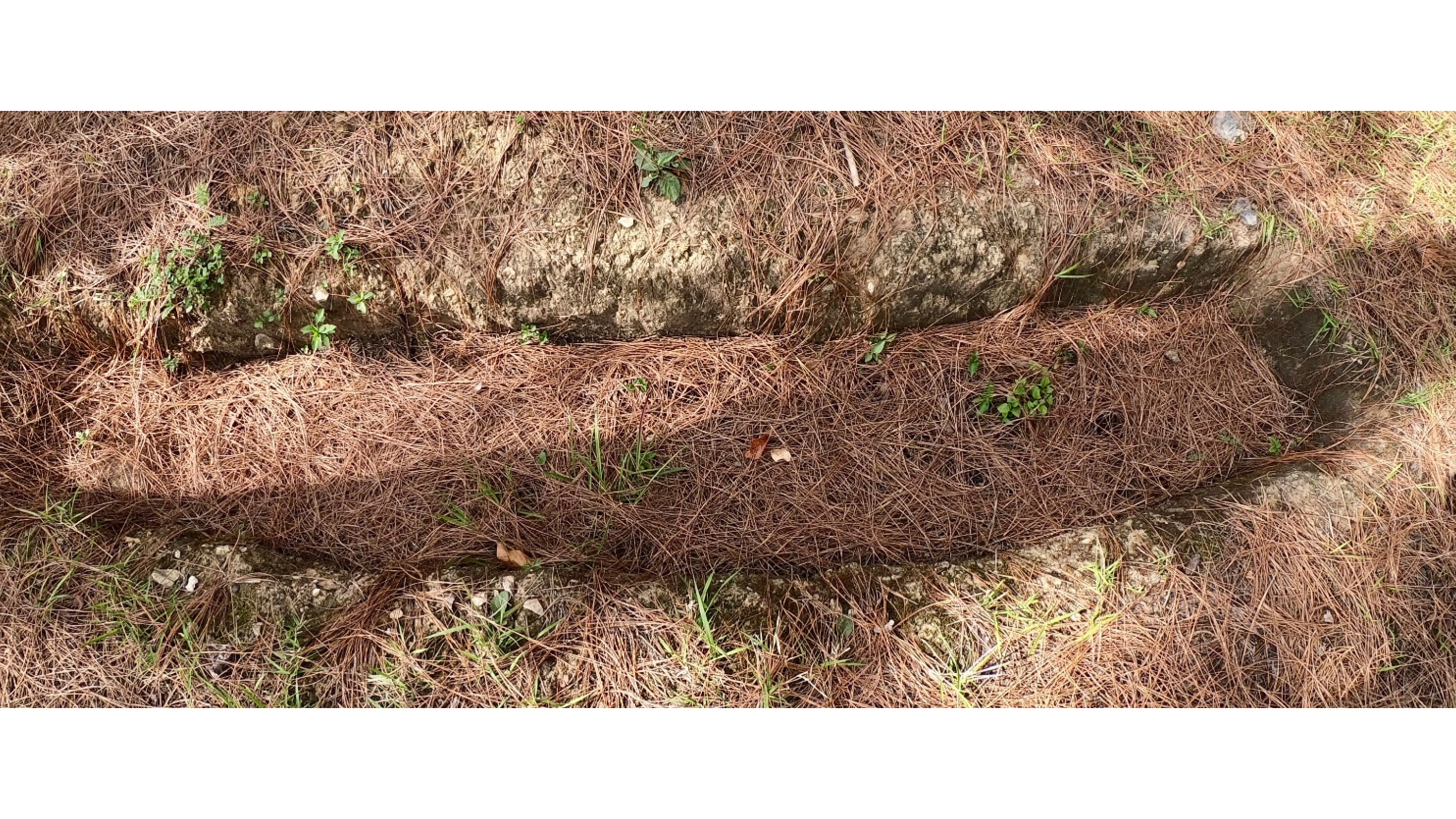
b.Recharge trenches are small rectangular structures of typical dimensions: Length=1.5 m, Width= 1m , Depth= 0.7 m, constructed on sloping land in a staggered manner. The slope of the walls should be not more than 45 degrees, and the size of the trenches and their spacing depends on the slope of the land. In higher slope areas, one should construct smaller staggered trenches with closer spacing. These are generally made in high rainfall areas, as there is an increased danger of overflow. In staggered trenching, the trenches are located directly below one another in alternate rows and in a staggered fashion. These may be 2 m to 3 m long and the spacing between the rows may vary from 3 m to 5 m.
2. Aims/Objectives: The central focus of the technology is water conservation and harvesting of surplus monsoon runoff to recharge groundwater reservoirs, which is otherwise going un-utilized. Additionally, land degradation by water erosion is decreased due to slowing of runoff and increased soil infiltration. Water erosion after intense rainfall affects both onsite and offsite sites, causing soil displacement, increased frequency of landslides, damage to vegetation, agriculture land, and village settlements.
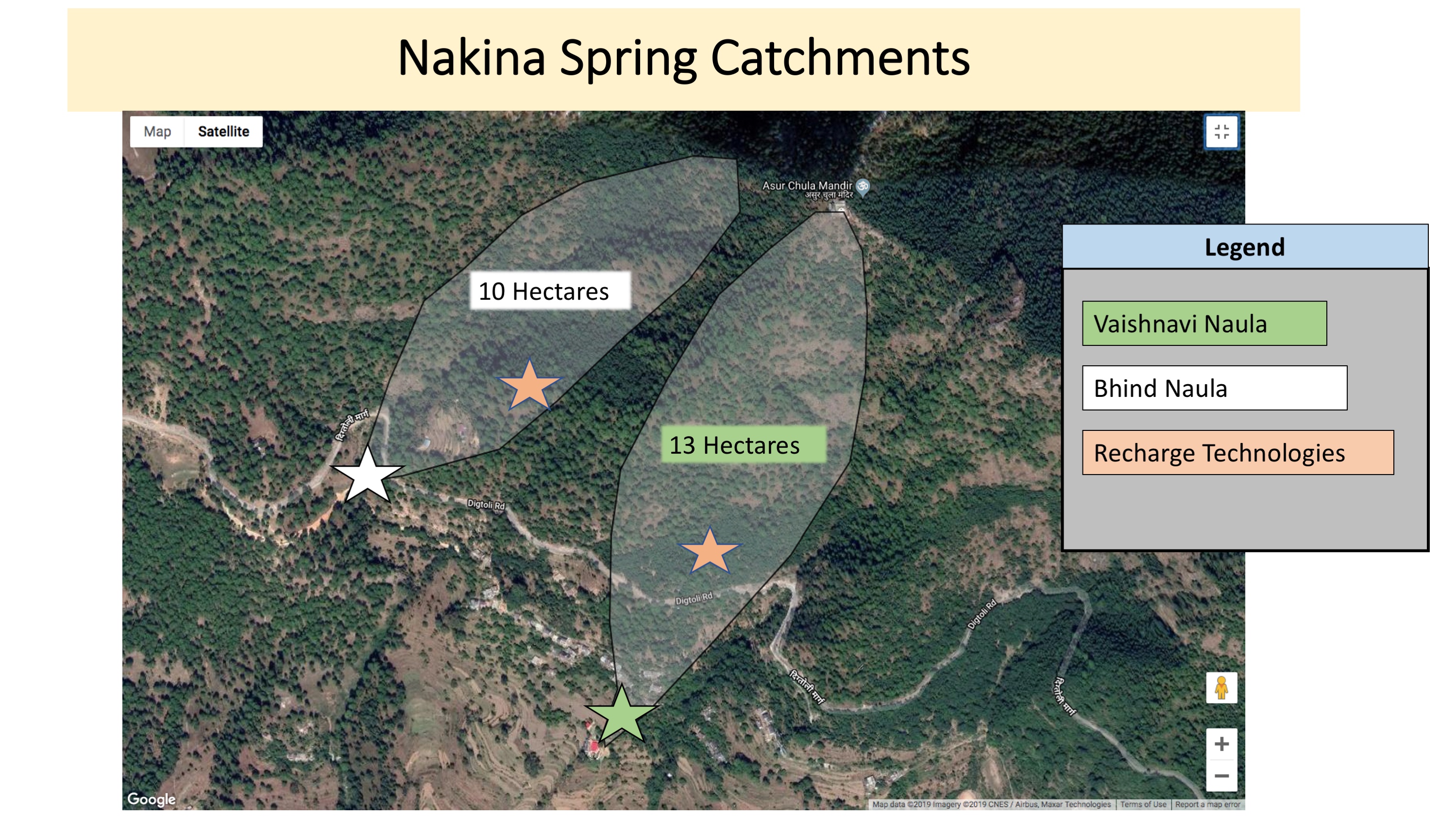
3. Methods: Due to decreased spring discharge in the dry season and high dependency on the springs for drinking water (humans and livestock), the community has implemented these technologies within in catchment areas of 3 essential springs (Bhind, Vaishnavi, and Bagawoti) in the last 3 years.
4. Stages of Implementation: Awareness building, community mobilization, and central planning was done by the head of the Forest Council (Gram Panchayat), Mr. Jagdamba Joshi. Recharge pond and trench construction was done over the course of a month by different villagers that were available to participate. They were incentivized to work with a small compensation of 5.30 USD (400 INR)/day. Activities and inputs included time and manual labor (about 3 days for the large recharge pond, 0.5-1 day for each of the small recharge ponds, and 4 days for 60 recharge trenches) and appropriate land-use planning and management. Primarily, the strategic construction of these technologies and selection in appropriate springshed recharge/catchment areas has led their success. The structures have been placed below the pine forest, (which generates high runoff) and reside in a restored broadleaf forest, which acts like a sponge to retain the runoff water flowing down from the pine forest above. The ponds lies in a natural, leveled depression with gentle slopes around. Broadleaf/oak dominated forest areas have been increasingly supported as technology construction sites, as the placement further improves of groundwater recharge.
To assure long-term effectiveness, maintenance and re-digging of the recharge ponds and trenches is carried out by villagers annually, pre-monsoon.
5. Gram Panchayat, Mr. Joshi has played a key role in informing the villagers of technology design, function and importance for supporting the community forest and subsequent spring recharge. He has previous knowledge of the application of these technologies through first-hand experiences working in the army. The villagers were solely responsible for construction with Mr. Joshi's guidance. The men were mainly responsible for making recharge ponds and the women dug trenches and removed weeds.
6) Technology benefits/impacts acknowledged by the community: moisture conservation, long-term groundwater recharge, spring recharge, reduction of soil-water erosion, improved infiltration and support for vegetation cover and broadleaf/oak forest.
Like: Relatively simple and inexpensive, little external inputs required, effective in short and long-term (provided site appropriate selection and regular seasonal rainfall)
Dislike: Drudgery, time consuming, maintenance required, distance (site of implementation may also be far from village).
2.3 Технологийн гэрэл зураг
Медиа галерей
2.5 Энэ үнэлгээнд хамрагдсан технологийг хэрэгжүүлсэн улс орон / бүс нутаг / байршил
Улс :
Энэтхэг
Улс/аймаг/сум:
Uttarakhand
Байршлын дэлгэрэнгүй тодорхойлолт:
Nakina Village, Pithoragarh Bloc
Технологи өргөн дэлгэрсэн эсхийг тодорхойл:
- тодорхой газар хэрэгжсэн/ жижиг талбайд төвлөрсөн
Технологи(иуд) нэвтрүүлсэн талбай байнгын хамгаалалттай газар нутагт байрладаг уу?
Тийм
Хэрэв тийм бол, тодруулна уу:
The technologies are located in a community protected forest, which has been under sole village management since the early 1950's.
Тайлбар:
A large and small recharge pond above the roadside lies adjacent to a protected oak nursery.
Map
×2.6 Хэрэгжих огноо
Хэрэгжүүлсэн он:
2016
2.7 Технологийн танилцуулга
Технологийг хэрхэн нэвтрүүлснийг тодорхойл:
- Газар ашиглагчдын санаачилгаар
- Гадны төсөл/хөтөлбөрийн дэмжлэгтэйгээр
Тайлбар (төслийн төрөл г.м.):
Mr. Jagdamba Joshi's self-started initiative in his community can be attributed to his personal work experience. While serving in the army, he was trained to build ponds and trenches. Through his own observations and perception of these technologies, he was certain they would help support the depleting groundwater.
3. ГТМ технологийн ангилал
3.1 Технологийн үндсэн зорилго (д)
- Газрын доройтлыг бууруулах, сэргийлэх, нөхөн сэргээх
- Экосистемийг хамгаалах
- Сав газар / доод урсгалыг хамгаалах - бусад технологитой хослуулах
- гамшгийн эрсдлийг бууруулах
- Уур амьсгалын өөрчлөлт/ эрс тэс байдал болон түүний нөлөөлөлд дасан зохицох
- Нийгэмд үзүүлэх үр нөлөөг бий болгох
3.2 Технологи хэвтрүүлсэн газрын одоогийн газар ашиглалтын хэлбэр(д)
Нэг газр нутгийн хэмжээнд хэрэгжих холимог газар ашиглалт:
Тийм

Байгалийн ой / модтой газар
- (Сайжруулсан) байгалийн ой/мод бүхий газар
- Мод тарисан, шинээр ойжуулсан
(Хагас)байгалийн ой/тармаг ойд: Менежментийн төрлийг тодорхойлно уу:
- Сонголттой огтлол
(Хагас)байгалийн ойн төрөл:
- субтропикийн уулт тогтолцооны байгалийн ургамалжилт
- Broadleaf/pine mixed forest
Мод тарих, модгүй газрыг ойжуулах: төрөл зүйлийн гарал үүсэл болон бүтцийг тодорхойлох:
- Холимог төрөл зүйл
Мод тарьсан, шинээр ойжуулсан газрын төрөл:
- субтропикийн хуурайсаг ойн плантаци - өргөн навчит мод
- Quercus leucotrichophora, Quercus lanata, Quercus semecarpifolia, , Quercus glauca Thumb, Pyrus pasia, Myrica eaculanta and Rhododendron arborium
Дээр дурьдсан модны төрөл навч, шилмүүсээ гөвдөг үү эсвэл мөнх ногоон уу?
- навч, шилмүүсээ гөвдөг
Бүтээгдэхүүн ба үйлчилгээ:
- Мод бэлтгэл
- Түлшний мод
- Байгалийн нөөцийг хамгаалах
3.3 Технологи хэрэгжүүлснээс газар ашиглалтад өөрчлөлт гарсан уу?
Технологи хэрэгжүүлснээс газар ашиглалтад өөрчлөлт гарсан уу?
- Үгүй (3.4 хариулт руу шилжинэ үү)
3.4 Усан хангамж
Технологи хэрэгжүүлсэн газрын усан хангамж:
- Байгалийн усалгаатай
3.5 Технологи ГТМ-ийн аль бүлэгт хамаарах
- Ус хураах
3.6 Технологийг бүрдүүлэх ГТМ арга хэмжээ

Барилга байгууламжийн арга хэмжээ
- S4: Шаталсан шуудуу, нүх, хэвгий
- S5: Далан, хотгор, цөөрөм
3.7 Технологийн шийдвэрлэсэн газрын доройтлын үндсэн төрлүүд

Хөрс усаар эвдрэх
- Wt: Хөрсний гадаргын угаагдал
- Wg: Гуу жалгын элэгдэл
- Wm: Хөрсний нуралт, шилжилт
- Wo: Усны элэгдлийн дам нөлөө

Усны доройтол
- Hs: Гадаргын усны хэмжээ багасах
- Hg: Гүний ус / усан судалт давхаргын түвшин өөрчлөгдөх
3.8 Газрын доройтлоос урьдчилан сэргийлэх, сааруулах ба нөхөн сэргээх
Газрын доройтолтой холбоотойгоор Технологи ямар зорилго тавьсан болохыг тодорхойл:
- Газрын доройтлыг багасгах сааруулах
- Хүчтэй доройтсон газрыг нөхөн сэргээх/ сайжруулах
4. Техникийн нөхцөл, хэрэгжилтийн үйл ажиллагаа, материал ба зардал
4.1 Технологийн техникийн зураг
Техник тодорхойлолт (техник зурагтай уялдана):
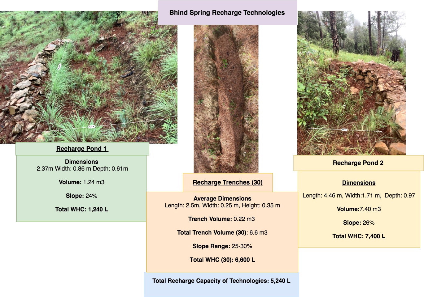
Bhind Catchment (Springshed) Recharge Technologies
Dimensions
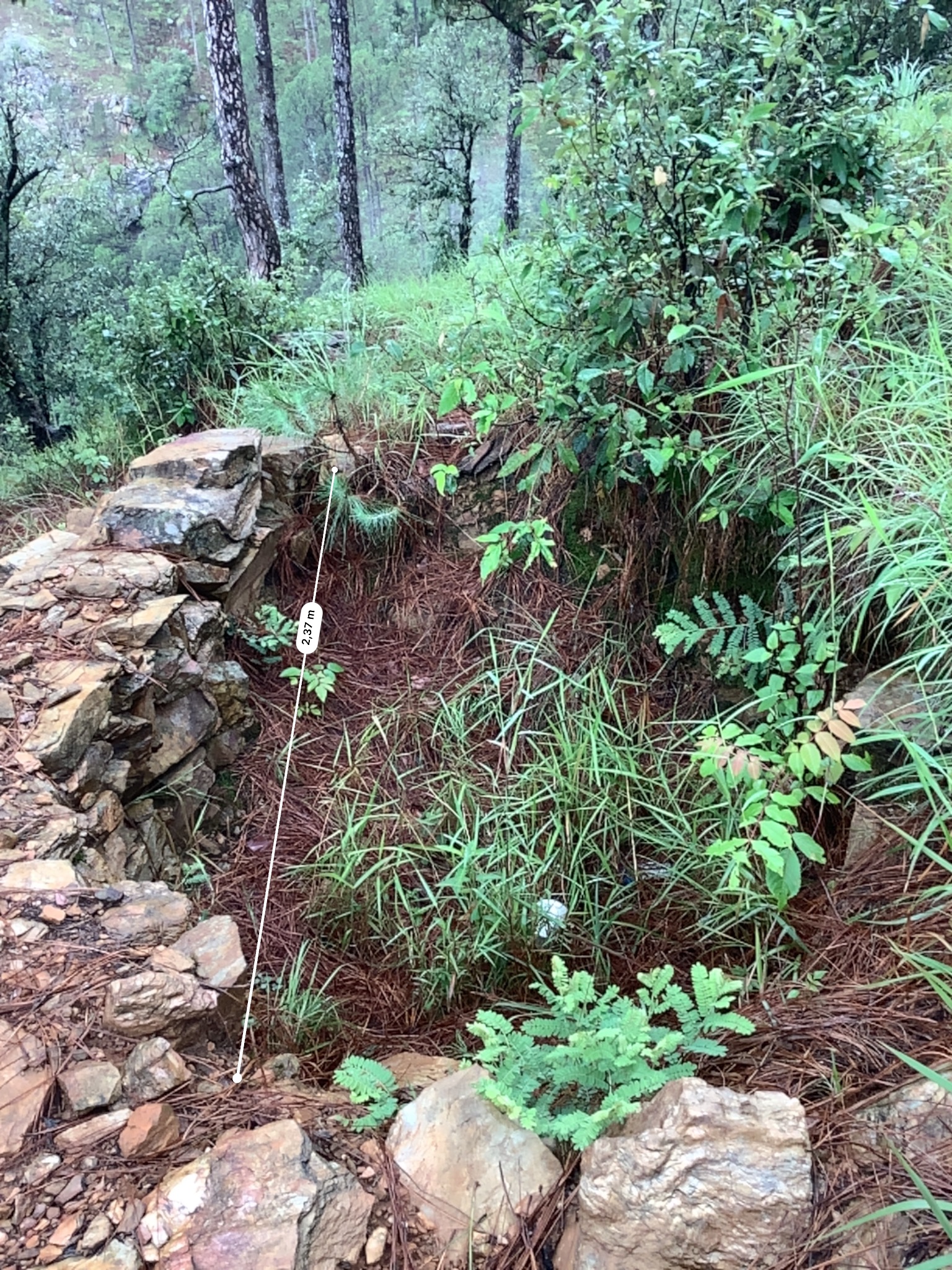
Recharge Pond 1- Length: 2.37m Width: 0.86 m Depth: 0.61m
Pond 1 Volume- 1.24 m3
Slope: 24%
Recharge Pond 2- Length: 4.46 m, Width: 1.71 m, Depth: 0.97
Pond 2 Volume- 7.40 m3
Slope: 26%
Recharge Trench- Length: 2.5m, Width: 0.25 m, Height: 0.35 m
Trench Volume: 0.22 m3
Total Trench Volume (30): 6.6 m3
Spacing: Trenches are in different locations of the Bhind springshed, 20 functional trenches are aggregated within 1m of each other in a broadleaf forest just north on the cucumber farm. 10 trenches are located directly above the Cucumber farm.
Slope Range: 25-30%
Water Holding Capacity (L):
Total Capacity of Recharge Pond 1: 1,240 L
Total Capacity of Recharge Pond 2: 7,400 L
Total Capacity of Trenches (30): 6,600 L
Total WHC of Technologies: 15,240 L
Total Catchment area of Bhind Springshed: ~10 Hectares
Зохиогч:
Jaclyn Bandy
Он, сар, өдөр:
25/07/2019
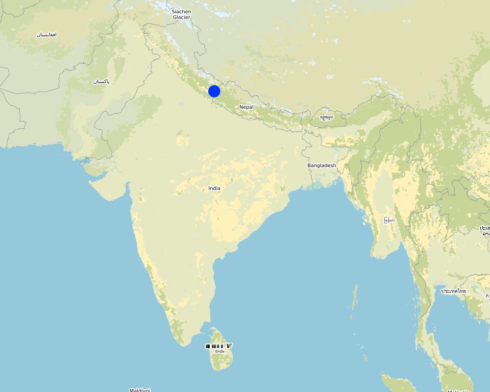
Техник тодорхойлолт (техник зурагтай уялдана):
Bhind Catchment Recharge Technologies: Location Map
Зохиогч:
Jaclyn Bandy
Он, сар, өдөр:
25/07/2019
Техник тодорхойлолт (техник зурагтай уялдана):
Nakina Spring Catchments (springsheds) and Technology Locations
Зохиогч:
Jaclyn Bandy
Он, сар, өдөр:
25/07/2019
Техник тодорхойлолт (техник зурагтай уялдана):
Vaishnavi Recharge Structures Diagram Map
Зохиогч:
Jaclyn Bandy
Он, сар, өдөр:
25/07/2019
Техник тодорхойлолт (техник зурагтай уялдана):
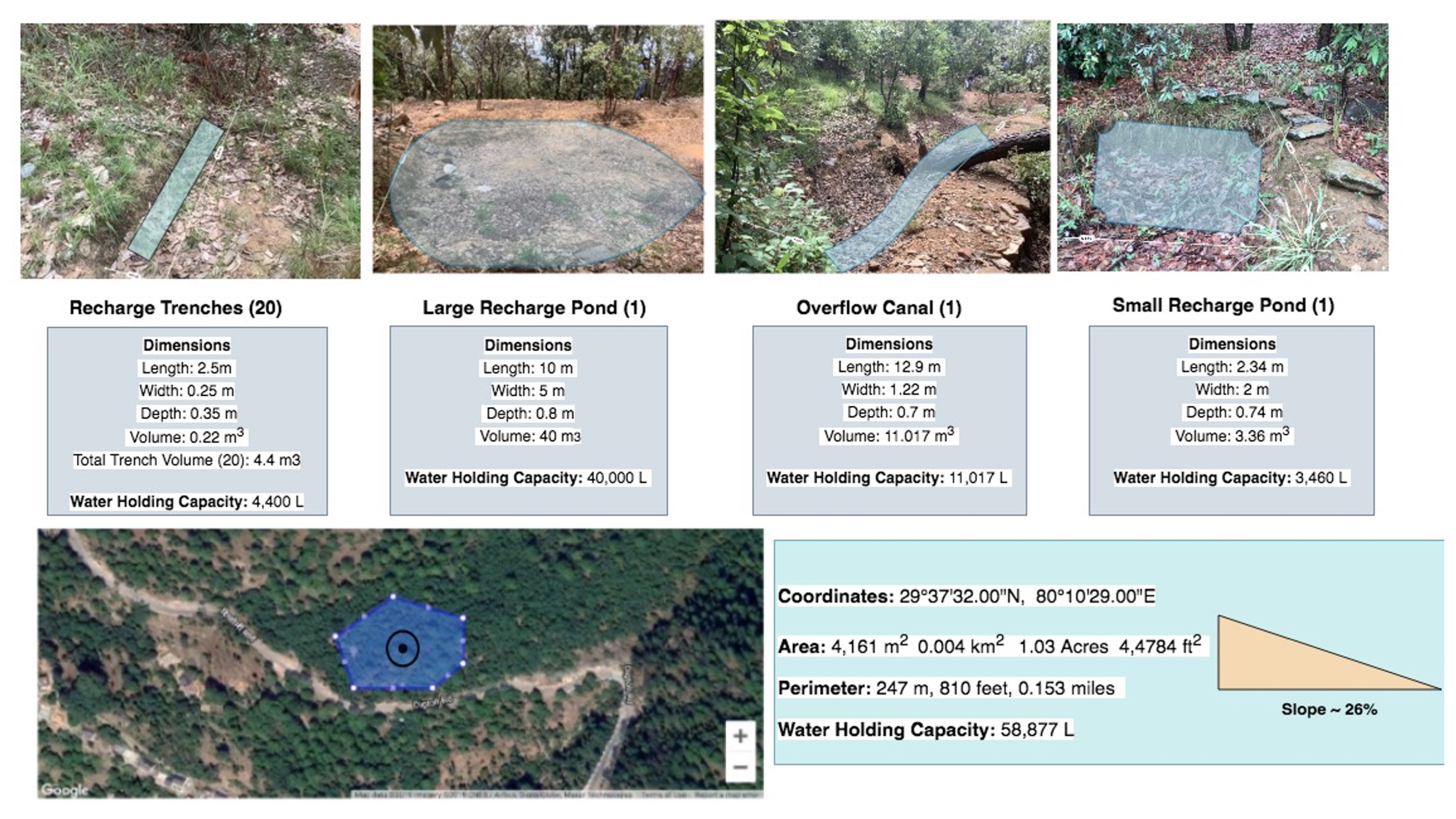
Technologies in Vaishinavi Springshed
Dimensions:
Large Recharge Pond- Length: 10m, Width: 5m, Depth: 0.8 m
Large Pond Volume: 40 cubic meters (m3)
Overflow Canal (narrow pond adjacent to large recharge pond)
Dimensions:
Overflow Canal- Length: 12.9 m, Width: 1.22 m, Depth: 0.7cm
Overflow Canal: 11.017 m3
Small Recharge Pond- Length: 2.34 m, Width: 2 m, Depth: 0.74 m
Small Pond Volume: 3.36 m3
Recharge Trench- Length: 2.5m, Width: 0.25 m, Height: 0.35 m
Trench Volume: 0.22 m3
Total Trench Volume (20): 4.4 m3
Spacing: trenches within 0.5m of each other and <1m spacing between trenches and broadleaf trees and other bushes
Slope: 26%
Water Holding Capacity (L):
Total Capacity of Large Pond: 40,000 L
Total Capacity of Overflow Canal: 11,017 L
Total Capacity of Small Pond: 3,460 L
Total Capacity of Trenches (20): 4,400 L
Total WHC of Technologies: 58,877 L
Total Area of Technologies: 0.5 Hectare
Total Area of Vaishnavi Catchment: ~13 Hectares
Зохиогч:
Jaclyn Bandy
Он, сар, өдөр:
25/07/2019
4.2 Материал болон зардалд хамаарах ерөнхий мэдээлэл
Үнэ өртөг, оруулсан хувь нэмрийг хэрхэн тооцсоныг тодорхойл:
- Технологийн нэгж тус бүр
Нэгжийг тодорхойл:
2 Ponds, 1 Overflow Canal, 20 Recharge trenches
Нэгж хэмжигдэхүүний хэмжих нэгжийн тодорхойлох (шаардлагатай бол):
Total Trenches (20): 4.4 m3, Large Recharge Pond: 40 m3, Overflow Canal: 11.017 m3, Small Recharge Pond: 3.36 m3
бусад/үндэсний мөнгөн нэгж (тодорхойл):
INR
Хэрэв боломжтой бол үндэсний валютын Америк доллартай харьцах харьцааг бичнэ үү (тухайлбал, 1 ам.дол. = 79,9 Бразил реал): 1 ам.дол. =:
70.0
Хөлсний ажилчны нэг өрдийн ажлын хөлсийг тодорхойл:
400 INR
4.3 Байгуулах үйл ажиллагаа
| Үйл ажиллагаа | Хугацаа (улирал) | |
|---|---|---|
| 1. | Plan designed by administrative committee of Van Panchayat | Winter 2016 |
| 2. | For technology construction, groups of men and women (8 total per group) were established with their planned working days | Pre-monsoon 2016 |
| 3. | Trenches and recharge ponds were dug on a rotation system by the groups on different days | Pre-monsoon 2016 |
| 4. | Compensation was given to participants upon completion of the project after 20 days work. | Pre-monsoon 2016 |
4.4 Байгуулалтад шаардагдах зардал ба материал
| Хөрөнгө оруулалтыг дурьдана уу | Хэмжих нэгж | Тоо хэмжээ | Нэгжийн өртөг | Материал бүрийн нийт өртөг | % газар ашиглачаас гарсан зардал | |
|---|---|---|---|---|---|---|
| Хөдөлмөр эрхлэлт | Community manual labor | person-days | 120.0 | 400.0 | 48000.0 | 100.0 |
| Тоног төхөөрөмж | pick | pieces | 5.0 | 300.0 | 1500.0 | 100.0 |
| Тоног төхөөрөмж | shovel | pieces | 5.0 | 500.0 | 2500.0 | 100.0 |
| Тоног төхөөрөмж | pharuwa (hoe) | pieces | 4.0 | 300.0 | 1200.0 | 100.0 |
| Тоног төхөөрөмж | khanti (digging bar) | pieces | 3.0 | 1500.0 | 4500.0 | 100.0 |
| Тоног төхөөрөмж | hammer | pieces | 3.0 | 2000.0 | 6000.0 | 100.0 |
| Тоног төхөөрөмж | small hammer | pieces | 3.0 | 300.0 | 900.0 | 100.0 |
| Тоног төхөөрөмж | chino (chisel) | pieces | 4.0 | 500.0 | 2000.0 | 100.0 |
| Барилгын материал | Rocks excavated on site | |||||
| Технологи бий болгох нийт үнэ өртөг | 66600.0 | |||||
| Технологи бий болгох нийт үнэ өртөг, ам.доллар | 951.43 | |||||
Тайлбар:
On average 4 people worked on establishing the technology/day = 400 x 4 = 1600 (labor cost/day)
1600 x 30 days = 48,000 Total Cost
4.5 Засвар үйлчилгээ / давтагдах үйл ажиллагаа
| Үйл ажиллагаа | Хугацаа/ давтамж | |
|---|---|---|
| 1. | Monitoring of the area for any damages or maintenance required | Weekly |
| 2. | Clearing of debris or filled sediment in pond/trenches/channel | Pre monsoon |
4.6 Засвар үйлчилгээ / урсгал үйл ажиллагаанд шаардагдах зардал ба материал (жилээр)
| Хөрөнгө оруулалтыг дурьдана уу | Хэмжих нэгж | Тоо хэмжээ | Нэгжийн өртөг | Материал бүрийн нийт өртөг | % газар ашиглачаас гарсан зардал | |
|---|---|---|---|---|---|---|
| Хөдөлмөр эрхлэлт | Maintenance Labor | person-days | 4.0 | 1600.0 | 6400.0 | 100.0 |
| Тоног төхөөрөмж | Communal equipment (see above for costs) | |||||
| Технологийг арчилах тордоход шаардагдах нийт үнэ өртөг | 6400.0 | |||||
| Технологи сайжруулах нийт үнэ өртөг, ам.доллар | 91.43 | |||||
4.7 Зардалд нөлөөлж байгаа хамгийн чухал хүчин зүйл
Өртөг зардлыг тодорхойлох гол хүчин зүйлсийг дурьдана уу:
-Amount of siltation accumulated in the recharge structures (more debris/soil accumulation requires more maintenance and labor days)
-Labor availability
5. Хүн, байгалийн хүрээлэн буй орчин
5.1 Уур амьсгал
Жилийн нийлбэр хур тундас
- <250 мм
- 251-500 мм
- 501-750 мм
- 751-1,000 мм
- 1,001-1,500 мм
- 1,501-2,000 мм
- 2,001-3,000 мм
- 3,001-4,000 мм
- > 4,000 мм
Жилийн дундаж хур тунадас (хэрэв мэдэгдэж байвал), мм:
1500.00
Хур тунадасны талаархи тодорхойлолт/ тайлбар:
Monsoon- mid-June to mid-September; July and August are the rainiest months and the temperature is warm and moist; between 70-85% of the annual precipitation occurs in the monsoon season
Seasons
a. Winter or cold weather (mid Dec. - mid March)
b. Summer or hot weather (mid March - mid June)
c. Season of general rains (South - West monsoon season)
d. Season of retreating monsoon (mid September to mid November)
Суурь болгон авсан цаг уурын станцын нэр:
India Meteorological Department, Meteorological Centre Dehradun
Агро-уур амьсгалын бүс
- Хагас чийглэг
The overall climatic condition in the Pithoragarh district is governed by the southwest monsoon. It has a sub-tropical to temperate climate, with three pronounced seasons; summer, winter, and monsoon. The hilly terrain of the Himalayan region has snow cover and is cold during winter with snowfall normally occurring during the months of December to March.
Temperature- The temperature ranges from 0°C to 10°C in winter and from 8°C to 33°C in summer season. However, there is no meteorological observatory in the district. The account of the climate is based mainly on the records of the observations in the neighboring districts where similar meteorological conditions prevail. Variations in temperature are considerable from place to place and depend upon elevation as well as aspect. As the insolation is intense at high altitudes, in summer temperatures are considerably higher in the open than in the shade.
5.2 Байрзүйн зураг
Дундаж налуу:
- Тэгш (0-2 %)
- Бага зэрэг хэвгий (3-5 %)
- Дунд зэрэг хэвгий (6-10 % )
- Долгиорхог (11-15 %)
- Толгодорхог (16-30 %)
- Эгц налуу (31-60 % )
- Огцом эгц налуу (>60 %)
Гадаргын хэлбэр:
- Тэгш өндөрлөг/тэгш тал
- Зоо, хяр
- Уулын энгэр, хажуу
- Ухаа, гүвээ, дов толгод
- Уулын бэл
- Хөндий, хоолой, нам хотос
Өндөршлийн бүс:
- 0-100 м д.т.д
- 101-500 м д.т.д
- 501-1,000 м д.т.д
- 1,001-1,500 м д.т.д
- 1,501-2,000 м д.т.д
- 2,001-2,500 м д.т.д
- 2,501-3,000 м д.т.д
- 3,001-4,000 м д.т.д
- > 4,000 м д.т.д
Технологи дараах асуудалд хандсан эсэхийг тодорхойл:
- хотгор нөхцөл
Гадаргын талаархи тайлбар ба бусад тодорхойлолт:
Average Altitude of evaluated sites: 1850m
Average Slope: 25%
5.3 Хөрс
Хөрсний дундаж зузаан:
- Маш нимгэн (0-20 см)
- Нимгэн (21-50 см)
- Дунд зэрэг зузаан (51-80 см)
- Зузаан (81-120 cм)
- Маш зузаан (>120 cм)
Хөрсний бүтэц (өнгөн хөрс):
- Сийрэг/хөнгөн (элсэрхэг)
- Дунд зэрэг (шавранцар)
Хөрсний бүтэц (>20 см-ээс доош):
- Дунд зэрэг (шавранцар)
Өнгөн хөрсний органик нэгдэл:
- Дунд (1-3 % )
- Бага (<1 % )
Боломжтой бол хөрсний бүрэн тодорхойлолт, боломжит мэдээллийг өгнө үү, жишээ нь хөрсний төрөл, хөрсний урвалын орчин/хүчиллэг байдал, катион солилцох чадавхи, азотын хэмжээ, давсжилт г.м.
Mountain/hill soils are a collective name given to various types of soils found under the following conditions :
-under sub-tropical, temperate and sub-alpine conditions
-under various forest types
Characteristics: very thin, fertile, and may be less than a centimeter deep on steep slopes; they are mixed with pebbles, shingles (a mass of small rounded pebbles), and gravels; they have a low-medium water holding capacity. Angular and subangular fragments of parent rock may be found mixed with the lower layers of the mountain and hill soils.
Texture: varies from loamy to sandy loam.
Soil Reaction: ranges from acidic to neutral (pH 4.6 to 6.5)
Organic Matter content: 1-5%
Ferrugenous red roils are found in this district and are well developed over Himalayan rocks (quartzite, biotite schist, amphibolite schist). They are free of carbonates and deficient in nitrogen, humus and phosphorus, light textured, porous, and friable (brittle/crumbly). The soil depth ranges from about 10cm-75 cm. These soils may be grouped into two on basis of morphology
1. Red earths- loose, friable topsoil rich in secondary concretions (hard, compact mass of matter formed by the precipitation of mineral cement within the spaces between particles, and is found in sedimentary rock or soil)
2. Red loam- argillaceous soils having a blocky structure (argillaceous minerals may appear silvery upon optical reflection and are minerals containing substantial amounts of clay-like components, e.g. argillaceous limestones are limestones consisting predominantly of calcium carbonate, but including 10-40% of clay minerals)
Brown soil: is found particularly under dense broadleaved temperate and sub-alpine forests. There occurs a thick layer of humus on the forest floor (made of decomposed leaves, branches, twigs) and the topsoil is extremely rich in humus
Podsolic Soil: soil that has developed in humid/temperate conditions usually under coniferous forests (e.g. deodar, blue pine, fir, spruce) over quartzite, granites, schists and gneiss.
(Citation: Kumaun: The Land and the People, Sharad Singh Negi (1993)
5.4 Усны хүртээм ба чанар
Хөрсний усны гүн:
5-50 м
Гадаргын усны хүртээмж:
Дунд зэрэг
Усны чанар (цэвэрлээгүй):
Сайн чанарын ундны ус
Усны чанар гэж:
ул хөрсний ус
Усны давсжилт асуудал болдог уу?
Үгүй
Энэ газар үер усанд автдаг уу?
Үгүй
Усны чанар, нөөцийн талаархи тайлбар ба бусад тодорхойлолт:
Quantity: Water crisis has been a perennial problem in both the rural and urban areas of the Pithoragarh district
There is scarcity of safe drinking water of the villages in the study area. Hand pumps are often not functioning, pipe-water schemes are unreliable and the spring discharges have reduced during the dry season. Hand-pumped water often has a high iron content and bitter taste. Poor quality of groundwater in some of the naulas is mainly due to misuse and/or disuse of the structures.
A block-district groundwater resource estimation could not be carried out as the area is hilly (with slope >20%) and in major part aquifers are small, isolated bodies, and groundwater abstraction is done mainly through hand pumps and springs with small discharges.
However, we collected some physicochemical parameters that indicate the water (sourced from springs) is of good quality:
Water Quality Parameters of Springs:
pH: 6.29-8.18
Temp: 19.0-23.5 ºC
Electrical Conductivity: 109-504 µmsiemens
Total Dissolved Solids: 75-385 ppm
Other Parameters (from springs of nearby district, Champawat)
Electrical Conductivity: 127-222 µmsiemens
pH: 7.69-8.24
Calcium: 16-36 mg/l
Magnesium: 4.9-7.3 mg/l
Bicarbonate: 61-134 mg/l
Chloride: 5.3- 8.9 mg/l
Total Hardness as CaCO3: 70-110 mg/l
Source: Government of India Ministry of Water Resources, Central Ground Water Board, 2009 Groundwater Brochure of Champawat District (2009
5.5 Биологийн төрөл зүйл
Зүйлийн олон янз байдал:
- Дунд зэрэг
Амьдрах орчны олон янз байдал:
- Дунд зэрэг
Биологийн олон янз байдлын талаархи тайлбар ба бусад тодорхойлолт:
Uttarakhand has more than 7000 species of medicinal plants and 500 species of fauna. Floral diversity contributes 31% of total floral density of India. Fauna contributes just 1.58% of the total faunal density of the country. There are 119 endemic species of flowering plants in the state that exhibited 2.35% endemism and 35 faunal endemic species. Because it lies at the juncture of India, Nepal and the Tibeten Autononmous region, there often cases of poaching and smuggling of wildlife contrabands, including bear bile, musk pods and leopard skins through the borders. Yarsa Gumba Ophiocordyceps sinensis, commonly known as Caterpillar Fungus, is also illegally traded transboundary in the region, together with various plant species. Due to anthropogenic impacts, changes is soil quality, and climatic elements, the biodiversity of our study site is not as high as in other areas of the Pithoragarh district.
Citation: Sundriyal, M. & Sharma, B. (2016). Status of Biodiversity in Central Himalaya, Applied Ecology and Environmental Sciences, 4( 2), 37-43.
5.6 Технологи нэвтрүүлсэн газар ашиглагчидын онцлог шинж
Суурьшмал эсвэл нүүдлийн:
- Суурьшмал
Үйлдвэрлэлийн системийн зах зээлийн чиг баримжаа:
- Амь зуух арга хэлбэрийн (өөрийгөө хангах)
- холимог (амьжиргаа ба худалдаанд)
Фермээс гадуурх орлого:
- Нийт орлогын % 10-50 хувь
Чинээлэг байдлыг харьцангуй түвшин:
- Ядуу
Хувь хүн эсвэл бүлэг:
- бүлэг / олон нийтийн
Механикжилтын түвшин:
- Хүнд хүчир ажил
Хүйс:
- Эмэгтэй
- Эрэгтэй
Газар ашиглагчийн нас:
- Залуус
- Дунд нас
- Ахимаг нас
5.7 Технологи нэвтрүүлэхэд газар ашиглагчийн ашигласан газрын дундаж талбай
- < 0.5 га
- 0.5-1 га
- 1-2 га
- 2-5 га
- 5-15 га
- 15-50 га
- 50-100 га
- 100-500 га
- 500-1,000 га
- 1,000-10,000 га
- > 10,000 га
Энэ нь жижиг, дунд, том оворт тооцогдох уу (орон нутгийн чиг баримжаагаар)?
- Бага-хэмжээний
5.8 Газар эзэмшил, газар ашиглах эрх, ус ашиглах эрх
Газар өмчлөл:
- Нэгдэл/ тосгон
Газар ашиглах эрх:
- Нэгдлийн хэлбэрээр (зохион байгуулалттай)
Ус ашиглах эрх:
- Нээлттэй хүртэх (зохион байгуулалтгүй)
- Нэгдлийн хэлбэрээр (зохион байгуулалттай)
Газар ашиглалтын эрх уламжлалт эрхзүйн тогтолцоонд суурилдаг уу?
Тийм
Тодорхойлно уу:
Under the Kumaun Panchayat forest rules of 1931 (amended in 1976): the Van Panchayat (community forest council) is formed out of non-private land within the settlement boundaries of a village. Accordingly, all villagers are members of the VP upon their approval by a Sub-Divisional Magistrate under the state Revenue Department. The members are collectively referred to as the general body, which selects the management committee members through a democratic process.
Тайлбар:
5-9 elected members assume control of the forest and the extent of villager use. They additionally raise funds and mobilize the village to protect and support sustainable land use. Presently 12,089 Van Panchayats are entrusted with the management of over 5,449.64 km2 of forests.
5.9 Дэд бүтэц, үйлчилгээний хүртээмж
эрүүл мэнд:
- Ядуу
- Дунд зэргийн
- Сайн
боловсрол:
- Ядуу
- Дунд зэргийн
- Сайн
техник дэмжлэг:
- Ядуу
- Дунд зэргийн
- Сайн
хөдөлмөр эрхлэлт (жишээ нь, ХАА-аас өөр):
- Ядуу
- Дунд зэргийн
- Сайн
зах зээл:
- Ядуу
- Дунд зэргийн
- Сайн
эрчим хүч:
- Ядуу
- Дунд зэргийн
- Сайн
зам ба тээвэр:
- Ядуу
- Дунд зэргийн
- Сайн
ундны ус ба ариутгал:
- Ядуу
- Дунд зэргийн
- Сайн
санхүүгийн үйлчилгээ:
- Ядуу
- Дунд зэргийн
- Сайн
Тайлбар:
The situation of infrastructure is difficult and inconsistent in the hill regions because of the terrain. The major infrastructural issues are drinking water and irrigation facilities, electricity, transportation and communication facilities and social infrastructure (housing and education). As for financial services, only the State Bank of India (SBI) is active in the hill regions where it is trying to achieve the objective of 100% financial inclusion. Some villages mentioned buying into into agricultural insurance in the past, however this was a temporary enterprise and they were never compensated after extreme climatic events that occurred and damaged over 70% of their crop.
Though infrastructure and education has generally improved over the years, institutional and marketing networks in the region aimed at supporting hill-farmers are lacking.
6. Үр нөлөө ба дүгнэлт
6.1 Технологийн талбай дахь үр нөлөө
Нийгэм-эдийн засгийн үр нөлөө
Үйлдвэрлэл
тэжээл үйлдвэрлэл
тэжээлийн чанар
ой/модтой газрын чанар
газрын менежмент
Тайлбар/ тодорхой дурьдах:
Constructing these technologies in the forest and within spring catchment areas has supported the village to work collaboratively and increased overall insightfulness to on-and-offsite effects and potentials of SLM.
Орлого, зарлага
ХАА-н хөрөнгө оруулалтын зардал
Тайлбар/ тодорхой дурьдах:
Decreased the amount of supplementary fodder required for livestock. The amount of grasses, fodder, and fuelwood has increased with the help of strategic placement of recharge ponds and trenches.
хөдөлмөр хүчний хэмжээ
Тайлбар/ тодорхой дурьдах:
Less time spent collecting forest resources, as the area where the technology is near the village and supports fodder/fuelwood growth (broadleaf forest/oak nursery area)
Нийгэм-соёлын үр нөлөө
хүнсний аюулгүй байдал/ өөрийгөө хангах
Тайлбар/ тодорхой дурьдах:
Improved self sufficiency of village, as the technology has helped increase their water availability.
эрүүл мэндийн байдал
Тайлбар/ тодорхой дурьдах:
Water condition has improved. Their is less time spent collecting fodder in the forest, as these technologies have supported fodder tree and grass production.
газар ашиглалт / усны эрх
Тайлбар/ тодорхой дурьдах:
There is less friction between the villages of Bhurimuni and Nakina. Nakina did not have to go ask for permission to access the Bhurimuni Naula for water during the dry season.
Соёлын боломжууд
Тайлбар/ тодорхой дурьдах:
The improvements of forest resource security and resilience to disasters/climatic extremes have allowed the villagers to spend more of their time building up a communal gathering area for ceremonial events and festivals around the Vaishnavi Temple.
амралт, нөхөн сэргээлтийн боломжууд
Тайлбар/ тодорхой дурьдах:
There is more time for the women (1-2 hours saved) as the structural technologies have supported existing vegetation growth. This has reduced the time and distance required for gathering fodder an fuelwood.
олон нийтийн институц
Тайлбар/ тодорхой дурьдах:
The partnerships formed between land-users, the Nakina Van Panchayat, the Forest Department and external institutions are leading examples of necessary cooperation between all levels of governance for project harmonization.
ГТМ/ газрын доройтлын талаархи мэдлэг
Тайлбар/ тодорхой дурьдах:
People are taking forest management seriously and making innovative plans for further SLM interventions, whether it be community-initiated or with the help of external institutions/agencies.
маргааныг шийдвэрлэх
Тайлбар/ тодорхой дурьдах:
Increased availability of resources has helped the overall morale of the village. This has further enhanced cooperation for interventions that require participation and effort in the community forest.
Нийгэм, эдийн засгийн хувьд эмзэг бүлгийнхний нөхцөл байдал
Экологийн үр нөлөө
Усны эргэлт/ илүүдэл
усны хэмжээ
Тайлбар/ тодорхой дурьдах:
The technologies act as a water reservoir and improve water holding capacity of the soil by decreasing runoff velocity.
ус хураах / цуглуулах
гадаргын урсац
илүүдэл ус урсгах
гүний усны түвшин / уст давхарга
ууршилт
Хөрс
хөрсний чийг
хөрсөн бүрхэвч
хөрс алдагдах
хөрс хуримтлагдах
хөрс хагарах/ хагсах
хөрс нягтрах
хөрсний органик нэгдэл/ хөрсөнд агуулагдах С
Тайлбар/ тодорхой дурьдах:
Micro-catchments accumulate debris/silt washed down from upstream areas. When managed properly, this can function as a beneficial mulch to the soil, improving bioavailabiltiy of nutrients for plants.
Биологийн: ургамал, амьтан
Ургамал бүрхэвч
Тайлбар/ тодорхой дурьдах:
Improved water availability and thus potential/support for vegetation growth and cover.
газрын дээрхи / доорхи С
Тайлбар/ тодорхой дурьдах:
Improves grasses and vegetation growth, and collects debris/silt from upstream areas.
ургамлын төрөл, зүйл
Тайлбар/ тодорхой дурьдах:
Micro-catchments provide water for native grasses, vegetation, and can help with the germination of seeds.
амьтны төрөл, зүйл
Тайлбар/ тодорхой дурьдах:
Micro-catchments provide water and habitat for small animals/birds.
Ашигт төрөл зүйл
Тайлбар/ тодорхой дурьдах:
Micro-catchments provide water, habitat, and protection for microorganisms and insect species. They support native grasses and vegetation.
амьдрах орчны олон янз байдал
Уур амьсгал болон гамшгийн эрсдлийг бууруулах
хөрсний гулсалт/ чулуун нуранги
Тайлбар/ тодорхой дурьдах:
Decreased surface flow velocity
гангийн нөлөө
Тайлбар/ тодорхой дурьдах:
Improved groundwater availability and enhanced spring recharge
циклон, бороо, шуурганы нөлөө
Тайлбар/ тодорхой дурьдах:
Erosion impacts from extreme rain storms is reduced by decreasing flow velocity
түймрийн эрсдэл
Тайлбар/ тодорхой дурьдах:
Area is protected and forest is further enhanced by improved groundwater availability
бичил уур амьсгал
Тайлбар/ тодорхой дурьдах:
Decreased surface temperature due to improved vegetation/biomass, soil cover and water availability.
6.2 Технологийн талбайн гадна үзүүлсэн үр нөлөө
Усны хүртээмж
Тайлбар/ тодорхой дурьдах:
Improved spring discharge in the peak dry season
хуурай улиралд ашиглах найдвартай, тогтвортой урсгал
Тайлбар/ тодорхой дурьдах:
Bhind and Vaishnavi Naulas (springs) have improved discharge in the peak dry season. According to villagers, there was little to no water available in May/June, and since 10 years the flow has returned due to improved forest management in combination with these structural technologies.
Доод урсгалын үер
Тайлбар/ тодорхой дурьдах:
impact of flash flood is minimized
урсацын адагт лаг шавар хуримтлагдана
Тайлбар/ тодорхой дурьдах:
Helped slow down sediment and runoff
газар доорхи ус/голын усны бохирдол
Тайлбар/ тодорхой дурьдах:
No direct evidence, but statements from the locals indicate that there are less sediments in the spring water ( due to improved soil infiltration and buffering capacity)
буферлэх / шүүлтүүрийн багтаамж
хөрш зэргэлдээ газарт учирах хохирол
Тайлбар/ тодорхой дурьдах:
Less damage from runoff
нийтийн/хувийн хэвшлийн дэд бүтцэд учируулах хохирол
Тайлбар/ тодорхой дурьдах:
Decreased intensity of runoff on the roadside and settlement below
6.3 Технологийн уур амьсгалын өөрчлөлт ба Уур амьсгалаас хамаарах аюул/гамшигт үзэгдэлд өртөх байдал ба эмзэг байдал (газар ашиглагч нарын дүгнэлтээр)
Уур амьсгалын аажим өөрчлөлт
Уур амьсгалын аажим өөрчлөлт
| Улирал | Өсөх эсвэл буурах | Технологи түүний нөлөөг хэрхэн бууруулж байна? | |
|---|---|---|---|
| Жилийн дундаж температур | Өсөлт | Сайн | |
| Жилийн дундаж хур тундас | Бууралт | Дунд зэрэг | |
| Бусад аажим уур амьсгалын өөрчлөлч | Intensity of rainfall in wet season | Өсөлт | Сайн |
Уур амьсгалаас хамаарах аюулууд (гамшигууд)
Цаг уурын гамшигууд
| Технологи түүний нөлөөг хэрхэн бууруулж байна? | |
|---|---|
| Орон нутгийн аадар бороо | Маш сайн |
| Орон нутгийн аянга цахилгаантай бороо | Сайн |
| Орон нутгийн мөндөртэй бороо | Сайн |
| Орон нутгийн цасан шуурга | Мэдэхгүй |
| Орон нутгийн салхин шуурга | Сайн |
Уур амьсгалын гамшигууд
| Технологи түүний нөлөөг хэрхэн бууруулж байна? | |
|---|---|
| Дулааны долгион | Сайн |
| Ган гачиг | Сайн |
| Ойн түймэр | Сайн |
Гидрологийн гамшиг
| Технологи түүний нөлөөг хэрхэн бууруулж байна? | |
|---|---|
| Шар усны үер | Дунд зэрэг |
| Хөрсний гулсалт | Дунд зэрэг |
Тайлбар:
The functionality of the technology depends on its maintenance. For example, after an extreme hydrological event such as a rainstorm, the trenches and ponds can fill up with sediment and debris. If the structures are not maintained and reconstructed after such damaging events, they lose their purpose.
Similarly, if there is no rain and extreme drought, the structure may be intact with no maintenance. However with no water to collect, the technology has little use.
6.4 Зардал ба үр ашгийн шинжилгээ
Үр ашгийг барилга байгууламжийн зардалтай (газар ашиглагчдын үзэл бодлоор) хэрхэн харьцуулах вэ?
Богино хугацаанд эргэн төлөгдөх байдал:
Дунд зэрэг
Урт хугацаанд эргэн төлөгдөх байдал:
Маш эерэг
Үр ашгийг засвар үйлчилгээ/ урсгал зардалтай (газар ашиглагчдын үзэл бодлоор) хэрхэн харьцуулах вэ?
Богино хугацаанд эргэн төлөгдөх байдал:
Дунд зэрэг
Урт хугацаанд эргэн төлөгдөх байдал:
Маш эерэг
Тайлбар:
Due to these interventions, spring discharge has improved in the dry season. As villagers are highly reliant on these springs, this has had a huge impact on the community. Establishment and maintenance costs are extremely low compared to the benefits.
6.5 Технологи нутагшуулах
- 11-50%
Боломжтой бол, тоогоор илэрхийл (өрхийн тоо эсвэл бүрхэх талбай):
In combination with the efforts of the Uttarakhand Forrest Department, under the Tata Water Mission (an initiative of Tata Trusts) 312 villages (out of 1,724) in Pithoragarh district have successfully implemented springshed management projects. They adopted a catchment area approach by identifying sources of springs, understanding their history and reason for decreased discharge before identifying areas that need to be rejuvenated.
Технологийг өөрийн талбайд нэвтрүүлсэн бусад иргэдээс хэд нь үүнийг өөрийн хүчээр, өөрөөр хэлбэл ямар нэг материал, техникийн дэмжлэг, төлбөр авалгүй хийсэн бэ?
- 0-10%
Тайлбар:
Land users received an incentive of 5.30 USD (400INR), which is provided by funds that lie in the joint account between the Van Panchayat and the Uttarakhand State Forest Department. The community has limited access to these funds, and consent is needed to withdraw money for community forest related activities. Due to the time and drudgery to establish the technologies in the appropriate zone (usually far from the village, in the upper catchment area), many villagers will not willingly go out digging trenches and recharge ponds in the forest without incentives or exemplary evidence that these structures will give tangible or immediate benefits.
6.6 Дасан зохицох
Хувьсан өөрчлөгдөж буй нөхцөл байдалд Технологид сүүлд ямар нэг шинэчлэл хийгдсэн үү?
Тийм
Хэрэв тийм бол ямар өөрчлөлтийг даван туулахад шинэчлэл хийгдсэн бэ?
- уур амьсгалын өөрчлөлт/ эрс тэс байдал
Технологийн дасан зохицох байдлыг тодорхойл (хийц, материал, төрөл зүйл г.м.):
Water channels were made to direct runoff into the large recharge pond.
6.7 Технологийн давуу тал/боломжууд
| Газар ашиглагчдын тодорхойлсон давуу тал/боломжууд |
|---|
| Reduces erosion, improves catchment of runoff, increases groundwater availability and aids in spring recharge. |
| Supports soil quality and broadleaf forest growth through increased infiltration, improved soil moisture and water availability. |
| Reduces impact of landslides and further downstream damage to settlements (water erosion, siltation) |
| Эмхэтгэгч, бусад мэдээлэл өгсөн хүмүүсийн өнцгөөс тодорхойлсон давуу тал/боломжууд |
|---|
| Views aligned with land user |
6.8 Технологийн дутагдалтай/сул тал/аюул болон тэдгээрийн хэрхэн даван туулах арга замууд
| Газар ашиглагч нарын тодорхойлсон сул тал/ дутагдал/ эрсдэл | Тэдгээрийг хэрхэн даван туулах вэ? |
|---|---|
| Structural damage of technologies due to extreme hydrological events | Maintenance after such events and application of vegetative measures to complement. Combine with conservation practices like mulching to aid infiltration and deceleration of runoff speed. |
| Function of technologies are lost when there is no rainfall | In general, biological interventions are necessary to aid groundwater recharge in the area. However, due to increased vegetation cover, soil moisture and available organic matter can be conserved in times of drought. |
| Эмхэтгэгч, бусад мэдээлэл өгсөн хүмүүсийн өнцгөөс тодорхойлсон сул тал/ дутагдал/ эрсдэл | Тэдгээрийг хэрхэн даван туулах вэ? |
|---|---|
| Function of the technologies can be compromised with inappropriate design, site selection, or quantification of the area necessary for significant groundwater recharge (e.g. amount of recharge pond and trenches). | Training and awareness about the limitations of this technology should be known and made aware by supporting agencies. Selection of catchment areas for springsheds and catchment calculations need to be assessed. Additionally, onsite experts should be provided during implementation. |
7. Ном зүй ба холбоосууд
7.1 Мэдээллийн аргууд / эх сурвалжууд
- Хээрийн уулзалт, судалгаа
Villages: Naikina, Digtoli, Bhurmuni, Talli Seam, Malli Seam
- Газар ашиглагчтай хийсэн ярилцлага
1.Gram Panchayat (Head of Forest Council)
2. Former Village Head
3. Community group discussions (FDGs)
- ГТМ-ийн мэргэжилтэн/шинжээчтэй хийсэн ярилцлага
1. Uttarakhand Forest Department
2. Local NGO Himalayan Sewa Samiti, CHEA
3. G.B. Pant researchers and project implementers
- тайлан болон бусад эх сурвалжийн бүрдэл
Мэдээллийг хэзээ (газар дээр нь) цуглуулсан бэ?
04/07/2019
Тайлбар:
Field data duration: June 2019-July 2019
7.3 Холбогдох мэдээллийн интернет холбоос
Гарчиг/ тодорхойлолт :
Dhara Vikas Handbook: A User Manual for Springshed Development to Revive Himalayan Springs
URL:
https://www.indiawaterportal.org/news/dhara-vikas-handbook-user-manual-springshed-development-revive-himalayan-springs
Гарчиг/ тодорхойлолт :
Protocol for Reviving Springs in the Hindu Kush Himalaya: A Practitioner’s Manual
URL:
http://lib.icimod.org/record/34040/files/SpringManual04-2018.pdf
Гарчиг/ тодорхойлолт :
Reviving Dying Springs: Climate Change Adaptation Experiments From the Sikkim Himalaya
URL:
https://www.researchgate.net/publication/273670290_Reviving_Dying_Springs_Climate_Change_Adaptation_Experiments_From_the_Sikkim_Himalaya
Гарчиг/ тодорхойлолт :
Assessing Landscape Restoration Opportunities for Uttarakhand, June 2018
URL:
https://www.iucn.org/sites/dev/files/content/documents/uttarakhand_restoration_opportunities_assessment_report_june_20181.pdf
Гарчиг/ тодорхойлолт :
Stories of Success- narratives from a sacred land
URL:
http://lib.icimod.org/record/32844/files/SuccessStory.pdf
Холбоос ба модулууд
Бүгдийг харуулах Бүгдийг хаахХолбоосууд
Community Forest Management in the Nakina Van Panchayat [Энэтхэг ]
Van Panchayats or village forest councils are a impressive example of grassroots community management of natural resources, where a specific administrative unit is locally elected by community members who are responsible for the management of activities related to the forest.
- Мэдээлэл цуглуулсан: Jaclyn Bandy
Naula Management and Conservation [Энэтхэг ]
Naulas are shallow, four-sided stepped wells designed to collect water from subterranean seepages or springs and are used to meet domestic water needs by the local communities. Naula management and conservation encompasses a range of activities that preserve their structure and function.
- Мэдээлэл цуглуулсан: Jaclyn Bandy
Модулууд
Модуль байхгүй байна