Recharge Ponds and Recharge Trenches [ប្រទេសឥណ្ឌា]
- ការបង្កើត៖
- បច្ចុប្បន្នភាព
- អ្នកចងក្រង៖ Jaclyn Bandy
- អ្នកកែសម្រួល៖ –
- អ្នកត្រួតពិនិត្យច្រើនទៀត៖ Hanspeter Liniger, Rima Mekdaschi Studer
Chaal or Khals (recharge pond) and Khanti (recharge trenches)
technologies_5193 - ប្រទេសឥណ្ឌា
ពិនិត្យមើលគ្រប់ផ្នែក
ពង្រីកមើលទាំងអស់ បង្រួមទាំងអស់1. ព័ត៌មានទូទៅ
1.2 ព័ត៌មានលម្អិតពីបុគ្គលសំខាន់ៗ និងស្ថាប័នដែលចូលរួមក្នុងការវាយតម្លៃ និងចងក្រងឯកសារនៃបច្ចេកទេស
បុគ្គលសំខាន់ម្នាក់ (ច្រើននាក់)
អ្នកប្រើប្រាស់ដី:
Joshi Jagdamba Prashad
Naikina Forest Head Council (Gram Panchayat)
ប្រទេសឥណ្ឌា
ឈ្មោះគម្រោងដែលបានចងក្រងឯកសារ/ វាយតម្លៃលើបច្ចេកទេស (បើទាក់ទង)
Onsite and Offsite Benefits of SLMឈ្មោះអង្គភាពមួយ (ច្រើន) ដែលបានចងក្រងឯកសារ/ វាយតម្លៃបច្ចេកទេស (បើទាក់ទង)
ICIMOD International Centre for Integrated Mountain Development (ICIMOD) - ប្រទេសនេប៉ាល់ឈ្មោះអង្គភាពមួយ (ច្រើន) ដែលបានចងក្រងឯកសារ/ វាយតម្លៃបច្ចេកទេស (បើទាក់ទង)
G.B. Pant Institute of Himalayan Einvironment & Development (G.B. Pant Institute of Himalayan Einvironment & Development) - ប្រទេសឥណ្ឌា1.3 លក្ខខណ្ឌទាក់ទងទៅនឹងការប្រើប្រាស់ទិន្នន័យដែលបានចងក្រងតាមរយៈ វ៉ូខេត
អ្នកចងក្រង និង(បុគ្គលសំខាន់ៗ)យល់ព្រមទទួលយកនូវលក្ខខណ្ឌនានាទាក់ទងទៅនឹងការប្រើប្រាស់ទិន្នន័យដែលបានចងក្រងតាមរយៈវ៉ូខេត:
បាទ/ចា៎
1.4 សេចក្តីប្រកាសស្តីពីចីរភាពនៃការពណ៌នាពីបច្ចេកទេស
តើបច្ចេកទេសដែលបានពណ៌នានេះមានបញ្ហាដែលផ្តោតលើការធ្លាក់ចុះគុណភាពដី, បើដូច្នេះវាមិនអាចត្រូវបានប្រកាសថាជាបច្ចេកទេសនៃការគ្រប់គ្រងប្រកបដោយចីរភាពទេ?
ទេ
មតិយោបល់:
Like any tool, one needs to use and apply it appropriately. Land users and SLM specialists have admitted that these technologies can be ineffective depending on number, design and site selection for implementation. Recharge ponds and trenches could potentially cause soil disturbance and subsequent land degradation if such measures are not carefully considered by the users.
1.5 ការយោងទៅលើកម្រងបញ្ជីសំណួរ (មួយ ឬច្រើន) នៃវិធីសាស្ត្រផ្សព្វផ្សាយ SLM (ដែលបានចងក្រងដោយទស្សនៈពិភពលោកស្តីពីវិធីសាស្ត្រ និងបច្ចេកទេសងអភិរក្ស WOCAT)

Community Forest Management in the Nakina Van Panchayat [ប្រទេសឥណ្ឌា]
Van Panchayats or village forest councils are a impressive example of grassroots community management of natural resources, where a specific administrative unit is locally elected by community members who are responsible for the management of activities related to the forest.
- អ្នកចងក្រង៖ Jaclyn Bandy
Naula Management and Conservation [ប្រទេសឥណ្ឌា]
Naulas are shallow, four-sided stepped wells designed to collect water from subterranean seepages or springs and are used to meet domestic water needs by the local communities. Naula management and conservation encompasses a range of activities that preserve their structure and function.
- អ្នកចងក្រង៖ Jaclyn Bandy
2. ការពណ៌នាពីបច្ចេកទេស SLM
2.1 ការពណ៌នាដោយសង្ខេបពីបច្ចេកទេស
និយមន័យបច្ចេកទេស:
Recharge ponds (Chaals or khals) and recharge trenches (khanti) are common methods to catch the surface runoff and increase the infiltration to recharge groundwater and aid in natural spring recharge in the middle mountain regions.
2.2 ការពណ៌នាលម្អិតពីបច្ចេកទេស
ការពណ៌នា:
1. The recharge ponds and trenches have been applied in mountainous community forests. There have been about 60 trenches, 1 large and 4 small recharge ponds constructed in the specific sites in the community forest of Naikina. These are ideal areas to implement these technologies, as they encompass the microwatershed/springsheds of 3 springs.
a. Recharge ponds are circular or rectangular dugout structures which were constructed a natural depression area on sloping land. The standard size is usually as follows: Length =3 m, Width =3 m and Depth = 0.7 m, with site specific modifications. Water feeder channels which flow to the ponds helps to harvest additional surface flow. The walls are not vertical but have a 45 degree slope to prevent cave in.
b.Recharge trenches are small rectangular structures of typical dimensions: Length=1.5 m, Width= 1m , Depth= 0.7 m, constructed on sloping land in a staggered manner. The slope of the walls should be not more than 45 degrees, and the size of the trenches and their spacing depends on the slope of the land. In higher slope areas, one should construct smaller staggered trenches with closer spacing. These are generally made in high rainfall areas, as there is an increased danger of overflow. In staggered trenching, the trenches are located directly below one another in alternate rows and in a staggered fashion. These may be 2 m to 3 m long and the spacing between the rows may vary from 3 m to 5 m.
2. Aims/Objectives: The central focus of the technology is water conservation and harvesting of surplus monsoon runoff to recharge groundwater reservoirs, which is otherwise going un-utilized. Additionally, land degradation by water erosion is decreased due to slowing of runoff and increased soil infiltration. Water erosion after intense rainfall affects both onsite and offsite sites, causing soil displacement, increased frequency of landslides, damage to vegetation, agriculture land, and village settlements.
3. Methods: Due to decreased spring discharge in the dry season and high dependency on the springs for drinking water (humans and livestock), the community has implemented these technologies within in catchment areas of 3 essential springs (Bhind, Vaishnavi, and Bagawoti) in the last 3 years.
4. Stages of Implementation: Awareness building, community mobilization, and central planning was done by the head of the Forest Council (Gram Panchayat), Mr. Jagdamba Joshi. Recharge pond and trench construction was done over the course of a month by different villagers that were available to participate. They were incentivized to work with a small compensation of 5.30 USD (400 INR)/day. Activities and inputs included time and manual labor (about 3 days for the large recharge pond, 0.5-1 day for each of the small recharge ponds, and 4 days for 60 recharge trenches) and appropriate land-use planning and management. Primarily, the strategic construction of these technologies and selection in appropriate springshed recharge/catchment areas has led their success. The structures have been placed below the pine forest, (which generates high runoff) and reside in a restored broadleaf forest, which acts like a sponge to retain the runoff water flowing down from the pine forest above. The ponds lies in a natural, leveled depression with gentle slopes around. Broadleaf/oak dominated forest areas have been increasingly supported as technology construction sites, as the placement further improves of groundwater recharge.
To assure long-term effectiveness, maintenance and re-digging of the recharge ponds and trenches is carried out by villagers annually, pre-monsoon.
5. Gram Panchayat, Mr. Joshi has played a key role in informing the villagers of technology design, function and importance for supporting the community forest and subsequent spring recharge. He has previous knowledge of the application of these technologies through first-hand experiences working in the army. The villagers were solely responsible for construction with Mr. Joshi's guidance. The men were mainly responsible for making recharge ponds and the women dug trenches and removed weeds.
6) Technology benefits/impacts acknowledged by the community: moisture conservation, long-term groundwater recharge, spring recharge, reduction of soil-water erosion, improved infiltration and support for vegetation cover and broadleaf/oak forest.
Like: Relatively simple and inexpensive, little external inputs required, effective in short and long-term (provided site appropriate selection and regular seasonal rainfall)
Dislike: Drudgery, time consuming, maintenance required, distance (site of implementation may also be far from village).
2.3 រូបភាពនៃបច្ចេកទេស
វិចិត្រសាលប្រព័ន្ធផ្សព្វផ្សាយ
2.5 ប្រទេស/តំបន់/ទីតាំងកន្លែង ដែលបច្ចេកទេសត្រូវបានអនុវត្ត និងបានគ្រប់ដណ្តប់ដោយការវាយតម្លៃនេះ
ប្រទេស:
ប្រទេសឥណ្ឌា
តំបន់/រដ្ឋ/ខេត្ត:
Uttarakhand
បញ្ជាក់បន្ថែមពីលក្ខណៈនៃទីតាំង:
Nakina Village, Pithoragarh Bloc
បញ្ជាក់ពីការសាយភាយនៃបច្ចេកទេស:
- អនុវត្តនៅកន្លែងជាក់លាក់មួយ/ ប្រមូលផ្តុំនៅតំបន់តូចៗ
តើបច្ចេកទេស (មួយ ឬច្រើន) ទាំងនោះស្ថិតនៅក្នុងតំបន់ការពារជាអចិន្ត្រៃយ៍ណាមួយដែរឬទេ?
បាទ/ចា៎
បើបាទ/ច៎ា សូមបញ្ជាក់:
The technologies are located in a community protected forest, which has been under sole village management since the early 1950's.
មតិយោបល់:
A large and small recharge pond above the roadside lies adjacent to a protected oak nursery.
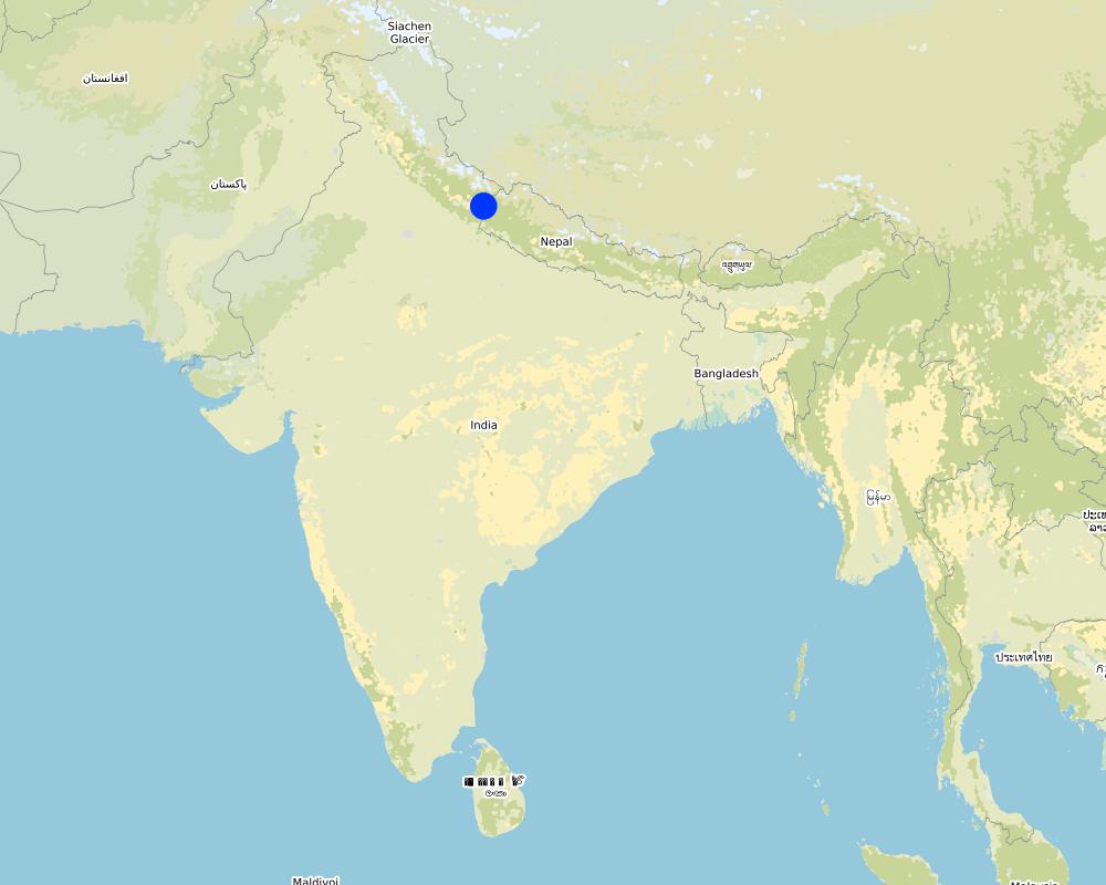
Map
×2.6 កាលបរិច្ឆេទនៃការអនុវត្ត
បង្ហាញឆ្នាំនៃការចុះអនុវត្ត:
2016
2.7 ការណែនាំពីបច្ចេកទេស
សូមបញ្ជាក់តើបច្ចេកទេសត្រូវបានណែនាំឱ្យអនុវត្តដោយរបៀបណា:
- តាមរយៈការបង្កើតថ្មីរបស់អ្នកប្រើប្រាស់ដី
- តាមរយៈគម្រោង / អន្តរាគមន៍ពីខាងក្រៅ
មតិយោបល់ (ប្រភេទនៃគម្រោង ។ល។):
Mr. Jagdamba Joshi's self-started initiative in his community can be attributed to his personal work experience. While serving in the army, he was trained to build ponds and trenches. Through his own observations and perception of these technologies, he was certain they would help support the depleting groundwater.
3. ចំណាត់ថ្នាក់នៃបច្ចេកទេស SLM
3.1 គោលបំណងចម្បង (១ ឬច្រើន) នៃបច្ចេកទេសនេះ
- កាត់បន្ថយ, បង្ការ, ស្តារឡើងវិញនូវការធ្លាក់ចុះគុណភាពដី
- អភិរក្សប្រព័ន្ធអេកូឡូស៊ី
- ការពារតំបន់ទីជម្រាល/តំបន់ខ្សែទឹកខាងក្រោមបញ្ចូលជាមួយបច្ចេកទេសផ្សេងទៀត
- កាត់បន្ថយហានិភ័យនៃគ្រោះមហន្តរាយ
- បន្ស៊ាំទៅនឹងការប្រែប្រួលអាកាសធាតុ/គ្រោះមហន្តរាយ និងផលប៉ះពាល់របស់វា
- បង្កើតផលប្រយោជន៍សង្គម
3.2 ប្រភេទដីប្រើប្រាស់មួយប្រភេទ (ច្រើនប្រភេទ) ដែលបានអនុវត្តបច្ចេកទេស
ដីប្រើប្រាស់ចម្រុះនៅលើដីតែមួយ:
បាទ/ចា៎

ដីព្រៃ/ដីដាំដើមឈើ
- ព្រៃ (ពាក់កណ្តាល) ធម្មជាតិ/ ដីព្រៃ
- ការដាំដើមឈើ ការដាំព្រៃឡើងវិញ
ព្រៃ (ពាក់កណ្តាល) ធម្មជាតិ / ដីព្រៃ៖ បញ្ជាក់ប្រភេទនៃការគ្រប់គ្រង:
- កាប់តែមួយចំនួន
ប្រភេទព្រៃ (ពាក់កណ្តាល) ធម្មជាតិ:
- សារពើរុក្ខជាតិនៃប្រព័ន្ធភ្នំធម្មជាតិតំបន់ពាក់កណ្តាលត្រូពិច
- Broadleaf/pine mixed forest
ការដាំដើមឈើ ការដាំដើមឈើឡើងវិញ៖ បញ្ជាក់ពីប្រភេទក្នុងតំបន់ និងប្រភេទលុប:
- ពូជបញ្ចូលគ្នា
ប្រភេទដើមឈើដែលដាំនៅកន្លែងដែលមិនធ្លាប់មានឈើពីមុន :
- ព្រៃស្ងួតដាំតំបន់ពាក់កណ្តាលត្រូពិច - ឈើស្លឹកធំ
- Quercus leucotrichophora, Quercus lanata, Quercus semecarpifolia, , Quercus glauca Thumb, Pyrus pasia, Myrica eaculanta and Rhododendron arborium
តើប្រភេទឈើខាងលើជាប្រភេទឈើក្នុងព្រៃល្បោះ ឬស្រោង?
- ព្រៃល្បោះ
ផលិតផល និងសេវាកម្ម:
- ឈើហ៊ុប
- អុស
- ការអភិរក្ស/ការការពារធម្មជាតិ
3.3 បន្ទាប់ពីអនុវត្តបច្ចេកទេស តើដីប្រើប្រាស់មានការប្រែប្រួលដែររឺទេ?
បន្ទាប់ពីអនុវត្តបច្ចេកទេស តើដីប្រើប្រាស់មានការប្រែប្រួលដែររឺទេ?
- ទេ (បន្តទៅសំណួរ 3.4)
3.4 ការផ្គត់ផ្គង់ទឹក
ការផ្គត់ផ្គង់ទឹកនៅកន្លែងអនុវត្តបច្ចេកទេស:
- ទឹកភ្លៀង
3.5 ក្រុម SLM ដែលបច្ចេកទេសស្ថិតនៅក្នុង
- ការស្តុកទុកទឹក
3.6 វិធានការ SLM ដែលបញ្ចូលនូវបច្ចេកទេស

វិធានការរចនាស័ម្ពន្ធ
- S4: កម្រិតភ្លឺ រណ្តៅ
- S5: ទំនប់ ថ្លុក ស្រះ
3.7 កំណត់ប្រភេទនៃការធ្លាក់ចុះគុណភាពដីសំខាន់ៗដែលបច្ចេកទេសនេះបានដោះស្រាយ

ការហូរច្រោះដីដោយសារទឹក
- Wt: ការបាត់ដីស្រទាប់លើដោយការហូរច្រោះ
- Wg: ការកកើតឡើងនូវកំទេចកំទីដីស្រទាប់ក្រោម
- Wm: ការបាក់ដី
- Wo: ផលប៉ះពាល់នៃការធ្លាក់ចុះគុណភាពកន្លែងឆ្ងាយ

ការបាត់បង់ទឹក
- Hs: ការប្រែប្រួលបរិមាណទឹកនៅលើផ្ទៃដី
- Hg: ការប្រែប្រួលបរិមាណទឹកនៅក្រោមដី
3.8 ការពារ កាត់បន្ថយ ឬស្តារឡើងវិញនៃការធ្លាក់ចុះគុណភាពដី
បញ្ជាក់ពីគោលដៅរបស់បច្ចេកទេស ដែលផ្តោតទៅការធ្លាក់ចុះគុណភាពដី:
- ការកាត់បន្ថយការធ្លាក់ចុះគុណភាពដី
- ការជួសជុល/ ស្តារឡើងវិញនៃឱនភាពដីធ្ងន់ធ្ងរ
4. បច្ចេកទេសជាក់លាក់ សកម្មភាពអនុវត្ត ធាតុចូល និងថ្លៃដើម
4.1 គំនូសបច្ចេកទេសនៃបច្ចេកទេសនេះ
លក្ខណៈពិសេសនៃបច្ចេកទេស (ទាក់ទងនឺងគំនូរបច្ចេកទេស):
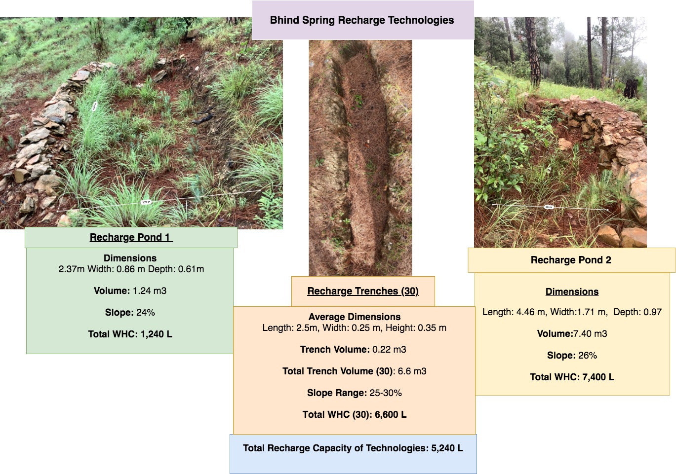
Bhind Catchment (Springshed) Recharge Technologies
Dimensions
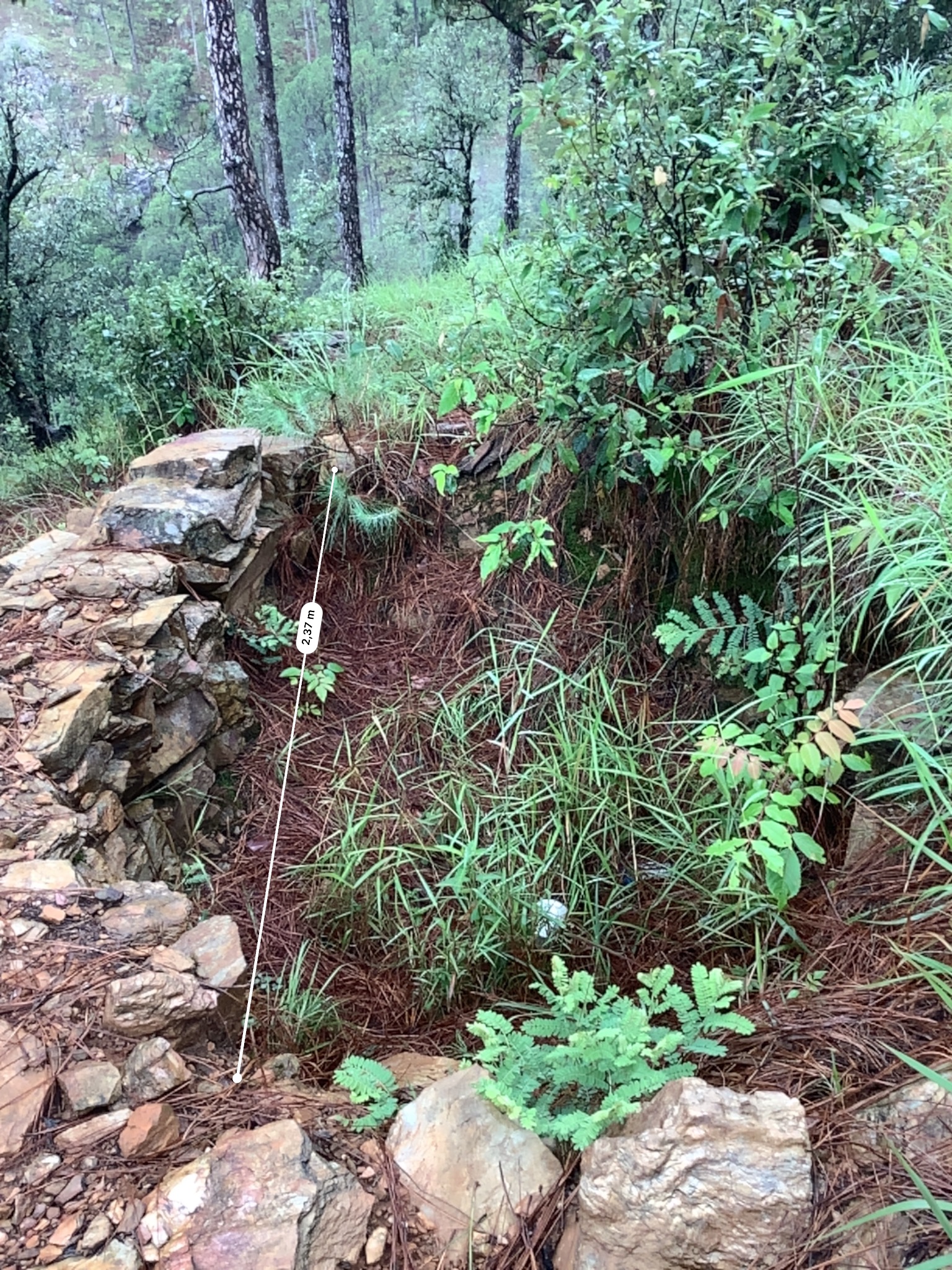
Recharge Pond 1- Length: 2.37m Width: 0.86 m Depth: 0.61m
Pond 1 Volume- 1.24 m3
Slope: 24%
Recharge Pond 2- Length: 4.46 m, Width: 1.71 m, Depth: 0.97
Pond 2 Volume- 7.40 m3
Slope: 26%
Recharge Trench- Length: 2.5m, Width: 0.25 m, Height: 0.35 m
Trench Volume: 0.22 m3
Total Trench Volume (30): 6.6 m3
Spacing: Trenches are in different locations of the Bhind springshed, 20 functional trenches are aggregated within 1m of each other in a broadleaf forest just north on the cucumber farm. 10 trenches are located directly above the Cucumber farm.
Slope Range: 25-30%
Water Holding Capacity (L):
Total Capacity of Recharge Pond 1: 1,240 L
Total Capacity of Recharge Pond 2: 7,400 L
Total Capacity of Trenches (30): 6,600 L
Total WHC of Technologies: 15,240 L
Total Catchment area of Bhind Springshed: ~10 Hectares
ឈ្មោះអ្នកនិពន្ធ:
Jaclyn Bandy
កាលបរិច្ឆេទ:
25/07/2019
លក្ខណៈពិសេសនៃបច្ចេកទេស (ទាក់ទងនឺងគំនូរបច្ចេកទេស):
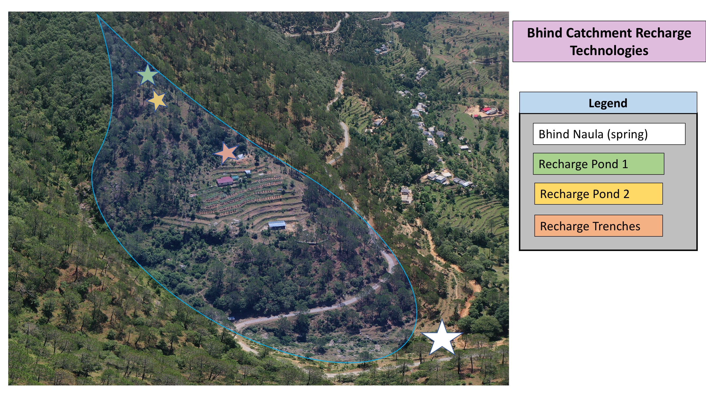
Bhind Catchment Recharge Technologies: Location Map
ឈ្មោះអ្នកនិពន្ធ:
Jaclyn Bandy
កាលបរិច្ឆេទ:
25/07/2019
លក្ខណៈពិសេសនៃបច្ចេកទេស (ទាក់ទងនឺងគំនូរបច្ចេកទេស):
Nakina Spring Catchments (springsheds) and Technology Locations
ឈ្មោះអ្នកនិពន្ធ:
Jaclyn Bandy
កាលបរិច្ឆេទ:
25/07/2019
លក្ខណៈពិសេសនៃបច្ចេកទេស (ទាក់ទងនឺងគំនូរបច្ចេកទេស):
Vaishnavi Recharge Structures Diagram Map
ឈ្មោះអ្នកនិពន្ធ:
Jaclyn Bandy
កាលបរិច្ឆេទ:
25/07/2019
លក្ខណៈពិសេសនៃបច្ចេកទេស (ទាក់ទងនឺងគំនូរបច្ចេកទេស):
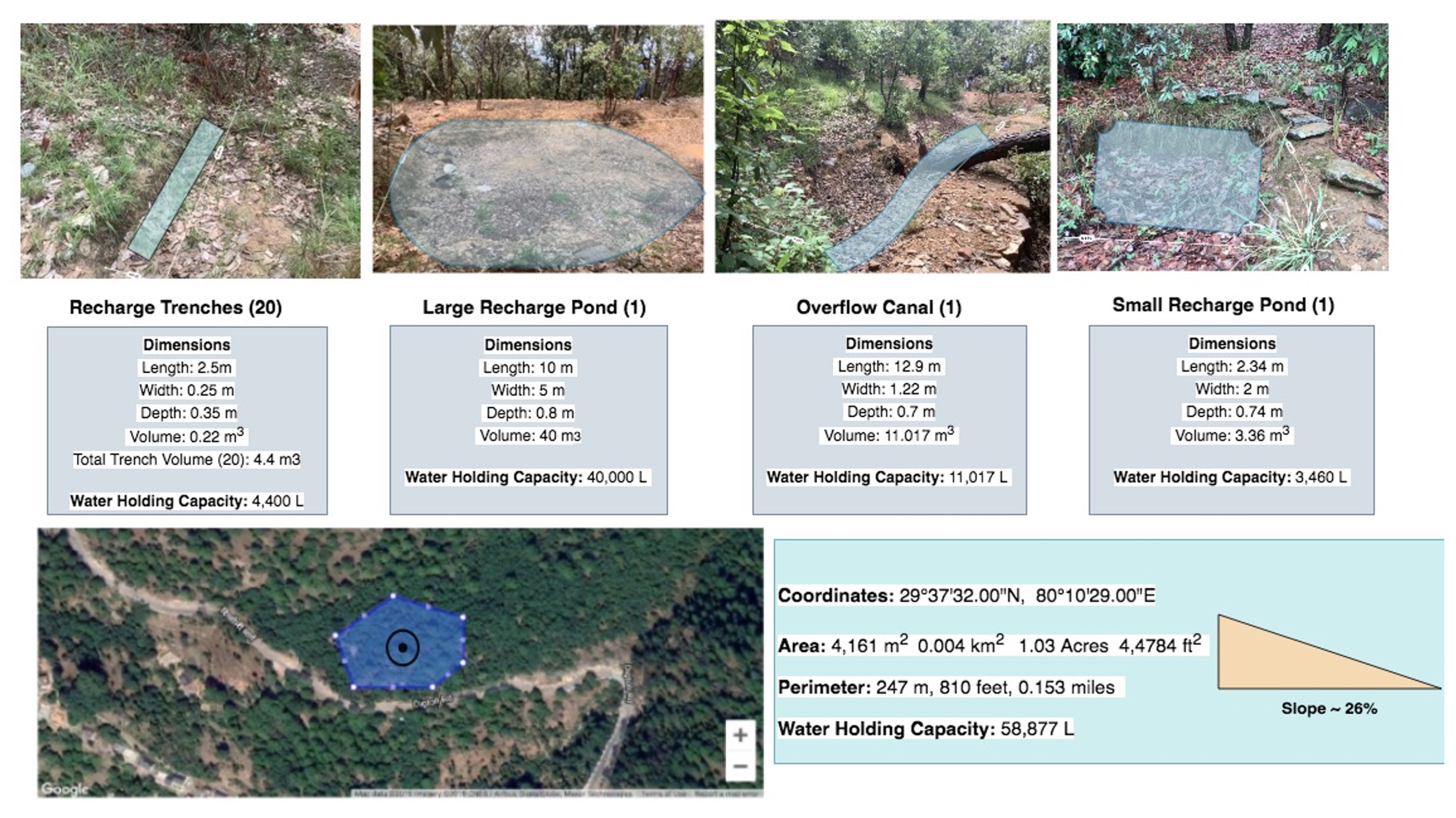
Technologies in Vaishinavi Springshed
Dimensions:
Large Recharge Pond- Length: 10m, Width: 5m, Depth: 0.8 m
Large Pond Volume: 40 cubic meters (m3)
Overflow Canal (narrow pond adjacent to large recharge pond)
Dimensions:
Overflow Canal- Length: 12.9 m, Width: 1.22 m, Depth: 0.7cm
Overflow Canal: 11.017 m3
Small Recharge Pond- Length: 2.34 m, Width: 2 m, Depth: 0.74 m
Small Pond Volume: 3.36 m3
Recharge Trench- Length: 2.5m, Width: 0.25 m, Height: 0.35 m
Trench Volume: 0.22 m3
Total Trench Volume (20): 4.4 m3
Spacing: trenches within 0.5m of each other and <1m spacing between trenches and broadleaf trees and other bushes
Slope: 26%
Water Holding Capacity (L):
Total Capacity of Large Pond: 40,000 L
Total Capacity of Overflow Canal: 11,017 L
Total Capacity of Small Pond: 3,460 L
Total Capacity of Trenches (20): 4,400 L
Total WHC of Technologies: 58,877 L
Total Area of Technologies: 0.5 Hectare
Total Area of Vaishnavi Catchment: ~13 Hectares
ឈ្មោះអ្នកនិពន្ធ:
Jaclyn Bandy
កាលបរិច្ឆេទ:
25/07/2019
4.2 ព័ត៌មានទូទៅដែលពាក់ព័ន្ធនឹងការគណនាធាតុចូល និងថ្លៃដើម
កំណត់របៀបនៃការគណនាថ្លៃដើម និងធាតុចូល:
- ក្នុងឯកតាបច្ចេកទេស
បញ្ជាក់ឯកតា:
2 Ponds, 1 Overflow Canal, 20 Recharge trenches
បញ្ជាក់ពីទំហំនៃឯកតា (បើពាក់ព័ន្ធ):
Total Trenches (20): 4.4 m3, Large Recharge Pond: 40 m3, Overflow Canal: 11.017 m3, Small Recharge Pond: 3.36 m3
ផ្សេងៗ/ រូបិយប័ណ្ណជាតិ (បញ្ជាក់):
INR
បើពាក់ព័ន្ធសូមកំណត់អត្រាប្តូរប្រាក់ពីដុល្លាទៅរូបិយប័ណ្ណតំបន់ (ឧ. 1 ដុល្លារ = 79.9 រៀលនៃរូបិយប័ណ្ណប្រេស៊ីល) ៖ 1 ដុល្លារ =:
70,0
កំណត់ថ្លៃឈ្នួលជាមធ្យមនៃការជួលកម្លាំងពលកម្មក្នុងមួយថ្ងៃ:
400 INR
4.3 សកម្មភាពបង្កើត
| សកម្មភាព | រយៈពេល (រដូវកាល) | |
|---|---|---|
| 1. | Plan designed by administrative committee of Van Panchayat | Winter 2016 |
| 2. | For technology construction, groups of men and women (8 total per group) were established with their planned working days | Pre-monsoon 2016 |
| 3. | Trenches and recharge ponds were dug on a rotation system by the groups on different days | Pre-monsoon 2016 |
| 4. | Compensation was given to participants upon completion of the project after 20 days work. | Pre-monsoon 2016 |
4.4 ថ្លៃដើម និងធាតុចូលដែលត្រូវការសម្រាប់ការបង្កើតបច្ចេកទេស
| បញ្ជាក់ពីធាតុចូល | ឯកតា | បរិមាណ | ថ្លៃដើមក្នុងមួយឯកតា | ថ្លៃធាតុចូលសរុប | % នៃថ្លៃដើមដែលចំណាយដោយអ្នកប្រើប្រាស់ដី | |
|---|---|---|---|---|---|---|
| កម្លាំងពលកម្ម | Community manual labor | person-days | 120,0 | 400,0 | 48000,0 | 100,0 |
| សម្ភារៈ | pick | pieces | 5,0 | 300,0 | 1500,0 | 100,0 |
| សម្ភារៈ | shovel | pieces | 5,0 | 500,0 | 2500,0 | 100,0 |
| សម្ភារៈ | pharuwa (hoe) | pieces | 4,0 | 300,0 | 1200,0 | 100,0 |
| សម្ភារៈ | khanti (digging bar) | pieces | 3,0 | 1500,0 | 4500,0 | 100,0 |
| សម្ភារៈ | hammer | pieces | 3,0 | 2000,0 | 6000,0 | 100,0 |
| សម្ភារៈ | small hammer | pieces | 3,0 | 300,0 | 900,0 | 100,0 |
| សម្ភារៈ | chino (chisel) | pieces | 4,0 | 500,0 | 2000,0 | 100,0 |
| សម្ភារៈសាងសង់ | Rocks excavated on site | |||||
| ថ្លៃដើមសរុបក្នុងការបង្កើតបច្ចេកទេស | 66600,0 | |||||
| ថ្លៃដើមសរុបក្នុងការបង្កើតបច្ចេកទេសគិតជាដុល្លារ | 951,43 | |||||
មតិយោបល់:
On average 4 people worked on establishing the technology/day = 400 x 4 = 1600 (labor cost/day)
1600 x 30 days = 48,000 Total Cost
4.5 សកម្មភាពថែទាំ
| សកម្មភាព | ពេលវេលា/ ភាពញឹកញាប់ | |
|---|---|---|
| 1. | Monitoring of the area for any damages or maintenance required | Weekly |
| 2. | Clearing of debris or filled sediment in pond/trenches/channel | Pre monsoon |
4.6 កំណត់ថ្លៃដើមសម្រាប់ការថែទាំ/ សកម្មភាពរបស់បច្ចេកទេស (ក្នុងរយៈពេលមួយឆ្នាំ)
| បញ្ជាក់ពីធាតុចូល | ឯកតា | បរិមាណ | ថ្លៃដើមក្នុងមួយឯកតា | ថ្លៃធាតុចូលសរុប | % នៃថ្លៃដើមដែលចំណាយដោយអ្នកប្រើប្រាស់ដី | |
|---|---|---|---|---|---|---|
| កម្លាំងពលកម្ម | Maintenance Labor | person-days | 4,0 | 1600,0 | 6400,0 | 100,0 |
| សម្ភារៈ | Communal equipment (see above for costs) | |||||
| ថ្លៃដើមសរុបសម្រាប់ការថែទាំដំណាំតាមបច្ចេកទេស | 6400,0 | |||||
| ថ្លៃដើមសរុបសម្រាប់ការថែទាំដំណាំតាមបច្ចេកទេសគិតជាដុល្លារ | 91,43 | |||||
4.7 កត្តាសំខាន់បំផុតដែលមានឥទ្ធិពលដល់ការចំណាយ
ពណ៌នាពីកត្តាប៉ះពាល់ចម្បងៗទៅលើថ្លៃដើម:
-Amount of siltation accumulated in the recharge structures (more debris/soil accumulation requires more maintenance and labor days)
-Labor availability
5. លក្ខណៈបរិស្ថានធម្មជាតិ និងមនុស្ស
5.1 អាកាសធាតុ
បរិមាណទឹកភ្លៀងប្រចាំឆ្នាំ
- < 250 មម
- 251-500 មម
- 501-750 មម
- 751-1,000 មម
- 1,001-1,500 មម
- 1,501-2,000 មម
- 2,001-3,000 មម
- 3,001-4,000 មម
- > 4,000 មម
កំណត់បរិមាណទឹកភ្លៀង (បើដឹង) ជា មីលីម៉ែត្រ:
1500,00
លក្ខណៈពិសេស/ មតិយោបល់លើរដូវភ្លៀង:
Monsoon- mid-June to mid-September; July and August are the rainiest months and the temperature is warm and moist; between 70-85% of the annual precipitation occurs in the monsoon season
Seasons
a. Winter or cold weather (mid Dec. - mid March)
b. Summer or hot weather (mid March - mid June)
c. Season of general rains (South - West monsoon season)
d. Season of retreating monsoon (mid September to mid November)
បញ្ជាក់ឈ្មោះឯកសារយោងនៃស្ថានីយឧតុនិយម:
India Meteorological Department, Meteorological Centre Dehradun
តំបន់កសិអាកាសធាតុ
- មានភ្លៀងមធ្យម
The overall climatic condition in the Pithoragarh district is governed by the southwest monsoon. It has a sub-tropical to temperate climate, with three pronounced seasons; summer, winter, and monsoon. The hilly terrain of the Himalayan region has snow cover and is cold during winter with snowfall normally occurring during the months of December to March.
Temperature- The temperature ranges from 0°C to 10°C in winter and from 8°C to 33°C in summer season. However, there is no meteorological observatory in the district. The account of the climate is based mainly on the records of the observations in the neighboring districts where similar meteorological conditions prevail. Variations in temperature are considerable from place to place and depend upon elevation as well as aspect. As the insolation is intense at high altitudes, in summer temperatures are considerably higher in the open than in the shade.
5.2 សណ្ឋានដី
ជម្រាលជាមធ្យម:
- រាបស្មើ (0-2%)
- ជម្រាលតិចតួច (3-5%)
- មធ្យម (6-10%)
- ជម្រាលខ្ពស់បន្តិច (11-15%)
- ទីទួល (16-30%)
- ទីទួលចោត (31-60%)
- ទីទួលចោតខ្លាំង (>60%)
ទម្រង់ដី:
- ខ្ពង់រាប
- កំពូលភ្នំ
- ជម្រាលភ្នំ
- ជម្រាលទួល
- ជម្រាលជើងភ្នំ
- បាតជ្រលងភ្នំ
តំបន់តាមរយៈកម្ពស់ :
- 0-100 ម
- 101-500 ម
- 501-1,000 ម
- 1,001-1,500 ម
- 1,501-2,000 ម
- 2,001-2,500 ម
- 2,501-3,000 ម
- 3,001-4,000 ម
- > 4,000 ម
បញ្ជាក់ថាតើបច្ចេកទេសនេះត្រូវបានអនុវត្តន៍នៅក្នុង:
- សណ្ឋានដីផត
មតិយោបល់ និងបញ្ចាក់បន្ថែមអំពីសណ្ឋានដី :
Average Altitude of evaluated sites: 1850m
Average Slope: 25%
5.3 ដី
ជម្រៅដីជាមធ្យម:
- រាក់ខ្លាំង (0-20 សម)
- រាក់ (21-50 សម)
- មធ្យម (51-80 សម)
- ជ្រៅ (81-120 សម)
- ជ្រៅខ្លាំង (> 120 សម)
វាយនភាពដី (ស្រទាប់លើ):
- គ្រើម/ មានពន្លឺ (ខ្សាច់)
- មធ្យម (ល្បាយ, ល្បាប់)
វាយនភាពដី (> 20 សម ស្រទាប់ក្នុង):
- មធ្យម (ល្បាយ, ល្បាប់)
សារធាតុសរីរាង្គនៅស្រទាប់ដីខាងលើ:
- មធ្យម (1-3%)
- ទាប (<1%)
បើអាចសូមភ្ជាប់ការពណ៌នាពីដីឱ្យបានច្បាស់ ឬព័ត៌មានដែលអាចទទួលបាន ឧ. ប្រភេទដី, pH ដី/ ជាតិអាស៊ីត, សមត្ថភាពផ្លាស់ប្តូរកាចុង, វត្តមាននីត្រូសែន, ភាពប្រៃ ។ល។:
Mountain/hill soils are a collective name given to various types of soils found under the following conditions :
-under sub-tropical, temperate and sub-alpine conditions
-under various forest types
Characteristics: very thin, fertile, and may be less than a centimeter deep on steep slopes; they are mixed with pebbles, shingles (a mass of small rounded pebbles), and gravels; they have a low-medium water holding capacity. Angular and subangular fragments of parent rock may be found mixed with the lower layers of the mountain and hill soils.
Texture: varies from loamy to sandy loam.
Soil Reaction: ranges from acidic to neutral (pH 4.6 to 6.5)
Organic Matter content: 1-5%
Ferrugenous red roils are found in this district and are well developed over Himalayan rocks (quartzite, biotite schist, amphibolite schist). They are free of carbonates and deficient in nitrogen, humus and phosphorus, light textured, porous, and friable (brittle/crumbly). The soil depth ranges from about 10cm-75 cm. These soils may be grouped into two on basis of morphology
1. Red earths- loose, friable topsoil rich in secondary concretions (hard, compact mass of matter formed by the precipitation of mineral cement within the spaces between particles, and is found in sedimentary rock or soil)
2. Red loam- argillaceous soils having a blocky structure (argillaceous minerals may appear silvery upon optical reflection and are minerals containing substantial amounts of clay-like components, e.g. argillaceous limestones are limestones consisting predominantly of calcium carbonate, but including 10-40% of clay minerals)
Brown soil: is found particularly under dense broadleaved temperate and sub-alpine forests. There occurs a thick layer of humus on the forest floor (made of decomposed leaves, branches, twigs) and the topsoil is extremely rich in humus
Podsolic Soil: soil that has developed in humid/temperate conditions usually under coniferous forests (e.g. deodar, blue pine, fir, spruce) over quartzite, granites, schists and gneiss.
(Citation: Kumaun: The Land and the People, Sharad Singh Negi (1993)
5.4 ទឹកដែលអាចទាញមកប្រើប្រាស់បាន និងគុណភាពទឹក
នីវ៉ូទឹកក្រោមដី:
5-50 ម
ទឹកលើដីដែលអាចទាញយកប្រើប្រាស់បាន:
កម្រិតមធ្យម
គុណភាពទឹក (មិនបានធ្វើប្រត្តិកម្ម):
ទឹកពិសារដែលមានគុណភាពល្អ
គុណភាពទឹក គឺផ្តោតទៅលើ៖:
ទឹកក្រោមដី
តើមានបញ្ហាភាពទឹកប្រៃហូរចូលមកដែរឬទេ?
ទេ
តើទឹកជំនន់កំពុងកើតមាននៅតំបន់នេះដែររឺទេ?
ទេ
មតិយោបល់ និងលក្ខណៈពិសេសផ្សេងៗទៀតលើគុណភាព និងបរិមាណទឹក :
Quantity: Water crisis has been a perennial problem in both the rural and urban areas of the Pithoragarh district
There is scarcity of safe drinking water of the villages in the study area. Hand pumps are often not functioning, pipe-water schemes are unreliable and the spring discharges have reduced during the dry season. Hand-pumped water often has a high iron content and bitter taste. Poor quality of groundwater in some of the naulas is mainly due to misuse and/or disuse of the structures.
A block-district groundwater resource estimation could not be carried out as the area is hilly (with slope >20%) and in major part aquifers are small, isolated bodies, and groundwater abstraction is done mainly through hand pumps and springs with small discharges.
However, we collected some physicochemical parameters that indicate the water (sourced from springs) is of good quality:
Water Quality Parameters of Springs:
pH: 6.29-8.18
Temp: 19.0-23.5 ºC
Electrical Conductivity: 109-504 µmsiemens
Total Dissolved Solids: 75-385 ppm
Other Parameters (from springs of nearby district, Champawat)
Electrical Conductivity: 127-222 µmsiemens
pH: 7.69-8.24
Calcium: 16-36 mg/l
Magnesium: 4.9-7.3 mg/l
Bicarbonate: 61-134 mg/l
Chloride: 5.3- 8.9 mg/l
Total Hardness as CaCO3: 70-110 mg/l
Source: Government of India Ministry of Water Resources, Central Ground Water Board, 2009 Groundwater Brochure of Champawat District (2009
5.5 ជីវៈចម្រុះ
ភាពសម្បូរបែបនៃប្រភេទ:
- កម្រិតមធ្យម
ភាពសម្បូរបែបនៃទីជម្រក:
- កម្រិតមធ្យម
មតិយោបល់ និងលក្ខណៈពិសេសផ្សេងទៀតលើជីវចម្រុះ:
Uttarakhand has more than 7000 species of medicinal plants and 500 species of fauna. Floral diversity contributes 31% of total floral density of India. Fauna contributes just 1.58% of the total faunal density of the country. There are 119 endemic species of flowering plants in the state that exhibited 2.35% endemism and 35 faunal endemic species. Because it lies at the juncture of India, Nepal and the Tibeten Autononmous region, there often cases of poaching and smuggling of wildlife contrabands, including bear bile, musk pods and leopard skins through the borders. Yarsa Gumba Ophiocordyceps sinensis, commonly known as Caterpillar Fungus, is also illegally traded transboundary in the region, together with various plant species. Due to anthropogenic impacts, changes is soil quality, and climatic elements, the biodiversity of our study site is not as high as in other areas of the Pithoragarh district.
Citation: Sundriyal, M. & Sharma, B. (2016). Status of Biodiversity in Central Himalaya, Applied Ecology and Environmental Sciences, 4( 2), 37-43.
5.6 លក្ខណៈនៃអ្នកប្រើប្រាស់ដីដែលអនុវត្តបច្ចេកទេស
នៅមួយកន្លែង ឬពនេចរ :
- នៅមួយកន្លែង
ទីផ្សារនៃប្រព័ន្ធផលិតកម្ម:
- សម្រាប់ហូបក្នុងគ្រួសារ (ផ្គត់ផ្គង់ខ្លួនឯង)
- ពាក់កណ្តាលពាណិជ្ជកម្ម (ផ្គត់ផ្គង់ខ្លួនឯង/ ពាណិជ្ជកម្ម)
ចំណូលក្រៅកសិកម្ម:
- 10-50% នៃចំណូល
កម្រិតជីវភាព:
- មិនល្អ
ឯកជន ឬក្រុម:
- ជាក្រុម/ សហគមន៍
កម្រិតប្រើប្រាស់គ្រឿងយន្ត:
- ប្រើកម្លាំងពលកម្ម
យេនឌ័រ:
- ស្ត្រី
- បុរស
អាយុរបស់អ្នកប្រើប្រាស់ដី:
- យុវវ័យ
- វ័យកណ្តាល
- មនុស្សចាស់
5.7 ទំហំផ្ទៃដីជាមធ្យមនៃដីប្រើប្រាស់ដោយអ្នកប្រើប្រាស់ដី ក្នុងការអនុវត្តបច្ចេកទេស
- < 0.5 ហិកតា
- 0.5-1 ហិកតា
- 1-2 ហិកតា
- 2-5 ហិកតា
- 5-15 ហិកតា
- 15-50 ហិកតា
- 50-100 ហិកតា
- 100-500 ហិកតា
- 500-1,000 ហិកតា
- 1,000-10,000 ហិកតា
- > 10,000 ហិកតា
តើផ្ទៃដីនេះចាត់ទុកជាទំហំកម្រិតណាដែរ ខ្នាតតូច មធ្យម ឬខ្នាតធំ (ធៀបនឹងបរិបទតំបន់)?
- ខ្នាតតូច
5.8 ភាពជាម្ចាស់ដី កម្មសិទ្ធប្រើប្រាស់ដី និងកម្មសិទ្ធប្រើប្រាស់ទឹក
ភាពជាម្ចាស់ដី:
- ភូមិ
កម្មសិទ្ធិប្រើប្រាស់ដី:
- ជាក្រុម (មានដែនកំណត់)
កម្មសិទ្ធប្រើប្រាស់ទឹក:
- អាស្រ័យផលសេរី (មិនមានការកំណត់)
- ជាក្រុម (មានដែនកំណត់)
តើកម្មសិទ្ធប្រើប្រាស់ដី គឺផ្អែកលើប្រព័ន្ធច្បាប់បែបបុរាណ?
បាទ/ចា៎
សូមបញ្ជាក់:
Under the Kumaun Panchayat forest rules of 1931 (amended in 1976): the Van Panchayat (community forest council) is formed out of non-private land within the settlement boundaries of a village. Accordingly, all villagers are members of the VP upon their approval by a Sub-Divisional Magistrate under the state Revenue Department. The members are collectively referred to as the general body, which selects the management committee members through a democratic process.
មតិយោបល់:
5-9 elected members assume control of the forest and the extent of villager use. They additionally raise funds and mobilize the village to protect and support sustainable land use. Presently 12,089 Van Panchayats are entrusted with the management of over 5,449.64 km2 of forests.
5.9 ការប្រើប្រាស់សេវាកម្ម និងហេដ្ឋារចនាសម្ព័ន្ធ
សុខភាព:
- មិនល្អ
- មធ្យម
- ល្អ
ការអប់រំ:
- មិនល្អ
- មធ្យម
- ល្អ
ជំនួយបច្ចេកទេស:
- មិនល្អ
- មធ្យម
- ល្អ
ការងារ (ឧ. ការងារក្រៅកសិដ្ឋាន):
- មិនល្អ
- មធ្យម
- ល្អ
ទីផ្សារ:
- មិនល្អ
- មធ្យម
- ល្អ
ថាមពល:
- មិនល្អ
- មធ្យម
- ល្អ
ផ្លូវ និងការដឹកជញ្ជូន:
- មិនល្អ
- មធ្យម
- ល្អ
ទឹកផឹក និងអនាម័យ:
- មិនល្អ
- មធ្យម
- ល្អ
សេវាកម្មហិរញ្ញវត្ថុ:
- មិនល្អ
- មធ្យម
- ល្អ
មតិយោបល់:
The situation of infrastructure is difficult and inconsistent in the hill regions because of the terrain. The major infrastructural issues are drinking water and irrigation facilities, electricity, transportation and communication facilities and social infrastructure (housing and education). As for financial services, only the State Bank of India (SBI) is active in the hill regions where it is trying to achieve the objective of 100% financial inclusion. Some villages mentioned buying into into agricultural insurance in the past, however this was a temporary enterprise and they were never compensated after extreme climatic events that occurred and damaged over 70% of their crop.
Though infrastructure and education has generally improved over the years, institutional and marketing networks in the region aimed at supporting hill-farmers are lacking.
6. ផលប៉ះពាល់ និងការសន្និដ្ឋាន
6.1 ផលប៉ះពាល់ក្នុងបរិវេណអនុវត្តបច្ចេកទេសដែលកើតមាន
ផលប៉ះពាល់លើសេដ្ឋកិច្ចសង្គម
ផលិតផល
ផលិតកម្មចំណីសត្វ
គុណភាពចំណីសត្វ
គុណភាពព្រៃឈើ/ដីព្រៃ
ការគ្រប់គ្រងដី
មតិយោបល់/ ការបញ្ជាក់:
Constructing these technologies in the forest and within spring catchment areas has supported the village to work collaboratively and increased overall insightfulness to on-and-offsite effects and potentials of SLM.
ចំណូល និងថ្លៃដើម
ការចំណាយលើធាតុចូលកសិកម្ម
មតិយោបល់/ ការបញ្ជាក់:
Decreased the amount of supplementary fodder required for livestock. The amount of grasses, fodder, and fuelwood has increased with the help of strategic placement of recharge ponds and trenches.
បន្ទុកការងារ
មតិយោបល់/ ការបញ្ជាក់:
Less time spent collecting forest resources, as the area where the technology is near the village and supports fodder/fuelwood growth (broadleaf forest/oak nursery area)
ផលប៉ះពាល់ទៅលើវប្បធម៌សង្គម
សន្តិសុខស្បៀង/ ភាពគ្រប់គ្រាន់ខ្លួនឯង
មតិយោបល់/ ការបញ្ជាក់:
Improved self sufficiency of village, as the technology has helped increase their water availability.
ស្ថានភាពសុខភាព
មតិយោបល់/ ការបញ្ជាក់:
Water condition has improved. Their is less time spent collecting fodder in the forest, as these technologies have supported fodder tree and grass production.
កម្មសិទ្ធដីប្រើប្រាស់/ ទឹក
មតិយោបល់/ ការបញ្ជាក់:
There is less friction between the villages of Bhurimuni and Nakina. Nakina did not have to go ask for permission to access the Bhurimuni Naula for water during the dry season.
ឱកាសវប្បធម៍
មតិយោបល់/ ការបញ្ជាក់:
The improvements of forest resource security and resilience to disasters/climatic extremes have allowed the villagers to spend more of their time building up a communal gathering area for ceremonial events and festivals around the Vaishnavi Temple.
ឱកាសនៃការបង្កើតថ្មី
មតិយោបល់/ ការបញ្ជាក់:
There is more time for the women (1-2 hours saved) as the structural technologies have supported existing vegetation growth. This has reduced the time and distance required for gathering fodder an fuelwood.
ស្ថាប័នសហគមន៍
មតិយោបល់/ ការបញ្ជាក់:
The partnerships formed between land-users, the Nakina Van Panchayat, the Forest Department and external institutions are leading examples of necessary cooperation between all levels of governance for project harmonization.
ចំណេះដឹង SLM / ការធ្លាក់ចុះគុណភាពដី
មតិយោបល់/ ការបញ្ជាក់:
People are taking forest management seriously and making innovative plans for further SLM interventions, whether it be community-initiated or with the help of external institutions/agencies.
ការកាត់បន្ថយជម្លោះ
មតិយោបល់/ ការបញ្ជាក់:
Increased availability of resources has helped the overall morale of the village. This has further enhanced cooperation for interventions that require participation and effort in the community forest.
ស្ថានភាពក្រុមដែលមានបញ្ហាក្នុងសង្គម និងសេដ្ឋកិច្ច
ផលប៉ះពាល់ទៅលើអេកូឡូស៊ី
វដ្តទឹក/លំហូរ
បរិមាណទឹក
មតិយោបល់/ ការបញ្ជាក់:
The technologies act as a water reservoir and improve water holding capacity of the soil by decreasing runoff velocity.
ការប្រមូលស្តុកទុកទឹក
លំហូរទឹកលើផ្ទៃដី
ប្រព័ន្ធបង្ហូរទឹក
នីវ៉ូទឹកក្រោមដី/ ដង្ហើមទឹក
រំហួត
ដី
សំណើមដី
គម្របដី
ការបាត់បង់ដី
ការកើនឡើងដី
ដីប្រេះ
ដីហាប់
សារធាតុសរីរាង្គដី/ការបូនក្រោមដី
មតិយោបល់/ ការបញ្ជាក់:
Micro-catchments accumulate debris/silt washed down from upstream areas. When managed properly, this can function as a beneficial mulch to the soil, improving bioavailabiltiy of nutrients for plants.
ជីវចម្រុះ៖ ដំណាំ, សត្វ
ដំណាំគម្រប
មតិយោបល់/ ការបញ្ជាក់:
Improved water availability and thus potential/support for vegetation growth and cover.
ជីវម៉ាស/ កាបូនលើដី
មតិយោបល់/ ការបញ្ជាក់:
Improves grasses and vegetation growth, and collects debris/silt from upstream areas.
ភាពសម្បូរបែបនៃរុក្ខជាតិ
មតិយោបល់/ ការបញ្ជាក់:
Micro-catchments provide water for native grasses, vegetation, and can help with the germination of seeds.
ភាពសម្បូរបែបនៃសត្វ
មតិយោបល់/ ការបញ្ជាក់:
Micro-catchments provide water and habitat for small animals/birds.
ប្រភេទសត្វមានប្រយោជន៍
មតិយោបល់/ ការបញ្ជាក់:
Micro-catchments provide water, habitat, and protection for microorganisms and insect species. They support native grasses and vegetation.
ភាពសម្បូរបែបនៃទីជំរក
ការកាត់បន្ថយហានិភ័យនៃគ្រោះមហន្តរាយ និងគ្រោះអាកាសធាតុ
ដីបាក់/ លំហូរកំទិចកំទី
មតិយោបល់/ ការបញ្ជាក់:
Decreased surface flow velocity
ផលប៉ះពាល់នៃគ្រោះរាំងស្ងួត
មតិយោបល់/ ការបញ្ជាក់:
Improved groundwater availability and enhanced spring recharge
ផលប៉ះពាល់នៃព្យុះស៊ីក្លូន/ព្យុះភ្លៀង
មតិយោបល់/ ការបញ្ជាក់:
Erosion impacts from extreme rain storms is reduced by decreasing flow velocity
ហានិភ័យនៃភ្លើងឆេះព្រៃ
មតិយោបល់/ ការបញ្ជាក់:
Area is protected and forest is further enhanced by improved groundwater availability
អាកាសធាតុ
មតិយោបល់/ ការបញ្ជាក់:
Decreased surface temperature due to improved vegetation/biomass, soil cover and water availability.
6.2 ផលប៉ះពាល់ក្រៅបរិវេណអនុវត្តបច្ចេកទេសដែលកើតមាន
ទឹកដែលអាចទាញមកប្រើប្រាស់បាន
មតិយោបល់/ ការបញ្ជាក់:
Improved spring discharge in the peak dry season
លំហូរទឹកដែលអាចប្រើប្រាស់បាននៅរដូវប្រាំង
មតិយោបល់/ ការបញ្ជាក់:
Bhind and Vaishnavi Naulas (springs) have improved discharge in the peak dry season. According to villagers, there was little to no water available in May/June, and since 10 years the flow has returned due to improved forest management in combination with these structural technologies.
ទឹកជំនន់ខ្សែទឹកខាងក្រោម
មតិយោបល់/ ការបញ្ជាក់:
impact of flash flood is minimized
កំណកល្បាប់ខ្សែទឹកខាងក្រោម
មតិយោបល់/ ការបញ្ជាក់:
Helped slow down sediment and runoff
ទឹកក្រោមដី/ ការបំពុលទឹកទន្លេ
មតិយោបល់/ ការបញ្ជាក់:
No direct evidence, but statements from the locals indicate that there are less sediments in the spring water ( due to improved soil infiltration and buffering capacity)
Buffering/សមត្ថភាពចម្រោះ
ខូចខាតដល់ស្រែអ្នកជិតខាង
មតិយោបល់/ ការបញ្ជាក់:
Less damage from runoff
ខូចខាតដល់ហេដ្ឋារចនាសម្ព័ន្ធសាធារណៈ/ឯកជន
មតិយោបល់/ ការបញ្ជាក់:
Decreased intensity of runoff on the roadside and settlement below
6.3 ភាពប្រឈម និងភាពរួសនៃបច្ចេកទេសទៅនឹងការប្រែប្រួលអាកាសធាតុ និងគ្រោះអាកាសធាតុ/ គ្រោះមហន្តរាយ (ដែលដឹងដោយអ្នកប្រើប្រាស់ដី)
ការប្រែប្រួលអាកាសធាតុ
ការប្រែប្រួលអាកាសធាតុ
| រដូវកាល | កើនឡើង ឬថយចុះ | លក្ខណៈឆ្លើយតបនៃបច្ចេកទេសទៅនឹងការប្រែប្រួលអាកាសធាតុ | |
|---|---|---|---|
| សីតុណ្ហភាពប្រចាំឆ្នាំ | កើនឡើង | ល្អ | |
| បរិមាណទឹកភ្លៀងប្រចាំឆ្នាំ | ថយចុះ | មធ្យម | |
| ការប្រែប្រួលអាកាសធាតុផ្សេងៗ | Intensity of rainfall in wet season | កើនឡើង | ល្អ |
គ្រោះអាកាសធាតុ (មហន្តរាយ)
គ្រោះមហន្តរាយធម្មជាតិ
| លក្ខណៈឆ្លើយតបនៃបច្ចេកទេសទៅនឹងការប្រែប្រួលអាកាសធាតុ | |
|---|---|
| ព្យុះភ្លៀងតាមតំបន់ | ល្អណាស់ |
| ព្យុះរន្ទះតាមតំបន់ | ល្អ |
| ព្យុះទឹកកកតាមតំបន់ | ល្អ |
| ព្យុះព្រិលតាមតំបន់ | មិនស្គាល់ |
| ព្យុះកំបុតត្បូងតាមតំបន់ | ល្អ |
គ្រោះមហន្តរាយអាកាសធាតុ
| លក្ខណៈឆ្លើយតបនៃបច្ចេកទេសទៅនឹងការប្រែប្រួលអាកាសធាតុ | |
|---|---|
| រលកកម្តៅ | ល្អ |
| រាំងស្ងួត | ល្អ |
| ភ្លើងឆេះព្រៃ | ល្អ |
គ្រោះមហន្តរាយទឹក
| លក្ខណៈឆ្លើយតបនៃបច្ចេកទេសទៅនឹងការប្រែប្រួលអាកាសធាតុ | |
|---|---|
| ទឹកជំនន់ដោយទឹកភ្លៀង | មធ្យម |
| ដីបាក់ | មធ្យម |
មតិយោបល់:
The functionality of the technology depends on its maintenance. For example, after an extreme hydrological event such as a rainstorm, the trenches and ponds can fill up with sediment and debris. If the structures are not maintained and reconstructed after such damaging events, they lose their purpose.
Similarly, if there is no rain and extreme drought, the structure may be intact with no maintenance. However with no water to collect, the technology has little use.
6.4 ការវិភាគថ្លៃដើម និងអត្ថប្រយោជន៍
តើផលចំណេញ និងថ្លៃដើមត្រូវបានប្រៀបធៀបគ្នាយ៉ាងដូចម្តេច (ទស្សនៈរបស់អ្នកប្រើប្រាស់ដី)?
រយៈពេលខ្លី:
ប៉ះពាល់តិចតួចបំផុត
រយៈពេលវែង:
វិជ្ជមានខ្លាំង
តើផលចំណេញ និងការថែទាំ/ ជួសជុលត្រូវបានប្រៀបធៀបគ្នាយ៉ាងដូចម្តេច (ទស្សនៈរបស់អ្នកប្រើប្រាស់ដី)?
រយៈពេលខ្លី:
ប៉ះពាល់តិចតួចបំផុត
រយៈពេលវែង:
វិជ្ជមានខ្លាំង
មតិយោបល់:
Due to these interventions, spring discharge has improved in the dry season. As villagers are highly reliant on these springs, this has had a huge impact on the community. Establishment and maintenance costs are extremely low compared to the benefits.
6.5 ការទទួលយកបច្ចេកទេស
- 11-50%
បើអាច សូមបញ្ជាក់ពីបរិមាណ (ចំនួនគ្រួសារ និង/ ឬតំបន់គ្របដណ្តប់):
In combination with the efforts of the Uttarakhand Forrest Department, under the Tata Water Mission (an initiative of Tata Trusts) 312 villages (out of 1,724) in Pithoragarh district have successfully implemented springshed management projects. They adopted a catchment area approach by identifying sources of springs, understanding their history and reason for decreased discharge before identifying areas that need to be rejuvenated.
ក្នុងចំណោមគ្រួសារទាំងអស់ដែលបានអនុវត្តបច្ចេកទេស តើមានប៉ុន្មានគ្រួសារដែលចង់ធ្វើដោយខ្លួនឯង ដោយមិនទទួលបានសម្ភារៈលើកទឹកចិត្ត/ប្រាក់ឧបត្ថម្ភ?:
- 0-10%
មតិយោបល់:
Land users received an incentive of 5.30 USD (400INR), which is provided by funds that lie in the joint account between the Van Panchayat and the Uttarakhand State Forest Department. The community has limited access to these funds, and consent is needed to withdraw money for community forest related activities. Due to the time and drudgery to establish the technologies in the appropriate zone (usually far from the village, in the upper catchment area), many villagers will not willingly go out digging trenches and recharge ponds in the forest without incentives or exemplary evidence that these structures will give tangible or immediate benefits.
6.6 ការបន្សុំា
តើថ្មីៗនេះ បច្ចេកទេសនេះត្រូវបានកែតម្រូវដើម្បីបន្ស៊ាំទៅនឹងស្ថានភាពប្រែប្រួលដែរឬទេ?
បាទ/ចា៎
បើឆ្លើយបាទ/ ចា៎ សូមកំណត់ថាតើស្ថានភាពប្រែប្រួលមួយណាត្រូវបានបន្ស៊ាំ:
- ការប្រែប្រួលអាកាសធាតុ/គ្រោះមហន្តរាយធម្មជាតិ
បញ្ជាក់ពីការបន្ស៊ាំនៃបច្ចេកទេស (ការរៀបចំ, ឧបករណ៍/ប្រភេទ ។ល។):
Water channels were made to direct runoff into the large recharge pond.
6.7 ភាពខ្លាំង/ គុណសម្បត្តិ/ ឱកាសនៃបច្ចេកទេស
| ភាពខ្លាំង/ គុណសម្បត្តិ/ ឱកាសនៅកន្លែងរបស់អ្នកប្រើប្រាស់ដី |
|---|
| Reduces erosion, improves catchment of runoff, increases groundwater availability and aids in spring recharge. |
| Supports soil quality and broadleaf forest growth through increased infiltration, improved soil moisture and water availability. |
| Reduces impact of landslides and further downstream damage to settlements (water erosion, siltation) |
| ភាពខ្លាំង/ គុណសម្បត្តិ/ ឱកាស ទស្សនៈរបស់បុគ្គលសំខាន់ៗ |
|---|
| Views aligned with land user |
6.8 ភាពខ្សោយ/ គុណវិបត្តិ/ ហានិភ័យនៃបច្ចេកទេស និងវិធីសាស្ត្រដោះស្រាយ
| ភាពខ្សោយ/ គុណវិបត្តិ/ ហានិភ័យ ទស្សនៈរបស់អ្នកប្រើប្រាស់ដី | តើបច្ចេកទេសទាំងនោះបានដោះស្រាយបញ្ហាដូចម្តេច? |
|---|---|
| Structural damage of technologies due to extreme hydrological events | Maintenance after such events and application of vegetative measures to complement. Combine with conservation practices like mulching to aid infiltration and deceleration of runoff speed. |
| Function of technologies are lost when there is no rainfall | In general, biological interventions are necessary to aid groundwater recharge in the area. However, due to increased vegetation cover, soil moisture and available organic matter can be conserved in times of drought. |
| ភាពខ្សោយ/ គុណវិបត្តិ/ ហានិភ័យ ទស្សនៈរបស់អ្នកចងក្រងឬបុគ្គលសំខាន់ៗ | តើបច្ចេកទេសទាំងនោះបានដោះស្រាយបញ្ហាដូចម្តេច? |
|---|---|
| Function of the technologies can be compromised with inappropriate design, site selection, or quantification of the area necessary for significant groundwater recharge (e.g. amount of recharge pond and trenches). | Training and awareness about the limitations of this technology should be known and made aware by supporting agencies. Selection of catchment areas for springsheds and catchment calculations need to be assessed. Additionally, onsite experts should be provided during implementation. |
7. ឯកសារយោង និងវេបសាយ
7.1 វិធីសាស្ត្រ/ ប្រភពនៃព័ត៌មាន
- តាមការចុះទីវាល ការស្រាវជ្រាវនៅទីវាល
Villages: Naikina, Digtoli, Bhurmuni, Talli Seam, Malli Seam
- ការសម្ភាសន៍ជាមួយអ្នកប្រើប្រាស់ដី
1.Gram Panchayat (Head of Forest Council)
2. Former Village Head
3. Community group discussions (FDGs)
- ការសម្ភាសន៍ជាមួយអ្នកជំនាញ/ ឯកទេស
1. Uttarakhand Forest Department
2. Local NGO Himalayan Sewa Samiti, CHEA
3. G.B. Pant researchers and project implementers
- ការចងក្រងពីរបាកការណ៍ និងឯកសារផ្សេងៗទៀតដែលមាន
តើពេលណាដែលទិន្នន័យបានចងក្រង (នៅទីវាល)?
04/07/2019
មតិយោបល់:
Field data duration: June 2019-July 2019
7.3 ការភ្ជាប់ទៅកាន់ព័ត៌មានពាក់ព័ន្ធលើប្រព័ន្ធអនឡាញ
ចំណងជើង/ ពណ៌នា:
Dhara Vikas Handbook: A User Manual for Springshed Development to Revive Himalayan Springs
វេបសាយ:
https://www.indiawaterportal.org/news/dhara-vikas-handbook-user-manual-springshed-development-revive-himalayan-springs
ចំណងជើង/ ពណ៌នា:
Protocol for Reviving Springs in the Hindu Kush Himalaya: A Practitioner’s Manual
វេបសាយ:
http://lib.icimod.org/record/34040/files/SpringManual04-2018.pdf
ចំណងជើង/ ពណ៌នា:
Reviving Dying Springs: Climate Change Adaptation Experiments From the Sikkim Himalaya
វេបសាយ:
https://www.researchgate.net/publication/273670290_Reviving_Dying_Springs_Climate_Change_Adaptation_Experiments_From_the_Sikkim_Himalaya
ចំណងជើង/ ពណ៌នា:
Assessing Landscape Restoration Opportunities for Uttarakhand, June 2018
វេបសាយ:
https://www.iucn.org/sites/dev/files/content/documents/uttarakhand_restoration_opportunities_assessment_report_june_20181.pdf
ចំណងជើង/ ពណ៌នា:
Stories of Success- narratives from a sacred land
វេបសាយ:
http://lib.icimod.org/record/32844/files/SuccessStory.pdf
ការតភ្ជាប់ និងម៉ូឌុល
ពង្រីកមើលទាំងអស់ បង្រួមទាំងអស់ការតភ្ជាប់
Community Forest Management in the Nakina Van Panchayat [ប្រទេសឥណ្ឌា]
Van Panchayats or village forest councils are a impressive example of grassroots community management of natural resources, where a specific administrative unit is locally elected by community members who are responsible for the management of activities related to the forest.
- អ្នកចងក្រង៖ Jaclyn Bandy
Naula Management and Conservation [ប្រទេសឥណ្ឌា]
Naulas are shallow, four-sided stepped wells designed to collect water from subterranean seepages or springs and are used to meet domestic water needs by the local communities. Naula management and conservation encompasses a range of activities that preserve their structure and function.
- អ្នកចងក្រង៖ Jaclyn Bandy
ម៉ូឌុល
គ្មានម៉ូឌុល