Check dams from stem cuttings [Nicarágua]
- Criação:
- Atualização:
- Compilador/a: Mathias Gurtner
- Editor: –
- Revisores: Deborah Niggli, Alexandra Gavilano
Diques de postes prendedizos (Spanish)
technologies_1719 - Nicarágua
Veja as seções
Expandir tudo Recolher tudo1. Informação geral
1.2 Detalhes do contato das pessoas capacitadas e instituições envolvidas na avaliação e documentação da tecnologia
Especialista em GST:
Rodriguez Roger
PASOLAC
Nicarágua
Especialista em GST:
Mongalo Reinerio
Sociación Tierra y Vida (AT&V)
Nicarágua
Nome do projeto que facilitou a documentação/avaliação da Tecnologia (se relevante)
Book project: where the land is greener - Case Studies and Analysis of Soil and Water Conservation Initiatives Worldwide (where the land is greener)1.3 Condições em relação ao uso da informação documentada através de WOCAT
O/a compilador/a e a(s) pessoa(s) capacitada(s) aceitam as condições relativas ao uso de dados documentados através da WOCAT:
Sim
1.4 Declaração de sustentabilidade da tecnologia descrita
A tecnologia descrita aqui é problemática em relação a degradação da terra de forma que não pode ser declarada uma tecnologia de gestão sustentável de terra?
Não
2. Descrição da tecnologia de GST
2.1 Descrição curta da tecnologia
Definição da tecnologia:
Gully rehabilitation by check dams made of stem cuttings from trees. These living barriers retard concentrated runoff and fill up the gullies gradually with sediment.
2.2 Descrição detalhada da tecnologia
Descrição:
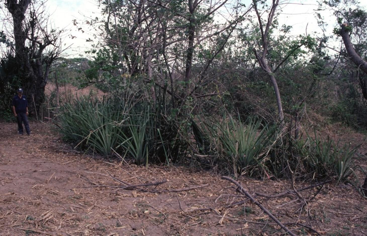
Stem cuttings from specific tree species have the ability to strike roots and continue growing after being planted into the earth. In this case study local species have been used to create check dams in gullies: these include jinocuebo (Simaroubaceaes bombacaceaes, and also jobo, tiguilote, pochote from the same family). Other suitable species are jocote (Spondias purpurea) and madero negro (Gliricidia sepium). As an option the pinapple-like piñuela (Bromelia pinguin) can be planted in association with the stem cuttings to further reinforce the system. Tree stems are cut into pieces 5-15 cm thick and 1.5-2.5 m long, depending on the depth of the gully. The cuttings are planted to half of their length, and formed into semi-circular barriers (see diagram). The dams retard runoff and thus retain eroded sediment. Spacing between dams depends on the gradient of the gully bed. For example on a 15% slope it is recommended to build a dam every 4 meters (see spacing under establishment activities). Between dams, the gully gradually fills up with eroded soil, the speed of the runoff is further reduced and agricultural land that has been divided by the gully is reconnected. Large and deep gullies may change over time into a sequence of narrow fertile terraces where crops can be grown.
However, the check dams should be seen as part of an integrated catchment management and protection plan, and thus be supported by other SWC measures on the lateral slopes, such as retention ditches and/or live barriers laid out along the contour. Erosion and runoff control on the sides of each gully is an essential part of the rehabilitation process. These check dams of rooted poles are more robust and durable than stone dams in soils of sandy/ loamy texture. On moderate and steep slopes a combination of stem cutting and stone dams is recommended.
After two to three years the barriers should be pruned - yielding wood and fodder. Dead poles should be replaced and the dam widened if necessary.
In this case study the dams are constructed in a semi-arid region with erratic rainfall where gullies are common on agricultural land, be it cropland or grazing land. The land users are mainly peasant farmers, growing crops for subsistence on smallholdings, and living in very poor conditions. This system of gully rehabilitation is promoted by an NGO entitled ‘Asociación Tierra y Vida’ through farmerto-farmer (campesino a campesino) extension.
2.3 Fotos da tecnologia
Galeria de Mídias
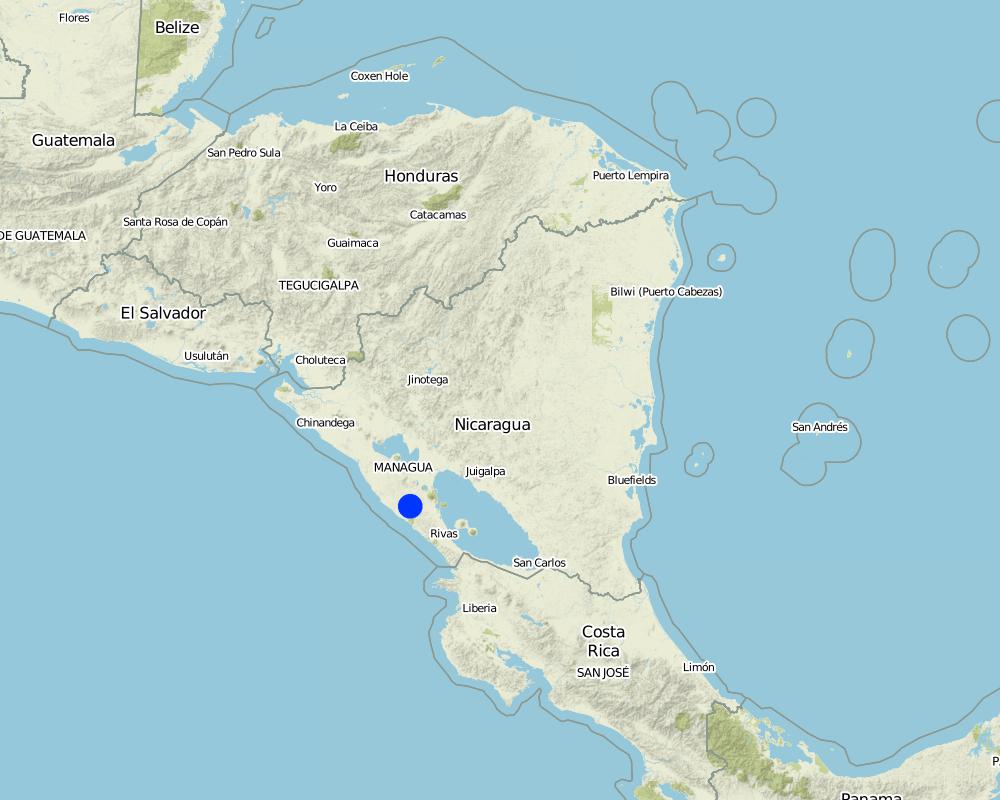
2.5 País/região/locais onde a tecnologia foi aplicada e que estão cobertos nesta avaliação
País:
Nicarágua
Região/Estado/Província:
Santa Teresa, Paso de la Solera
Especificação adicional de localização:
Carazo, Nicaragua
Comentários:
Total area covered by the SLM Technology is 5 km2.
Map
×2.6 Data da implementação
Caso o ano exato seja desconhecido, indique a data aproximada:
- menos de 10 anos atrás (recentemente)
2.7 Introdução da tecnologia
Especifique como a tecnologia foi introduzida:
- através de projetos/intervenções externas
3. Classificação da tecnologia de GST
3.1 Principal/principais finalidade(s) da tecnologia
- Reduz, previne, recupera a degradação do solo
- Reduzir riscos de desastre
3.2 Tipo(s) atualizado(s) de uso da terra onde a tecnologia foi aplicada

Terra de cultivo
- Cultura anual
Especifique:
Longest growing period in days: 100, Longest growing period from month to month: May to August; Second longest growing period in days: 90, Second longest growing period from month to month: September to November

Pastagem
Comentários:
Major land use problems (compiler’s opinion): There is a range of factors that limit agricultural production in the area: soil degradation, extensive gully formation on crop land, low soil fertility, lack of inputs for crop production, erratic precipitation. Also, lack of interest/knowledge and lack of resources hinder the implementation of SWC measures.
3.4 Abastecimento de água
Abastecimento de água para a terra na qual a tecnologia é aplicada:
- Precipitação natural
3.5 Grupo de GST ao qual pertence a tecnologia
- Medidas de curva de nível
3.6 Medidas de GST contendo a tecnologia

Medidas vegetativas
- V5: Outros

Medidas estruturais
- S4: Valas de nível, fossos
- S5: Represa, bacia, lago
Comentários:
Specification of other vegetative measures: stem cuttings; live barriers along contour (supp.)
Specification of other structural measures: check dams; retention ditches
3.7 Principais tipos de degradação da terra abordados pela tecnologia

Erosão do solo pela água
- Wg: Erosão por ravinas/ravinamento
3.8 Redução, prevenção ou recuperação da degradação do solo
Especifique o objetivo da tecnologia em relação a degradação da terra:
- Recuperar/reabilitar solo severamente degradado
4. Especificações técnicas, implementação de atividades, entradas e custos
4.1 Desenho técnico da tecnologia
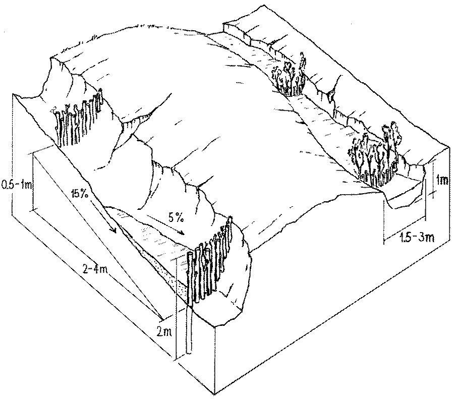
Especificações técnicas (relacionada ao desenho técnico):
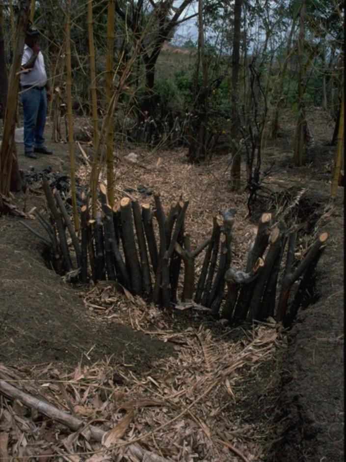
Stem cuttings planted in gullies to form living check dams: recently planted (left) and cuttings that have begun to take root and sprout, resulting in the gully becoming filled with trapped sediment (right).
Technical knowledge required for field staff / advisors: low
Technical knowledge required for land users: moderate
Main technical functions: control of concentrated runoff: retain / trap, levelling of land
Secondary technical functions: reduction of slope angle, reduction of slope length
Construction material (wood): jinocuebo (Simaroubaceaes bombacaceaes, and also jobo, tiguilote, pochote from the same family), j
Slope (which determines the spacing indicated above): 15%
Autor:
Mats Gurtner
4.3 Atividades de implantação
| Atividade | Periodicidade (estação do ano) | |
|---|---|---|
| 1. | Calculate and mark spacing between structures. | efore rainy season (April/May) |
| 2. | Cut poles out of selected local trees (diameter: 5–15 cm,length: 1.5–2.5 m depending on gully depth). | before rainy season (April/May) |
| 3. | Dig small semi-circular ditches at the gully bottom (the depth of theditch is half the length of the cuttings). | before rainy season (April/May) |
| 4. | Plant the cuttings vertically into the ditch; put the thicker cuttingsin the middle of the gully where runoff velocity is higher. | efore rainy season (April/May) |
| 5. | Fill ditch with excavated earth to fix the cuttings. | before rainy season (April/May) |
| 6. | Water to encourage rooting. | before rainy season (April/May) |
4.4 Custos e entradas necessárias para a implantação
| Especifique a entrada | Unidade | Quantidade | Custos por unidade | Custos totais por entrada | % dos custos arcados pelos usuários da terra | |
|---|---|---|---|---|---|---|
| Mão-de-obra | labour | ha | 1,0 | 100,0 | 100,0 | 100,0 |
| Equipamento | tools | ha | 1,0 | 20,0 | 20,0 | |
| Equipamento | wheelbarrow | ha | 1,0 | 10,0 | 10,0 | 100,0 |
| Material de construção | wood | ha | 1,0 | 60,0 | 60,0 | 100,0 |
| Custos totais para a implantação da tecnologia | 190,0 | |||||
| Custos totais para o estabelecimento da Tecnologia em USD | 190,0 | |||||
Comentários:
Duration of establishment phase: 2 month(s)
4.5 Atividades recorrentes/manutenção
| Atividade | Periodicidade/frequência | |
|---|---|---|
| 1. | Biotrampas: pruning the trees | every three years. |
| 2. | Cut-off drains: clearing of sediment, cutting bushes and grasses. | |
| 3. | Stone check dams: pruning trees and bushes every three years. After fullsedimentation, the dam may be increased in height. | |
| 4. | Wooden check dams: pruning trees and bushes | every three years. |
4.6 Custos e entradas necessárias pata a manutenção/atividades recorrentes (por ano)
| Especifique a entrada | Unidade | Quantidade | Custos por unidade | Custos totais por entrada | % dos custos arcados pelos usuários da terra | |
|---|---|---|---|---|---|---|
| Mão-de-obra | labour | ha | 1,0 | 30,0 | 30,0 | 100,0 |
| Material de construção | wood | ha | 1,0 | 5,0 | 5,0 | 100,0 |
| Custos totais para a manutenção da tecnologia | 35,0 | |||||
| Custos totais de manutenção da Tecnologia em USD | 35,0 | |||||
Comentários:
Costs are calculated for a 100 m long, 2 m wide and 1 m deep gully with check dams every 4 m, on the basis of one gully per hectare.
4.7 Fatores mais importantes que afetam os custos
Descreva os fatores mais determinantes que afetam os custos:
The wood (for poles) belongs to the land users themselves, thus the ‘cost’ does not involve purchase.
5. Ambiente natural e humano
5.1 Clima
Precipitação pluviométrica anual
- <250 mm
- 251-500 mm
- 501-750 mm
- 751-1.000 mm
- 1.001-1.500 mm
- 1.501-2.000 mm
- 2.001-3.000 mm
- 3.001-4.000 mm
- > 4.000 mm
Zona agroclimática
- Semiárido
5.2 Topografia
Declividade média:
- Plano (0-2%)
- Suave ondulado (3-5%)
- Ondulado (6-10%)
- Moderadamente ondulado (11-15%)
- Forte ondulado (16-30%)
- Montanhoso (31-60%)
- Escarpado (>60%)
Formas de relevo:
- Planalto/planície
- Cumes
- Encosta de serra
- Encosta de morro
- Sopés
- Fundos de vale
Zona de altitude:
- 0-100 m s.n.m.
- 101-500 m s.n.m.
- 501-1.000 m s.n.m.
- 1.001-1.500 m s.n.m.
- 1.501-2.000 m s.n.m.
- 2.001-2.500 m s.n.m.
- 2.501-3.000 m s.n.m.
- 3.001-4.000 m s.n.m.
- > 4.000 m s.n.m.
5.3 Solos
Profundidade do solo em média:
- Muito raso (0-20 cm)
- Raso (21-50 cm)
- Moderadamente profundo (51-80 cm)
- Profundo (81-120 cm)
- Muito profundo (>120 cm)
Textura do solo (solo superficial):
- Médio (limoso, siltoso)
- Fino/pesado (argila)
Matéria orgânica do solo superficial:
- Baixo (<1%)
5.6 Características dos usuários da terra que utilizam a tecnologia
Orientação de mercado do sistema de produção:
- Subsistência (autoabastecimento)
- misto (subsistência/comercial)
Rendimento não agrícola:
- 10-50% de toda renda
Indivíduos ou grupos:
- Indivíduo/unidade familiar
Indique outras características relevantes dos usuários da terra:
Off-farm income specification: temporary or permanent migration, particularly young people
5.7 Área média de terrenos utilizados pelos usuários de terrenos que aplicam a Tecnologia
- < 0,5 ha
- 0,5-1 ha
- 1-2 ha
- 2-5 ha
- 5-15 ha
- 15-50 ha
- 50-100 ha
- 100-500 ha
- 500-1.000 ha
- 1.000-10.000 ha
- > 10.000 ha
É considerado pequena, média ou grande escala (referente ao contexto local)?
- Pequena escala
5.8 Propriedade de terra, direitos de uso da terra e de uso da água
Propriedade da terra:
- Indivíduo, não intitulado
- Indivíduo, intitulado
Direitos do uso da terra:
- Arrendado
- Indivíduo
6. Impactos e declarações finais
6.1 Impactos no local mostrados pela tecnologia
Impactos socioeconômicos
Produção
Produção agrícola
Comentários/especificar:
where gullies planted
Produção de forragens
Comentários/especificar:
eg madero negro=Gliricidium sepium
Produção de madeira
Comentários/especificar:
medium term
Renda e custos
Rendimento agrícola
Carga de trabalho
Comentários/especificar:
during establishment phase
Impactos socioculturais
Instituições comunitárias
Atenuação de conflitos
improves relationships between land users
Impactos ecológicos
Solo
Umidade do solo
Perda de solo
Ciclo e recarga de nutrientes
6.2 Impactos externos mostrados pela tecnologia
Cheias de jusante
Sedimentação a jusante
Poluição de água subterrânea/rio
6.4 Análise do custo-benefício
Como os benefícios se comparam aos custos de implantação (do ponto de vista dos usuários da terra)?
Retornos a curto prazo:
negativo
Retornos a longo prazo:
positivo
Como os benefícios se comparam aos custos recorrentes/de manutenção(do ponto de vista dos usuários da terra)?
Retornos a curto prazo:
neutro/balanceado
Retornos a longo prazo:
muito positivo
6.5 Adoção da tecnologia
- > 50%
Comentários:
66% of land user families have adopted the Technology with external material support
30% of all farmers approached by the project (about 400 out of 1,200 land users) have built these check dams. Seeds, tools and credits were provided as incentives; the reasons for implementation included both the attraction of the incentives and perceived ecological benefits in terms of rehabilitation of degraded areas.
34% of land user families have adopted the Technology without any external material support
There is a strong trend towards spontaneous adoption of the Technology
6.7 Pontos fortes/vantagens/oportunidades da tecnologia
| Pontos fortes/vantagens/oportunidades na visão do/a compilador/a ou de outra pessoa capacitada |
|---|
| Facilitated land management: area is no longer divided by gullies |
| Retards runoff speed: decreases erosion |
| Accumulation of fertile earth above the check dams, possibility of growing crops on ‘terraces’ between the structures |
| Increased soil moisture |
6.8 Pontos fracos, desvantagens/riscos da tecnologia e formas de superá-los
| Pontos fracos/vantagens/riscos na visão do/a compilador/a ou de outra pessoa capacitada | Como eles podem ser superados? |
|---|---|
| The check dams used alone as SWC measure may not be adequate to withstand concentrated runoff | It is important to combine this technology with other SWC practices (e.g. retention ditches on slopes at both sides of gully, live fences, etc). |
| Only likely to be applied where land use rights are guaranteed. | |
| Labour intensive. |
7. Referências e links
7.1 Métodos/fontes de informação
- visitas de campo, pesquisas de campo
- entrevistas com usuários de terras
Quando os dados foram compilados (no campo)?
01/02/2004
7.2 Referências às publicações disponíveis
Título, autor, ano, ISBN:
Gurdiel G . La construcción de diques. Tierra Fresca, Simas-Enlace, Managua. 1993.
Título, autor, ano, ISBN:
Guía Técnica de Conservación de Suelos y Agua. PASOLAC, Managua. 2000.
Título, autor, ano, ISBN:
LUPE . Manual Práctico de Manejo de Suelos en Laderas. Secretaría de Recursos Naturales, Tegucigalpa, Honduras. 1994.
Links e módulos
Expandir tudo Recolher tudoLinks
Não há links
Módulos
Não há módulos