
Gully plug [Jordânia]
- Criação:
- Atualização:
- Compilador/a: Mira Haddad
- Editor: –
- Revisores: William Critchley, Rima Mekdaschi Studer
السدات
technologies_5862 - Jordânia
Veja as seções
Expandir tudo Recolher tudo1. Informação geral
1.2 Detalhes do contato das pessoas capacitadas e instituições envolvidas na avaliação e documentação da tecnologia
Especialista em GST:
Strohmeier Stefan
International Center of Agriculture Research in the Dry Areas (ICARDA)
Jordânia
Especialista em GST:
Especialista em GST:
Evett Steve
USDA Agricultural Research Service
Estados Unidos
Nome da(s) instituição(ões) que facilitou(ram) a documentação/ avaliação da Tecnologia (se relevante)
International Center for Agricultural Research in the Dry Areas (ICARDA) - Líbano1.3 Condições em relação ao uso da informação documentada através de WOCAT
O compilador e a(s) pessoa(s) capacitada(s) aceitam as condições relativas ao uso de dados documentados através do WOCAT:
Sim
1.4 Declaração de sustentabilidade da tecnologia descrita
A tecnologia descrita aqui é problemática em relação a degradação da terra de forma que não pode ser declarada uma tecnologia de gestão sustentável de terra?
Não
2. Descrição da tecnologia de GST
2.1 Descrição curta da tecnologia
Definição da tecnologia:
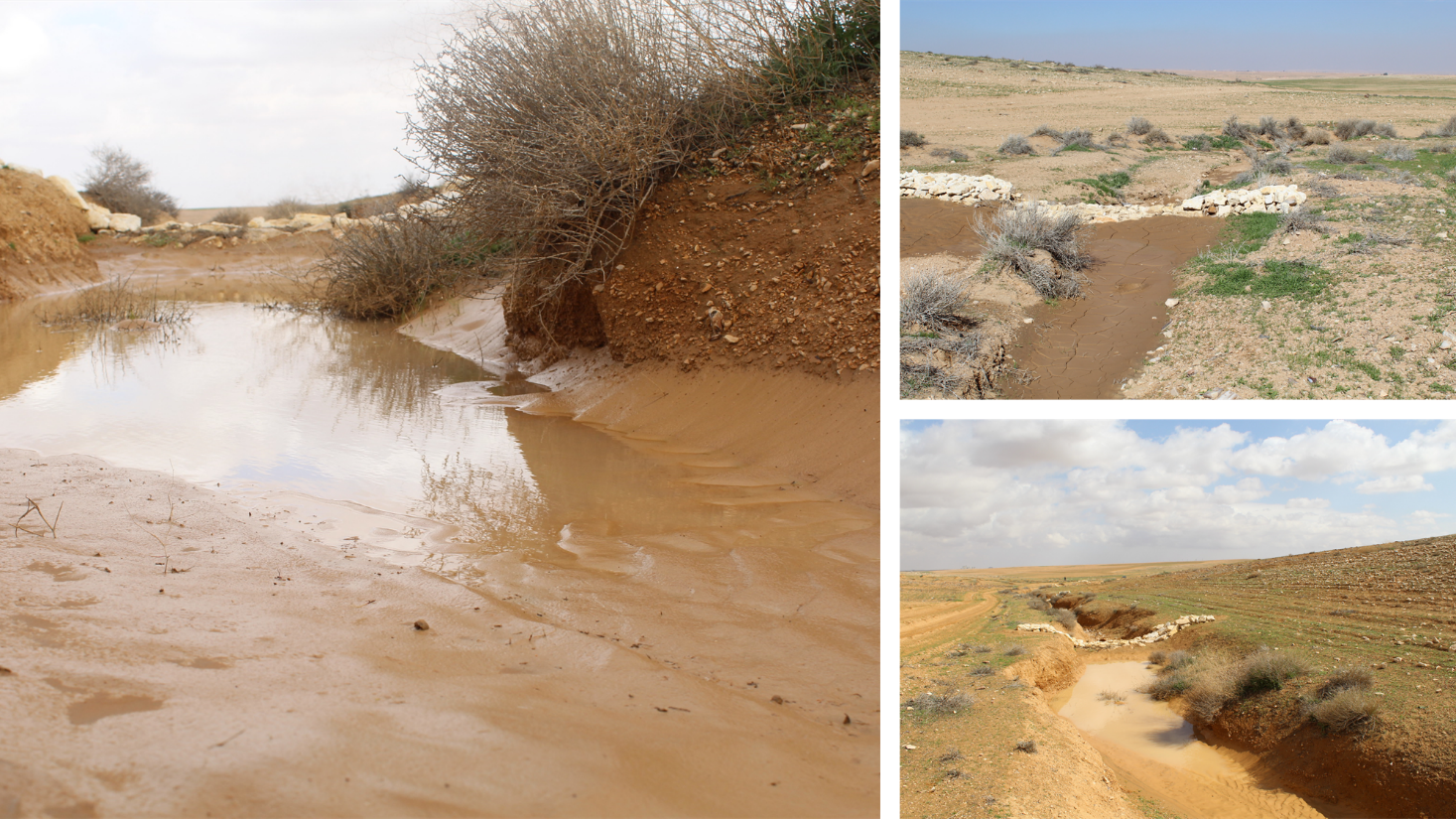
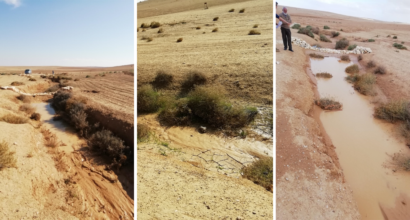
Gully plugs aim at rehabilitating active gullies in dryland watersheds, which are prone to erosion through concentrated surface runoff. Multiple gullies plugged in succession dissipate runoff energy, foster local water retention and infiltration, encourage sedimentation, assist in the stabilization of gully bed and side banks, and stimulate revegetation of flow paths; the channel measures must be combined with proper SLM in the catchments upstream.
2.2 Descrição detalhada da tecnologia
Descrição:
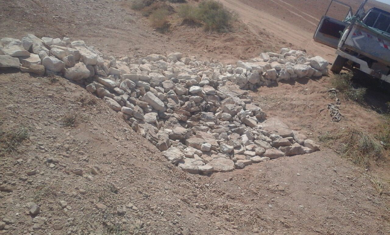
Characteristics: Multiple gully plugs positioned sequentially within a gully system interrupt concentrated surface runoff and reduce its erosive power. The plugs are each made of multiple cobbles/stones mostly ranging between 10 and 30 cm diameter and constructed to ensure a stable structure. The plugs started at the head of the gully (upstream) and ranges from 1.5 - 3.7 m in width with an average of 2.5 m. For heavily eroded and very unstable sections, gabions can be used also. The structures are around 1.0 to 1.5-m high, anchored into the sidewalls, and around 0.20 to 0.35 m deep into the gully bed, built up to around 1/3 to max. 1/2 of the gully depth - ensuring the concentrated flow stays within the channel and does not overflow the side banks. The top of the plug is U-shaped, with the sides built higher than the centre. Upslope, the plugs are packed with soil to trap sediments (stopping it flowing through the structure), and downslope the plugs have an apron to dissipate the energy of overflowing water, into a micro stilling basin. The downslope side of the gully plug is sloped rather than vertical. The large stones add roughness to the slope, creating a rough spillway that dissipates erosive energy. In the direction of gully flow, several gully plugs are placed such that the upper gully apron is set at approximately the height of the following downstream gully crest.
Environment: The technology is used in a watershed close to Al Majeddyeh village, located in the Middle Badia zone, approximately 30 km south-east of Amman. The climate is arid and warm (Palmer, 2013). The average annual rainfall is around 130 mm. The natural environment is labelled as steppe, “BSh” in the köppen classification. The human environment is characterized by agropastoralists. They are semi-nomadic and live in villages around the watershed, for example, Al Majeddyeh village.
Purpose: The measure interrupts the concentrated flow, reduces velocity, and dissipates energy. Multiple structures along the gully decrease the erosive power of runoff, retaining a fraction of the runoff, inducing sedimentation (upstream of the plug), thus protecting the gully bed from further deep-scouring, and strengthening the gully side banks, especially when this is linked with re-vegetation. Over time, the establishing vegetation (roots and surface cover) stabilizes the soil and protects it from concentrated flow erosion. To be effective, gully plug emplacement requires SLM in upland areas. These measures then jointly mitigate peak runoff generation and accordingly reduce downstream flooding.
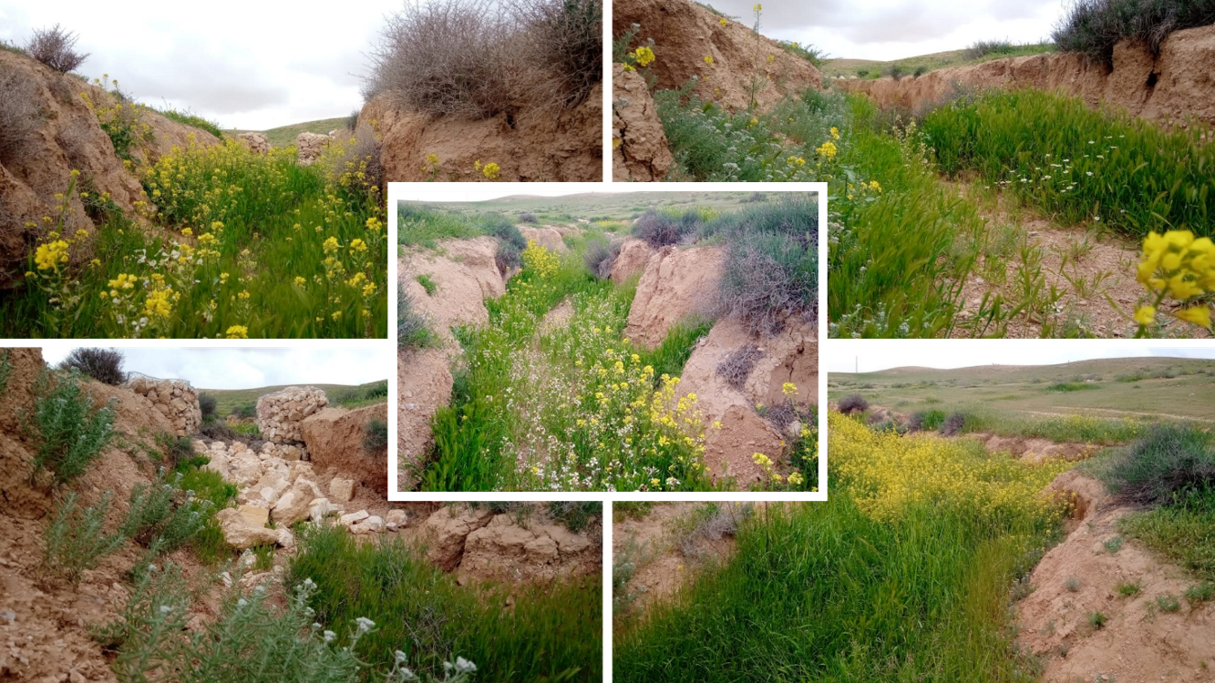
Major activities: Upland SLM is essential. In the specific watershed rehabilitation context, upland SLM was achieved through micro water harvesting and re-vegetation through native shrubs (the “VALLERANI” method). Gully morphology assessment is required for gully plug design, and positioning and earthwork excavation is necessary for foundation preparation in the gully bed and wall anchors. Proper layering of various size stones and shaping of gully plugs is necessary as is the addition of a packed soil pack upstream of the stone structure, to semi-seal the surface and to pond water. Then gully walls are revegetated through native seedlings: these benefit from the water ponding upstream prior to sedimentation upstream of the gully and enhanced soil water storage in the sediments once the gully is filled.
Benefits: Stops ongoing land degradation and gully deepening, and achieves a certain degree of rehabilitation; retains a fraction of runoff water and sediments in the watershed – water mainly infiltrates and provides moisture to the gully vegetation; gully vegetation serves various purposes including livestock fodder, reduction of flow velocities in the gully, and retention of further sediment.
Land user's opinion: Land users benefit from the vegetation (e.g. fruit trees can potentially be out-planted), as well as ponded water for livestock; however, the technology is labor-intensive, and therefore costly, and landowners (at the local target site) require incentives to carry out the work.
2.3 Fotos da tecnologia
Galeria de Mídias
2.5 País/região/locais onde a tecnologia foi aplicada e que estão cobertos nesta avaliação
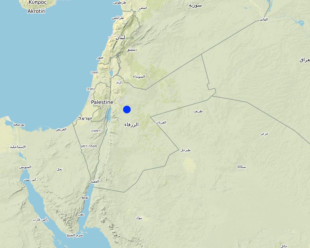
País:
Jordânia
Região/Estado/Província:
Amman governorate/Al Jizza/Al Majeddyeh village
Especifique a difusão da tecnologia:
- Aplicado em pontos específicos/concentrado numa pequena área
O(s) local(is) tecnológico(s) está(ão) localizado(s) em uma área permanentemente protegida?
Não
Map
×2.6 Data da implementação
Indique o ano de implementação:
2017
2.7 Introdução da tecnologia
Especifique como a tecnologia foi introduzida:
- durante experiências/ pesquisa
- através de projetos/intervenções externas
3. Classificação da tecnologia de GST
3.1 Principal/principais finalidade(s) da tecnologia
- Reduz, previne, recupera a degradação do solo
- Preservar/melhorar a biodiversidade
- Reduzir riscos de desastre
3.2 Tipo(s) atualizado(s) de uso da terra onde a tecnologia foi aplicada
Uso do solo misturado dentro da mesma unidade de terra:
Sim
Especificar o uso misto da terra (culturas/ pastoreio/ árvores):
- Agropecuária (incl. agricultura e pecuária)

Pastagem
Pastagem extensiva:
- Pastoralismo semi-nômade

Vias navegáveis, corpo d'água, zonas úmidas
- Linhas de drenagem, vias navegáveis
Principais produtos/serviços:
To convey and drain: Wd
3.3 O uso do solo mudou devido à implementação da Tecnologia?
O uso do solo mudou devido à implementação da Tecnologia?
- Sim (Por favor, preencha as perguntas abaixo com relação ao uso do solo antes da implementação da Tecnologia)
Uso do solo misturado dentro da mesma unidade de terra:
Não
Pastagem
Pastagem extensiva:
- Nomadismo
- Pastoralismo semi-nômade
Tipo de animal:
- caprinos
- ovelhas
É praticado o manejo integrado de culturas e pecuária?
Não
Produtos e serviços:
- carne
3.4 Abastecimento de água
Abastecimento de água para a terra na qual a tecnologia é aplicada:
- Precipitação natural
Comentários:
The measure mitigates the effect of surface runoff in concentrated flow areas - as a consequence of heavy rainfall events
3.5 Grupo de GST ao qual pertence a tecnologia
- Solo/cobertura vegetal melhorada
- Perturbação mínima ao solo
- Medidas de curva de nível
- water harvesting; surface water management (spring, river, lakes, sea, riparian zone, riverbanks, seashore, lakeshore, spring shed); ecosystem-based disaster risk reduction
3.6 Medidas de GST contendo a tecnologia

Medidas vegetativas
- V2: gramíneas e plantas herbáceas perenes

Medidas estruturais
- S6: Muros, barreiras, paliçadas, cercas

Outras medidas
Especifique:
Specify tillage system: no tillage
Specify residue management: grazed and retained
3.7 Principais tipos de degradação da terra abordados pela tecnologia

Erosão do solo pela água
- Wg: Erosão por ravinas/ravinamento
- Wo: efeitos de degradação externa

Deteriorização física do solo
- Pk: quebra e ressecamento
- Pu: perda da função bioprodutiva devido a outras atividades

Degradação da água
- Hs: mudança na quantidade de água de superfície
- Hw: redução da capacidade de tamponamento de zonas úmidas
3.8 Redução, prevenção ou recuperação da degradação do solo
Especifique o objetivo da tecnologia em relação a degradação da terra:
- Reduzir a degradação do solo
- Recuperar/reabilitar solo severamente degradado
4. Especificações técnicas, implementação de atividades, entradas e custos
4.1 Desenho técnico da tecnologia
Especificações técnicas (relacionada ao desenho técnico):
Emplacement in gully morphological system and watershed context: Determine the downstream starting point for the gully plugs and then extend upstream. The basic design is to keep the structure height maximum half the gully depth regardless of structure type. The spacing between structures is set as a gully depth function, structure crest height above the gully bed, and slope of the gully bed between structures. Additionally, the structure's final location will be shifted either upstream or downstream of the calculated gully bed level to place the structure in a more stable point if required. Following this methodology ensures variable spacing between structures to cope with both slope and depth of gully to ensure the sediment filling in between these structures occurs. In the case of distinct gully morphology and side banks that are very unstable, gabion structures can also be used/instead of a single stone pack.
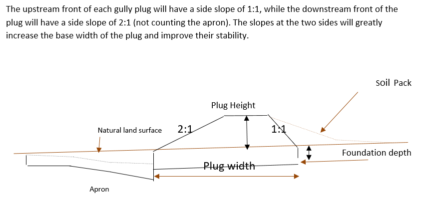
Design of the Structure: Gully plugs must be anchored strong enough to resist water flow and prevent bypass from the side banks. A foundation is also required for all structures, depending on their dimensions and the bed's nature. At the specific site, the foundation depth for the planned structures ranges between 0.2 to 0.35 meters. The anchoring of gully plugs ranges between 1 and 1.5 meters. This depends on the existing condition of the banks at each structure location. Gully plugs have a downstream apron with a length of around 3 to 4 times the height of structures. The apron starts from below the bottom level of the foundation and gradually level halfway down. All gully plugs were designed to have a height maximum of 0.5 the depth of the gully. So each structure will pass water flow downward but keeping it inside the gully. Gabion structures have a sort of spillway from the top but at the same time protecting the banks. The configuration slightly differs from the normal stone structure, but the idea is to protect the sides and a spillway in the middle. The upstream front of each gully plug has a side slope of 1:1, while the downstream front of the plug has a side slope of 2:1 (not counting the apron). The slopes at the two sides greatly increase the base width of the plug and improve their stability. The gully plugs are provided with an amount of soil resulting from the foundation to form a triangle of soil fill against the structure at the upstream side; this improves the function of the gully plugin holding more water and trapping sediments. On the other side of each structure, the downstream side's slope is meant to tackle the overflow of water along the drop to safely return to the gully bed level without causing additional erosion. The rock-filled apron catches the flow and acts to dissipate erosive energy.
Autor:
Steve Evett
Data:
15/08/2017
4.2 Informação geral em relação ao cálculo de entradas e custos
Especifique como custos e entradas foram calculados:
- Por unidade de tecnologia
Especifique a unidade:
Gully plug
Especifique a moeda utilizada para os cálculos de custo:
- USD
4.3 Atividades de implantação
| Atividade | Periodicidade (estação do ano) | |
|---|---|---|
| 1. | Implement upland watershed SLM (reference VALLERANI) | |
| 2. | Gully system/morphological assessment | |
| 3. | Determine plug design and implementation in the watershed | |
| 4. | Excavation earthworks for anchors and foundation | At least 2 months prior rainy season onset |
| 5. | Stone made construction of gully plugs (occasionally with gabions) | At least 1 month prior rainy season onset |
| 6. | Soil pack at upstream front | At least 1 month prior rainy season onset |
| 7. | Revegetation of gully side banks | At the onset of the rainy season |
Comentários:
Gully plugs require proper SLM in the uplands. Revegetation of gully side banks is optional – depending on the recovery potential of the area.
4.4 Custos e entradas necessárias para a implantação
| Especifique a entrada | Unidade | Quantidade | Custos por unidade | Custos totais por entrada | % dos custos arcados pelos usuários da terra | |
|---|---|---|---|---|---|---|
| Mão-de-obra | Field technician (design and oversight) | Labour Day (LD) per structure | 0,2 | 50,0 | 10,0 | |
| Mão-de-obra | Workers (excavation/earthworks) | LD | 4,0 | 35,0 | 140,0 | |
| Mão-de-obra | Workers (stone layering/construction) | LD | 4,0 | 35,0 | 140,0 | |
| Mão-de-obra | Worker (out-planting of seedlings) | LD | 1,0 | 35,0 | 35,0 | |
| Equipamento | Shovel, Pickaxe, buckets, ruler | Lump sum | 1,0 | 10,0 | 10,0 | |
| Material vegetal | Seedlings | per item | 10,0 | 0,5 | 5,0 | |
| Material de construção | Stones | m3 | 4,0 | 10,0 | 40,0 | |
| Outros | Logistics (seedling transport, local stone transport) | lump sum | 1,0 | 10,0 | 10,0 | |
| Custos totais para a implantação da tecnologia | 390,0 | |||||
| Custos totais para o estabelecimento da Tecnologia em USD | 390,0 | |||||
Se o usuário da terra arca com menos que 100% dos custos, indique quem cobre os custos remanescentes:
International research for the development project.
Comentários:
Design is tailored for implementation through local workers (rural agro-pastoral community) and local materials. The engagement of local community workers as part of the specific project; if a professional contractor is hired costs can be significantly reduced.
4.5 Atividades recorrentes/manutenção
| Atividade | Periodicidade/frequência | |
|---|---|---|
| 1. | Inspect damage/status | After severe storms and runoff events |
| 2. | Maintain/repair/improve | After inspection |
Comentários:
If optimally designed and connected with proper upland SLM the gully plug technology would not require maintenance; the measure induces nature-based (vegetation) protection of vulnerable gully zones over time.
4.6 Custos e entradas necessárias pata a manutenção/atividades recorrentes (por ano)
| Especifique a entrada | Unidade | Quantidade | Custos por unidade | Custos totais por entrada | % dos custos arcados pelos usuários da terra | |
|---|---|---|---|---|---|---|
| Mão-de-obra | Expert (investigation) | LD | 0,1 | 50,0 | 5,0 | |
| Mão-de-obra | LD | 0,5 | 35,0 | 17,5 | ||
| Mão-de-obra | LD | 1,0 | 35,0 | 35,0 | ||
| Material de construção | stones | m3 | 0,5 | 10,0 | 5,0 | |
| Custos totais para a manutenção da tecnologia | 62,5 | |||||
| Custos totais de manutenção da Tecnologia em USD | 62,5 | |||||
Se o usuário da terra arca com menos que 100% dos custos, indique quem cobre os custos remanescentes:
It is 100% covered by the research project
Comentários:
Maintenance might be needed in case of improper implementation and/or extreme event occurrence. Maintenance should be minimal - mostly after initial 1-2 rainy seasons. Thereafter, revegetated and rehabilitated gully system – and most importantly, the rehabilitated uplands - would take on hydrological buffering functions and withstand the erosive force of surface runoff.
4.7 Fatores mais importantes que afetam os custos
Descreva os fatores mais determinantes que afetam os custos:
The most distinct cost factor is labor – which is especially significant when using local (community) labor; some technical training is required.
5. Ambiente natural e humano
5.1 Clima
Precipitação pluviométrica anual
- <250 mm
- 251-500 mm
- 501-750 mm
- 751-1.000 mm
- 1.001-1.500 mm
- 1.501-2.000 mm
- 2.001-3.000 mm
- 3.001-4.000 mm
- > 4.000 mm
Especifique a média pluviométrica anual em mm (se conhecida):
130,00
Especificações/comentários sobre a pluviosidade:
Jordan has a rainy season from September to May – but locally, the effective rainy season sets on later (November or December) and lasts until April.
Indique o nome da estação meteorológica de referência considerada:
Queen Alia international airport reference station reports long term average annual rainfall of about 150 mm A rainfall tipping bucket installed in the site in 2016.
Zona agroclimática
- Árido
5.2 Topografia
Declividade média:
- Plano (0-2%)
- Suave ondulado (3-5%)
- Ondulado (6-10%)
- Moderadamente ondulado (11-15%)
- Forte ondulado (16-30%)
- Montanhoso (31-60%)
- Escarpado (>60%)
Formas de relevo:
- Planalto/planície
- Cumes
- Encosta de serra
- Encosta de morro
- Sopés
- Fundos de vale
Zona de altitude:
- 0-100 m s.n.m.
- 101-500 m s.n.m.
- 501-1.000 m s.n.m.
- 1.001-1.500 m s.n.m.
- 1.501-2.000 m s.n.m.
- 2.001-2.500 m s.n.m.
- 2.501-3.000 m s.n.m.
- 3.001-4.000 m s.n.m.
- > 4.000 m s.n.m.
Indique se a tecnologia é aplicada especificamente em:
- Posições côncavas
Comentários e outras especificações sobre a topografia:
Gully slope is 3.4% on average.
5.3 Solos
Profundidade do solo em média:
- Muito raso (0-20 cm)
- Raso (21-50 cm)
- Moderadamente profundo (51-80 cm)
- Profundo (81-120 cm)
- Muito profundo (>120 cm)
Textura do solo (solo superficial):
- Médio (limoso, siltoso)
- Fino/pesado (argila)
Textura do solo (>20 cm abaixo da superfície):
- Médio (limoso, siltoso)
- Fino/pesado (argila)
Matéria orgânica do solo superficial:
- Baixo (<1%)
Caso disponível anexe a descrição completa do solo ou especifique as informações disponíveis, p. ex. tipo de solo, PH/acidez do solo, nitrogênio, capacidade de troca catiônica, salinidade, etc.
Soil depth is varying throughout the gully areas. At some points (mostly upstream) the gully bed reaches the bedrock
5.4 Disponibilidade e qualidade de água
Lençol freático:
> 50 m
Disponibilidade de água de superfície:
Médio
Qualidade da água (não tratada):
apenas para uso agrícola (irrigação)
A qualidade da água refere-se a:
água de superfície
A salinidade da água é um problema?
Não
Ocorre inundação da área?
Sim
Regularidade:
Frequentemente
5.5 Biodiversidade
Diversidade de espécies:
- Alto
Diversidade de habitat:
- Médio
Comentários e outras especificações sobre biodiversidade:
Gully plugs with out-planted vegetation create micro-climates; after recruitment and emergence of seed material, biodiversity increases.
5.6 Características dos usuários da terra que utilizam a tecnologia
Sedentário ou nômade:
- Sedentário
- Semi-nômade
Rendimento não agrícola:
- Menos de 10% de toda renda
Nível relativo de riqueza:
- Muito pobre
- Pobre
Indivíduos ou grupos:
- Indivíduo/unidade familiar
- Grupos/comunidade
Nível de mecanização:
- Trabalho manual
Gênero:
- Homens
Idade dos usuários da terra:
- Jovens
- meia-idade
5.7 Área média de terrenos utilizados pelos usuários de terrenos que aplicam a Tecnologia
- < 0,5 ha
- 0,5-1 ha
- 1-2 ha
- 2-5 ha
- 5-15 ha
- 15-50 ha
- 50-100 ha
- 100-500 ha
- 500-1.000 ha
- 1.000-10.000 ha
- > 10.000 ha
É considerado pequena, média ou grande escala (referente ao contexto local)?
- Grande escala
Comentários:
The entire watershed area affected by gully plugs is 160 hectares.
The total constructed plugs are 55.
5.8 Propriedade de terra, direitos de uso da terra e de uso da água
Propriedade da terra:
- Indivíduo, intitulado
Direitos do uso da terra:
- Indivíduo
Os direitos de uso da terra são baseados em um sistema jurídico tradicional?
Sim
5.9 Acesso a serviços e infraestrutura
Saúde:
- Pobre
- Moderado
- Bom
Educação:
- Pobre
- Moderado
- Bom
Assistência técnica:
- Pobre
- Moderado
- Bom
Emprego (p. ex. não agrícola):
- Pobre
- Moderado
- Bom
Mercados:
- Pobre
- Moderado
- Bom
Energia:
- Pobre
- Moderado
- Bom
Vias e transporte:
- Pobre
- Moderado
- Bom
Água potável e saneamento:
- Pobre
- Moderado
- Bom
Serviços financeiros:
- Pobre
- Moderado
- Bom
6. Impactos e declarações finais
6.1 Impactos no local mostrados pela tecnologia
Impactos socioeconômicos
Produção
Produção de forragens
Qualidade da forragem
Disponibilidade e qualidade de água
Disponibilidade de água para criação de animais
Impactos socioculturais
Segurança alimentar/auto-suficiência
Comentários/especificar:
Some herbs (and fruits (trees) in the future)
Oportunidades de lazer
Comentários/especificar:
enhanced biodiversity, shade and shelter
Conhecimento de GST/ degradação da terra
Comentários/especificar:
Through training/community participation
Impactos ecológicos
Ciclo hídrico/escoamento
Qualidade de água
Comentários/especificar:
Certain degree purification through infiltration in the sediment accumulation zone
Colheita/recolhimento de água
Escoamento superficial
Comentários/especificar:
Effect on hydrology (distinctness of runoff peak)
Lençol freático/aquífero
Comentários/especificar:
Certain deep-infiltration
Evaporação
Comentários/especificar:
more open water ponding – but also deep-infiltration and beneficial use for vegetation (transpiration)
Solo
Umidade do solo
Cobertura do solo
Perda de solo
Comentários/especificar:
Side banks stabilized
Acumulação de solo
Comentários/especificar:
sediments trapped
Ressecamento/ selagem do solo
Comentários/especificar:
sediment crust increased in the ponding area – but better soil structure at the side banks (revegetation) – overall positive impact.
Biodiversidade: vegetação, animais
Cobertura vegetal
Biomassa/carbono acima do solo
Diversidade vegetal
Diversidade animal
Espécies benéficas
Clima e redução de riscos de desastre
Impactos da inundação
Deslizamentos de terra/fluxos de escombros
Comentários/especificar:
Through side bank stabilization.
Microclima
6.2 Impactos externos mostrados pela tecnologia
Cheias de jusante
Sedimentação a jusante
Comentários/especificar:
especially when combined with upland measure: reference VALLERANI
Danos em áreas vizinhas
Comentários/especificar:
Less tributary channel development (connectivity of upland areas); less downstream siltation
Danos na infraestrutura pública/privada
Comentários/especificar:
less runoff peakiness and siltation
6.3 Exposição e sensibilidade da tecnologia às mudanças climáticas graduais e extremos/desastres relacionados ao clima (conforme o ponto de vista dos usuários da terra)
Mudança climática gradual
Mudança climática gradual
| Estação do ano | aumento ou diminuição | Como a tecnologia lida com isso? | |
|---|---|---|---|
| Temperatura anual | aumento | moderadamente | |
| Precipitação pluviométrica anual | redução/diminuição | bem |
Extremos (desastres) relacionados ao clima
Desastres meteorológicos
| Como a tecnologia lida com isso? | |
|---|---|
| Temporal local | bem |
Desastres hidrológicos
| Como a tecnologia lida com isso? | |
|---|---|
| Inundação súbita | muito bem |
Desastres biológicos
| Como a tecnologia lida com isso? | |
|---|---|
| Doenças epidêmicas | bem |
Outras consequências relacionadas ao clima
Outras consequências relacionadas ao clima
| Como a tecnologia lida com isso? | |
|---|---|
| Período de crescimento alogado | muito bem |
6.4 Análise do custo-benefício
Como os benefícios se comparam aos custos de implantação (do ponto de vista dos usuários da terra)?
Retornos a curto prazo:
negativo
Retornos a longo prazo:
positivo
Como os benefícios se comparam aos custos recorrentes/de manutenção(do ponto de vista dos usuários da terra)?
Retornos a curto prazo:
negativo
Retornos a longo prazo:
levemente positivo
Comentários:
During the initial stage potential benefits through vegetation do not materialize; main effects are on water and sediment retention. Long-term, the technology fosters the rehabilitation nature-based retention functions (very limited long-term maintenance required).
6.5 Adoção da tecnologia
- casos isolados/experimental
Se disponível, determine a quantidade (número de unidades familiares e/ou área abordada):
1
De todos aqueles que adotaram a Tecnologia, quantos o fizeram espontaneamente, ou seja, sem receber nenhum incentivo/ pagamento material?
- 0-10%
6.6 Adaptação
A tecnologia foi recentemente modificada para adaptar-se as condições variáveis?
Não
6.7 Pontos fortes/vantagens/oportunidades da tecnologia
| Pontos fortes/vantagens/oportunidades na visão do usuário da terra |
|---|
| Gully side bank vegetation useable as (livestock) fodder source; some herbs (later fruit tree benefits) for human consumption. |
| Gully is stable and does not expand e.g. tributaries. Uplands remain connected and productive. |
| Ponded water for livestock watering (during the rainy season). |
| Shelter and shade through vegetation. |
| Pontos fortes/vantagens/oportunidades na visão do compilador ou de outra pessoa capacitada |
|---|
| Sediments from the uplands are trapped; relatively fertile soil remains in the watershed. |
| Increased local soil moisture and consequential vegetation quantity and bio-diversity enhancement; increase carbon storage and other ecosystem services such as pollination. |
| Smoothened watershed hydrology is beneficial for downstream agriculture – especially when applied in a watershed context with downstream flood irrigation (MARAB) |
| Protection of downstream infrastructure (flooding and sediments). |
6.8 Pontos fracos, desvantagens/riscos da tecnologia e formas de superá-los
| Pontos fracos/desvantagens/riscos na visão do usuário da terra | Como eles podem ser superados? |
|---|---|
| implementation costs | Incentives (e.g. governmental) for communities to implement SLM; regulations and enforcement on environmental management – especially connected with entitlements of natural resources facilitation |
| Tensions between upstream and downstream watershed users (watershed hydrology) – especially affected through wrong design and failure (e.g. gully breakage) | Community-based and holistic watershed management – the share of benefits and commitment for maintenance. |
| Additional fodder supply might attract other foreign herders (overgrazing) | Community-based and holistic watershed management – and protection. |
| Technical skills needed for implementation | Rural communities’ capacity building programs |
| Pontos fracos/vantagens/riscos na visão do compilador ou de outra pessoa capacitada | Como eles podem ser superados? |
|---|---|
| Expert design and implementation support required | Governmental and environmental organizations in control of design and support to local communities (training). |
| Requires upland SLM | Integrated watershed management and empowerment of local communities to manage and facilitate – provision of support (e.g. government and/or international projects). |
| Increased vegetation in a fragile ecosystem can lead to local pressure | Integrated watershed management and empowerment of local communities – especially sustainable grazing plans |
| Risk of wrong lessons learned: large water harvesting in gully systems (dams) created by locals | Capacity development programs; regulations and enforcement on environmental management. |
7. Referências e links
7.1 Métodos/fontes de informação
- visitas de campo, pesquisas de campo
The number of field visit is 5.
- entrevistas com usuários de terras
The number of land users that were interviewed is 10.
- entrevistas com especialistas em GST
The number of SLM experts who were interviewed is 5.
Quando os dados foram compilados (no campo)?
09/08/2020
7.2 Referências às publicações disponíveis
Título, autor, ano, ISBN:
Steven, E. (2017). Report on Majiddya Watershed Rehabilitation Project - Gully Plugs Plan /August 2017.
Título, autor, ano, ISBN:
Strohmeier, S. (2017). Dimensioning of Marab in Majidyya.
Título, autor, ano, ISBN:
SEA. 1974. Les ouvrages en gabions – techniques rurales en Afrique. Secretariat d’Etat aux Affaires Etrangeres, Republique Francaise, 20, rue Monsieur, 75007 Paris.
Título, autor, ano, ISBN:
FAO. 1977. Guidelines for watershed management. FAO Conservation Guide 1. Food and Agriculture Organization of the United Nations. Rome, 1977
Links e módulos
Expandir tudo Recolher tudoLinks
Não há links
Módulos
Não há módulos