
Gully plug [约旦]
- 创建:
- 更新:
- 编制者: Mira Haddad
- 编辑者: –
- 审查者: William Critchley, Rima Mekdaschi Studer
السدات
technologies_5862 - 约旦
查看章节
全部展开 全部收起1. 一般信息
1.2 参与该技术评估和文件编制的资源人员和机构的联系方式
SLM专业人员:
Strohmeier Stefan
International Center of Agriculture Research in the Dry Areas (ICARDA)
约旦
SLM专业人员:
SLM专业人员:
Evett Steve
USDA Agricultural Research Service
美国
有助于对技术进行记录/评估的机构名称(如相关)
International Center for Agricultural Research in the Dry Areas (ICARDA) - 黎巴嫩1.3 关于使用通过WOCAT记录的数据的条件
编制者和关键资源人员接受有关使用通过WOCAT记录数据的条件。:
是
1.4 所述技术的可持续性声明
这里所描述的技术在土地退化方面是否存在问题,导致无法被认为是一种可持续的土地管理技术?:
否
2. SLM技术的说明
2.1 技术简介
技术定义:
Gully plugs aim at rehabilitating active gullies in dryland watersheds, which are prone to erosion through concentrated surface runoff. Multiple gullies plugged in succession dissipate runoff energy, foster local water retention and infiltration, encourage sedimentation, assist in the stabilization of gully bed and side banks, and stimulate revegetation of flow paths; the channel measures must be combined with proper SLM in the catchments upstream.
2.2 技术的详细说明
说明:
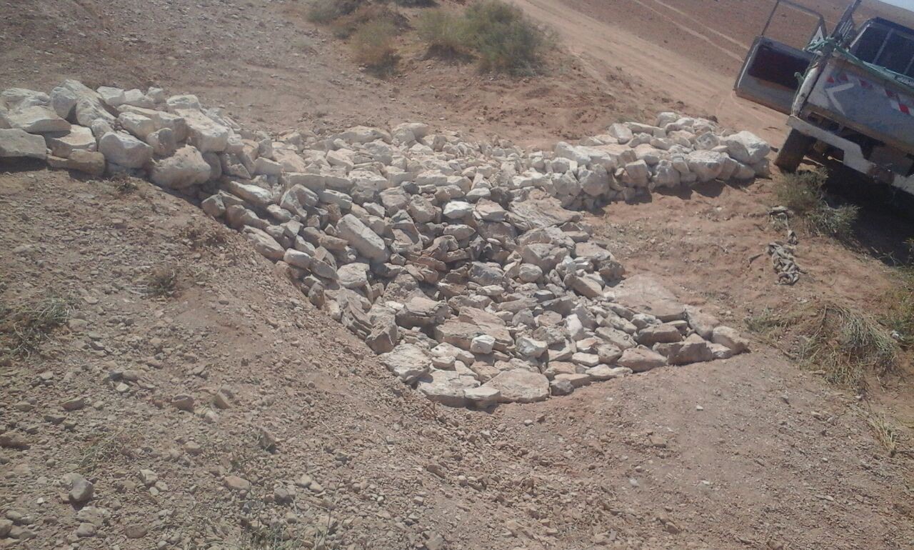
Characteristics: Multiple gully plugs positioned sequentially within a gully system interrupt concentrated surface runoff and reduce its erosive power. The plugs are each made of multiple cobbles/stones mostly ranging between 10 and 30 cm diameter and constructed to ensure a stable structure. The plugs started at the head of the gully (upstream) and ranges from 1.5 - 3.7 m in width with an average of 2.5 m. For heavily eroded and very unstable sections, gabions can be used also. The structures are around 1.0 to 1.5-m high, anchored into the sidewalls, and around 0.20 to 0.35 m deep into the gully bed, built up to around 1/3 to max. 1/2 of the gully depth - ensuring the concentrated flow stays within the channel and does not overflow the side banks. The top of the plug is U-shaped, with the sides built higher than the centre. Upslope, the plugs are packed with soil to trap sediments (stopping it flowing through the structure), and downslope the plugs have an apron to dissipate the energy of overflowing water, into a micro stilling basin. The downslope side of the gully plug is sloped rather than vertical. The large stones add roughness to the slope, creating a rough spillway that dissipates erosive energy. In the direction of gully flow, several gully plugs are placed such that the upper gully apron is set at approximately the height of the following downstream gully crest.
Environment: The technology is used in a watershed close to Al Majeddyeh village, located in the Middle Badia zone, approximately 30 km south-east of Amman. The climate is arid and warm (Palmer, 2013). The average annual rainfall is around 130 mm. The natural environment is labelled as steppe, “BSh” in the köppen classification. The human environment is characterized by agropastoralists. They are semi-nomadic and live in villages around the watershed, for example, Al Majeddyeh village.
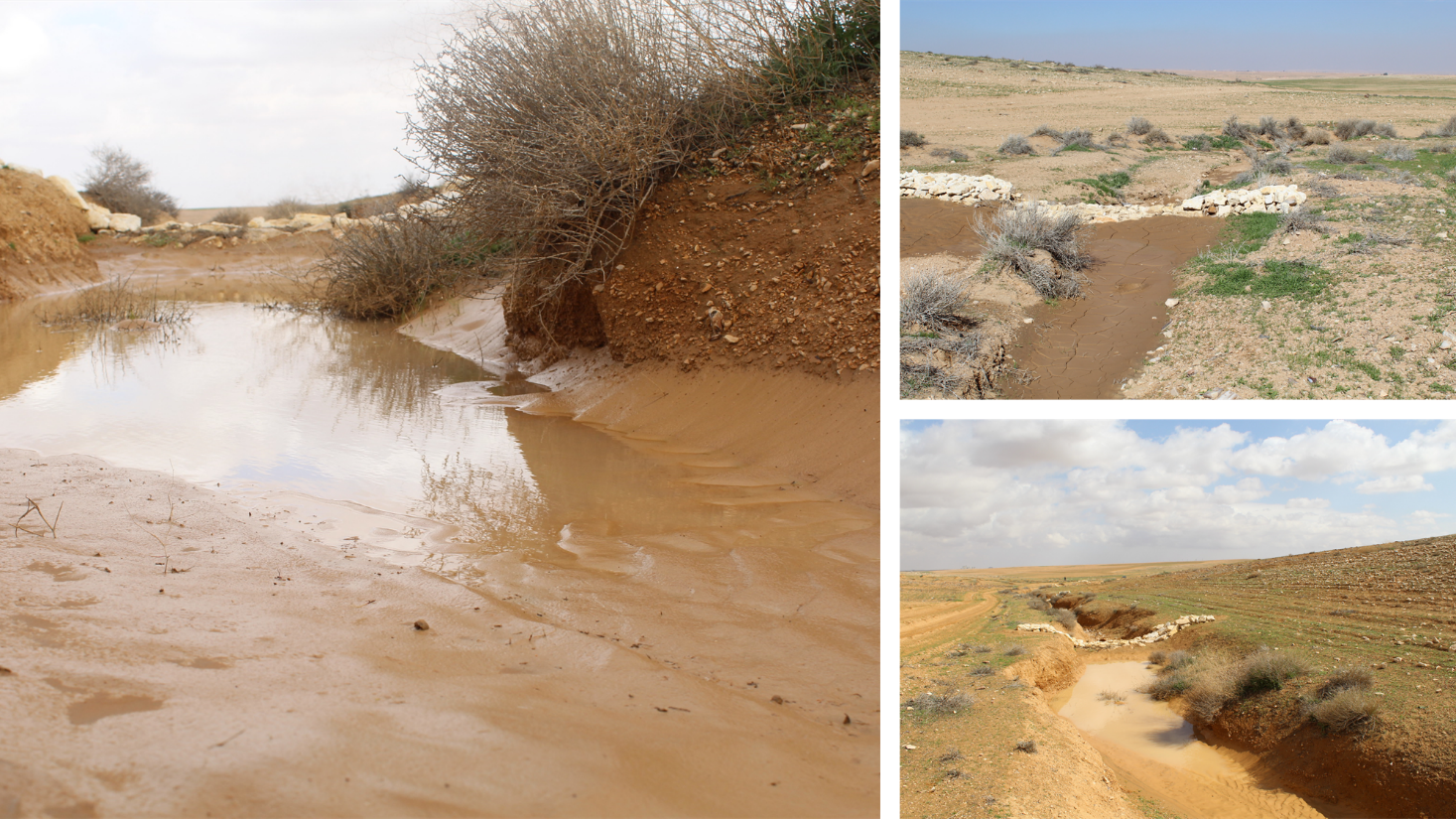
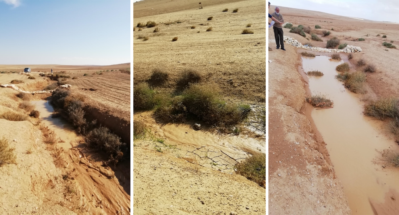
Purpose: The measure interrupts the concentrated flow, reduces velocity, and dissipates energy. Multiple structures along the gully decrease the erosive power of runoff, retaining a fraction of the runoff, inducing sedimentation (upstream of the plug), thus protecting the gully bed from further deep-scouring, and strengthening the gully side banks, especially when this is linked with re-vegetation. Over time, the establishing vegetation (roots and surface cover) stabilizes the soil and protects it from concentrated flow erosion. To be effective, gully plug emplacement requires SLM in upland areas. These measures then jointly mitigate peak runoff generation and accordingly reduce downstream flooding.
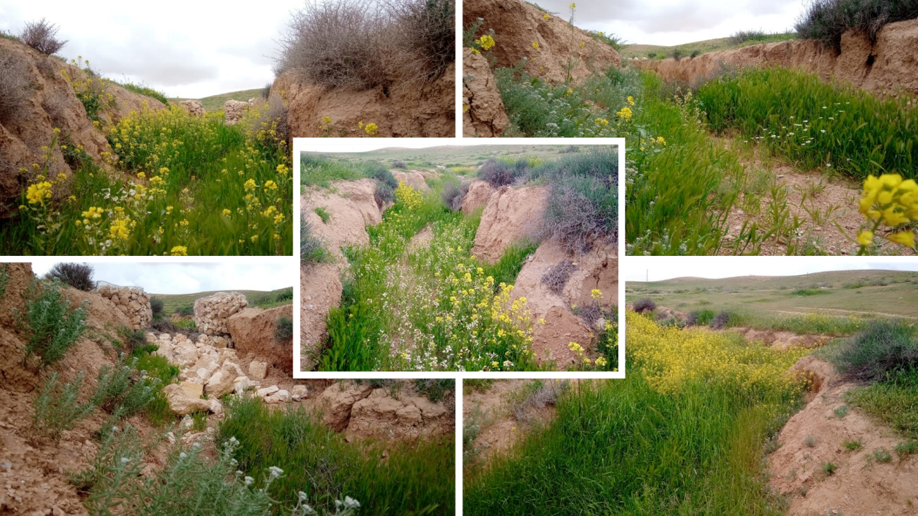
Major activities: Upland SLM is essential. In the specific watershed rehabilitation context, upland SLM was achieved through micro water harvesting and re-vegetation through native shrubs (the “VALLERANI” method). Gully morphology assessment is required for gully plug design, and positioning and earthwork excavation is necessary for foundation preparation in the gully bed and wall anchors. Proper layering of various size stones and shaping of gully plugs is necessary as is the addition of a packed soil pack upstream of the stone structure, to semi-seal the surface and to pond water. Then gully walls are revegetated through native seedlings: these benefit from the water ponding upstream prior to sedimentation upstream of the gully and enhanced soil water storage in the sediments once the gully is filled.
Benefits: Stops ongoing land degradation and gully deepening, and achieves a certain degree of rehabilitation; retains a fraction of runoff water and sediments in the watershed – water mainly infiltrates and provides moisture to the gully vegetation; gully vegetation serves various purposes including livestock fodder, reduction of flow velocities in the gully, and retention of further sediment.
Land user's opinion: Land users benefit from the vegetation (e.g. fruit trees can potentially be out-planted), as well as ponded water for livestock; however, the technology is labor-intensive, and therefore costly, and landowners (at the local target site) require incentives to carry out the work.
2.3 技术照片
媒体库
2.5 已应用该技术的、本评估所涵盖的国家/地区/地点
国家:
约旦
区域/州/省:
Amman governorate/Al Jizza/Al Majeddyeh village
具体说明该技术的分布:
- 适用于特定场所/集中在较小区域
技术现场是否位于永久保护区?:
否
Map
×2.6 实施日期
注明实施年份:
2017
2.7 技术介绍
详细说明该技术是如何引入的:
- 在实验/研究期间
- 通过项目/外部干预
3. SLM技术的分类
3.1 该技术的主要目的
- 减少、预防、恢复土地退化
- 保持/提高生物多样性
- 降低灾害风险
3.2 应用该技术的当前土地利用类型
同一土地单元内混合使用的土地::
是
具体说明混合土地使用(作物/放牧/树木):
- 农牧业(包括农牧结合)

牧场
粗放式放牧:
- 半游牧畜牧业

水道、水体、湿地
- 排水管道、水道
主要产品/服务:
To convey and drain: Wd
3.3 由于技术的实施,土地使用是否发生了变化?
由于技术的实施,土地使用是否发生了变化?:
- 是(请在技术实施前填写以下有关土地利用的问题)
同一土地单元内混合使用的土地::
否
牧场
粗放式放牧:
- 游牧
- 半游牧畜牧业
动物类型:
- 山羊
- 绵羊
是否实行作物与牲畜的综合管理?:
否
产品和服务:
- 肉类
3.4 供水
该技术所应用土地的供水:
- 雨养
注释:
The measure mitigates the effect of surface runoff in concentrated flow areas - as a consequence of heavy rainfall events
3.5 该技术所属的SLM组
- 改良的地面/植被覆盖
- 最小的土壤扰动
- 横坡措施
- water harvesting; surface water management (spring, river, lakes, sea, riparian zone, riverbanks, seashore, lakeshore, spring shed); ecosystem-based disaster risk reduction
3.6 包含该技术的可持续土地管理措施

植物措施
- V2:草和多年生草本植物

结构措施
- S6:墙、障碍物、栅栏、围墙
其它措施
具体说明:
Specify tillage system: no tillage
Specify residue management: grazed and retained
3.7 该技术强调的主要土地退化类型

土壤水蚀
- Wg:冲沟侵蚀/沟蚀
- Wo:场外劣化效应

物理性土壤退化
- Pk:熟化和结壳
- Pu:由于其他活动而导致生物生产功能的丧失

水质恶化
- Hs:地表水良变化
- Hw:湿地缓冲能力下降
3.8 防止、减少或恢复土地退化
具体数量名该技术与土地退化有关的目标:
- 减少土地退化
- 修复/恢复严重退化的土地
4. 技术规范、实施活动、投入和成本
4.1 该技术的技术图纸
技术规范(与技术图纸相关):
Emplacement in gully morphological system and watershed context: Determine the downstream starting point for the gully plugs and then extend upstream. The basic design is to keep the structure height maximum half the gully depth regardless of structure type. The spacing between structures is set as a gully depth function, structure crest height above the gully bed, and slope of the gully bed between structures. Additionally, the structure's final location will be shifted either upstream or downstream of the calculated gully bed level to place the structure in a more stable point if required. Following this methodology ensures variable spacing between structures to cope with both slope and depth of gully to ensure the sediment filling in between these structures occurs. In the case of distinct gully morphology and side banks that are very unstable, gabion structures can also be used/instead of a single stone pack.
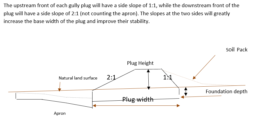
Design of the Structure: Gully plugs must be anchored strong enough to resist water flow and prevent bypass from the side banks. A foundation is also required for all structures, depending on their dimensions and the bed's nature. At the specific site, the foundation depth for the planned structures ranges between 0.2 to 0.35 meters. The anchoring of gully plugs ranges between 1 and 1.5 meters. This depends on the existing condition of the banks at each structure location. Gully plugs have a downstream apron with a length of around 3 to 4 times the height of structures. The apron starts from below the bottom level of the foundation and gradually level halfway down. All gully plugs were designed to have a height maximum of 0.5 the depth of the gully. So each structure will pass water flow downward but keeping it inside the gully. Gabion structures have a sort of spillway from the top but at the same time protecting the banks. The configuration slightly differs from the normal stone structure, but the idea is to protect the sides and a spillway in the middle. The upstream front of each gully plug has a side slope of 1:1, while the downstream front of the plug has a side slope of 2:1 (not counting the apron). The slopes at the two sides greatly increase the base width of the plug and improve their stability. The gully plugs are provided with an amount of soil resulting from the foundation to form a triangle of soil fill against the structure at the upstream side; this improves the function of the gully plugin holding more water and trapping sediments. On the other side of each structure, the downstream side's slope is meant to tackle the overflow of water along the drop to safely return to the gully bed level without causing additional erosion. The rock-filled apron catches the flow and acts to dissipate erosive energy.
作者:
Steve Evett
日期:
15/08/2017
4.2 有关投入和成本计算的一般信息
具体说明成本和投入是如何计算的:
- 每个技术单元
指定单位:
Gully plug
具体说明成本计算所用货币:
- 美元
4.3 技术建立活动
| 活动 | 时间(季度) | |
|---|---|---|
| 1. | Implement upland watershed SLM (reference VALLERANI) | |
| 2. | Gully system/morphological assessment | |
| 3. | Determine plug design and implementation in the watershed | |
| 4. | Excavation earthworks for anchors and foundation | At least 2 months prior rainy season onset |
| 5. | Stone made construction of gully plugs (occasionally with gabions) | At least 1 month prior rainy season onset |
| 6. | Soil pack at upstream front | At least 1 month prior rainy season onset |
| 7. | Revegetation of gully side banks | At the onset of the rainy season |
注释:
Gully plugs require proper SLM in the uplands. Revegetation of gully side banks is optional – depending on the recovery potential of the area.
4.4 技术建立所需要的费用和投入
| 对投入进行具体说明 | 单位 | 数量 | 单位成本 | 每项投入的总成本 | 土地使用者承担的成本% | |
|---|---|---|---|---|---|---|
| 劳动力 | Field technician (design and oversight) | Labour Day (LD) per structure | 0.2 | 50.0 | 10.0 | |
| 劳动力 | Workers (excavation/earthworks) | LD | 4.0 | 35.0 | 140.0 | |
| 劳动力 | Workers (stone layering/construction) | LD | 4.0 | 35.0 | 140.0 | |
| 劳动力 | Worker (out-planting of seedlings) | LD | 1.0 | 35.0 | 35.0 | |
| 设备 | Shovel, Pickaxe, buckets, ruler | Lump sum | 1.0 | 10.0 | 10.0 | |
| 植物材料 | Seedlings | per item | 10.0 | 0.5 | 5.0 | |
| 施工材料 | Stones | m3 | 4.0 | 10.0 | 40.0 | |
| 其它 | Logistics (seedling transport, local stone transport) | lump sum | 1.0 | 10.0 | 10.0 | |
| 技术建立所需总成本 | 390.0 | |||||
| 技术建立总成本,美元 | 390.0 | |||||
如果土地使用者负担的费用少于100%,请注明由谁负担其余费用:
International research for the development project.
注释:
Design is tailored for implementation through local workers (rural agro-pastoral community) and local materials. The engagement of local community workers as part of the specific project; if a professional contractor is hired costs can be significantly reduced.
4.5 维护/经常性活动
| 活动 | 时间/频率 | |
|---|---|---|
| 1. | Inspect damage/status | After severe storms and runoff events |
| 2. | Maintain/repair/improve | After inspection |
注释:
If optimally designed and connected with proper upland SLM the gully plug technology would not require maintenance; the measure induces nature-based (vegetation) protection of vulnerable gully zones over time.
4.6 维护/经常性活动所需要的费用和投入(每年)
| 对投入进行具体说明 | 单位 | 数量 | 单位成本 | 每项投入的总成本 | 土地使用者承担的成本% | |
|---|---|---|---|---|---|---|
| 劳动力 | Expert (investigation) | LD | 0.1 | 50.0 | 5.0 | |
| 劳动力 | LD | 0.5 | 35.0 | 17.5 | ||
| 劳动力 | LD | 1.0 | 35.0 | 35.0 | ||
| 施工材料 | stones | m3 | 0.5 | 10.0 | 5.0 | |
| 技术维护所需总成本 | 62.5 | |||||
| 技术维护总成本,美元 | 62.5 | |||||
如果土地使用者负担的费用少于100%,请注明由谁负担其余费用:
It is 100% covered by the research project
注释:
Maintenance might be needed in case of improper implementation and/or extreme event occurrence. Maintenance should be minimal - mostly after initial 1-2 rainy seasons. Thereafter, revegetated and rehabilitated gully system – and most importantly, the rehabilitated uplands - would take on hydrological buffering functions and withstand the erosive force of surface runoff.
4.7 影响成本的最重要因素
描述影响成本的最决定性因素:
The most distinct cost factor is labor – which is especially significant when using local (community) labor; some technical training is required.
5. 自然和人文环境
5.1 气候
年降雨量
- < 250毫米
- 251-500毫米
- 501-750毫米
- 751-1,000毫米
- 1,001-1,500毫米
- 1,501-2,000毫米
- 2,001-3,000毫米
- 3,001-4,000毫米
- > 4,000毫米
指定年平均降雨量(若已知),单位为mm:
130.00
有关降雨的规范/注释:
Jordan has a rainy season from September to May – but locally, the effective rainy season sets on later (November or December) and lasts until April.
注明所考虑的参考气象站名称:
Queen Alia international airport reference station reports long term average annual rainfall of about 150 mm A rainfall tipping bucket installed in the site in 2016.
农业气候带
- 干旱
5.2 地形
平均坡度:
- 水平(0-2%)
- 缓降(3-5%)
- 平缓(6-10%)
- 滚坡(11-15%)
- 崎岖(16-30%)
- 陡峭(31-60%)
- 非常陡峭(>60%)
地形:
- 高原/平原
- 山脊
- 山坡
- 山地斜坡
- 麓坡
- 谷底
垂直分布带:
- 0-100 m a.s.l.
- 101-500 m a.s.l.
- 501-1,000 m a.s.l.
- 1,001-1,500 m a.s.l.
- 1,501-2,000 m a.s.l.
- 2,001-2,500 m a.s.l.
- 2,501-3,000 m a.s.l.
- 3,001-4,000 m a.s.l.
- > 4,000 m a.s.l.
说明该技术是否专门应用于:
- 凹陷情况
关于地形的注释和进一步规范:
Gully slope is 3.4% on average.
5.3 土壤
平均土层深度:
- 非常浅(0-20厘米)
- 浅(21-50厘米)
- 中等深度(51-80厘米)
- 深(81-120厘米)
- 非常深(> 120厘米)
土壤质地(表土):
- 中粒(壤土、粉土)
- 细粒/重质(粘土)
土壤质地(地表以下> 20厘米):
- 中粒(壤土、粉土)
- 细粒/重质(粘土)
表土有机质:
- 低(<1%)
如有可能,附上完整的土壤描述或具体说明可用的信息,例如土壤类型、土壤酸碱度、阳离子交换能力、氮、盐度等。:
Soil depth is varying throughout the gully areas. At some points (mostly upstream) the gully bed reaches the bedrock
5.4 水资源可用性和质量
地下水位表:
> 50米
地表水的可用性:
中等
水质(未处理):
仅供农业使用(灌溉)
水质请参考::
地表水
水的盐度有问题吗?:
否
该区域正在发生洪水吗?:
是
规律性:
频繁
5.5 生物多样性
物种多样性:
- 高
栖息地多样性:
- 中等
关于生物多样性的注释和进一步规范:
Gully plugs with out-planted vegetation create micro-climates; after recruitment and emergence of seed material, biodiversity increases.
5.6 应用该技术的土地使用者的特征
定栖或游牧:
- 定栖的
- 半游牧的
非农收入:
- 低于全部收入的10%
相对财富水平:
- 非常贫瘠
- 贫瘠
个人或集体:
- 个人/家庭
- 团体/社区
机械化水平:
- 手工作业
性别:
- 男人
土地使用者的年龄:
- 青年人
- 中年人
5.7 应用该技术的土地使用者使用的平均土地面积
- < 0.5 公顷
- 0.5-1 公顷
- 1-2 公顷
- 2-5公顷
- 5-15公顷
- 15-50公顷
- 50-100公顷
- 100-500公顷
- 500-1,000公顷
- 1,000-10,000公顷
- > 10,000公顷
这被认为是小规模、中规模还是大规模的(参照当地实际情况)?:
- 大规模的
注释:
The entire watershed area affected by gully plugs is 160 hectares.
The total constructed plugs are 55.
5.8 土地所有权、土地使用权和水使用权
土地所有权:
- 个人,有命名
土地使用权:
- 个人
土地使用权是否基于传统的法律制度?:
是
5.9 进入服务和基础设施的通道
健康:
- 贫瘠
- 适度的
- 好
教育:
- 贫瘠
- 适度的
- 好
技术援助:
- 贫瘠
- 适度的
- 好
就业(例如非农):
- 贫瘠
- 适度的
- 好
市场:
- 贫瘠
- 适度的
- 好
能源:
- 贫瘠
- 适度的
- 好
道路和交通:
- 贫瘠
- 适度的
- 好
饮用水和卫生设施:
- 贫瘠
- 适度的
- 好
金融服务:
- 贫瘠
- 适度的
- 好
6. 影响和结论性说明
6.1 该技术的现场影响
社会经济效应
生产
饲料生产
饲料质量
水资源可用性和质量
家畜用水的可用性
社会文化影响
食品安全/自给自足
注释/具体说明:
Some herbs (and fruits (trees) in the future)
娱乐机会
注释/具体说明:
enhanced biodiversity, shade and shelter
SLM/土地退化知识
注释/具体说明:
Through training/community participation
生态影响
水循环/径流
水质
注释/具体说明:
Certain degree purification through infiltration in the sediment accumulation zone
水的回收/收集
地表径流
注释/具体说明:
Effect on hydrology (distinctness of runoff peak)
地下水位/含水层
注释/具体说明:
Certain deep-infiltration
蒸发
注释/具体说明:
more open water ponding – but also deep-infiltration and beneficial use for vegetation (transpiration)
土壤
土壤水分
土壤覆盖层
土壤流失
注释/具体说明:
Side banks stabilized
土壤堆积
注释/具体说明:
sediments trapped
土壤结壳/密封
注释/具体说明:
sediment crust increased in the ponding area – but better soil structure at the side banks (revegetation) – overall positive impact.
生物多样性:植被、动物
植被覆盖
生物量/地上C
植物多样性
动物多样性
有益物种
减少气候和灾害风险
洪水影响
滑坡/泥石流
注释/具体说明:
Through side bank stabilization.
微气候
6.2 该技术的场外影响已经显现
下游洪水
下游淤积
注释/具体说明:
especially when combined with upland measure: reference VALLERANI
对邻近农田的破坏
注释/具体说明:
Less tributary channel development (connectivity of upland areas); less downstream siltation
对公共/私人基础设施的破坏
注释/具体说明:
less runoff peakiness and siltation
6.3 技术对渐变气候以及与气候相关的极端情况/灾害的暴露和敏感性(土地使用者认为的极端情况/灾害)
渐变气候
渐变气候
| 季节 | 增加或减少 | 该技术是如何应对的? | |
|---|---|---|---|
| 年温度 | 增加 | 适度 | |
| 年降雨量 | 减少 | 好 |
气候有关的极端情况(灾害)
气象灾害
| 该技术是如何应对的? | |
|---|---|
| 局地暴雨 | 好 |
水文灾害
| 该技术是如何应对的? | |
|---|---|
| 山洪暴发 | 非常好 |
生物灾害
| 该技术是如何应对的? | |
|---|---|
| 流行病 | 好 |
其他气候相关的后果
其他气候相关的后果
| 该技术是如何应对的? | |
|---|---|
| 延长生长期 | 非常好 |
6.4 成本效益分析
技术收益与技术建立成本相比如何(从土地使用者的角度看)?
短期回报:
消极
长期回报:
积极
技术收益与技术维护成本/经常性成本相比如何(从土地使用者的角度看)?
短期回报:
消极
长期回报:
稍微积极
注释:
During the initial stage potential benefits through vegetation do not materialize; main effects are on water and sediment retention. Long-term, the technology fosters the rehabilitation nature-based retention functions (very limited long-term maintenance required).
6.5 技术采用
- 单例/实验
如若可行,进行量化(住户数量和/或覆盖面积):
1
在所有采用这项技术的人当中,有多少人是自发的,即未获得任何物质奖励/付款?:
- 0-10%
6.6 适应
最近是否对该技术进行了修改以适应不断变化的条件?:
否
6.7 该技术的优点/长处/机会
| 土地使用者眼中的长处/优势/机会 |
|---|
| Gully side bank vegetation useable as (livestock) fodder source; some herbs (later fruit tree benefits) for human consumption. |
| Gully is stable and does not expand e.g. tributaries. Uplands remain connected and productive. |
| Ponded water for livestock watering (during the rainy season). |
| Shelter and shade through vegetation. |
| 编制者或其他关键资源人员认为的长处/优势/机会 |
|---|
| Sediments from the uplands are trapped; relatively fertile soil remains in the watershed. |
| Increased local soil moisture and consequential vegetation quantity and bio-diversity enhancement; increase carbon storage and other ecosystem services such as pollination. |
| Smoothened watershed hydrology is beneficial for downstream agriculture – especially when applied in a watershed context with downstream flood irrigation (MARAB) |
| Protection of downstream infrastructure (flooding and sediments). |
6.8 技术的弱点/缺点/风险及其克服方法
| 土地使用者认为的弱点/缺点/风险 | 如何克服它们? |
|---|---|
| implementation costs | Incentives (e.g. governmental) for communities to implement SLM; regulations and enforcement on environmental management – especially connected with entitlements of natural resources facilitation |
| Tensions between upstream and downstream watershed users (watershed hydrology) – especially affected through wrong design and failure (e.g. gully breakage) | Community-based and holistic watershed management – the share of benefits and commitment for maintenance. |
| Additional fodder supply might attract other foreign herders (overgrazing) | Community-based and holistic watershed management – and protection. |
| Technical skills needed for implementation | Rural communities’ capacity building programs |
| 编制者或其他关键资源人员认为的弱点/缺点/风险 | 如何克服它们? |
|---|---|
| Expert design and implementation support required | Governmental and environmental organizations in control of design and support to local communities (training). |
| Requires upland SLM | Integrated watershed management and empowerment of local communities to manage and facilitate – provision of support (e.g. government and/or international projects). |
| Increased vegetation in a fragile ecosystem can lead to local pressure | Integrated watershed management and empowerment of local communities – especially sustainable grazing plans |
| Risk of wrong lessons learned: large water harvesting in gully systems (dams) created by locals | Capacity development programs; regulations and enforcement on environmental management. |
7. 参考和链接
7.1 信息的方法/来源
- 实地考察、实地调查
The number of field visit is 5.
- 与土地使用者的访谈
The number of land users that were interviewed is 10.
- 与SLM专业人员/专家的访谈
The number of SLM experts who were interviewed is 5.
(现场)数据是什么时候汇编的?:
09/08/2020
7.2 参考可用出版物
标题、作者、年份、ISBN:
Steven, E. (2017). Report on Majiddya Watershed Rehabilitation Project - Gully Plugs Plan /August 2017.
标题、作者、年份、ISBN:
Strohmeier, S. (2017). Dimensioning of Marab in Majidyya.
标题、作者、年份、ISBN:
SEA. 1974. Les ouvrages en gabions – techniques rurales en Afrique. Secretariat d’Etat aux Affaires Etrangeres, Republique Francaise, 20, rue Monsieur, 75007 Paris.
标题、作者、年份、ISBN:
FAO. 1977. Guidelines for watershed management. FAO Conservation Guide 1. Food and Agriculture Organization of the United Nations. Rome, 1977
链接和模块
全部展开 全部收起链接
无链接
模块
无模块