
Gully plug [จอร์แดน]
- ผู้สร้างสรรค์:
- การอัพเดท:
- ผู้รวบรวม: Mira Haddad
- ผู้เรียบเรียง: –
- ผู้ตรวจสอบ: William Critchley, Rima Mekdaschi Studer
السدات
technologies_5862 - จอร์แดน
ดูส่วนย่อย
ขยายทั้งหมด ย่อทั้งหมด1. ข้อมูลทั่วไป
1.2 รายละเอียดที่ติดต่อได้ของผู้รวบรวมและองค์กรที่เกี่ยวข้องในการประเมินและการจัดเตรียมทำเอกสารของเทคโนโลยี
ผู้เชี่ยวชาญ SLM:
Strohmeier Stefan
International Center of Agriculture Research in the Dry Areas (ICARDA)
จอร์แดน
ผู้เชี่ยวชาญ SLM:
ผู้เชี่ยวชาญ SLM:
Evett Steve
USDA Agricultural Research Service
สหรัฐอเมริกา
ชื่อขององค์กรซึ่งอำนวยความสะดวกในการทำเอกสารหรือการประเมินเทคโนโลยี (ถ้าเกี่ยวข้อง)
International Center for Agricultural Research in the Dry Areas (ICARDA) - เลบานอน1.3 เงื่อนไขการใช้ข้อมูลที่ได้บันทึกผ่านทาง WOCAT
ผู้รวบรวมและวิทยากรหลักยอมรับเงื่อนไขเกี่ยวกับการใช้ข้อมูลที่ถูกบันทึกผ่านทาง WOCAT:
ใช่
1.4 การเปิดเผยเรื่องความยั่งยืนของเทคโนโลยีที่ได้อธิบายไว้
เทคโนโลยีที่ได้อธิบายไว้นี้เป็นปัญหาของความเสื่อมโทรมโทรมของที่ดินหรือไม่ จึงไม่ได้รับการยอมรับว่าเป็นเทคโนโลยีเพื่อการจัดการที่ดินอย่างยั่งยืน:
ไม่ใช่
2. การอธิบายลักษณะของเทคโนโลยี SLM
2.1 การอธิบายแบบสั้น ๆ ของเทคโนโลยี
คำจำกัดความของเทคโนโลยี:
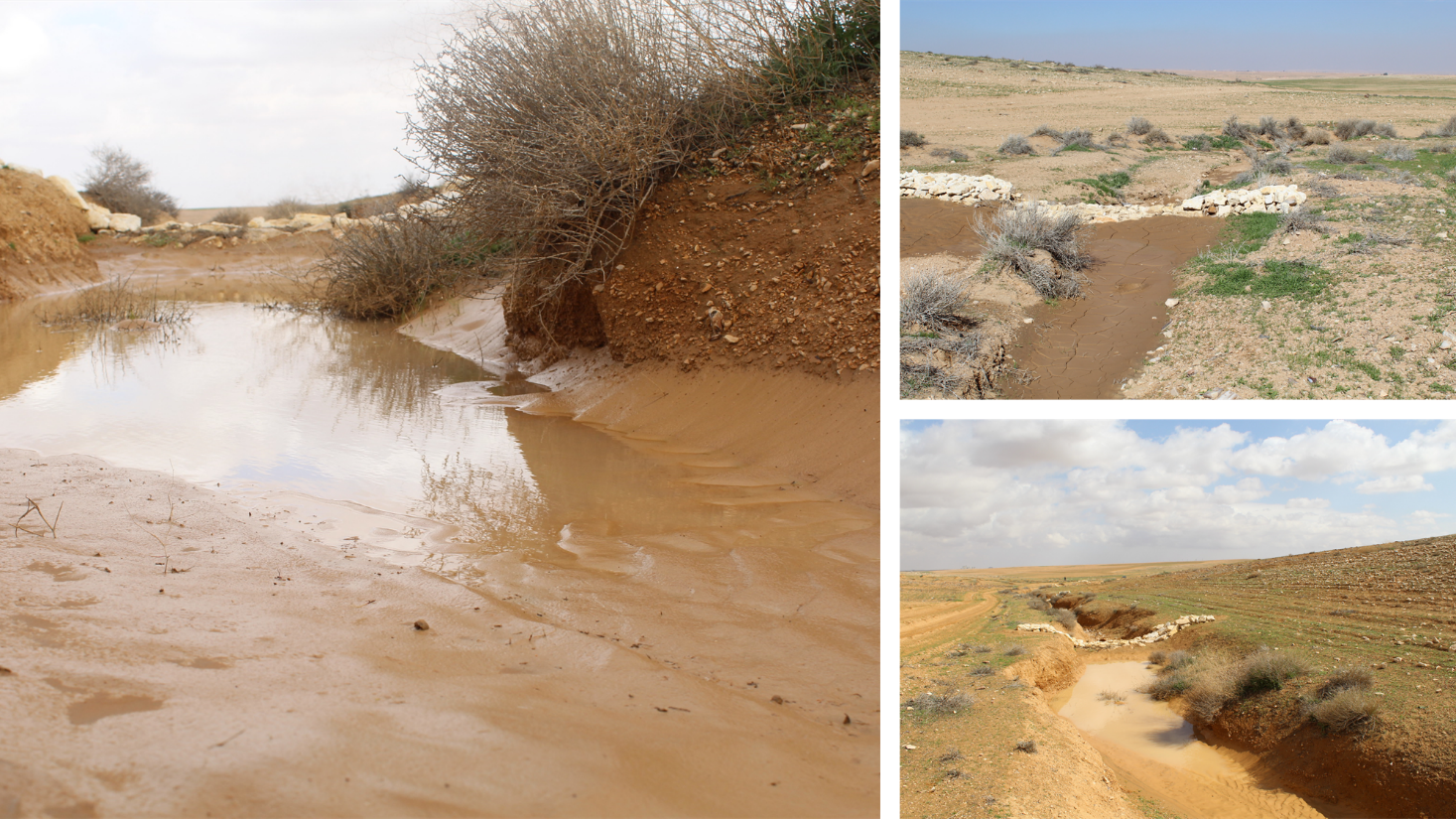
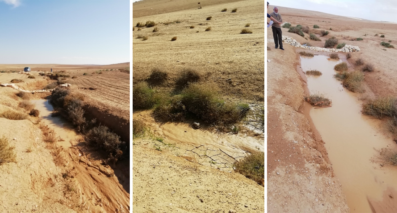
Gully plugs aim at rehabilitating active gullies in dryland watersheds, which are prone to erosion through concentrated surface runoff. Multiple gullies plugged in succession dissipate runoff energy, foster local water retention and infiltration, encourage sedimentation, assist in the stabilization of gully bed and side banks, and stimulate revegetation of flow paths; the channel measures must be combined with proper SLM in the catchments upstream.
2.2 การอธิบายแบบละเอียดของเทคโนโลยี
คำอธิบาย:
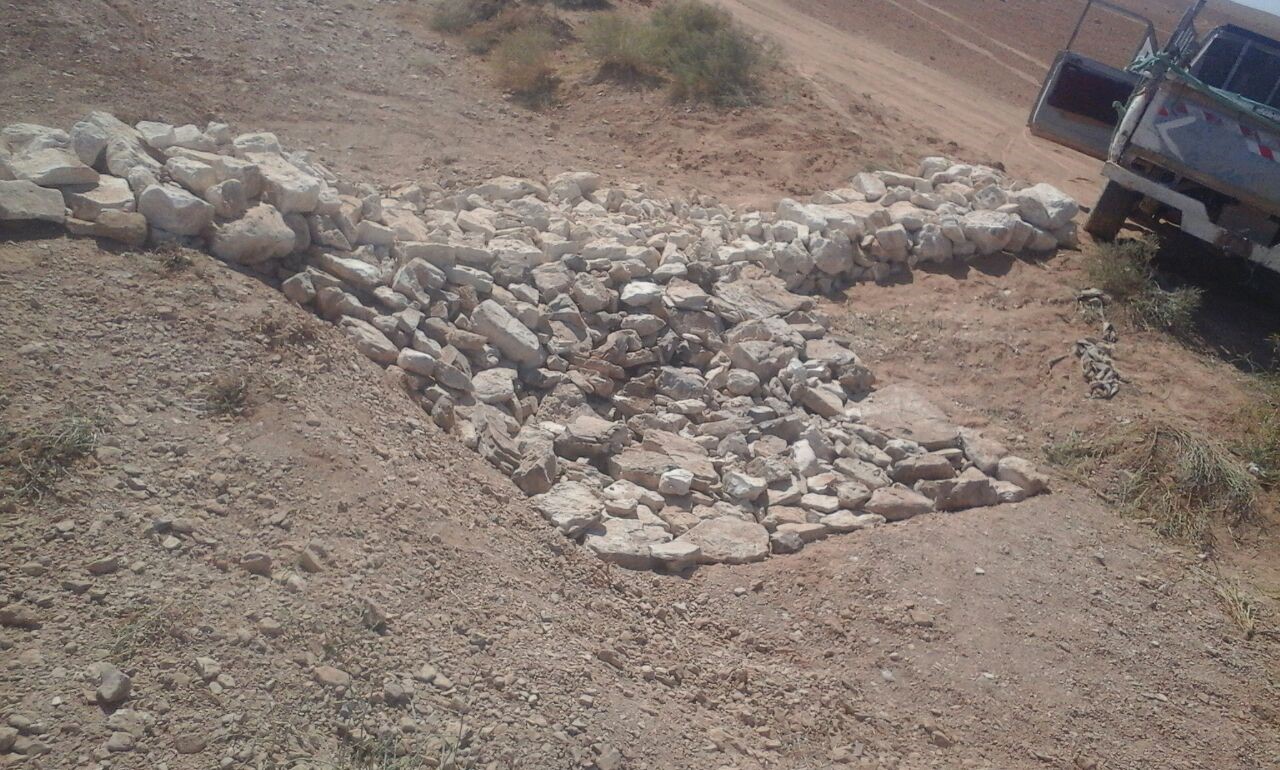
Characteristics: Multiple gully plugs positioned sequentially within a gully system interrupt concentrated surface runoff and reduce its erosive power. The plugs are each made of multiple cobbles/stones mostly ranging between 10 and 30 cm diameter and constructed to ensure a stable structure. The plugs started at the head of the gully (upstream) and ranges from 1.5 - 3.7 m in width with an average of 2.5 m. For heavily eroded and very unstable sections, gabions can be used also. The structures are around 1.0 to 1.5-m high, anchored into the sidewalls, and around 0.20 to 0.35 m deep into the gully bed, built up to around 1/3 to max. 1/2 of the gully depth - ensuring the concentrated flow stays within the channel and does not overflow the side banks. The top of the plug is U-shaped, with the sides built higher than the centre. Upslope, the plugs are packed with soil to trap sediments (stopping it flowing through the structure), and downslope the plugs have an apron to dissipate the energy of overflowing water, into a micro stilling basin. The downslope side of the gully plug is sloped rather than vertical. The large stones add roughness to the slope, creating a rough spillway that dissipates erosive energy. In the direction of gully flow, several gully plugs are placed such that the upper gully apron is set at approximately the height of the following downstream gully crest.
Environment: The technology is used in a watershed close to Al Majeddyeh village, located in the Middle Badia zone, approximately 30 km south-east of Amman. The climate is arid and warm (Palmer, 2013). The average annual rainfall is around 130 mm. The natural environment is labelled as steppe, “BSh” in the köppen classification. The human environment is characterized by agropastoralists. They are semi-nomadic and live in villages around the watershed, for example, Al Majeddyeh village.
Purpose: The measure interrupts the concentrated flow, reduces velocity, and dissipates energy. Multiple structures along the gully decrease the erosive power of runoff, retaining a fraction of the runoff, inducing sedimentation (upstream of the plug), thus protecting the gully bed from further deep-scouring, and strengthening the gully side banks, especially when this is linked with re-vegetation. Over time, the establishing vegetation (roots and surface cover) stabilizes the soil and protects it from concentrated flow erosion. To be effective, gully plug emplacement requires SLM in upland areas. These measures then jointly mitigate peak runoff generation and accordingly reduce downstream flooding.
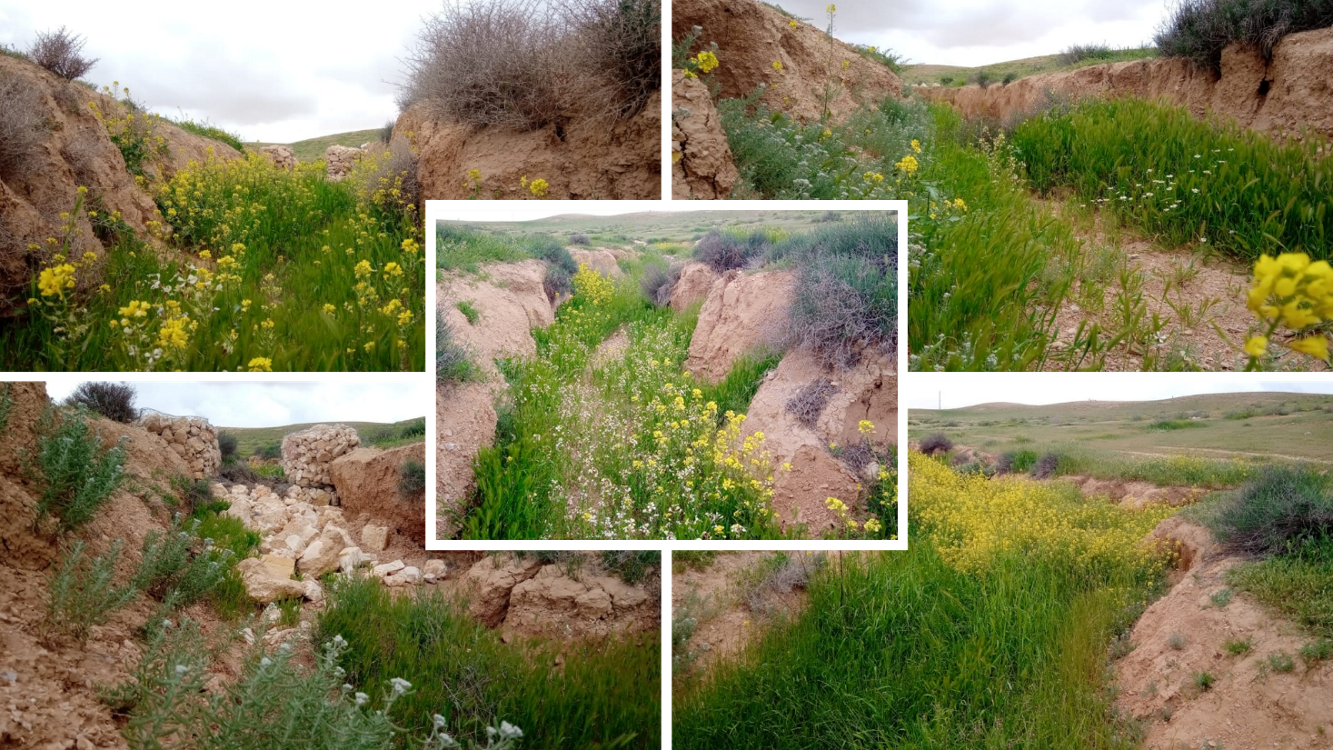
Major activities: Upland SLM is essential. In the specific watershed rehabilitation context, upland SLM was achieved through micro water harvesting and re-vegetation through native shrubs (the “VALLERANI” method). Gully morphology assessment is required for gully plug design, and positioning and earthwork excavation is necessary for foundation preparation in the gully bed and wall anchors. Proper layering of various size stones and shaping of gully plugs is necessary as is the addition of a packed soil pack upstream of the stone structure, to semi-seal the surface and to pond water. Then gully walls are revegetated through native seedlings: these benefit from the water ponding upstream prior to sedimentation upstream of the gully and enhanced soil water storage in the sediments once the gully is filled.
Benefits: Stops ongoing land degradation and gully deepening, and achieves a certain degree of rehabilitation; retains a fraction of runoff water and sediments in the watershed – water mainly infiltrates and provides moisture to the gully vegetation; gully vegetation serves various purposes including livestock fodder, reduction of flow velocities in the gully, and retention of further sediment.
Land user's opinion: Land users benefit from the vegetation (e.g. fruit trees can potentially be out-planted), as well as ponded water for livestock; however, the technology is labor-intensive, and therefore costly, and landowners (at the local target site) require incentives to carry out the work.
2.3 รูปภาพของเทคโนโลยี
อัลบั้มสื่อบันทึก
2.5 ประเทศภูมิภาค หรือสถานที่ตั้งที่เทคโนโลยีได้นำไปใช้และได้รับการครอบคลุมโดยการประเมินนี้
ประเทศ:
จอร์แดน
ภูมิภาค/รัฐ/จังหวัด:
Amman governorate/Al Jizza/Al Majeddyeh village
ระบุการกระจายตัวของเทคโนโลยี:
- ใช้ ณ จุดที่เฉพาะเจาะจงหรือเน้นไปยังบริเวณพื้นที่ขนาดเล็ก
Is/are the technology site(s) located in a permanently protected area?
ไม่ใช่
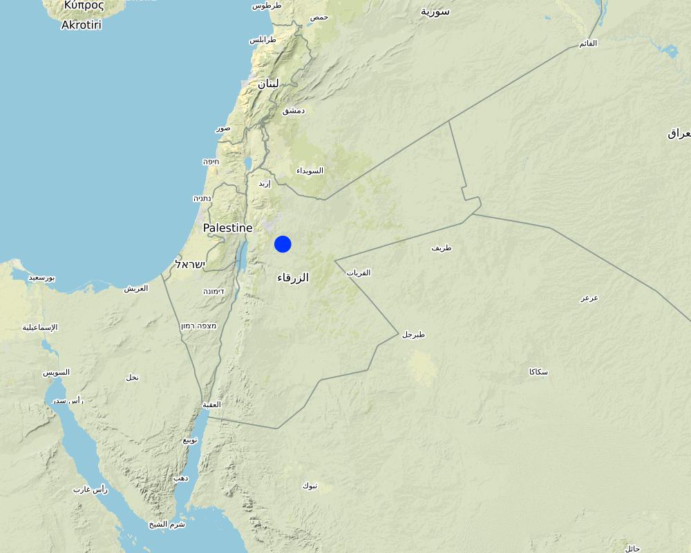
Map
×2.6 วันที่การดำเนินการ
ระบุปีที่ใช้:
2017
2.7 คำแนะนำของเทคโนโลยี
ให้ระบุว่าเทคโนโลยีถูกแนะนำเข้ามาอย่างไร:
- ในช่วงการทดลองหรือการทำวิจัย
- ทางโครงการหรือจากภายนอก
3. การจัดประเภทของเทคโนโลยี SLM
3.1 วัตถุประสงค์หลักของเทคโนโลยี
- ลด ป้องกัน ฟื้นฟู การเสื่อมโทรมของที่ดิน
- รักษาสภาพหรือปรับปรุงความหลากหลายทางชีวภาพ
- ลดความเสี่ยงของภัยพิบัติ
3.2 ประเภทของการใช้ที่ดินในปัจจุบันที่ได้นำเทคโนโลยีไปใช้
Land use mixed within the same land unit:
ใช่
Specify mixed land use (crops/ grazing/ trees):
- Agro-pastoralism (incl. integrated crop-livestock)

ทุ่งหญ้าเลี้ยงสัตว์
Extensive grazing:
- กึ่งโนแมนดิซึ่มหรือแพสโตแรลลิซึ่ม (Semi-nomadism/pastoralism)

ทางน้ำ แหล่งน้ำ พื้นที่ชุ่มน้ำ
- ทางระบายน้ำ ทางน้ำ
ผลิตภัณฑ์หลักหรือบริการ:
To convey and drain: Wd
3.3 Has land use changed due to the implementation of the Technology?
Has land use changed due to the implementation of the Technology?
- Yes (Please fill out the questions below with regard to the land use before implementation of the Technology)
Land use mixed within the same land unit:
ไม่ใช่
ทุ่งหญ้าเลี้ยงสัตว์
Extensive grazing:
- การเลี้ยงสัตว์แบบเร่ร่อนไปตามที่ต่าง ๆ (Nomadism)
- กึ่งโนแมนดิซึ่มหรือแพสโตแรลลิซึ่ม (Semi-nomadism/pastoralism)
Animal type:
- goats
- sheep
Is integrated crop-livestock management practiced?
ไม่ใช่
ผลิตภัณฑ์และบริการ:
- meat
3.4 การใช้น้ำ
การใช้น้ำของที่ดินที่มีการใช้เทคโนโลยีอยู่:
- จากน้ำฝน
แสดงความคิดเห็น:
The measure mitigates the effect of surface runoff in concentrated flow areas - as a consequence of heavy rainfall events
3.5 กลุ่ม SLM ที่ตรงกับเทคโนโลยีนี้
- การปรับปรุงดิน / พืชคลุมดิน
- การรบกวนดินให้น้อยที่สุด
- มาตรการปลูกพืชขวางความลาดชัน (cross-slope measure)
- water harvesting; surface water management (spring, river, lakes, sea, riparian zone, riverbanks, seashore, lakeshore, spring shed); ecosystem-based disaster risk reduction
3.6 มาตรการ SLM ที่ประกอบกันเป็นเทคโนโลยี

มาตรการอนุรักษ์ด้วยวิธีพืช
- V2: หญ้าและไม้ยืนต้น

มาตรการอนุรักษ์ด้วยโครงสร้าง
- S6: กำแพง สิ่งกีดขวาง รั้วไม้ รั้วต่างๆ

มาตรการอื่น ๆ
ระบุ:
Specify tillage system: no tillage
Specify residue management: grazed and retained
3.7 รูปแบบหลักของการเสื่อมโทรมของที่ดินที่ได้รับการแก้ไขโดยเทคโนโลยี

การกัดกร่อนของดินโดยน้ำ
- Wg (Gully erosion): การกัดกร่อนแบบร่องธารหรือการทำให้เกิดร่องน้ำเซาะ
- Wo (Offsite degradation): ผลกระทบนอกพื้นที่

การเสื่อมโทรมของดินทางด้านกายภาพ
- Pk (Slaking and crusting): การอุดตันของช่องว่างในดินหรือรูพรุน
- Pu (Loss of bio-productive function): การสูญเสียหน้าที่การผลิตทางชีวภาพอันเนื่องมาจากกิจกรรม อื่นๆ

การเสื่อมโทรมของน้ำ
- Hs (Change in quantity of surface water): การเปลี่ยนแปลงปริมาณของน้ำที่ผิวดิน
- Hw (Reduction of the buffering capacity of wetland): การลดลงของความทนทานต่อการเปลี่ยนแปลง ของพื้นที่ชุ่มน้ำ
3.8 การป้องกัน การลดลง หรือการฟื้นฟูความเสื่อมโทรมของที่ดิน
ระบุเป้าหมายของเทคโนโลยีกับความเสื่อมโทรมของที่ดิน:
- ลดความเสื่อมโทรมของดิน
- ฟื้นฟูบำบัดที่ดินที่เสื่อมโทรมลงอย่างมาก
4. ข้อมูลจำเพาะด้านเทคนิค กิจกรรมการนำไปปฏิบัติใช้ ปัจจัยนำเข้า และค่าใช้จ่าย
4.1 แบบแปลนทางเทคนิคของเทคโนโลยี
ข้อมูลจำเพาะด้านเทคนิค (แบบแปลนทางเทคนิคของเทคโนโลยี):
Emplacement in gully morphological system and watershed context: Determine the downstream starting point for the gully plugs and then extend upstream. The basic design is to keep the structure height maximum half the gully depth regardless of structure type. The spacing between structures is set as a gully depth function, structure crest height above the gully bed, and slope of the gully bed between structures. Additionally, the structure's final location will be shifted either upstream or downstream of the calculated gully bed level to place the structure in a more stable point if required. Following this methodology ensures variable spacing between structures to cope with both slope and depth of gully to ensure the sediment filling in between these structures occurs. In the case of distinct gully morphology and side banks that are very unstable, gabion structures can also be used/instead of a single stone pack.
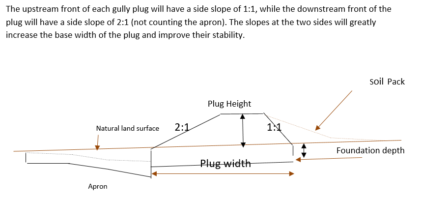
Design of the Structure: Gully plugs must be anchored strong enough to resist water flow and prevent bypass from the side banks. A foundation is also required for all structures, depending on their dimensions and the bed's nature. At the specific site, the foundation depth for the planned structures ranges between 0.2 to 0.35 meters. The anchoring of gully plugs ranges between 1 and 1.5 meters. This depends on the existing condition of the banks at each structure location. Gully plugs have a downstream apron with a length of around 3 to 4 times the height of structures. The apron starts from below the bottom level of the foundation and gradually level halfway down. All gully plugs were designed to have a height maximum of 0.5 the depth of the gully. So each structure will pass water flow downward but keeping it inside the gully. Gabion structures have a sort of spillway from the top but at the same time protecting the banks. The configuration slightly differs from the normal stone structure, but the idea is to protect the sides and a spillway in the middle. The upstream front of each gully plug has a side slope of 1:1, while the downstream front of the plug has a side slope of 2:1 (not counting the apron). The slopes at the two sides greatly increase the base width of the plug and improve their stability. The gully plugs are provided with an amount of soil resulting from the foundation to form a triangle of soil fill against the structure at the upstream side; this improves the function of the gully plugin holding more water and trapping sediments. On the other side of each structure, the downstream side's slope is meant to tackle the overflow of water along the drop to safely return to the gully bed level without causing additional erosion. The rock-filled apron catches the flow and acts to dissipate erosive energy.
ผู้เขียน:
Steve Evett
วันที่:
15/08/2017
4.2 ข้อมูลทั่วไปเกี่ยวกับการคำนวณปัจจัยนำเข้าและค่าใช้จ่าย
ให้ระบุว่าค่าใช้จ่ายและปัจจัยนำเข้าได้รับการคำนวณอย่างไร:
- ต่อหน่วยเทคโนโลยี
โปรดระบุหน่วย:
Gully plug
ระบุสกุลเงินที่ใช้คำนวณค่าใช้จ่าย:
- USD
4.3 กิจกรรมเพื่อการจัดตั้ง
| กิจกรรม | Timing (season) | |
|---|---|---|
| 1. | Implement upland watershed SLM (reference VALLERANI) | |
| 2. | Gully system/morphological assessment | |
| 3. | Determine plug design and implementation in the watershed | |
| 4. | Excavation earthworks for anchors and foundation | At least 2 months prior rainy season onset |
| 5. | Stone made construction of gully plugs (occasionally with gabions) | At least 1 month prior rainy season onset |
| 6. | Soil pack at upstream front | At least 1 month prior rainy season onset |
| 7. | Revegetation of gully side banks | At the onset of the rainy season |
แสดงความคิดเห็น:
Gully plugs require proper SLM in the uplands. Revegetation of gully side banks is optional – depending on the recovery potential of the area.
4.4 ค่าใช้จ่ายของปัจจัยนำเข้าที่จำเป็นสำหรับการจัดตั้ง
| ปัจจัยนำเข้า | หน่วย | ปริมาณ | ค่าใช้จ่ายต่อหน่วย | ค่าใช้จ่ายทั้งหมดต่อปัจจัยนำเข้า | %ของค่าใช้จ่ายที่ก่อให้เกิดขึ้นโดยผู้ใช้ที่ดิน | |
|---|---|---|---|---|---|---|
| แรงงาน | Field technician (design and oversight) | Labour Day (LD) per structure | 0.2 | 50.0 | 10.0 | |
| แรงงาน | Workers (excavation/earthworks) | LD | 4.0 | 35.0 | 140.0 | |
| แรงงาน | Workers (stone layering/construction) | LD | 4.0 | 35.0 | 140.0 | |
| แรงงาน | Worker (out-planting of seedlings) | LD | 1.0 | 35.0 | 35.0 | |
| อุปกรณ์ | Shovel, Pickaxe, buckets, ruler | Lump sum | 1.0 | 10.0 | 10.0 | |
| วัสดุด้านพืช | Seedlings | per item | 10.0 | 0.5 | 5.0 | |
| วัสดุสำหรับก่อสร้าง | Stones | m3 | 4.0 | 10.0 | 40.0 | |
| อื่น ๆ | Logistics (seedling transport, local stone transport) | lump sum | 1.0 | 10.0 | 10.0 | |
| ค่าใช้จ่ายทั้งหมดของการจัดตั้งเทคโนโลยี | 390.0 | |||||
| Total costs for establishment of the Technology in USD | 390.0 | |||||
ถ้าผู้ใช้ที่ดินรับภาระน้อยกว่า 100% ของค่าใช้จ่าย ให้ระบุว่าใครเป็นผู้รับผิดชอบส่วนที่เหลือ:
International research for the development project.
แสดงความคิดเห็น:
Design is tailored for implementation through local workers (rural agro-pastoral community) and local materials. The engagement of local community workers as part of the specific project; if a professional contractor is hired costs can be significantly reduced.
4.5 การบำรุงรักษาสภาพหรือกิจกรรมที่เกิดขึ้นเป็นประจำ
| กิจกรรม | ช่วงระยะเวลา/ความถี่ | |
|---|---|---|
| 1. | Inspect damage/status | After severe storms and runoff events |
| 2. | Maintain/repair/improve | After inspection |
แสดงความคิดเห็น:
If optimally designed and connected with proper upland SLM the gully plug technology would not require maintenance; the measure induces nature-based (vegetation) protection of vulnerable gully zones over time.
4.6 ค่าใช้จ่ายของปัจจัยนำเข้าและกิจกรรมที่เกิดขึ้นเป็นประจำที่ต้องการการบำรุงรักษา (ต่อปี)
| ปัจจัยนำเข้า | หน่วย | ปริมาณ | ค่าใช้จ่ายต่อหน่วย | ค่าใช้จ่ายทั้งหมดต่อปัจจัยนำเข้า | %ของค่าใช้จ่ายที่ก่อให้เกิดขึ้นโดยผู้ใช้ที่ดิน | |
|---|---|---|---|---|---|---|
| แรงงาน | Expert (investigation) | LD | 0.1 | 50.0 | 5.0 | |
| แรงงาน | LD | 0.5 | 35.0 | 17.5 | ||
| แรงงาน | LD | 1.0 | 35.0 | 35.0 | ||
| วัสดุสำหรับก่อสร้าง | stones | m3 | 0.5 | 10.0 | 5.0 | |
| ค่าใช้จ่ายทั้งหมดของการบำรุงรักษาสภาพเทคโนโลยี | 62.5 | |||||
| Total costs for maintenance of the Technology in USD | 62.5 | |||||
ถ้าผู้ใช้ที่ดินรับภาระน้อยกว่า 100% ของค่าใช้จ่าย ให้ระบุว่าใครเป็นผู้รับผิดชอบส่วนที่เหลือ:
It is 100% covered by the research project
แสดงความคิดเห็น:
Maintenance might be needed in case of improper implementation and/or extreme event occurrence. Maintenance should be minimal - mostly after initial 1-2 rainy seasons. Thereafter, revegetated and rehabilitated gully system – and most importantly, the rehabilitated uplands - would take on hydrological buffering functions and withstand the erosive force of surface runoff.
4.7 ปัจจัยสำคัญที่สุดที่มีผลกระทบต่อค่าใช้จ่าย
ปัจจัยสำคัญที่สุดที่มีผลกระทบต่อค่าใช้จ่ายต่างๆ:
The most distinct cost factor is labor – which is especially significant when using local (community) labor; some technical training is required.
5. สิ่งแวดล้อมทางธรรมชาติและของมนุษย์
5.1 ภูมิอากาศ
ฝนประจำปี
- < 250 ม.ม.
- 251-500 ม.ม.
- 501-750 ม.ม.
- 751-1,000 ม.ม.
- 1,001-1,500 ม.ม.
- 1,501-2,000 ม.ม.
- 2,001-3,000 ม.ม.
- 3,001-4,000 ม.ม.
- > 4,000 ม.ม.
ระบุปริมาณน้ำฝนเฉลี่ยรายปี (ถ้ารู้) :หน่วย ม.ม.
130.00
ข้อมูลจำเพาะ/ความคิดเห็นเรื่องปริมาณน้ำฝน:
Jordan has a rainy season from September to May – but locally, the effective rainy season sets on later (November or December) and lasts until April.
ระบุชื่อของสถานีตรวดวัดอากาศที่ใช้อ้างอิงคือ:
Queen Alia international airport reference station reports long term average annual rainfall of about 150 mm A rainfall tipping bucket installed in the site in 2016.
เขตภูมิอากาศเกษตร
- แห้งแล้ง
5.2 สภาพภูมิประเทศ
ค่าเฉลี่ยความลาดชัน:
- ราบเรียบ (0-2%)
- ลาดที่ไม่ชัน (3-5%)
- ปานกลาง (6-10%)
- เป็นลูกคลื่น (11-15%)
- เป็นเนิน (16-30%)
- ชัน (31-60%)
- ชันมาก (>60%)
ธรณีสัณฐาน:
- ที่ราบสูง/ที่ราบ
- สันเขา
- ไหล่เขา
- ไหล่เนินเขา
- ตีนเนิน
- หุบเขา
ระดับความสูง:
- 0-100 เมตร
- 101-500 เมตร
- 501-1,000 เมตร
- 1,001-1,500 เมตร
- 1,501-2,000 เมตร
- 2,001-2,500 เมตร
- 2,501-3,000 เมตร
- 3,001-4,000 เมตร
- > 4,000 เมตร
ให้ระบุถ้าเทคโนโลยีได้ถูกนำไปใช้:
- บริเวณแอ่งบนที่ราบ (concave situations)
ความคิดเห็นและข้อมูลจำเพาะเพิ่มเติมเรื่องสภาพภูมิประเทศ:
Gully slope is 3.4% on average.
5.3 ดิน
ค่าเฉลี่ยความลึกของดิน:
- ตื้นมาก (0-20 ซ.ม.)
- ตื้น (21-50 ซ.ม.)
- ลึกปานกลาง (51-80 ซ.ม.)
- ลึก (81-120 ซ.ม.)
- ลึกมาก (>120 ซ.ม.)
เนื้อดิน (ดินชั้นบน):
- ปานกลาง (ดินร่วน ทรายแป้ง)
- ละเอียด/หนัก (ดินเหนียว)
เนื้อดินล่าง (> 20 ซ.ม.ต่ำจากผิวดิน):
- ปานกลาง (ดินร่วน ทรายแป้ง)
- ละเอียด/หนัก (ดินเหนียว)
อินทรียวัตถุในดิน:
- ต่ำ (<1%)
(ถ้ามี) ให้แนบคำอธิบายเรื่องดินแบบเต็มหรือระบุข้อมูลที่มีอยู่ เช่น ชนิดของดิน ค่า pH ของดินหรือความเป็นกรดของดิน ความสามารถในการแลกเปลี่ยนประจุบวก ไนโตรเจน ความเค็ม เป็นต้น:
Soil depth is varying throughout the gully areas. At some points (mostly upstream) the gully bed reaches the bedrock
5.4 ความเป็นประโยชน์และคุณภาพของน้ำ
ระดับน้ำใต้ดิน:
> 50 เมตร
น้ำไหลบ่าที่ผิวดิน:
ปานกลาง
คุณภาพน้ำ (ที่ยังไม่ได้บำบัด):
เป็นน้ำใช้เพื่อการเกษตรเท่านั้น (การชลประทาน)
Water quality refers to:
surface water
ความเค็มของน้ำเป็นปัญหาหรือไม่:
ไม่ใช่
กำลังเกิดน้ำท่วมในพื้นที่หรือไม่:
ใช่
บ่อยครั้ง:
บ่อยครั้ง
5.5 ความหลากหลายทางชีวภาพ
ความหลากหลายทางชนิดพันธุ์:
- สูง
ความหลากหลายของแหล่งที่อยู่:
- ปานกลาง
ความคิดเห็นและข้อมูลจำเพาะเพิ่มเติมของความหลากหลายทางชีวภาพ:
Gully plugs with out-planted vegetation create micro-climates; after recruitment and emergence of seed material, biodiversity increases.
5.6 ลักษณะของผู้ใช้ที่ดินที่นำเทคโนโลยีไปปฏิบัติใช้
อยู่กับที่หรือเร่ร่อน:
- อยู่กับที่
- กึ่งเร่ร่อน
รายได้ที่มาจากนอกฟาร์ม:
- < 10% ของรายได้ทั้งหมด
ระดับของความมั่งคั่งโดยเปรียบเทียบ:
- ยากจนมาก
- จน
เป็นรายบุคคล/ครัวเรือน:
- เป็นรายบุคคล/ครัวเรือน
- กลุ่ม/ชุมชน
ระดับของการใช้เครื่องจักรกล:
- งานที่ใช้แรงกาย
เพศ:
- ชาย
อายุของผู้ใช้ที่ดิน:
- ผู้เยาว์
- วัยกลางคน
5.7 Average area of land used by land users applying the Technology
- < 0.5 เฮกตาร์
- 0.5-1 เฮกตาร์
- 1-2 เฮกตาร์
- 2-5 เฮกตาร์
- 5-15 เฮกตาร์
- 15-50 เฮกตาร์
- 50-100 เฮกตาร์
- 100-500 เฮกตาร์
- 500-1,000 เฮกตาร์
- 1,000-10,000 เฮกตาร์
- >10,000 เฮกตาร์
พิจารณาว่าเป็นขนาดเล็ก กลาง หรือขนาดใหญ่ (ซึ่งอ้างอิงถึงบริบทระดับท้องถิ่น):
- ขนาดใหญ่
แสดงความคิดเห็น:
The entire watershed area affected by gully plugs is 160 hectares.
The total constructed plugs are 55.
5.8 กรรมสิทธิ์ในที่ดิน สิทธิในการใช้ที่ดินและสิทธิในการใช้น้ำ
กรรมสิทธิ์ในที่ดิน:
- รายบุคคล ได้รับสิทธิครอบครอง
สิทธิในการใช้ที่ดิน:
- รายบุคคล
Are land use rights based on a traditional legal system?
ใช่
5.9 การเข้าถึงบริการและโครงสร้างพื้นฐาน
สุขภาพ:
- จน
- ปานกลาง
- ดี
การศึกษา:
- จน
- ปานกลาง
- ดี
ความช่วยเหลือทางด้านเทคนิค:
- จน
- ปานกลาง
- ดี
การจ้างงาน (เช่น ภายนอกฟาร์ม):
- จน
- ปานกลาง
- ดี
ตลาด:
- จน
- ปานกลาง
- ดี
พลังงาน:
- จน
- ปานกลาง
- ดี
ถนนและการขนส่ง:
- จน
- ปานกลาง
- ดี
น้ำดื่มและการสุขาภิบาล:
- จน
- ปานกลาง
- ดี
บริการด้านการเงิน:
- จน
- ปานกลาง
- ดี
6. ผลกระทบและสรุปคำบอกกล่าว
6.1 ผลกระทบในพื้นที่ดำเนินการ (On-site) จากการใช้เทคโนโลยี
ผลกระทบทางด้านเศรษฐกิจและสังคม
การผลิต
การผลิตพืชที่ใช้เลี้ยงปศุสัตว์
คุณภาพพืชที่ใช้เลี้ยงปศุสัตว์
ความเป็นประโยชน์และคุณภาพของน้ำ
การมีน้ำไว้ให้ปศุสัตว์
ผลกระทบด้านสังคมวัฒนธรรมอื่น ๆ
ความมั่นคงด้านอาหาร / พึ่งตนเองได้
แสดงความคิดเห็น/ระบุ:
Some herbs (and fruits (trees) in the future)
โอกาสทางด้านสันทนาการ
แสดงความคิดเห็น/ระบุ:
enhanced biodiversity, shade and shelter
SLM หรือความรู้เรื่องความเสื่อมโทรมของที่ดิน
แสดงความคิดเห็น/ระบุ:
Through training/community participation
ผลกระทบด้านนิเวศวิทยา
วัฐจักรน้ำหรือน้ำบ่า
คุณภาพน้ำ
แสดงความคิดเห็น/ระบุ:
Certain degree purification through infiltration in the sediment accumulation zone
การเก็บเกี่ยวหรือการกักเก็บน้ำ
น้ำไหลบ่าที่ผิวดิน
แสดงความคิดเห็น/ระบุ:
Effect on hydrology (distinctness of runoff peak)
น้ำบาดาลหรือระดับน้ำในแอ่งน้ำบาดาล
แสดงความคิดเห็น/ระบุ:
Certain deep-infiltration
การระเหย
แสดงความคิดเห็น/ระบุ:
more open water ponding – but also deep-infiltration and beneficial use for vegetation (transpiration)
ดิน
ความชื้นในดิน
สิ่งปกคลุมดิน
การสูญเสียดิน
แสดงความคิดเห็น/ระบุ:
Side banks stabilized
การสะสมของดิน
แสดงความคิดเห็น/ระบุ:
sediments trapped
การเกิดแผ่นแข็งที่ผิวดิน /การเกิดชั้นดาน
แสดงความคิดเห็น/ระบุ:
sediment crust increased in the ponding area – but better soil structure at the side banks (revegetation) – overall positive impact.
ความหลากหลายทางชีวภาพของพืชและสัตว์
การปกคลุมด้วยพืช
มวลชีวภาพ/เหนือดินชั้น C
ความหลากหลายทางชีวภาพของพืช
ความหลากหลายทางชีวภาพของสัตว์
ชนิดพันธุ์ที่ให้ประโยชน์
ลดความเสี่ยงของภัยพิบัติ
ผลกระทบจากน้ำท่วม
ดินถล่ม/ ซากต่าง ๆ ที่ถูกพัดพามา
แสดงความคิดเห็น/ระบุ:
Through side bank stabilization.
ภูมิอากาศจุลภาค
6.2 ผลกระทบนอกพื้นที่ดำเนินการ (Off-site) จากการใช้เทคโนโลยี
น้ำท่วมพื้นที่ท้ายน้ำ
การทับถมของดินตะกอนพื้นที่ท้ายน้ำ
แสดงความคิดเห็น/ระบุ:
especially when combined with upland measure: reference VALLERANI
ความเสียหายต่อพื้นที่เพาะปลูกของเพื่อนบ้าน
แสดงความคิดเห็น/ระบุ:
Less tributary channel development (connectivity of upland areas); less downstream siltation
ความเสียหายต่อโครงสร้างพื้นฐานของรัฐหรือของเอกชน
แสดงความคิดเห็น/ระบุ:
less runoff peakiness and siltation
6.3 การเผชิญและความตอบสนองของเทคโนโลยีต่อการเปลี่ยนแปลงสภาพภูมิอากาศที่ค่อยเป็นค่อยไป และสภาพรุนแรงของภูมิอากาศ / ภัยพิบัติ (ที่รับรู้ได้โดยผู้ใช้ที่ดิน)
การเปลี่ยนแปลงสภาพภูมิอากาศที่ค่อยเป็นค่อยไป
การเปลี่ยนแปลงสภาพภูมิอากาศที่ค่อยเป็นค่อยไป
| ฤดู | increase or decrease | เทคโนโลยีมีวิธีการรับมืออย่างไร | |
|---|---|---|---|
| อุณหภูมิประจำปี | เพิ่มขึ้น | ปานกลาง | |
| ฝนประจำปี | ลดลง | ดี |
สภาพรุนแรงของภูมิอากาศ (ภัยพิบัติ)
ภัยพิบัติทางอุตุนิยมวิทยา
| เทคโนโลยีมีวิธีการรับมืออย่างไร | |
|---|---|
| พายุฝนประจำท้องถิ่น | ดี |
ภัยพิบัติจากน้ำ
| เทคโนโลยีมีวิธีการรับมืออย่างไร | |
|---|---|
| น้ำท่วมฉับพลัน | ดีมาก |
ภัยพิบัติทางชีวภาพ
| เทคโนโลยีมีวิธีการรับมืออย่างไร | |
|---|---|
| โรคระบาด | ดี |
ผลลัพธ์ตามมาที่เกี่ยวข้องกับภูมิอากาศอื่น ๆ
ผลลัพธ์ตามมาที่เกี่ยวข้องกับภูมิอากาศอื่น ๆ
| เทคโนโลยีมีวิธีการรับมืออย่างไร | |
|---|---|
| ช่วงการปลูกพืชที่ขยายออกไป | ดีมาก |
6.4 การวิเคราะห์ค่าใช้จ่ายและผลประโยชน์ที่ได้รับ
ผลประโยชน์ที่ได้รับเปรียบเทียบกับค่าใช้จ่ายในการจัดตั้งเป็นอย่างไร (จากมุมมองของผู้ใช้ที่ดิน)
ผลตอบแทนระยะสั้น:
ด้านลบ
ผลตอบแทนระยะยาว:
ด้านบวก
ผลประโยชน์ที่ได้รับเปรียบเทียบกับค่าใช้จ่ายในการบำรุงรักษาหรือต้นทุนที่เกิดขึ้นซ้ำอีก เป็นอย่างไร (จากมุมมองของผู้ใช้ที่ดิน)
ผลตอบแทนระยะสั้น:
ด้านลบ
ผลตอบแทนระยะยาว:
ด้านบวกเล็กน้อย
แสดงความคิดเห็น:
During the initial stage potential benefits through vegetation do not materialize; main effects are on water and sediment retention. Long-term, the technology fosters the rehabilitation nature-based retention functions (very limited long-term maintenance required).
6.5 การปรับตัวของเทคโนโลยี
- ครั้งเดียวหรือเป็นการทดลอง
ถ้ามีข้อมูลให้บอกปริมาณด้วย (จำนวนของครัวเรือนหรือครอบคลุมพื้นที่):
1
Of all those who have adopted the Technology, how many did so spontaneously, i.e. without receiving any material incentives/ payments?
- 0-10%
6.6 การปรับตัว
เทคโนโลยีได้รับการปรับเปลี่ยนเมื่อเร็วๆนี้ เพื่อให้ปรับตัวเข้ากับสภาพที่กำลังเปลี่ยนแปลงหรือไม่:
ไม่ใช่
6.7 จุดแข็ง / ข้อได้เปรียบ / โอกาสของเทคโนโลยี
| จุดแข็ง / ข้อได้เปรียบ / โอกาสในทัศนคติของผู้ใช้ที่ดิน |
|---|
| Gully side bank vegetation useable as (livestock) fodder source; some herbs (later fruit tree benefits) for human consumption. |
| Gully is stable and does not expand e.g. tributaries. Uplands remain connected and productive. |
| Ponded water for livestock watering (during the rainy season). |
| Shelter and shade through vegetation. |
| จุดแข็ง / ข้อได้เปรียบ / โอกาสในทัศนคติของผู้รวบรวมหรือวิทยากรหลัก |
|---|
| Sediments from the uplands are trapped; relatively fertile soil remains in the watershed. |
| Increased local soil moisture and consequential vegetation quantity and bio-diversity enhancement; increase carbon storage and other ecosystem services such as pollination. |
| Smoothened watershed hydrology is beneficial for downstream agriculture – especially when applied in a watershed context with downstream flood irrigation (MARAB) |
| Protection of downstream infrastructure (flooding and sediments). |
6.8 จุดอ่อน / ข้อเสียเปรียบ / ความเสี่ยงของเทคโนโลยีและวิธีการแก้ไข
| จุดอ่อน / ข้อเสียเปรียบ / ความเสี่ยงในทัศนคติของผู้ใช้ที่ดิน | มีวิธีการแก้ไขได้อย่างไร |
|---|---|
| implementation costs | Incentives (e.g. governmental) for communities to implement SLM; regulations and enforcement on environmental management – especially connected with entitlements of natural resources facilitation |
| Tensions between upstream and downstream watershed users (watershed hydrology) – especially affected through wrong design and failure (e.g. gully breakage) | Community-based and holistic watershed management – the share of benefits and commitment for maintenance. |
| Additional fodder supply might attract other foreign herders (overgrazing) | Community-based and holistic watershed management – and protection. |
| Technical skills needed for implementation | Rural communities’ capacity building programs |
| จุดอ่อน / ข้อเสียเปรียบ / ความเสี่ยงในทัศนคติของผู้รวบรวมหรือวิทยากรหลัก | มีวิธีการแก้ไขได้อย่างไร |
|---|---|
| Expert design and implementation support required | Governmental and environmental organizations in control of design and support to local communities (training). |
| Requires upland SLM | Integrated watershed management and empowerment of local communities to manage and facilitate – provision of support (e.g. government and/or international projects). |
| Increased vegetation in a fragile ecosystem can lead to local pressure | Integrated watershed management and empowerment of local communities – especially sustainable grazing plans |
| Risk of wrong lessons learned: large water harvesting in gully systems (dams) created by locals | Capacity development programs; regulations and enforcement on environmental management. |
7. การอ้างอิงและการเชื่อมต่อ
7.1 วิธีการและแหล่งข้อมูล
- ไปเยี่ยมชมภาคสนาม การสำรวจพื้นที่ภาคสนาม
The number of field visit is 5.
- การสัมภาษณ์กับผู้ใช้ที่ดิน
The number of land users that were interviewed is 10.
- การสัมภาษณ์ผู้เชี่ยวชาญด้าน SLM หรือผู้ชำนาญ
The number of SLM experts who were interviewed is 5.
วันที่เก็บรวบรวมข้อมูล(ภาคสนาม) :
09/08/2020
7.2 การอ้างอิงถึงสิ่งตีพิมพ์
หัวข้อ, ผู้เขียน, ปี, หมายเลข ISBN:
Steven, E. (2017). Report on Majiddya Watershed Rehabilitation Project - Gully Plugs Plan /August 2017.
หัวข้อ, ผู้เขียน, ปี, หมายเลข ISBN:
Strohmeier, S. (2017). Dimensioning of Marab in Majidyya.
หัวข้อ, ผู้เขียน, ปี, หมายเลข ISBN:
SEA. 1974. Les ouvrages en gabions – techniques rurales en Afrique. Secretariat d’Etat aux Affaires Etrangeres, Republique Francaise, 20, rue Monsieur, 75007 Paris.
หัวข้อ, ผู้เขียน, ปี, หมายเลข ISBN:
FAO. 1977. Guidelines for watershed management. FAO Conservation Guide 1. Food and Agriculture Organization of the United Nations. Rome, 1977
ลิงก์และโมดูล
ขยายทั้งหมด ย่อทั้งหมดลิงก์
ไม่มีลิงก์
โมดูล
ไม่มีโมดูล