Usage of Gher boundary for cropping [บังกลาเทศ]
- ผู้สร้างสรรค์:
- การอัพเดท:
- ผู้รวบรวม: Jalal Uddin Md. Shoaib
- ผู้เรียบเรียง: –
- ผู้ตรวจสอบ: David Streiff
Gherer bunder upar nana prokar shakshabjee uthpadon
technologies_1171 - บังกลาเทศ
ดูส่วนย่อย
ขยายทั้งหมด ย่อทั้งหมด1. ข้อมูลทั่วไป
1.2 รายละเอียดที่ติดต่อได้ของผู้รวบรวมและองค์กรที่เกี่ยวข้องในการประเมินและการจัดเตรียมทำเอกสารของเทคโนโลยี
ผู้เชี่ยวชาญ SLM:
Shaha Tapan Kuma
SRDI
บังกลาเทศ
ผู้เชี่ยวชาญ SLM:
Bhander Bidhan Kumar
SRDI
บังกลาเทศ
ชื่อขององค์กรซึ่งอำนวยความสะดวกในการทำเอกสารหรือการประเมินเทคโนโลยี (ถ้าเกี่ยวข้อง)
Soil Resource Development Institute (SRDI) (Soil Resource Development Institute (SRDI)) - บังกลาเทศ1.3 เงื่อนไขการใช้ข้อมูลที่ได้บันทึกผ่านทาง WOCAT
ผู้รวบรวมและวิทยากรหลักยอมรับเงื่อนไขเกี่ยวกับการใช้ข้อมูลที่ถูกบันทึกผ่านทาง WOCAT:
ใช่
2. การอธิบายลักษณะของเทคโนโลยี SLM
2.1 การอธิบายแบบสั้น ๆ ของเทคโนโลยี
คำจำกัดความของเทคโนโลยี:
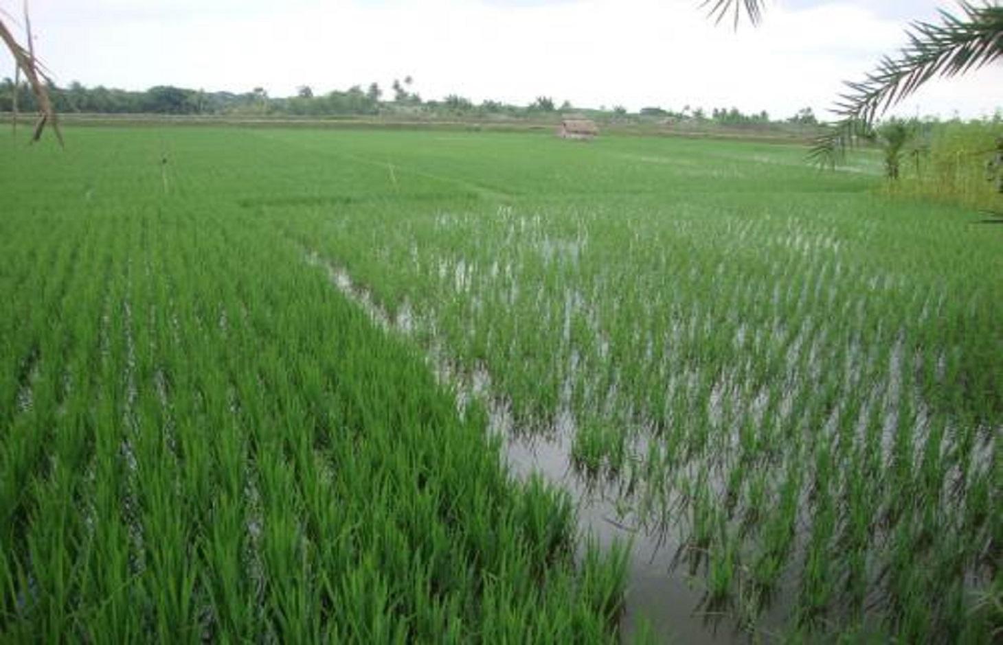
Gher (shrimp cultivation) boundary usage for multiple cropping.
2.2 การอธิบายแบบละเอียดของเทคโนโลยี
คำอธิบาย:
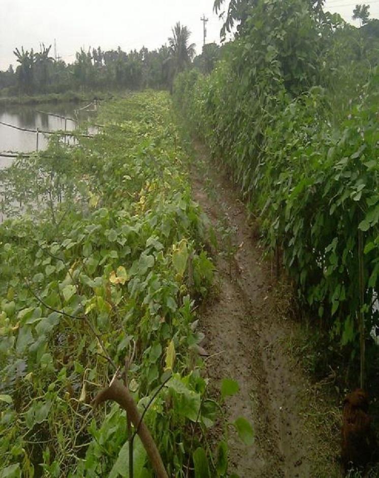
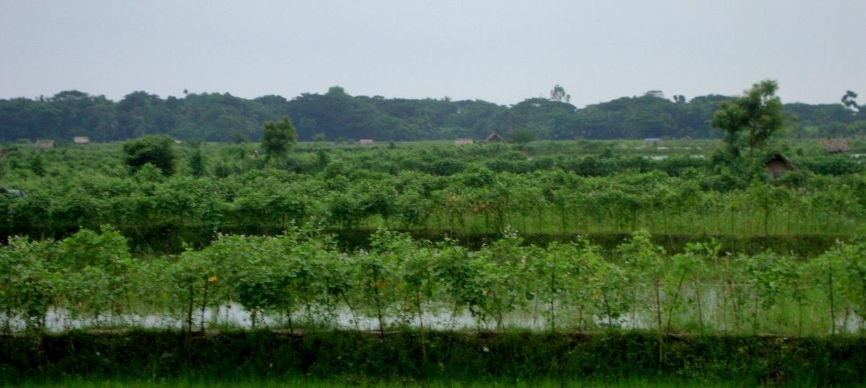
Gher is a local word used for shrimp cultivation plot. The boundaries of these ghers are nowadays raised and maintained to grow vegetables, fruits and also some tree species. In this case the boundary of the plot is raised at least 3 feet with grest width 1 feet plus depending on the height of the boundary (Bund/dyke). Within the gher the land is used for both sweet water prawn (Golda) or saline water prawn (Bagda) with other different types of fishes (locally called Sada Mach) if suitable depending on the salinity of water. Some of the gher lands are used for transplanted Aman with shrimp/fishes.
Farmers dug a ditch along the boundary or in any corner of the field or at the center of the plot to preserve water and fishes during the dry season. In some of the cases the farmers used shallow tube well water to sustain the fishes. In non-to slightly saline areas they used it even for boro (winter rice).
Purpose of the Technology: The purpose of this technology is a boundary which is used for various types of crops, including year round vegetables and land for rice and fishes including shrimps.
Establishment / maintenance activities and inputs: The boundary is constructed above flood level (2-3 feet), the width is approx. 2-3 feet, the ditches are 2-3 feet deep along the boundary or at the corner or at the center.
To grow vegetables farmers used nylon nets for creeping supported by the bamboo or Dhaincha or strings.
Top soils kept on top of the bunds to avoid relatively less fertile soil on the bunds.
Main inputs are seeds of vegetables, nets, bamboo, strings, fingerlings of fish etc.
Natural / human environment: The salinity of the soils from the bunds is washed away by rainwater, which facilitates vegetable production: Rain water desolves salt and moves to the bottom of the bund, and soil becomes non-saline or slightly saline where vegetable could be grown.
2.3 รูปภาพของเทคโนโลยี
อัลบั้มสื่อบันทึก
2.5 ประเทศภูมิภาค หรือสถานที่ตั้งที่เทคโนโลยีได้นำไปใช้และได้รับการครอบคลุมโดยการประเมินนี้
ประเทศ:
บังกลาเทศ
ภูมิภาค/รัฐ/จังหวัด:
Bangladesh Southern region
ข้อมูลจำเพาะเพิ่มเติมของสถานที่ตั้ง :
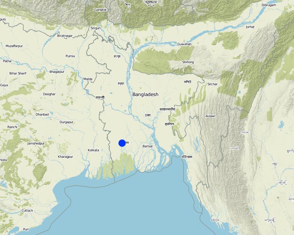
Khulna
Map
×2.6 วันที่การดำเนินการ
ถ้าไม่รู้ปีที่แน่นอน ให้ระบุวันที่โดยประมาณ:
- น้อยกว่า 10 ปี (ไม่นานนี้)
2.7 คำแนะนำของเทคโนโลยี
ให้ระบุว่าเทคโนโลยีถูกแนะนำเข้ามาอย่างไร:
- ด้วยการริเริ่มของผู้ใช้ที่ดินเอง
3. การจัดประเภทของเทคโนโลยี SLM
3.1 วัตถุประสงค์หลักของเทคโนโลยี
- ปรับปรุงการผลิตให้ดีขึ้น
3.2 ประเภทของการใช้ที่ดินในปัจจุบันที่ได้นำเทคโนโลยีไปใช้

พื้นที่ปลูกพืช
- การปลูกพืชล้มลุกอายุปีเดียว

การใช้ที่ดินแบบผสมผสาน (รวมถึงวนเกษตร)
- Cropland and aquaculture
แสดงความคิดเห็น:
Major land use problems (compiler’s opinion): Soil and water salinity during dry season; tidal surge; cyclones
Major land use problems (land users’ perception): Water salinity; tidal surge; sidre (name of a cyclone)
Future (final) land use (after implementation of SLM Technology): Mixed: Mo: Other
Type of cropping system and major crops comments: Gher use is very much variable. The main issue of using land is to adapt soil and water salinity. Some ghers are used for only shrimp, some are mixed with other fishes, some are mixed with transplanted Aman. But the boundary/bunds are used for year round vegetables, Banana, fruits (Kul, Guava, Mango) etc.
ถ้าการใช้ที่ดินมีการเปลี่ยนแปลงเนื่องมาจากการนำเทคโนโลยีไปปฏิบัติใช้ ให้ระบุการใช้ที่ดินก่อนนำเทคโนโลยีไปปฏิบัติใช้:
Mixed: Mo: Other
3.3 ข้อมูลเพิ่มเติมเกี่ยวกับการใช้ที่ดิน
การใช้น้ำของที่ดินที่มีการใช้เทคโนโลยีอยู่:
- จากน้ำฝน
แสดงความคิดเห็น:
Also mixed rainfed - irrigated
จำนวนของฤดูเพาะปลูกต่อปี:
- 1
ระบุ:
Longest growing period in days: 160; Longest growing period from month to month: July to Sept
3.4 กลุ่ม SLM ที่ตรงกับเทคโนโลยีนี้
- การเลี้ยงผึ้ง การเพาะเลี้ยงสัตว์น้ำ สัตว์ปีก ฟาร์มกระต่าย ฟาร์มหนอนไหม
3.5 กระจายตัวของเทคโนโลยี
ระบุการกระจายตัวของเทคโนโลยี:
- กระจายไปอย่างสม่ำเสมอในพื้นที่
ถ้าหากว่าเทคโนโลยีได้มีการกระจายออกไปอย่างสม่ำเสมอในพื้นที่ ให้ระบุปริมาณพื้นที่ที่ได้รับการครอบคลุมถึง:
- 1-10 ตร.กม.
แสดงความคิดเห็น:
Gher (Shrimp cultivation) boundary used for multiple crops; vegetables, fruits, tree etc in southern coastal region of Bangladesh.
3.6 มาตรการ SLM ที่ประกอบกันเป็นเทคโนโลยี

มาตรการจัดการพืช
- A1: พืช/สิ่งปกคลุมดิน

มาตรการอนุรักษ์ด้วยโครงสร้าง
- S2: ทำนบ เขื่อนดิน

มาตรการอนุรักษ์ด้วยการจัดการ
- M1: การเปลี่ยนรูปแบบของการใช้ประโยชน์ที่ดิน
แสดงความคิดเห็น:
Type of agronomic measures: better crop cover, mixed cropping / intercropping
3.7 รูปแบบหลักของการเสื่อมโทรมของที่ดินที่ได้รับการแก้ไขโดยเทคโนโลยี

การเสื่อมโทรมของดินทางด้านเคมี
- Cs (Salinization/alkalinization): การสะสมเกลือหรือการทำให้เป็นด่าง
แสดงความคิดเห็น:
Main causes of degradation: other natural causes (avalanches, volcanic eruptions, mud flows, highly susceptible natural resources, extreme topography, etc.) specify (Salinization: salination of top soil is due to saline ground water coming in shallow depth), Salinization (The area under this issue is in coastal zone. Conflict of land use is prominent. The lands became saline as other stakeholders keep saline water for other uses (salt production, shrimp))
3.8 การป้องกัน การลดลง หรือการฟื้นฟูความเสื่อมโทรมของที่ดิน
ระบุเป้าหมายของเทคโนโลยีกับความเสื่อมโทรมของที่ดิน:
- ฟื้นฟูบำบัดที่ดินที่เสื่อมโทรมลงอย่างมาก
4. ข้อมูลจำเพาะด้านเทคนิค กิจกรรมการนำไปปฏิบัติใช้ ปัจจัยนำเข้า และค่าใช้จ่าย
4.1 แบบแปลนทางเทคนิคของเทคโนโลยี
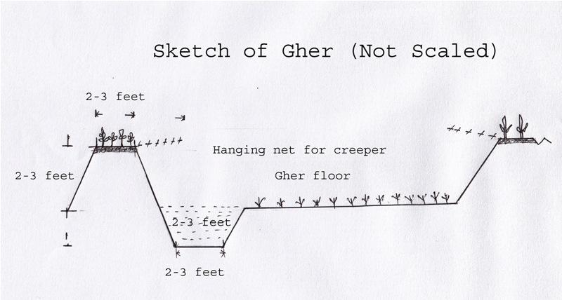
ผู้เขียน:
Shoaib Jalal
4.2 ข้อมูลจำเพาะด้านเทคนิคและการอธิบายแบบแปลนทางเทคนิค
The gher boundary is raised approximately 2-3 feet with a crest of 2-3 feet. A ditch also dug to store water and fish during dry season.
Location: Dumuria. Khulna
Date: 03-09-13
Technical knowledge required for field staff / advisors: moderate (It is only land manipulation.)
Technical knowledge required for land users: moderate (Previously farmer did not put the top soil on the top of the bunds. That impedes crop production on bunds.)
Main technical functions: increase in nutrient availability (supply, recycling,…), water harvesting / increase water supply, improvement of water quality, buffering / filtering water, promotion of vegetation species and varieties (quality, eg palatable fodder), spatial arrangement and diversification of land use, Decrease of soil salinity, Increase of options for growing more crops
Agronomic measure: Top soil kept on top
Structural measure: Bunds
Height of bunds/banks/others (m): 1
Width of bunds/banks/others (m): 0.5-1
Length of bunds/banks/others (m): 10-50
Construction material (earth): Bunds are raised by piling earth
Change of land use practices / intensity level: Bunds are used for year round cropping
4.3 ข้อมูลทั่วไปเกี่ยวกับการคำนวณปัจจัยนำเข้าและค่าใช้จ่าย
อื่นๆ หรือสกุลเงินประจำชาติ (ระบุ):
Taka
ระบุอัตราแลกเปลี่ยนจากดอลลาร์สหรัฐเป็นสกุลเงินท้องถิ่น (ถ้าเกี่ยวข้อง) คือ 1 เหรียญสหรัฐ =:
79.0
4.4 กิจกรรมเพื่อการจัดตั้ง
| กิจกรรม | ประเภทของมาตรการ | ช่วงเวลาดำเนินการ | |
|---|---|---|---|
| 1. | Farmers cut the earth from adjacent lands | ด้วยโครงสร้าง | Nov-Dec |
4.5 ค่าใช้จ่ายของปัจจัยนำเข้าที่จำเป็นสำหรับการจัดตั้ง
| ปัจจัยนำเข้า | หน่วย | ปริมาณ | ค่าใช้จ่ายต่อหน่วย | ค่าใช้จ่ายทั้งหมดต่อปัจจัยนำเข้า | %ของค่าใช้จ่ายที่ก่อให้เกิดขึ้นโดยผู้ใช้ที่ดิน | |
|---|---|---|---|---|---|---|
| แรงงาน | Farmers cut the earth from adjacent lands | ha | 10.0 | 65.0 | 650.0 | 100.0 |
| แรงงาน | Labour | ha | 2.0 | 300.0 | 600.0 | 100.0 |
| แรงงาน | Watch and ward | ha | 1.0 | 300.0 | 300.0 | 100.0 |
| อุปกรณ์ | Seeds, nets etc | ha | 1.0 | 50.0 | 50.0 | 100.0 |
| ปุ๋ยและสารฆ่า/ยับยั้งการเจริญเติบโตของสิ่งมีชีวิต (ไบโอไซด์) | Fertilizer | ha | 1.0 | 5.0 | 5.0 | 100.0 |
| ค่าใช้จ่ายทั้งหมดของการจัดตั้งเทคโนโลยี | 1605.0 | |||||
แสดงความคิดเห็น:
Duration of establishment phase: 1 month(s)
4.6 การบำรุงรักษาสภาพหรือกิจกรรมที่เกิดขึ้นเป็นประจำ
| กิจกรรม | ประเภทของมาตรการ | ช่วงระยะเวลา/ความถี่ | |
|---|---|---|---|
| 1. | Transplanting seedlings/seeds | จัดการพืช | July/Nov |
| 2. | Cultural practices | จัดการพืช | Aug-Oct/Dec-March |
4.7 ค่าใช้จ่ายของปัจจัยนำเข้าและกิจกรรมที่เกิดขึ้นเป็นประจำที่ต้องการการบำรุงรักษา (ต่อปี)
| ปัจจัยนำเข้า | หน่วย | ปริมาณ | ค่าใช้จ่ายต่อหน่วย | ค่าใช้จ่ายทั้งหมดต่อปัจจัยนำเข้า | %ของค่าใช้จ่ายที่ก่อให้เกิดขึ้นโดยผู้ใช้ที่ดิน | |
|---|---|---|---|---|---|---|
| แรงงาน | Transplanting seedlings/seeds | persons/day/ha | 2.0 | 10.0 | 20.0 | 100.0 |
| ค่าใช้จ่ายทั้งหมดของการบำรุงรักษาสภาพเทคโนโลยี | 20.0 | |||||
แสดงความคิดเห็น:
Piling earth to construct gher bunds
4.8 ปัจจัยสำคัญที่สุดที่มีผลกระทบต่อค่าใช้จ่าย
ปัจจัยสำคัญที่สุดที่มีผลกระทบต่อค่าใช้จ่ายต่างๆ:
Availability of labour
5. สิ่งแวดล้อมทางธรรมชาติและของมนุษย์
5.1 ภูมิอากาศ
ฝนประจำปี
- < 250 ม.ม.
- 251-500 ม.ม.
- 501-750 ม.ม.
- 751-1,000 ม.ม.
- 1,001-1,500 ม.ม.
- 1,501-2,000 ม.ม.
- 2,001-3,000 ม.ม.
- 3,001-4,000 ม.ม.
- > 4,000 ม.ม.
ข้อมูลจำเพาะ/ความคิดเห็นเรื่องปริมาณน้ำฝน:
Most of the rainfall experienced in rainy season
เขตภูมิอากาศเกษตร
- ชื้น
Thermal climate class: tropics
5.2 สภาพภูมิประเทศ
ค่าเฉลี่ยความลาดชัน:
- ราบเรียบ (0-2%)
- ลาดที่ไม่ชัน (3-5%)
- ปานกลาง (6-10%)
- เป็นลูกคลื่น (11-15%)
- เป็นเนิน (16-30%)
- ชัน (31-60%)
- ชันมาก (>60%)
ธรณีสัณฐาน:
- ที่ราบสูง/ที่ราบ
- สันเขา
- ไหล่เขา
- ไหล่เนินเขา
- ตีนเนิน
- หุบเขา
ระดับความสูง:
- 0-100 เมตร
- 101-500 เมตร
- 501-1,000 เมตร
- 1,001-1,500 เมตร
- 1,501-2,000 เมตร
- 2,001-2,500 เมตร
- 2,501-3,000 เมตร
- 3,001-4,000 เมตร
- > 4,000 เมตร
ความคิดเห็นและข้อมูลจำเพาะเพิ่มเติมเรื่องสภาพภูมิประเทศ:
Landforms: Coastal plain, narrow ridge with broad flat basin
5.3 ดิน
ค่าเฉลี่ยความลึกของดิน:
- ตื้นมาก (0-20 ซ.ม.)
- ตื้น (21-50 ซ.ม.)
- ลึกปานกลาง (51-80 ซ.ม.)
- ลึก (81-120 ซ.ม.)
- ลึกมาก (>120 ซ.ม.)
เนื้อดิน (ดินชั้นบน):
- ปานกลาง (ดินร่วน ทรายแป้ง)
- ละเอียด/หนัก (ดินเหนียว)
อินทรียวัตถุในดิน:
- ต่ำ (<1%)
(ถ้ามี) ให้แนบคำอธิบายเรื่องดินแบบเต็มหรือระบุข้อมูลที่มีอยู่ เช่น ชนิดของดิน ค่า pH ของดินหรือความเป็นกรดของดิน ความสามารถในการแลกเปลี่ยนประจุบวก ไนโตรเจน ความเค็ม เป็นต้น:
Soil fertility is low
Soil drainage / infiltration is poor
Soil water storage capacity is very low - low
5.4 ความเป็นประโยชน์และคุณภาพของน้ำ
ระดับน้ำใต้ดิน:
<5 เมตร
น้ำไหลบ่าที่ผิวดิน:
ไม่ดีหรือไม่มีเลย
คุณภาพน้ำ (ที่ยังไม่ได้บำบัด):
เป็นน้ำใช้เพื่อการเกษตรเท่านั้น (การชลประทาน)
5.5 ความหลากหลายทางชีวภาพ
ความหลากหลายทางชนิดพันธุ์:
- ต่ำ
5.6 ลักษณะของผู้ใช้ที่ดินที่นำเทคโนโลยีไปปฏิบัติใช้
แนวทางการตลาดของระบบการผลิต:
- ผสม (การเลี้ยงชีพ/ทำการค้า)
- ทำการค้า/การตลาด
รายได้ที่มาจากนอกฟาร์ม:
- 10-50% ของรายได้ทั้งหมด
ระดับของความมั่งคั่งโดยเปรียบเทียบ:
- จน
เป็นรายบุคคล/ครัวเรือน:
- เป็นรายบุคคล/ครัวเรือน
ระดับของการใช้เครื่องจักรกล:
- การใช้เครื่องจักรหรือเครื่องยนต์
เพศ:
- ชาย
ระบุลักษณะอื่นๆที่เกี่ยวข้องของผู้ใช้ที่ดิน:
Land users applying the Technology are mainly common / average land users
Difference in the involvement of women and men: Women casually worked during harvesting vegetables
Population density: > 500 persons/km2
Annual population growth: 2% - 3%
70% of the land users are poor.
Level of mechanization: Power triller on hire.
5.7 พื้นที่เฉลี่ยของที่ดินที่เป็นเจ้าของหรือเช่าโดยผู้ใช้ที่ดินที่นำเทคโนโลยีไปปฏิบัติใช้
- < 0.5 เฮกตาร์
- 0.5-1 เฮกตาร์
- 1-2 เฮกตาร์
- 2-5 เฮกตาร์
- 5-15 เฮกตาร์
- 15-50 เฮกตาร์
- 50-100 เฮกตาร์
- 100-500 เฮกตาร์
- 500-1,000 เฮกตาร์
- 1,000-10,000 เฮกตาร์
- >10,000 เฮกตาร์
พิจารณาว่าเป็นขนาดเล็ก กลาง หรือขนาดใหญ่ (ซึ่งอ้างอิงถึงบริบทระดับท้องถิ่น):
- ขนาดเล็ก
แสดงความคิดเห็น:
15-50 ha: Mainly owner of lands of this area
5.8 กรรมสิทธิ์ในที่ดิน สิทธิในการใช้ที่ดินและสิทธิในการใช้น้ำ
กรรมสิทธิ์ในที่ดิน:
- รายบุคคล ได้รับสิทธิครอบครอง
สิทธิในการใช้ที่ดิน:
- เช่า
- รายบุคคล
สิทธิในการใช้น้ำ:
- เช่า
- รายบุคคล
5.9 การเข้าถึงบริการและโครงสร้างพื้นฐาน
สุขภาพ:
- จน
- ปานกลาง
- ดี
การศึกษา:
- จน
- ปานกลาง
- ดี
ความช่วยเหลือทางด้านเทคนิค:
- จน
- ปานกลาง
- ดี
การจ้างงาน (เช่น ภายนอกฟาร์ม):
- จน
- ปานกลาง
- ดี
ตลาด:
- จน
- ปานกลาง
- ดี
พลังงาน:
- จน
- ปานกลาง
- ดี
ถนนและการขนส่ง:
- จน
- ปานกลาง
- ดี
น้ำดื่มและการสุขาภิบาล:
- จน
- ปานกลาง
- ดี
บริการด้านการเงิน:
- จน
- ปานกลาง
- ดี
6. ผลกระทบและสรุปคำบอกกล่าว
6.1 ผลกระทบในพื้นที่ดำเนินการ (On-site) จากการใช้เทคโนโลยี
ผลกระทบทางด้านเศรษฐกิจและสังคม
การผลิต
การผลิตพืชผล
แสดงความคิดเห็น/ระบุ:
Desalinized soil of the bund
ผลกระทบด้านสังคมวัฒนธรรมอื่น ๆ
ความมั่นคงด้านอาหาร / พึ่งตนเองได้
สถานการณ์ด้านสุขภาพ
โอกาสทางวัฒนธรรม
แสดงความคิดเห็น/ระบุ:
Cash from vegetables
การบรรเทาความขัดแย้ง
แสดงความคิดเห็น/ระบุ:
Conflicts to use water resource
สถานการณ์ของกลุ่มด้อยโอกาส ทางด้านสังคมและเศรษฐกิจ
livelihood and human well-being
แสดงความคิดเห็น/ระบุ:
Growing and marketing of year round vegetables help the farmer to get cash money throughout the year. That improves their livelihood and access to health care, education etc.
ผลกระทบด้านนิเวศวิทยา
วัฐจักรน้ำหรือน้ำบ่า
การระบายน้ำส่วนเกิน
แสดงความคิดเห็น/ระบุ:
Ghers are ponded and no water can be drained
ดิน
ความเค็ม
แสดงความคิดเห็น/ระบุ:
+ Soil salinity reduced as washed by rainwater -> found in soils of Gher bunds
- Due to ground water abstraction -> found in coastal regions, increasing trend
ความหลากหลายทางชีวภาพของพืชและสัตว์
ความหลากหลายทางชีวภาพของพืช
ลดความเสี่ยงของภัยพิบัติ
การปล่อยคาร์บอนและก๊าซเรือนกระจก
6.3 การเผชิญและความตอบสนองของเทคโนโลยีต่อการเปลี่ยนแปลงสภาพภูมิอากาศที่ค่อยเป็นค่อยไป และสภาพรุนแรงของภูมิอากาศ / ภัยพิบัติ (ที่รับรู้ได้โดยผู้ใช้ที่ดิน)
การเปลี่ยนแปลงสภาพภูมิอากาศที่ค่อยเป็นค่อยไป
การเปลี่ยนแปลงสภาพภูมิอากาศที่ค่อยเป็นค่อยไป
| ฤดู | ประเภทของการเปลี่ยนแปลงสภาพภูมิอากาศที่ค่อยเป็นค่อยไป และสภาพรุนแรงของภูมิอากาศ | เทคโนโลยีมีวิธีการรับมืออย่างไร | |
|---|---|---|---|
| อุณหภูมิประจำปี | เพิ่มขึ้น | ไม่ค่อยดี |
สภาพรุนแรงของภูมิอากาศ (ภัยพิบัติ)
ภัยพิบัติทางอุตุนิยมวิทยา
| เทคโนโลยีมีวิธีการรับมืออย่างไร | |
|---|---|
| พายุฝนประจำท้องถิ่น | ไม่ค่อยดี |
| พายุลมประจำท้องถิ่น | ไม่ค่อยดี |
แสดงความคิดเห็น:
Salinity is washed out from the bund by rainwater. Consequently year round vegetable can be grown on bunds of the gher besides fish in the main land or transplanted rice (depending on the salinity of soil and water and choice of farmers).
6.4 การวิเคราะห์ค่าใช้จ่ายและผลประโยชน์ที่ได้รับ
ผลประโยชน์ที่ได้รับเปรียบเทียบกับค่าใช้จ่ายในการจัดตั้งเป็นอย่างไร (จากมุมมองของผู้ใช้ที่ดิน)
ผลตอบแทนระยะสั้น:
ด้านบวกอย่างมาก
ผลตอบแทนระยะยาว:
ด้านบวกเล็กน้อย
ผลประโยชน์ที่ได้รับเปรียบเทียบกับค่าใช้จ่ายในการบำรุงรักษาหรือต้นทุนที่เกิดขึ้นซ้ำอีก เป็นอย่างไร (จากมุมมองของผู้ใช้ที่ดิน)
ผลตอบแทนระยะสั้น:
ด้านบวกอย่างมาก
ผลตอบแทนระยะยาว:
ด้านบวกเล็กน้อย
แสดงความคิดเห็น:
Long term benefit is yet to be observed
6.5 การปรับตัวของเทคโนโลยี
แสดงความคิดเห็น:
There is a moderate trend towards spontaneous adoption of the Technology
Comments on adoption trend: Leased land users are not capable to adopt the technology.
6.7 จุดแข็ง / ข้อได้เปรียบ / โอกาสของเทคโนโลยี
| จุดแข็ง / ข้อได้เปรียบ / โอกาสในทัศนคติของผู้ใช้ที่ดิน |
|---|
|
Growing more crops will benefit the farmer with more return. As of now marketing of the goods are facilitated by local small entrepreneurs. Most of them have poor linkage with broader markets. How can they be sustained / enhanced? These entrepreneurs could be appropriately linked with bigger one at regional levels (Upazila/ Districts). At the same time road net works are to be alleviated to facilitate access of transport to carry farmers good with all securities. |
| จุดแข็ง / ข้อได้เปรียบ / โอกาสในทัศนคติของผู้รวบรวมหรือวิทยากรหลัก |
|---|
|
Land could be used as farmers are managing themselves How can they be sustained / enhanced? To sustain production and produce such as vegetables and fishes deserve uninterrupted marketing linkage essential. |
|
Changes in land management by the farmer to grow multiple crops indeed scale up their economy than before. How can they be sustained / enhanced? To sustain the farming system good variety and quality seeds supply will enhance the scenario. |
6.8 จุดอ่อน / ข้อเสียเปรียบ / ความเสี่ยงของเทคโนโลยีและวิธีการแก้ไข
| จุดอ่อน / ข้อเสียเปรียบ / ความเสี่ยงในทัศนคติของผู้ใช้ที่ดิน | มีวิธีการแก้ไขได้อย่างไร |
|---|---|
| Water management of the areas became critical, specially sweet water | Good water management system is to be introduced through local and regional planning. |
| Conflicts of land uses are prominent. | Social awareness and concept of land zoning seems to be essentials at all levels. |
| จุดอ่อน / ข้อเสียเปรียบ / ความเสี่ยงในทัศนคติของผู้รวบรวมหรือวิทยากรหลัก | มีวิธีการแก้ไขได้อย่างไร |
|---|---|
| Due to construction or rearrangement of field bunds (Dykes) almost all drainages ways blocked. Consequently the whole area became water logged. This situation will definitely aggravate soil quality, environment and ultimate ecosystem | Community approach to manage the landscape will be effective. In this regard local administration and community leaders can play a vital role. |
| Soils of Gher boundaries (Dykes) are subject to erosion when exposed to rain water. | Good cover crops and management are necessary to protect soils from erosion. At same time farmers may be trained on this issue. |
ลิงก์และโมดูล
ขยายทั้งหมด ย่อทั้งหมดลิงก์
ไม่มีลิงก์
โมดูล
ไม่มีโมดูล