
Kanda [อัฟกานิสถาน]
- ผู้สร้างสรรค์:
- การอัพเดท:
- ผู้รวบรวม: Aqila Haidery
- ผู้เรียบเรียง: –
- ผู้ตรวจสอบ: David Streiff
Kanda
technologies_1659 - อัฟกานิสถาน
ดูส่วนย่อย
ขยายทั้งหมด ย่อทั้งหมด1. ข้อมูลทั่วไป
1.2 รายละเอียดที่ติดต่อได้ของผู้รวบรวมและองค์กรที่เกี่ยวข้องในการประเมินและการจัดเตรียมทำเอกสารของเทคโนโลยี
ผู้เชี่ยวชาญ SLM:
ผู้เชี่ยวชาญ SLM:
ผู้เชี่ยวชาญ SLM:
ผู้เชี่ยวชาญ SLM:
Sediqi Ali Ahmad
Helvetas Swiss Intercooperation
อัฟกานิสถาน
ผู้เชี่ยวชาญ SLM:
Sthapit Keshar
Helvetas Swiss Intercooperation
อัฟกานิสถาน
ผู้เชี่ยวชาญ SLM:
Arbab Ziauddin
Sourakhak Watershed Committee, Kahmard
อัฟกานิสถาน
ชื่อขององค์กรซึ่งอำนวยความสะดวกในการทำเอกสารหรือการประเมินเทคโนโลยี (ถ้าเกี่ยวข้อง)
HELVETAS (Swiss Intercooperation)1.3 เงื่อนไขการใช้ข้อมูลที่ได้บันทึกผ่านทาง WOCAT
วันที่เก็บรวบรวมข้อมูล(ภาคสนาม) :
30/12/2012
ผู้รวบรวมและวิทยากรหลักยอมรับเงื่อนไขเกี่ยวกับการใช้ข้อมูลที่ถูกบันทึกผ่านทาง WOCAT:
ใช่
2. การอธิบายลักษณะของเทคโนโลยี SLM
2.1 การอธิบายแบบสั้น ๆ ของเทคโนโลยี
คำจำกัดความของเทคโนโลยี:
A traditional underground water tank carved out of rocks to collect rainfall and snow water and reduce evaporation losses.
2.2 การอธิบายแบบละเอียดของเทคโนโลยี
คำอธิบาย:
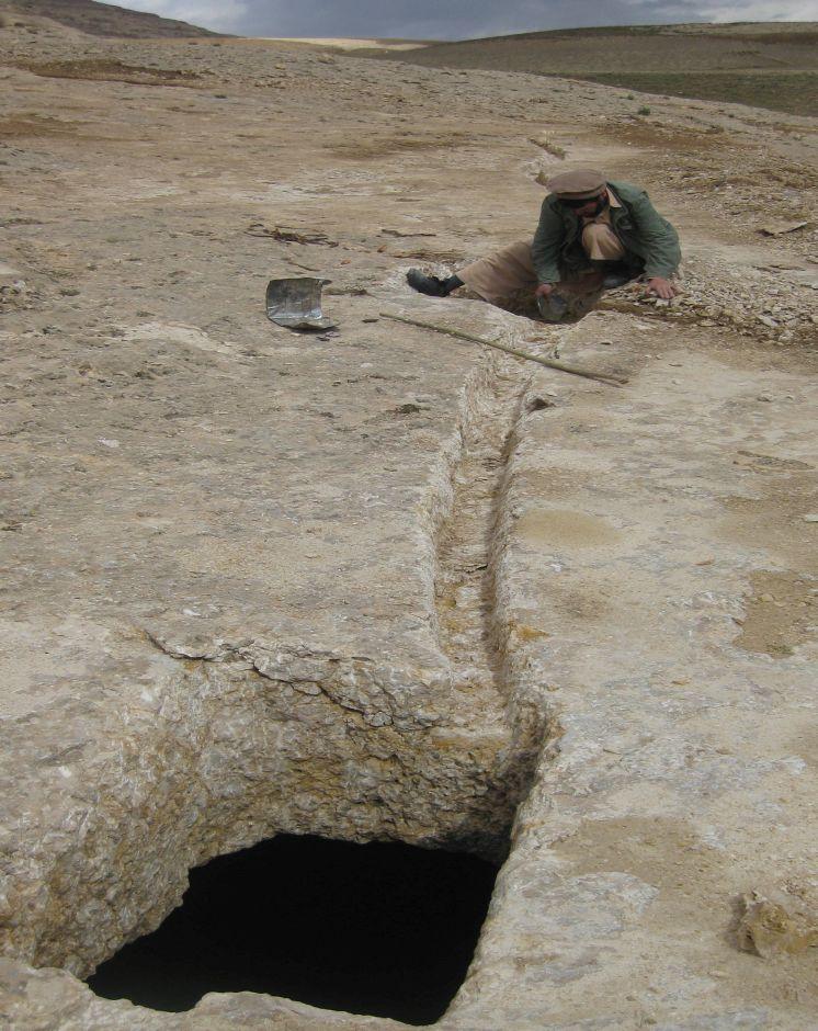
Kanda is an indigenous technology for collecting rain and snow melt. The technology comprises an underground tank carved out of rock (limestone), channels to convey the runoff into the underground tank or kanda and a rocky catchment from where runoff is collected. Kanda technology is applied in Afghanistan in many places, particularly in areas which experience scarcity of water for human beings, livestock and irrigation.
Purpose of the Technology: Due to high evaporation rates and low precipitation, harvesting runoff in open tanks is not an efficient way of water harvesting. HELVETAS Swiss Intercooperation is implementing community based watershed management projects in Kahmard district of Bamyan province (Afghanistan) since 2008 with financial support from the International Swiss Re Award for sustainable watershed management (2009) and the Swiss Agency for Development and Cooperation (SDC). One of the activities for sustainable watershed management is plantation of fruit and non-fruit trees in the selected watersheds (upland areas) which were used for grazing and extraction of vegetation for domestic use. Due to water scarcity in the upland areas, irrigation of the planted saplings becomes very difficult and water has to be transported on donkey from far locations. To overcome this constraint, Kanda was identified as the most potent technology for harvesting runoff and snow melt.
Establishment / maintenance activities and inputs: For constructing Kandas, Kanda makers from Dara-e Suf district in Samangan province had to employed as there are no experts in Kahmard. Based on feasibility studies, eight kandas have been constructed including 4 kandas in Sourakhak wa-tershed and 4 in Baqa Kushta watershed. The size of each kanda is 6 m length, 6 m in width and 3 m in height. To convey the runoff into the tank, 10-20 m long graded channels were carved out of the rocks. The establishment cost of one Kan-da was approximately US$ 7163. Kanda making requires special skills, especially when it is carved out of rocks. A kanda maker has sound understanding of the area’s geology, and this wisdom is gained through learning by doing and ances-tors.. In Kahmard, 2-3 experts worked for 4-5 months for one Kanda.
Natural / human environment: In 2012, due to sufficient rains, 2 Kandas which did not have leakage problems in Sourakhak watershed got full with runoff water, which was then used for irrigating 6500 saplings seven times during the year. Kahmard district has a semi-arid cli-mate. Some years are dry with rainfall of about 190 mm. Considering this context, it becomes very necessary to tap rainwater, especially in the rainfed uplands, and use it for irrigating saplings or for livestock.
2.3 รูปภาพของเทคโนโลยี
อัลบั้มสื่อบันทึก
2.5 ประเทศภูมิภาค หรือสถานที่ตั้งที่เทคโนโลยีได้นำไปใช้และได้รับการครอบคลุมโดยการประเมินนี้
ประเทศ:
อัฟกานิสถาน
ภูมิภาค/รัฐ/จังหวัด:
Bamyan
ข้อมูลจำเพาะเพิ่มเติมของสถานที่ตั้ง :
Kahmard
2.6 วันที่การดำเนินการ
ถ้าไม่รู้ปีที่แน่นอน ให้ระบุวันที่โดยประมาณ:
- มากกว่า 50 ปี (แบบดั้งเดิม)
2.7 คำแนะนำของเทคโนโลยี
ให้ระบุว่าเทคโนโลยีถูกแนะนำเข้ามาอย่างไร:
- ทางโครงการหรือจากภายนอก
ความคิดเห็น (ประเภทของโครงการ เป็นต้น) :
Kanda technology is an age old water harvesting traditional technology.
3. การจัดประเภทของเทคโนโลยี SLM
3.1 วัตถุประสงค์หลักของเทคโนโลยี
- access to water
3.2 ประเภทของการใช้ที่ดินในปัจจุบันที่ได้นำเทคโนโลยีไปใช้

ทุ่งหญ้าเลี้ยงสัตว์
ทุ่งหญ้าเลี้ยงสัตว์ที่ใช้พื้นที่กว้าง:
- กึ่งเร่ร่อน / อาจมีการทำทุ่งหญ้าเลี้ยงสัตว์ร่วมด้วย (Semi-nomadism/ pastoralism)
ทุ่งหญ้าเลี้ยงสัตว์ที่มีการจัดการแบบเข้มข้นหรือการผลิตอาหารสัตว์:
- ทุ่งหญ้าเลี้ยงสัตว์ที่ได้มีการปรับปรุง (Improved pastures)
ชนิดพันธุ์สัตว์และผลิตภัณฑ์หลัก:
Sheeps, goats
แสดงความคิดเห็น:
Major land use problems (compiler’s opinion): Scarcity of water in the upland makes plantation activities and livestock productivity difficult. Carrying water from far places for irrigating plants is an expensive activity.
Major land use problems (land users’ perception): Degraded upland watershed resulting severe flash flood.
Forest products and services: timber, fuelwood, fruits and nuts, grazing / browsing, nature conservation / protection, protection against natural hazards
Other forest products and services: flash flood
Future (final) land use (after implementation of SLM Technology): Grazing land: Gi: Intensive grazing/ fodder production
ถ้าการใช้ที่ดินมีการเปลี่ยนแปลงเนื่องมาจากการนำเทคโนโลยีไปปฏิบัติใช้ ให้ระบุการใช้ที่ดินก่อนนำเทคโนโลยีไปปฏิบัติใช้:
Grazing land: Ge: Extensive grazing land
3.3 ข้อมูลเพิ่มเติมเกี่ยวกับการใช้ที่ดิน
การใช้น้ำของที่ดินที่มีการใช้เทคโนโลยีอยู่:
- จากน้ำฝน
ระบุ:
Longest growing period in days: 90; Longest growing period from month to month: March-July
3.4 กลุ่ม SLM ที่ตรงกับเทคโนโลยีนี้
- การเก็บเกี่ยวน้ำ
3.5 กระจายตัวของเทคโนโลยี
ระบุการกระจายตัวของเทคโนโลยี:
- ใช้ ณ จุดที่เฉพาะเจาะจงหรือเน้นไปยังบริเวณพื้นที่ขนาดเล็ก
แสดงความคิดเห็น:
Total area covered by the SLM Technology is 0.005 km2.
3.6 มาตรการ SLM ที่ประกอบกันเป็นเทคโนโลยี

มาตรการอนุรักษ์ด้วยโครงสร้าง
- S11: อื่น ๆ
แสดงความคิดเห็น:
Specification of other structural measures: Under ground cistern
3.7 รูปแบบหลักของการเสื่อมโทรมของที่ดินที่ได้รับการแก้ไขโดยเทคโนโลยี

การกัดกร่อนของดินโดยน้ำ
- Wt (Loss of topsoil): การสูญเสียดินชั้นบนหรือการกัดกร่อนที่ผิวดิน

การเสื่อมโทรมของดินทางด้านชีวภาพ
- Bc (Reduction of vegetation cover): การลดลงของจำนวนพืชที่ปกคลุมดิน
แสดงความคิดเห็น:
Secondary types of degradation addressed: Wt: loss of topsoil / surface erosion
Main causes of degradation: over-exploitation of vegetation for domestic use (Bush collection for fire wood), overgrazing (By sheep and goets), droughts (Natural climate phenomenon), land tenure (Common land without good management), poverty / wealth, governance / institutional (Lack of organizationals for organization for supporting management of common resources.)
Secondary causes of degradation: crop management (annual, perennial, tree/shrub) (Rainfed agriculture), Heavy / extreme rainfall (intensity/amounts) (Change in climate patterns), population pressure (Fast increasing population which depands on natural resources for livelihoods), war and conflicts (Leading to uncontrolled cutting down of trees and shrubes)
3.8 การป้องกัน การลดลง หรือการฟื้นฟูความเสื่อมโทรมของที่ดิน
ระบุเป้าหมายของเทคโนโลยีกับความเสื่อมโทรมของที่ดิน:
- ฟื้นฟูบำบัดที่ดินที่เสื่อมโทรมลงอย่างมาก
4. ข้อมูลจำเพาะด้านเทคนิค กิจกรรมการนำไปปฏิบัติใช้ ปัจจัยนำเข้า และค่าใช้จ่าย
4.1 แบบแปลนทางเทคนิคของเทคโนโลยี
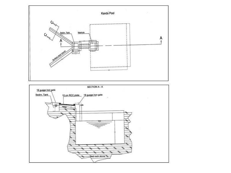
ผู้เขียน:
Helvetas Swiss Intercooperatio, Kabul Afghanistan
4.2 ข้อมูลจำเพาะด้านเทคนิคและการอธิบายแบบแปลนทางเทคนิค
Technical drawing of a Kanda constructed at Baqa Kushta watershed in Kahmard district (Bamyan province).
Size of one Kanda tank:
Length:6m
Width :6m
Height:3m
108 cu.m water can be stored in one Kanda.
Location: Baqa Koshta watershed. Kahmard
Date: 24/03/2013
Technical knowledge required for field staff / advisors: high
Technical knowledge required for land users: high
Main technical functions: control of concentrated runoff: retain / trap, water harvesting / increase water supply, Reduction in evaporation and seepage losses
Secondary technical functions: improvement of ground cover
Structural measure: cistern(from rock)
Depth of ditches/pits/dams (m): 3
Width of ditches/pits/dams (m): 6
Length of ditches/pits/dams (m): 6
Construction material (other): Constructed from rock
4.3 ข้อมูลทั่วไปเกี่ยวกับการคำนวณปัจจัยนำเข้าและค่าใช้จ่าย
ระบุสกุลเงินที่ใช้คำนวณค่าใช้จ่าย:
- ดอลลาร์สหรัฐ
ระบุค่าเฉลี่ยของค่าจ้างในการจ้างแรงงานต่อวัน:
5
4.5 ค่าใช้จ่ายของปัจจัยนำเข้าที่จำเป็นสำหรับการจัดตั้ง
| ปัจจัยนำเข้า | หน่วย | ปริมาณ | ค่าใช้จ่ายต่อหน่วย | ค่าใช้จ่ายทั้งหมดต่อปัจจัยนำเข้า | %ของค่าใช้จ่ายที่ก่อให้เกิดขึ้นโดยผู้ใช้ที่ดิน | |
|---|---|---|---|---|---|---|
| แรงงาน | Labour | kanda | 1.0 | 5640.0 | 5640.0 | 15.0 |
| อุปกรณ์ | Equipement | kanda | 1.0 | 458.0 | 458.0 | |
| วัสดุสำหรับก่อสร้าง | Materials | kanda | 1.0 | 1065.0 | 1065.0 | 8.0 |
| ค่าใช้จ่ายทั้งหมดของการจัดตั้งเทคโนโลยี | 7163.0 | |||||
แสดงความคิดเห็น:
Duration of establishment phase: 0 month(s)
4.6 การบำรุงรักษาสภาพหรือกิจกรรมที่เกิดขึ้นเป็นประจำ
| กิจกรรม | ประเภทของมาตรการ | ช่วงระยะเวลา/ความถี่ | |
|---|---|---|---|
| 1. | Cleaning of the canals and Kanda | ด้วยโครงสร้าง | once/year |
4.7 ค่าใช้จ่ายของปัจจัยนำเข้าและกิจกรรมที่เกิดขึ้นเป็นประจำที่ต้องการการบำรุงรักษา (ต่อปี)
| ปัจจัยนำเข้า | หน่วย | ปริมาณ | ค่าใช้จ่ายต่อหน่วย | ค่าใช้จ่ายทั้งหมดต่อปัจจัยนำเข้า | %ของค่าใช้จ่ายที่ก่อให้เกิดขึ้นโดยผู้ใช้ที่ดิน | |
|---|---|---|---|---|---|---|
| แรงงาน | Cleaning of the canals and Kanda | persons/day/kanda | 2.0 | 5.0 | 10.0 | 100.0 |
| ค่าใช้จ่ายทั้งหมดของการบำรุงรักษาสภาพเทคโนโลยี | 10.0 | |||||
แสดงความคิดเห็น:
The kanda is for water collection which runoff and snow melt. The usage of water for sapling irrigation because there is upland and no water resources.
5. สิ่งแวดล้อมทางธรรมชาติและของมนุษย์
5.1 ภูมิอากาศ
ฝนประจำปี
- < 250 ม.ม.
- 251-500 ม.ม.
- 501-750 ม.ม.
- 751-1,000 ม.ม.
- 1,001-1,500 ม.ม.
- 1,501-2,000 ม.ม.
- 2,001-3,000 ม.ม.
- 3,001-4,000 ม.ม.
- > 4,000 ม.ม.
เขตภูมิอากาศเกษตร
Thermal climate class: temperate
5.2 สภาพภูมิประเทศ
ค่าเฉลี่ยความลาดชัน:
- ราบเรียบ (0-2%)
- ลาดที่ไม่ชัน (3-5%)
- ปานกลาง (6-10%)
- เป็นลูกคลื่น (11-15%)
- เป็นเนิน (16-30%)
- ชัน (31-60%)
- ชันมาก (>60%)
ธรณีสัณฐาน:
- ที่ราบสูง/ที่ราบ
- สันเขา
- ไหล่เขา
- ไหล่เนินเขา
- ตีนเนิน
- หุบเขา
ระดับความสูง:
- 0-100 เมตร
- 101-500 เมตร
- 501-1,000 เมตร
- 1,001-1,500 เมตร
- 1,501-2,000 เมตร
- 2,001-2,500 เมตร
- 2,501-3,000 เมตร
- 3,001-4,000 เมตร
- > 4,000 เมตร
5.3 ดิน
ค่าเฉลี่ยความลึกของดิน:
- ตื้นมาก (0-20 ซ.ม.)
- ตื้น (21-50 ซ.ม.)
- ลึกปานกลาง (51-80 ซ.ม.)
- ลึก (81-120 ซ.ม.)
- ลึกมาก (>120 ซ.ม.)
เนื้อดิน (ดินชั้นบน):
- หยาบ/เบา (ดินทราย)
อินทรียวัตถุในดิน:
- ต่ำ (<1%)
(ถ้ามี) ให้แนบคำอธิบายเรื่องดินแบบเต็มหรือระบุข้อมูลที่มีอยู่ เช่น ชนิดของดิน ค่า pH ของดินหรือความเป็นกรดของดิน ความสามารถในการแลกเปลี่ยนประจุบวก ไนโตรเจน ความเค็ม เป็นต้น:
Soil depth on average: Because there is fully of rocks.
Soil texture: Mostly rocky
Topsoil organic matter: Because there is erosion
Soil fertility is low (Loss by wind and water erosion)
Soil drainage / infiltration is poor because there is fully of rock
Soil water storage capacity because of rocky catchment
5.4 ความเป็นประโยชน์และคุณภาพของน้ำ
ระดับน้ำใต้ดิน:
> 50 เมตร
น้ำไหลบ่าที่ผิวดิน:
ไม่ดีหรือไม่มีเลย
คุณภาพน้ำ (ที่ยังไม่ได้บำบัด):
เป็นน้ำใช้เพื่อการเกษตรเท่านั้น (การชลประทาน)
5.5 ความหลากหลายทางชีวภาพ
ความหลากหลายทางชนิดพันธุ์:
- ต่ำ
5.6 ลักษณะของผู้ใช้ที่ดินที่นำเทคโนโลยีไปปฏิบัติใช้
แนวทางการตลาดของระบบการผลิต:
- ผสม (การเลี้ยงชีพ/ทำการค้า)
รายได้ที่มาจากนอกฟาร์ม:
- 10-50% ของรายได้ทั้งหมด
ระดับของความมั่งคั่งโดยเปรียบเทียบ:
- จน
- พอมีพอกิน
เป็นรายบุคคล/ครัวเรือน:
- กลุ่ม/ชุมชน
ระดับของการใช้เครื่องจักรกล:
- งานที่ใช้แรงกาย
เพศ:
- ชาย
ระบุลักษณะอื่นๆที่เกี่ยวข้องของผู้ใช้ที่ดิน:
Difference in the involvement of women and men: Because there is to much workload
Population density: 10-50 persons/km2
Annual population growth: 2% - 3%
10% of the land users are rich.
40% of the land users are average wealthy.
50% of the land users are poor.
5.7 พื้นที่เฉลี่ยของที่ดินที่เป็นเจ้าของหรือเช่าโดยผู้ใช้ที่ดินที่นำเทคโนโลยีไปปฏิบัติใช้
- < 0.5 เฮกตาร์
- 0.5-1 เฮกตาร์
- 1-2 เฮกตาร์
- 2-5 เฮกตาร์
- 5-15 เฮกตาร์
- 15-50 เฮกตาร์
- 50-100 เฮกตาร์
- 100-500 เฮกตาร์
- 500-1,000 เฮกตาร์
- 1,000-10,000 เฮกตาร์
- >10,000 เฮกตาร์
พิจารณาว่าเป็นขนาดเล็ก กลาง หรือขนาดใหญ่ (ซึ่งอ้างอิงถึงบริบทระดับท้องถิ่น):
- ขนาดเล็ก
5.8 กรรมสิทธิ์ในที่ดิน สิทธิในการใช้ที่ดินและสิทธิในการใช้น้ำ
กรรมสิทธิ์ในที่ดิน:
- รัฐ
สิทธิในการใช้ที่ดิน:
- เกี่ยวกับชุมชน (ถูกจัดระเบียบ)
สิทธิในการใช้น้ำ:
- เกี่ยวกับชุมชน (ถูกจัดระเบียบ)
5.9 การเข้าถึงบริการและโครงสร้างพื้นฐาน
สุขภาพ:
- จน
- ปานกลาง
- ดี
การศึกษา:
- จน
- ปานกลาง
- ดี
ความช่วยเหลือทางด้านเทคนิค:
- จน
- ปานกลาง
- ดี
การจ้างงาน (เช่น ภายนอกฟาร์ม):
- จน
- ปานกลาง
- ดี
ตลาด:
- จน
- ปานกลาง
- ดี
พลังงาน:
- จน
- ปานกลาง
- ดี
ถนนและการขนส่ง:
- จน
- ปานกลาง
- ดี
น้ำดื่มและการสุขาภิบาล:
- จน
- ปานกลาง
- ดี
บริการด้านการเงิน:
- จน
- ปานกลาง
- ดี
6. ผลกระทบและสรุปคำบอกกล่าว
6.1 ผลกระทบในพื้นที่ดำเนินการ (On-site) จากการใช้เทคโนโลยี
ผลกระทบทางด้านเศรษฐกิจและสังคม
การผลิต
การเสี่ยงต่อความล้มเหลวในการผลิต
ความเป็นประโยชน์และคุณภาพของน้ำ
การมีน้ำดื่มไว้ให้ใช้
คุณภาพน้ำดื่ม
รายได้และค่าใช้จ่าย
ภาระงาน
ผลกระทบทางด้านเศรษฐกิจและสังคมอื่น ๆ
expense for construction
ผลกระทบด้านสังคมวัฒนธรรมอื่น ๆ
SLM หรือความรู้เรื่องความเสื่อมโทรมของที่ดิน
livelihood and human well-being
แสดงความคิดเห็น/ระบุ:
Increased availability of water for small scale irrigation such as trees, sapling and livestock and increase successful afforestation in dry land areas which in the longer term will lead to increased income, fuel wood and timber for land user and greener watersheds
aesthetic value due to greener watershed
ผลกระทบด้านนิเวศวิทยา
วัฐจักรน้ำหรือน้ำบ่า
การเก็บเกี่ยวหรือการกักเก็บน้ำ
น้ำไหลบ่าที่ผิวดิน
แสดงความคิดเห็น/ระบุ:
due to water harvesting
ผลกระทบด้านนิเวศวิทยาอื่น ๆ
sediments due to excavation of rocks
6.2 ผลกระทบนอกพื้นที่ดำเนินการ (Off-site) จากการใช้เทคโนโลยี
น้ำท่วมพื้นที่ท้ายน้ำ
ความเสียหายต่อโครงสร้างพื้นฐานของรัฐหรือของเอกชน
Contributes to flash flood risk reduction by supporting regreening effort
6.3 การเผชิญและความตอบสนองของเทคโนโลยีต่อการเปลี่ยนแปลงสภาพภูมิอากาศที่ค่อยเป็นค่อยไป และสภาพรุนแรงของภูมิอากาศ / ภัยพิบัติ (ที่รับรู้ได้โดยผู้ใช้ที่ดิน)
การเปลี่ยนแปลงสภาพภูมิอากาศที่ค่อยเป็นค่อยไป
การเปลี่ยนแปลงสภาพภูมิอากาศที่ค่อยเป็นค่อยไป
| ฤดู | ประเภทของการเปลี่ยนแปลงสภาพภูมิอากาศที่ค่อยเป็นค่อยไป และสภาพรุนแรงของภูมิอากาศ | เทคโนโลยีมีวิธีการรับมืออย่างไร | |
|---|---|---|---|
| อุณหภูมิประจำปี | เพิ่มขึ้น | ดี |
สภาพรุนแรงของภูมิอากาศ (ภัยพิบัติ)
ภัยพิบัติทางอุตุนิยมวิทยา
| เทคโนโลยีมีวิธีการรับมืออย่างไร | |
|---|---|
| พายุฝนประจำท้องถิ่น | ดี |
| พายุลมประจำท้องถิ่น | ดี |
ภัยพิบัติจากสภาพภูมิอากาศ
| เทคโนโลยีมีวิธีการรับมืออย่างไร | |
|---|---|
| ภัยจากฝนแล้ง | ดี |
ภัยพิบัติจากน้ำ
| เทคโนโลยีมีวิธีการรับมืออย่างไร | |
|---|---|
| น้ำท่วมตามปกติ (แม่น้ำ) | ดี |
ผลลัพธ์ตามมาที่เกี่ยวข้องกับภูมิอากาศอื่น ๆ
ผลลัพธ์ตามมาที่เกี่ยวข้องกับภูมิอากาศอื่น ๆ
| เทคโนโลยีมีวิธีการรับมืออย่างไร | |
|---|---|
| ช่วงการปลูกพืชที่ลดลงมา | ดี |
6.4 การวิเคราะห์ค่าใช้จ่ายและผลประโยชน์ที่ได้รับ
ผลประโยชน์ที่ได้รับเปรียบเทียบกับค่าใช้จ่ายในการจัดตั้งเป็นอย่างไร (จากมุมมองของผู้ใช้ที่ดิน)
ผลตอบแทนระยะสั้น:
ด้านบวก
ผลตอบแทนระยะยาว:
ด้านบวกอย่างมาก
ผลประโยชน์ที่ได้รับเปรียบเทียบกับค่าใช้จ่ายในการบำรุงรักษาหรือต้นทุนที่เกิดขึ้นซ้ำอีก เป็นอย่างไร (จากมุมมองของผู้ใช้ที่ดิน)
ผลตอบแทนระยะสั้น:
ด้านบวกอย่างมาก
ผลตอบแทนระยะยาว:
ด้านบวกอย่างมาก
แสดงความคิดเห็น:
This technology is very positive and useful for land users and collected the water for irrigation and livestock.
6.5 การปรับตัวของเทคโนโลยี
แสดงความคิดเห็น:
Comments on acceptance with external material support: It is an indigenous technology applied in many other districts of Afghanistan in Dara-e Suf and Ruy-i Doab districts of Samangan province by several families either collectively or privately without external support. In Dare-e Suf are not constructed inside of rocks but in soil.
6.7 จุดแข็ง / ข้อได้เปรียบ / โอกาสของเทคโนโลยี
| จุดแข็ง / ข้อได้เปรียบ / โอกาสในทัศนคติของผู้ใช้ที่ดิน |
|---|
|
The technology supports plantation activities in sites which are far from perennial water sources How can they be sustained / enhanced? The collected water should be used efficiently during irrigation by combining with conservation measures like mulching, drip or pitcher irrigation |
|
As the kanda catchment is rocky, infiltration losses are minimized and most of the surface runoff is harvested How can they be sustained / enhanced? The channel must be constructed properly so that all runoff is trapped and conveyed to the Kanda. |
| จุดแข็ง / ข้อได้เปรียบ / โอกาสในทัศนคติของผู้รวบรวมหรือวิทยากรหลัก |
|---|
|
An indigenous multipurpose technology How can they be sustained / enhanced? Kanda size can be improved if the catchment area and precipitation amount are considered. This also depends on availability of long-term rainfall data. |
|
Requires minimum maintenance when constructed properly How can they be sustained / enhanced? Kanda, conveyance canals, sediment pits and catchment areas should be cleaned. If any leakages occur in the tank, they should be sealed. |
6.8 จุดอ่อน / ข้อเสียเปรียบ / ความเสี่ยงของเทคโนโลยีและวิธีการแก้ไข
| จุดอ่อน / ข้อเสียเปรียบ / ความเสี่ยงในทัศนคติของผู้ใช้ที่ดิน | มีวิธีการแก้ไขได้อย่างไร |
|---|---|
| Due to a lack of geological and hydro-meteorological information, it is not possible to prepare precise and cost-effective kanda proposals | Make best use of traditional wisdom, install hydro-met stations if possible and make adjustments based on regular monitoring. |
| If the kanda and sediment trap tanks are not cleaned regularly and the kanda opening is not covered, sedimentation can be problem leading to reduced Kanda capacity and also animals could fall | Cleaning and maintenance works must be carried out by the local people every year before spring rains. The openings must be covered. |
| Due to availability of water, there can be grazing pressure near the Kanda | Watershed committee members and guards should ensure that the site is protected from over grazing. Construct Kandas outside the selected watershed for livestock purposes. |
| จุดอ่อน / ข้อเสียเปรียบ / ความเสี่ยงในทัศนคติของผู้รวบรวมหรือวิทยากรหลัก | มีวิธีการแก้ไขได้อย่างไร |
|---|---|
| Establishment cost is high if the catchment is rocky | Needs external support during the establishment phase |
| Lack of kanda makers in some districts like Kahmard | Get kanda makers from other districts and build capacities of interested local people. |
7. การอ้างอิงและการเชื่อมต่อ
7.3 เชื่อมโยงกับข้อมูลที่มีอยู่บนออนไลน์
URL:
www.wocat.net(Online Technology Database)
ลิงก์และโมดูล
ขยายทั้งหมด ย่อทั้งหมดลิงก์
ไม่มีลิงก์
โมดูล
ไม่มีโมดูล