Contour Trench Bund [อัฟกานิสถาน]
- ผู้สร้างสรรค์:
- การอัพเดท:
- ผู้รวบรวม: Aqila Haidery
- ผู้เรียบเรียง: –
- ผู้ตรวจสอบ: David Streiff
Chuquorak Band Khaki (Dari)
technologies_1724 - อัฟกานิสถาน
ดูส่วนย่อย
ขยายทั้งหมด ย่อทั้งหมด1. ข้อมูลทั่วไป
1.2 รายละเอียดที่ติดต่อได้ของผู้รวบรวมและองค์กรที่เกี่ยวข้องในการประเมินและการจัดเตรียมทำเอกสารของเทคโนโลยี
ผู้เชี่ยวชาญ SLM:
ผู้เชี่ยวชาญ SLM:
ผู้เชี่ยวชาญ SLM:
Ershad Mustafa
mustafa.ershad@crs.org
Catholic Relief Services
ชื่อขององค์กรซึ่งอำนวยความสะดวกในการทำเอกสารหรือการประเมินเทคโนโลยี (ถ้าเกี่ยวข้อง)
HELVETAS (Swiss Intercooperation)ชื่อขององค์กรซึ่งอำนวยความสะดวกในการทำเอกสารหรือการประเมินเทคโนโลยี (ถ้าเกี่ยวข้อง)
Catholic Relief Services/East Africa (Catholic Relief Services/East Africa) - เคนยา1.3 เงื่อนไขการใช้ข้อมูลที่ได้บันทึกผ่านทาง WOCAT
วันที่เก็บรวบรวมข้อมูล(ภาคสนาม) :
04/07/2011
ผู้รวบรวมและวิทยากรหลักยอมรับเงื่อนไขเกี่ยวกับการใช้ข้อมูลที่ถูกบันทึกผ่านทาง WOCAT:
ใช่
1.5 อ้างอิงไปที่แบบสอบถามเรื่องแนวทาง SLM
Community-Based Watershed Management [อัฟกานิสถาน]
Sustainable implementation of watershed management through appropriate SLM technologies, formation of organizational structures and capacity building of stakeholders
- ผู้รวบรวม: Aqila Haidery
2. การอธิบายลักษณะของเทคโนโลยี SLM
2.1 การอธิบายแบบสั้น ๆ ของเทคโนโลยี
คำจำกัดความของเทคโนโลยี:
Contour trench bund applied on contour lines of moderate slope to trap run-off to improve infiltration and reduce flash floods.
2.2 การอธิบายแบบละเอียดของเทคโนโลยี
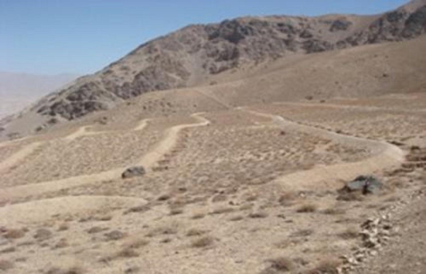
คำอธิบาย:
The Contour Trench Bund technology is documented by Sustainable Land Management
Project/HELVETAS Swiss Intercooperation with financial support of Swiss Agency for
Development and Cooperation(SDC) and close support and cooperation of the Catholic
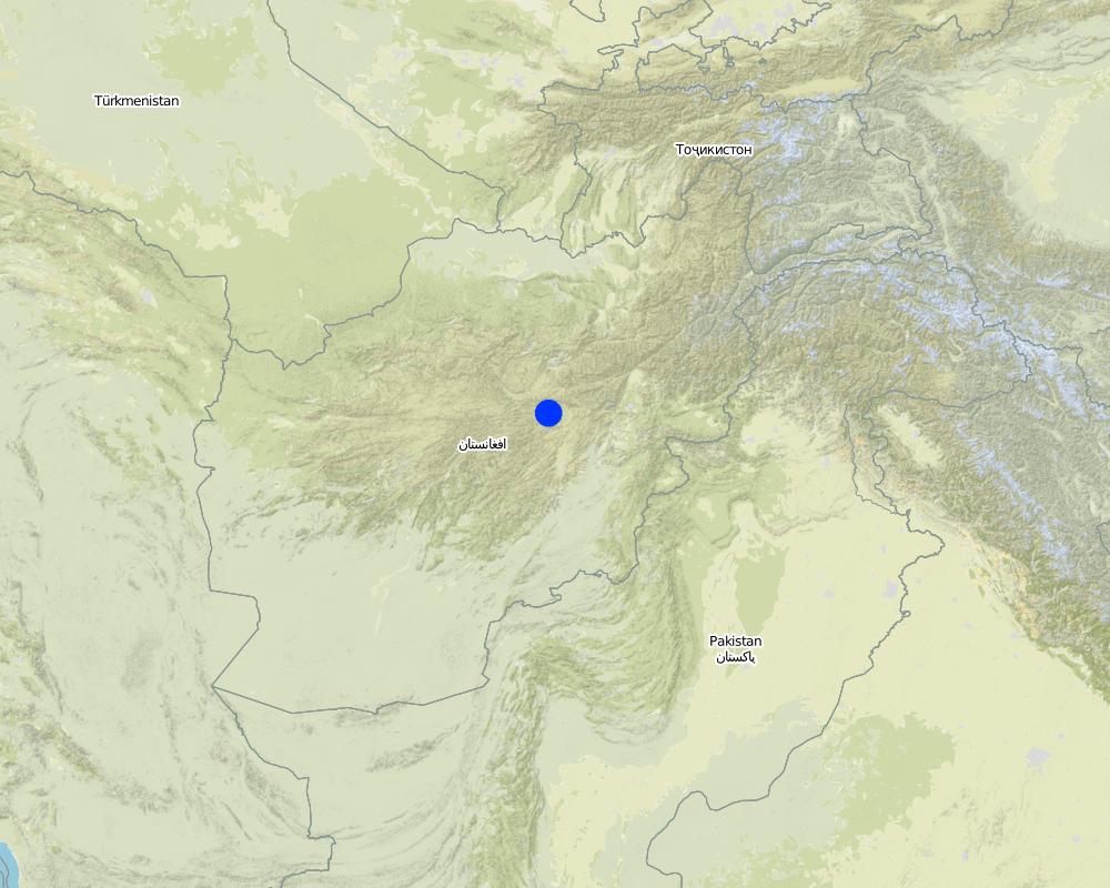
Relief Service (CRS). The technology was applied in Sar-e Ahengaran watershed of Bamyan centre, an area of 0.08 km2 as part of a watershed project by the Catholic Relief Services (CRS). The total watershed area is 67 ha. The project started in October 2009 involving the community with funding support from USAID and CRS. The project came to an end in March 2013.
Purpose of the Technology: The main purpose of the contour trench bund technology is to reduce excessive surface runoff and improve infiltration. It also contributes to increased vegetation cover.
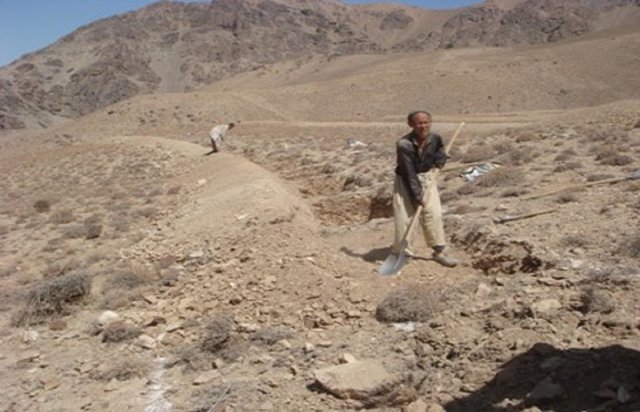
Establishment / maintenance activities and inputs: The main activities for this SLM technology include: site selection and technical planning in October 2009; demarcation of contour lines using A-frame and lime; and digging trenches and construction of soil bunds. The technology was established over 10 months. The project used a “Cash for Work” approach; local people were employed for construction works. Cost-wise, approximately 7,536 USD were spent on this technology (approximately 942 USD/ha) with 90% contribution from the project and 10% from the participating community. There have been no maintenance costs so far for this technology.
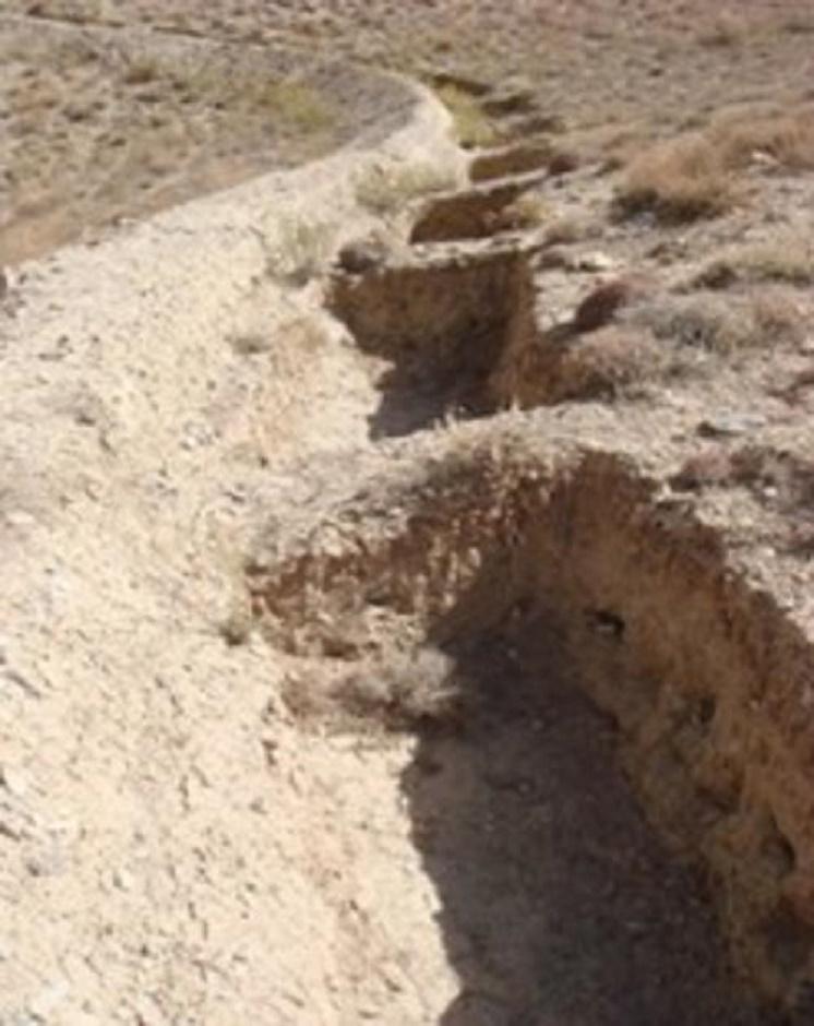
Dimensions of a trenches are: 0.7 m in depth, 1.2 m width, 3 m length and of the bunds: 0.45 m in height, 1.2 m in width, 100 m in length with 12 m spacing and 1.5 m vertical interval between two contour lines. Contour trenches were applied on hilly (16-30%) slopes at an altitude of 2500-3000 m. The technology is tolerant to temperature, seasonal rainfall, storms and droughts and sensitive to heavy rainfall events and floods. The soil in the watershed is sandy to loamy type, and infertile with a depth of 20-50 cm. The infiltration is medium.
The technology is part of the watershed management system. Other measures implemented included stone walls, cultivation of fodder grasses and ban on grazing and shrub cutting at the site. The land ownership (in the watershed) is communal with open access water rights. Medium scale land users, mainly men, applied the technology. Women and school children participated in meetings concerning awareness raising. There is also a watershed and pasture management committee for site management.
Natural / human environment: The annual rainfall in the area is 250-500 mm. The agro-climate is semi-arid and temperate type with the longest growing period of 180 days from April to October. The people in this area are mainly poor. 10-50 % of all income comes from off-farm activities. Access to health, market and financial services is low and education, roads, transport, drinking water and sanitation facilities are moderate. Agriculture is of mixed type, subsistence and commercial based.
2.3 รูปภาพของเทคโนโลยี
อัลบั้มสื่อบันทึก
2.5 ประเทศภูมิภาค หรือสถานที่ตั้งที่เทคโนโลยีได้นำไปใช้และได้รับการครอบคลุมโดยการประเมินนี้
ประเทศ:
อัฟกานิสถาน
ภูมิภาค/รัฐ/จังหวัด:
Sar_e_Ahangaran, Bamyan center
Map
×2.6 วันที่การดำเนินการ
ถ้าไม่รู้ปีที่แน่นอน ให้ระบุวันที่โดยประมาณ:
- น้อยกว่า 10 ปี (ไม่นานนี้)
2.7 คำแนะนำของเทคโนโลยี
ให้ระบุว่าเทคโนโลยีถูกแนะนำเข้ามาอย่างไร:
- ทางโครงการหรือจากภายนอก
3. การจัดประเภทของเทคโนโลยี SLM
3.1 วัตถุประสงค์หลักของเทคโนโลยี
- ป้องกันพื้นที่ลุ่มน้ำ/บริเวณท้ายน้ำ โดยร่วมกับเทคโนโลยีอื่นๆ
- ลดความเสี่ยงของภัยพิบัติ
3.2 ประเภทของการใช้ที่ดินในปัจจุบันที่ได้นำเทคโนโลยีไปใช้

ทุ่งหญ้าเลี้ยงสัตว์
ทุ่งหญ้าเลี้ยงสัตว์ที่ใช้พื้นที่กว้าง:
- กึ่งเร่ร่อน / อาจมีการทำทุ่งหญ้าเลี้ยงสัตว์ร่วมด้วย (Semi-nomadism/ pastoralism)
ชนิดพันธุ์สัตว์และผลิตภัณฑ์หลัก:
Sheeps, goats and cattle
แสดงความคิดเห็น:
Major land use problems (compiler’s opinion): Reduction of the vegetation cover causes flash floods and accelerated erosion. The water level goes down and there is no moisture in the soil.
Major land use problems (land users’ perception): Downstream flash flood and shortage of spring water due to overgrazing of the range-land.
Future (final) land use (after implementation of SLM Technology): Grazing land: Gi: Intensive grazing/ fodder production
ถ้าการใช้ที่ดินมีการเปลี่ยนแปลงเนื่องมาจากการนำเทคโนโลยีไปปฏิบัติใช้ ให้ระบุการใช้ที่ดินก่อนนำเทคโนโลยีไปปฏิบัติใช้:
Grazing land: Ge: Extensive grazing land
3.3 ข้อมูลเพิ่มเติมเกี่ยวกับการใช้ที่ดิน
การใช้น้ำของที่ดินที่มีการใช้เทคโนโลยีอยู่:
- น้ำฝนร่วมกับการชลประทาน
จำนวนของฤดูเพาะปลูกต่อปี:
- 1
ระบุ:
Longest growing period in days: 180; Longest growing period from month to month: April to October
ความหนาแน่นของปศุสัตว์ (ถ้าเกี่ยวข้อง):
10-25 LU /km2
3.4 กลุ่ม SLM ที่ตรงกับเทคโนโลยีนี้
- การปรับปรุงดิน / พืชคลุมดิน
- มาตรการปลูกพืชขวางความลาดชัน (cross-slope measure)
3.5 กระจายตัวของเทคโนโลยี
แสดงความคิดเห็น:
Total area covered by the SLM Technology is 0.08 km2.
3.6 มาตรการ SLM ที่ประกอบกันเป็นเทคโนโลยี

มาตรการอนุรักษ์ด้วยโครงสร้าง
- S2: ทำนบ เขื่อนดิน
- S4: คูน้ำแนวระดับ หลุม
แสดงความคิดเห็น:
Main measures: structural measures
3.7 รูปแบบหลักของการเสื่อมโทรมของที่ดินที่ได้รับการแก้ไขโดยเทคโนโลยี

การกัดกร่อนของดินโดยน้ำ
- Wt (Loss of topsoil): การสูญเสียดินชั้นบนหรือการกัดกร่อนที่ผิวดิน
แสดงความคิดเห็น:
Main causes of degradation: over-exploitation of vegetation for domestic use, overgrazing
3.8 การป้องกัน การลดลง หรือการฟื้นฟูความเสื่อมโทรมของที่ดิน
ระบุเป้าหมายของเทคโนโลยีกับความเสื่อมโทรมของที่ดิน:
- ลดความเสื่อมโทรมของดิน
4. ข้อมูลจำเพาะด้านเทคนิค กิจกรรมการนำไปปฏิบัติใช้ ปัจจัยนำเข้า และค่าใช้จ่าย
4.1 แบบแปลนทางเทคนิคของเทคโนโลยี
ผู้เขียน:
Mustafa Ershad
4.2 ข้อมูลจำเพาะด้านเทคนิคและการอธิบายแบบแปลนทางเทคนิค
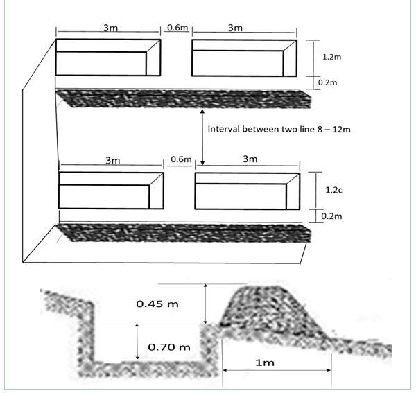
The technical drawing of the Contour trench bund showing the layout and dimensions/spacing of the structures.
Dimensions of the trench and bund are as following:
Trench specifications:
Depth: 0.7 m,
Width: 1.2 m, Length: 3 m
Soil bund specifications:
Height: 0.45 m
Width: 1.2 m
Length: 100 m
Spacing between contour lines:
About 8 -12 m (depend on slop)
Vertical interval:
1.5 m
Technical knowledge required for field staff / advisors: moderate
Technical knowledge required for land users: moderate
Main technical functions: control of raindrop splash, control of dispersed runoff: retain / trap, increase of infiltration
Secondary technical functions: reduction of slope length, increase of groundwater level / recharge of groundwater, sediment retention / trapping, sediment harvesting
4.3 ข้อมูลทั่วไปเกี่ยวกับการคำนวณปัจจัยนำเข้าและค่าใช้จ่าย
ระบุสกุลเงินที่ใช้คำนวณค่าใช้จ่าย:
- ดอลลาร์สหรัฐ
4.4 กิจกรรมเพื่อการจัดตั้ง
| กิจกรรม | ประเภทของมาตรการ | ช่วงเวลาดำเนินการ | |
|---|---|---|---|
| 1. | Demarcation of the contour lines using A frame and Lime | ด้วยโครงสร้าง | |
| 2. | Excavation of the trenches and construction of the soil bunds | ด้วยโครงสร้าง |
4.5 ค่าใช้จ่ายของปัจจัยนำเข้าที่จำเป็นสำหรับการจัดตั้ง
| ปัจจัยนำเข้า | หน่วย | ปริมาณ | ค่าใช้จ่ายต่อหน่วย | ค่าใช้จ่ายทั้งหมดต่อปัจจัยนำเข้า | %ของค่าใช้จ่ายที่ก่อให้เกิดขึ้นโดยผู้ใช้ที่ดิน | |
|---|---|---|---|---|---|---|
| แรงงาน | Demarcation of the contour lines | ha | 1.0 | 92.0 | 92.0 | |
| แรงงาน | Excavation of the trenches and construction of the soil bunds | persons/day/ha | 121.0 | 7.0 | 847.0 | 10.0 |
| ค่าใช้จ่ายทั้งหมดของการจัดตั้งเทคโนโลยี | 939.0 | |||||
แสดงความคิดเห็น:
Duration of establishment phase: 10 month(s)
4.6 การบำรุงรักษาสภาพหรือกิจกรรมที่เกิดขึ้นเป็นประจำ
| กิจกรรม | ประเภทของมาตรการ | ช่วงระยะเวลา/ความถี่ | |
|---|---|---|---|
| 1. | No maintenance costs so far for CRS. | ด้วยโครงสร้าง |
4.8 ปัจจัยสำคัญที่สุดที่มีผลกระทบต่อค่าใช้จ่าย
ปัจจัยสำคัญที่สุดที่มีผลกระทบต่อค่าใช้จ่ายต่างๆ:
The establishment duration of the Contour Trench Bund was 10 months.
5. สิ่งแวดล้อมทางธรรมชาติและของมนุษย์
5.1 ภูมิอากาศ
ฝนประจำปี
- < 250 ม.ม.
- 251-500 ม.ม.
- 501-750 ม.ม.
- 751-1,000 ม.ม.
- 1,001-1,500 ม.ม.
- 1,501-2,000 ม.ม.
- 2,001-3,000 ม.ม.
- 3,001-4,000 ม.ม.
- > 4,000 ม.ม.
เขตภูมิอากาศเกษตร
- กึ่งแห้งแล้ง
Thermal climate class: Temperate
5.2 สภาพภูมิประเทศ
ค่าเฉลี่ยความลาดชัน:
- ราบเรียบ (0-2%)
- ลาดที่ไม่ชัน (3-5%)
- ปานกลาง (6-10%)
- เป็นลูกคลื่น (11-15%)
- เป็นเนิน (16-30%)
- ชัน (31-60%)
- ชันมาก (>60%)
ธรณีสัณฐาน:
- ที่ราบสูง/ที่ราบ
- สันเขา
- ไหล่เขา
- ไหล่เนินเขา
- ตีนเนิน
- หุบเขา
ระดับความสูง:
- 0-100 เมตร
- 101-500 เมตร
- 501-1,000 เมตร
- 1,001-1,500 เมตร
- 1,501-2,000 เมตร
- 2,001-2,500 เมตร
- 2,501-3,000 เมตร
- 3,001-4,000 เมตร
- > 4,000 เมตร
5.3 ดิน
ค่าเฉลี่ยความลึกของดิน:
- ตื้นมาก (0-20 ซ.ม.)
- ตื้น (21-50 ซ.ม.)
- ลึกปานกลาง (51-80 ซ.ม.)
- ลึก (81-120 ซ.ม.)
- ลึกมาก (>120 ซ.ม.)
เนื้อดิน (ดินชั้นบน):
- หยาบ/เบา (ดินทราย)
- ปานกลาง (ดินร่วน ทรายแป้ง)
อินทรียวัตถุในดิน:
- ต่ำ (<1%)
(ถ้ามี) ให้แนบคำอธิบายเรื่องดินแบบเต็มหรือระบุข้อมูลที่มีอยู่ เช่น ชนิดของดิน ค่า pH ของดินหรือความเป็นกรดของดิน ความสามารถในการแลกเปลี่ยนประจุบวก ไนโตรเจน ความเค็ม เป็นต้น:
Soil fertility is low - medium
Soil drainage / infiltration is medium
Soil water storage capacity is medium
5.4 ความเป็นประโยชน์และคุณภาพของน้ำ
ระดับน้ำใต้ดิน:
5-50 เมตร
น้ำไหลบ่าที่ผิวดิน:
ไม่ดีหรือไม่มีเลย
คุณภาพน้ำ (ที่ยังไม่ได้บำบัด):
เป็นน้ำเพื่อการดื่มที่ดี
5.5 ความหลากหลายทางชีวภาพ
ความหลากหลายทางชนิดพันธุ์:
- ปานกลาง
5.6 ลักษณะของผู้ใช้ที่ดินที่นำเทคโนโลยีไปปฏิบัติใช้
แนวทางการตลาดของระบบการผลิต:
- ผสม (การเลี้ยงชีพ/ทำการค้า)
รายได้ที่มาจากนอกฟาร์ม:
- 10-50% ของรายได้ทั้งหมด
ระดับของความมั่งคั่งโดยเปรียบเทียบ:
- จน
เป็นรายบุคคล/ครัวเรือน:
- กลุ่ม/ชุมชน
เพศ:
- ชาย
ระบุลักษณะอื่นๆที่เกี่ยวข้องของผู้ใช้ที่ดิน:
Difference in the involvement of women and men: Workload does not give chance to women to work on the mountains.
Population density: < 10 persons/km2
Annual population growth: 2% - 3%
50% of the land users are poor.
Off-farm income specification: Busy with carpentry and migrate for work.
5.7 พื้นที่เฉลี่ยของที่ดินที่เป็นเจ้าของหรือเช่าโดยผู้ใช้ที่ดินที่นำเทคโนโลยีไปปฏิบัติใช้
- < 0.5 เฮกตาร์
- 0.5-1 เฮกตาร์
- 1-2 เฮกตาร์
- 2-5 เฮกตาร์
- 5-15 เฮกตาร์
- 15-50 เฮกตาร์
- 50-100 เฮกตาร์
- 100-500 เฮกตาร์
- 500-1,000 เฮกตาร์
- 1,000-10,000 เฮกตาร์
- >10,000 เฮกตาร์
พิจารณาว่าเป็นขนาดเล็ก กลาง หรือขนาดใหญ่ (ซึ่งอ้างอิงถึงบริบทระดับท้องถิ่น):
- ขนาดกลาง
5.8 กรรมสิทธิ์ในที่ดิน สิทธิในการใช้ที่ดินและสิทธิในการใช้น้ำ
กรรมสิทธิ์ในที่ดิน:
- เป็นแบบชุมชนหรือหมู่บ้าน
สิทธิในการใช้ที่ดิน:
- เกี่ยวกับชุมชน (ถูกจัดระเบียบ)
สิทธิในการใช้น้ำ:
- เข้าถึงได้แบบเปิด (ไม่ได้จัดระเบียบ)
5.9 การเข้าถึงบริการและโครงสร้างพื้นฐาน
สุขภาพ:
- จน
- ปานกลาง
- ดี
การศึกษา:
- จน
- ปานกลาง
- ดี
ความช่วยเหลือทางด้านเทคนิค:
- จน
- ปานกลาง
- ดี
การจ้างงาน (เช่น ภายนอกฟาร์ม):
- จน
- ปานกลาง
- ดี
ตลาด:
- จน
- ปานกลาง
- ดี
พลังงาน:
- จน
- ปานกลาง
- ดี
ถนนและการขนส่ง:
- จน
- ปานกลาง
- ดี
น้ำดื่มและการสุขาภิบาล:
- จน
- ปานกลาง
- ดี
บริการด้านการเงิน:
- จน
- ปานกลาง
- ดี
6. ผลกระทบและสรุปคำบอกกล่าว
6.1 ผลกระทบในพื้นที่ดำเนินการ (On-site) จากการใช้เทคโนโลยี
ผลกระทบทางด้านเศรษฐกิจและสังคม
การผลิต
การผลิตพืชที่ใช้เลี้ยงปศุสัตว์
แสดงความคิดเห็น/ระบุ:
Due to better soil moisture
รายได้และค่าใช้จ่าย
ความหลากหลายของแหล่งผลิตรายได้
ผลกระทบด้านสังคมวัฒนธรรมอื่น ๆ
SLM หรือความรู้เรื่องความเสื่อมโทรมของที่ดิน
สถานการณ์ของกลุ่มด้อยโอกาส ทางด้านสังคมและเศรษฐกิจ
livelihood and human well-being
แสดงความคิดเห็น/ระบุ:
Due to reduction in flash floods problem and increased access to drinking water, Seasonal job opportunities created through cash for work
ผลกระทบด้านนิเวศวิทยา
วัฐจักรน้ำหรือน้ำบ่า
การเก็บเกี่ยวหรือการกักเก็บน้ำ
แสดงความคิดเห็น/ระบุ:
of surface run off
น้ำบาดาลหรือระดับน้ำในแอ่งน้ำบาดาล
ดิน
ความชื้นในดิน
การสูญเสียดิน
ความหลากหลายทางชีวภาพของพืชและสัตว์
มวลชีวภาพ/เหนือดินชั้น C
แสดงความคิดเห็น/ระบุ:
Due to more moisture
ลดความเสี่ยงของภัยพิบัติ
ผลกระทบจากน้ำท่วม
ผลกระทบด้านนิเวศวิทยาอื่น ๆ
disturbance of soil and vegetation during excavation works
6.2 ผลกระทบนอกพื้นที่ดำเนินการ (Off-site) จากการใช้เทคโนโลยี
น้ำที่ใช้ประโยชน์ได้
น้ำท่วมพื้นที่ท้ายน้ำ
การทับถมของดินตะกอนพื้นที่ท้ายน้ำ
แสดงความคิดเห็น/ระบุ:
And sedimentation
damage on agriculture fields
As the site is closed, grazing pressure shifts elsewhere
6.3 การเผชิญและความตอบสนองของเทคโนโลยีต่อการเปลี่ยนแปลงสภาพภูมิอากาศที่ค่อยเป็นค่อยไป และสภาพรุนแรงของภูมิอากาศ / ภัยพิบัติ (ที่รับรู้ได้โดยผู้ใช้ที่ดิน)
การเปลี่ยนแปลงสภาพภูมิอากาศที่ค่อยเป็นค่อยไป
การเปลี่ยนแปลงสภาพภูมิอากาศที่ค่อยเป็นค่อยไป
| ฤดู | ประเภทของการเปลี่ยนแปลงสภาพภูมิอากาศที่ค่อยเป็นค่อยไป และสภาพรุนแรงของภูมิอากาศ | เทคโนโลยีมีวิธีการรับมืออย่างไร | |
|---|---|---|---|
| อุณหภูมิประจำปี | เพิ่มขึ้น | ดี |
สภาพรุนแรงของภูมิอากาศ (ภัยพิบัติ)
ภัยพิบัติทางอุตุนิยมวิทยา
| เทคโนโลยีมีวิธีการรับมืออย่างไร | |
|---|---|
| พายุลมประจำท้องถิ่น | ดี |
ภัยพิบัติจากสภาพภูมิอากาศ
| เทคโนโลยีมีวิธีการรับมืออย่างไร | |
|---|---|
| ภัยจากฝนแล้ง | ดี |
ผลลัพธ์ตามมาที่เกี่ยวข้องกับภูมิอากาศอื่น ๆ
ผลลัพธ์ตามมาที่เกี่ยวข้องกับภูมิอากาศอื่น ๆ
| เทคโนโลยีมีวิธีการรับมืออย่างไร | |
|---|---|
| Extreme precipitation events especially if the technology is applied on steep slopes. | ไม่ค่อยดี |
แสดงความคิดเห็น:
Increase size, stable bunds stabilized with vegetation
6.4 การวิเคราะห์ค่าใช้จ่ายและผลประโยชน์ที่ได้รับ
ผลประโยชน์ที่ได้รับเปรียบเทียบกับค่าใช้จ่ายในการจัดตั้งเป็นอย่างไร (จากมุมมองของผู้ใช้ที่ดิน)
ผลตอบแทนระยะสั้น:
ด้านลบเล็กน้อย
ผลตอบแทนระยะยาว:
ด้านบวก
ผลประโยชน์ที่ได้รับเปรียบเทียบกับค่าใช้จ่ายในการบำรุงรักษาหรือต้นทุนที่เกิดขึ้นซ้ำอีก เป็นอย่างไร (จากมุมมองของผู้ใช้ที่ดิน)
ผลตอบแทนระยะสั้น:
เป็นกลางหรือสมดุล
ผลตอบแทนระยะยาว:
ด้านบวกอย่างมาก
แสดงความคิดเห็น:
The benefits will be more in the long term when trees, shrubs and fodder grasses are ready to harvest.
6.5 การปรับตัวของเทคโนโลยี
แสดงความคิดเห็น:
Comments on acceptance with external material support: Appropriate information is not available.
Comments on spontaneous adoption: Only soil bunds have been applied by a few farmers on their private lands.
6.7 จุดแข็ง / ข้อได้เปรียบ / โอกาสของเทคโนโลยี
| จุดแข็ง / ข้อได้เปรียบ / โอกาสในทัศนคติของผู้ใช้ที่ดิน |
|---|
|
The technology helps to create SLM based job opportunities for many people. How can they be sustained / enhanced? Needs external support/projects. |
| จุดแข็ง / ข้อได้เปรียบ / โอกาสในทัศนคติของผู้รวบรวมหรือวิทยากรหลัก |
|---|
|
Demonstration of link between SLM measures and water source. How can they be sustained / enhanced? Conducting training and showing drawing. |
|
Technical knowledge of community enhanced. How can they be sustained / enhanced? Share more aspects of the technology, where to apply and how. |
|
Flood reduction, greening of the area, increase the spring water. How can they be sustained / enhanced? Cultivate native plants, share experiences with more communities and SLM specialists. |
|
Good for land rehabilitation (extremely degraded lands). How can they be sustained / enhanced? Always combine with vegetative and management measures. |
6.8 จุดอ่อน / ข้อเสียเปรียบ / ความเสี่ยงของเทคโนโลยีและวิธีการแก้ไข
| จุดอ่อน / ข้อเสียเปรียบ / ความเสี่ยงในทัศนคติของผู้ใช้ที่ดิน | มีวิธีการแก้ไขได้อย่างไร |
|---|---|
| Farmers do not prefer to construct this technology because it requires soil excavation/disturbance. | One needs to show how such measures have been applied in other parts of the world for multiple benefits through action research. |
| จุดอ่อน / ข้อเสียเปรียบ / ความเสี่ยงในทัศนคติของผู้รวบรวมหรือวิทยากรหลัก | มีวิธีการแก้ไขได้อย่างไร |
|---|---|
| Site selection | Apply technology at suitable site that has proper slope and is really degraded. Avoid places where there is already good vegetation cover. |
| Higher cost of establishment of the technology. | Encourage the community for more contribution or apply where absolutely necessary. |
| Technical design | The designer should research more about the site and discuss with the skilled people of the community before designing. |
| Few vegetative measures | plant fodder grasses and adapted trees between trenches. |
ลิงก์และโมดูล
ขยายทั้งหมด ย่อทั้งหมดลิงก์
Community-Based Watershed Management [อัฟกานิสถาน]
Sustainable implementation of watershed management through appropriate SLM technologies, formation of organizational structures and capacity building of stakeholders
- ผู้รวบรวม: Aqila Haidery
โมดูล
ไม่มีโมดูล