Cultivation of Hing (Ferula assa-foetida) in the watershed [อัฟกานิสถาน]
- ผู้สร้างสรรค์:
- การอัพเดท:
- ผู้รวบรวม: Aqila Haidery
- ผู้เรียบเรียง: –
- ผู้ตรวจสอบ: Alexandra Gavilano
Kesht Angoza da abriza
technologies_1306 - อัฟกานิสถาน
ดูส่วนย่อย
ขยายทั้งหมด ย่อทั้งหมด1. ข้อมูลทั่วไป
1.2 รายละเอียดที่ติดต่อได้ของผู้รวบรวมและองค์กรที่เกี่ยวข้องในการประเมินและการจัดเตรียมทำเอกสารของเทคโนโลยี
ผู้เชี่ยวชาญ SLM:
ชื่อขององค์กรซึ่งอำนวยความสะดวกในการทำเอกสารหรือการประเมินเทคโนโลยี (ถ้าเกี่ยวข้อง)
HELVETAS (Swiss Intercooperation)1.3 เงื่อนไขการใช้ข้อมูลที่ได้บันทึกผ่านทาง WOCAT
ผู้รวบรวมและวิทยากรหลักยอมรับเงื่อนไขเกี่ยวกับการใช้ข้อมูลที่ถูกบันทึกผ่านทาง WOCAT:
ใช่
1.4 การเปิดเผยเรื่องความยั่งยืนของเทคโนโลยีที่ได้อธิบายไว้
เทคโนโลยีที่ได้อธิบายไว้นี้เป็นปัญหาของความเสื่อมโทรมโทรมของที่ดินหรือไม่ จึงไม่ได้รับการยอมรับว่าเป็นเทคโนโลยีเพื่อการจัดการที่ดินอย่างยั่งยืน:
ไม่ใช่
2. การอธิบายลักษณะของเทคโนโลยี SLM
2.1 การอธิบายแบบสั้น ๆ ของเทคโนโลยี
คำจำกัดความของเทคโนโลยี:
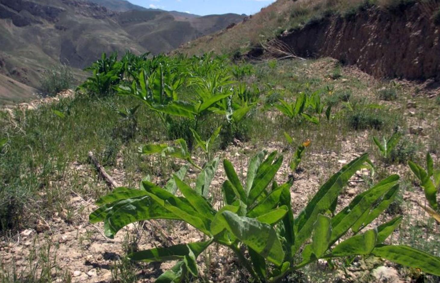
Ferula assa-foetida is an important medicinal plant, a valued cash crop and a native plant of Afghanistan’s range-lands.
2.2 การอธิบายแบบละเอียดของเทคโนโลยี
คำอธิบาย:
Cultivation of hing (Ferula assa-foetida) in watersheds is documented by the Sustainable Land Management Project which is implemented by HELVETAS Swiss Intercooperation and funded by the Swiss Agency for Development and Cooperation (SDC). Ferula assa-foetida, or hing, is a medicinal plant that grows well in shallow sandy and alkaline soils in semi-arid climates and at high altitudes and is a native plant of Afghanistan’s upper catchment areas. Due to the enduring conflict and the consequent breakdown of community-managed grazing in upper catchment areas, most range-lands in Afghanistan are been seriously degraded. Uncontrolled grazing of animals and growing cereal crops on range-lands are the main contributors to the loss of vegetation coverage in upper catchments. One of the negative consequences are flash floods occurring several times a year, damaging agricultural lands, irrigation canals, houses and other infrastructure while often also causing fatalities.
In order to decrease the risk of flash floods, improve pastures and extend cash crop cultivation in upper catchment areas, HELVETAS Swiss Intercooperation has implemented community-based watershed activities such as structural and agronomic measures to control water runoff.
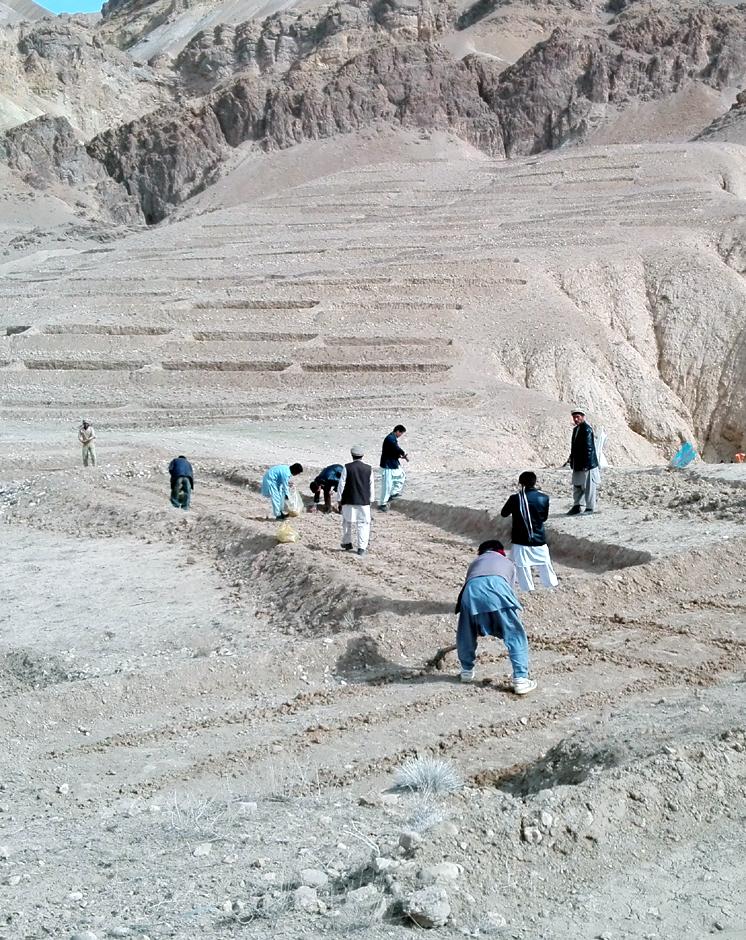
Hing has been identified as a suitable agronomic measure in watershed management in Saighan district. HELVETAS Swiss Intercooperation and the target communities selected hing as a valuable cash crop and a suitable plant for watershed rehabilitation. Today, hing is cultivated on 1,400,000 m2 (140 ha) in nine watersheds and with the participation of 1500 families. The growing period of hing depends on the local climate but tends to be 5-10 years and culminates in the pants’ flowering. During the first five years hing has grey colored leaves. Later a stem appears and grows more than a meter high. The stem is large and yellow and at the end of the main and subordinate stems are yellow flowers. The width of the hing root varies between 7-15 cm and usually goes as deep as 30-40 cm into the soil. Hing plantations have been established with the involvement of the local communities and are managed by the responsible watershed committee. The harvest of hing is organized by the watershed committee and all households have the right to participate and sell hing for income generation. To maintain watershed activities, such as hing cultivation, a safe box has been created for each community-managed watershed. The watershed committee manages the safe box and collects funds for maintenance, community development and emergency projects, according to the watershed management plan which has been developed by the local communities with support of HELVETAS Swiss Intercooperation.
Natural / human environment: Bamyan is a remote province of Afghanistan with a high poverty rate. It has a semi-arid climate with cold winters and hot and dry summers. During winter, temperatures can drop below -22 degrees. Summer temperatures can reach to 34 degrees in the month of July. The average annual rainfall in the area is about 230 mm and some years can be very dry. 90% of the population relies on subsistence agriculture for their livelihoods and off-farm activities are marginal. The growing season in Saighan district is relatively short from April to October and farmers can produce only one crop per year. Farmers with access to irrigation water cultivate cash crops, for example potato and vegetables, in addition to staple (wheat) and fodder crops. Those without access to irrigation water cultivate wheat and fodder crops only. Water scarcity from May to September may result in a lack of high value crops.
2.3 รูปภาพของเทคโนโลยี
อัลบั้มสื่อบันทึก
2.5 ประเทศภูมิภาค หรือสถานที่ตั้งที่เทคโนโลยีได้นำไปใช้และได้รับการครอบคลุมโดยการประเมินนี้
ประเทศ:
อัฟกานิสถาน
ภูมิภาค/รัฐ/จังหวัด:
Bamyan
ข้อมูลจำเพาะเพิ่มเติมของสถานที่ตั้ง :
Saighan
ระบุการกระจายตัวของเทคโนโลยี:
- กระจายไปอย่างสม่ำเสมอในพื้นที่
If the Technology is evenly spread over an area, specify area covered (in km2):
1.4
If precise area is not known, indicate approximate area covered:
- 1-10 ตร.กม.
2.6 วันที่การดำเนินการ
ถ้าไม่รู้ปีที่แน่นอน ให้ระบุวันที่โดยประมาณ:
- น้อยกว่า 10 ปี (ไม่นานนี้)
2.7 คำแนะนำของเทคโนโลยี
- Re-introduction
ความคิดเห็น (ประเภทของโครงการ เป็นต้น) :
The technology was introduced since 2012
3. การจัดประเภทของเทคโนโลยี SLM
3.1 วัตถุประสงค์หลักของเทคโนโลยี
- ลด ป้องกัน ฟื้นฟู การเสื่อมโทรมของที่ดิน
- สร้างผลกระทบทางด้านเศรษฐกิจที่เป็นประโยชน์
3.2 ประเภทของการใช้ที่ดินในปัจจุบันที่ได้นำเทคโนโลยีไปใช้
Land use mixed within the same land unit:
ใช่
Specify mixed land use (crops/ grazing/ trees):
- Agro-pastoralism (incl. integrated crop-livestock)

พื้นที่ปลูกพืช
- การปลูกพืชยืนต้นที่ไม่มีเนื้อไม้
Perennial (non-woody) cropping - Specify crops:
- medicinal, aromatic, pesticidal plants - perennial

ทุ่งหญ้าเลี้ยงสัตว์
Extensive grazing:
- กึ่งโนแมนดิซึ่มหรือแพสโตแรลลิซึ่ม (Semi-nomadism/pastoralism)
ทุ่งหญ้าเลี้ยงสัตว์ที่มีการจัดการแบบเข้มข้นหรือการผลิตอาหารสัตว์:
- ตัดแล้วขนไป / ไม่มีการปล่อยแทะเล็มเอง (Cut-and-carry / zero grazing)
แสดงความคิดเห็น:
Major land use problems (compiler’s opinion): Lack of management in upper catchment area over the last decades resulted in a severe loss of vegetation and in the loss of biodiversity. Uncontrolled grazing of animals during the spring season prevented seed production of domestic plants. Hot temperature in summer burnt the remaining parts of domestic plants. Each year, the soil is washed away by heavy rainfalls creating gulleys which further reduced the vegetation cover.
Major land use problems (land users’ perception): The users of watershed areas cut shrubs for fuel and graze their animals. The lack of alternatives left them to overuse resources in upper catchment areas during war and conflict.
Future (final) land use (after implementation of SLM Technology): Cropland: Cp: Perennial (non-woody) cropping
Number of growing seasons per year: 1
Longest growing period in days: 120, Longest growing period from month to month: March to July
Livestock density: 10-25 LU /km2
3.3 Has land use changed due to the implementation of the Technology?
Has land use changed due to the implementation of the Technology?
- Yes (Please fill out the questions below with regard to the land use before implementation of the Technology)
Land use mixed within the same land unit:
ไม่ใช่
ทุ่งหญ้าเลี้ยงสัตว์
- Extensive grazing
3.4 การใช้น้ำ
การใช้น้ำของที่ดินที่มีการใช้เทคโนโลยีอยู่:
- จากน้ำฝน
3.5 กลุ่ม SLM ที่ตรงกับเทคโนโลยีนี้
- cultivation of medical plants
3.6 มาตรการ SLM ที่ประกอบกันเป็นเทคโนโลยี

มาตรการจัดการพืช
- A1: พืช/สิ่งปกคลุมดิน
แสดงความคิดเห็น:
Type of agronomic measures: better crop cover, mixed cropping / intercropping, cover cropping
3.7 รูปแบบหลักของการเสื่อมโทรมของที่ดินที่ได้รับการแก้ไขโดยเทคโนโลยี

การกัดกร่อนของดินโดยน้ำ
- Wt (Loss of topsoil): การสูญเสียดินชั้นบนหรือการกัดกร่อนที่ผิวดิน
แสดงความคิดเห็น:
Main causes of degradation: crop management (annual, perennial, tree/shrub) (The upper catchment area have broken to agricultural lands), deforestation / removal of natural vegetation (incl. forest fires) (Domestic shrubs have been cut and have been used for fuel energy), overgrazing (Without management people grazed their animals in spring season and prevented from the plant seed production.), war and conflicts (3 decades internal wars in Afghanistan)
Secondary causes of degradation: droughts (Continiuosly 3 drought years also had a rule for burning plants in upper catchment areas), poverty / wealth (During internal wars, people were not able to go in other provinces and only they had access to agriculture land and livestock for their livelihood)
3.8 การป้องกัน การลดลง หรือการฟื้นฟูความเสื่อมโทรมของที่ดิน
ระบุเป้าหมายของเทคโนโลยีกับความเสื่อมโทรมของที่ดิน:
- ฟื้นฟูบำบัดที่ดินที่เสื่อมโทรมลงอย่างมาก
4. ข้อมูลจำเพาะด้านเทคนิค กิจกรรมการนำไปปฏิบัติใช้ ปัจจัยนำเข้า และค่าใช้จ่าย
4.1 แบบแปลนทางเทคนิคของเทคโนโลยี
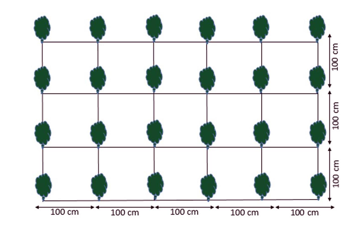
ข้อมูลจำเพาะด้านเทคนิค (แบบแปลนทางเทคนิคของเทคโนโลยี):
Cultivation plan of Ferula assa-foetida:
Plant to plant distance 100 cm.
Line to line distance 100 cm.
Seed depth 1-1.5 cm with;
3-6 seeds in one spot.
Location: Saighan watersheds. Bamyan
Date: 18/04/2016
Technical knowledge required for field staff / advisors: high
Technical knowledge required for land users: moderate
Main technical functions: control of raindrop splash, improvement of surface structure (crusting, sealing), increase of infiltration, Increase vegetation cover through cash crop
Better crop cover
Material/ species: Ferula assa-foetida
Quantity/ density: 4 plant/m2
Remarks: plant to plant and line to line 100 cm
Mixed cropping / intercropping
Material/ species: Ferula assa-foetida and other domestic plants
Quantity/ density: 1 m2
Remarks: Growing domestic plants between Ferula assa-foetida plants
Cover cropping
Material/ species: Ferula assa-foetida and other plants cover the naked area
ผู้เขียน:
Shabir Shahem, HELVETAS Swiss Intercooperation, Afghanistan
4.2 ข้อมูลทั่วไปเกี่ยวกับการคำนวณปัจจัยนำเข้าและค่าใช้จ่าย
อื่นๆ หรือสกุลเงินประจำชาติ (ระบุ):
Afghani
If relevant, indicate exchange rate from USD to local currency (e.g. 1 USD = 79.9 Brazilian Real): 1 USD =:
67.69
ระบุค่าเฉลี่ยของค่าจ้างในการจ้างแรงงานต่อวัน:
5.17
4.4 ค่าใช้จ่ายของปัจจัยนำเข้าที่จำเป็นสำหรับการจัดตั้ง
| ปัจจัยนำเข้า | หน่วย | ปริมาณ | ค่าใช้จ่ายต่อหน่วย | ค่าใช้จ่ายทั้งหมดต่อปัจจัยนำเข้า | %ของค่าใช้จ่ายที่ก่อให้เกิดขึ้นโดยผู้ใช้ที่ดิน | |
|---|---|---|---|---|---|---|
| แรงงาน | labour | ha | 1.0 | 12.92 | 12.92 | 25.0 |
| วัสดุด้านพืช | seeds | ha | 1.0 | 115.0 | 115.0 | 25.0 |
| ค่าใช้จ่ายทั้งหมดของการจัดตั้งเทคโนโลยี | 127.92 | |||||
| Total costs for establishment of the Technology in USD | 1.89 | |||||
4.5 การบำรุงรักษาสภาพหรือกิจกรรมที่เกิดขึ้นเป็นประจำ
| กิจกรรม | ช่วงระยะเวลา/ความถี่ | |
|---|---|---|
| 1. | Hiring guard for protection of watershed from uncontrolled grazing |
4.6 ค่าใช้จ่ายของปัจจัยนำเข้าและกิจกรรมที่เกิดขึ้นเป็นประจำที่ต้องการการบำรุงรักษา (ต่อปี)
แสดงความคิดเห็น:
In 2015, the government of Tajikistan did not limit the export of seeds to Afghanistan.
4.7 ปัจจัยสำคัญที่สุดที่มีผลกระทบต่อค่าใช้จ่าย
ปัจจัยสำคัญที่สุดที่มีผลกระทบต่อค่าใช้จ่ายต่างๆ:
Good quality seeds are available in Tajikistan. If the government of Tajikistan limits exporting seeds to Afghanistan, seed costs may increase.
5. สิ่งแวดล้อมทางธรรมชาติและของมนุษย์
5.1 ภูมิอากาศ
ฝนประจำปี
- < 250 ม.ม.
- 251-500 ม.ม.
- 501-750 ม.ม.
- 751-1,000 ม.ม.
- 1,001-1,500 ม.ม.
- 1,501-2,000 ม.ม.
- 2,001-3,000 ม.ม.
- 3,001-4,000 ม.ม.
- > 4,000 ม.ม.
เขตภูมิอากาศเกษตร
- กึ่งแห้งแล้ง
Thermal climate class: temperate
5.2 สภาพภูมิประเทศ
ค่าเฉลี่ยความลาดชัน:
- ราบเรียบ (0-2%)
- ลาดที่ไม่ชัน (3-5%)
- ปานกลาง (6-10%)
- เป็นลูกคลื่น (11-15%)
- เป็นเนิน (16-30%)
- ชัน (31-60%)
- ชันมาก (>60%)
ธรณีสัณฐาน:
- ที่ราบสูง/ที่ราบ
- สันเขา
- ไหล่เขา
- ไหล่เนินเขา
- ตีนเนิน
- หุบเขา
ระดับความสูง:
- 0-100 เมตร
- 101-500 เมตร
- 501-1,000 เมตร
- 1,001-1,500 เมตร
- 1,501-2,000 เมตร
- 2,001-2,500 เมตร
- 2,501-3,000 เมตร
- 3,001-4,000 เมตร
- > 4,000 เมตร
5.3 ดิน
ค่าเฉลี่ยความลึกของดิน:
- ตื้นมาก (0-20 ซ.ม.)
- ตื้น (21-50 ซ.ม.)
- ลึกปานกลาง (51-80 ซ.ม.)
- ลึก (81-120 ซ.ม.)
- ลึกมาก (>120 ซ.ม.)
เนื้อดิน (ดินชั้นบน):
- ปานกลาง (ดินร่วน ทรายแป้ง)
อินทรียวัตถุในดิน:
- ต่ำ (<1%)
5.4 ความเป็นประโยชน์และคุณภาพของน้ำ
ระดับน้ำใต้ดิน:
5-50 เมตร
น้ำไหลบ่าที่ผิวดิน:
ไม่ดีหรือไม่มีเลย
คุณภาพน้ำ (ที่ยังไม่ได้บำบัด):
เป็นน้ำใช้เพื่อการเกษตรเท่านั้น (การชลประทาน)
5.5 ความหลากหลายทางชีวภาพ
ความหลากหลายทางชนิดพันธุ์:
- ต่ำ
5.6 ลักษณะของผู้ใช้ที่ดินที่นำเทคโนโลยีไปปฏิบัติใช้
รายได้ที่มาจากนอกฟาร์ม:
- < 10% ของรายได้ทั้งหมด
ระดับของความมั่งคั่งโดยเปรียบเทียบ:
- จน
- พอมีพอกิน
เป็นรายบุคคล/ครัวเรือน:
- กลุ่ม/ชุมชน
เพศ:
- หญิง
- ชาย
ระบุลักษณะอื่นๆที่เกี่ยวข้องของผู้ใช้ที่ดิน:
Land users applying the Technology are mainly common / average land users
Population density: 10-50 persons/km2
Annual population growth: 0.5% - 1%
10% of the land users are rich.
35% of the land users are average wealthy.
45% of the land users are poor.
Off-farm income specification: The importance of off-farm income is marginal. However, hing cultivation in the watershed presents a viable opportunity to generate income off-farm for the involved communities. Hing can contribute up to >50% of off-farm income.
The watershed belongs to the communities and all households have the same rights.
The income is saved in a communal safe box and is spent for community development and emergency issues.
5.7 Average area of land used by land users applying the Technology
- < 0.5 เฮกตาร์
- 0.5-1 เฮกตาร์
- 1-2 เฮกตาร์
- 2-5 เฮกตาร์
- 5-15 เฮกตาร์
- 15-50 เฮกตาร์
- 50-100 เฮกตาร์
- 100-500 เฮกตาร์
- 500-1,000 เฮกตาร์
- 1,000-10,000 เฮกตาร์
- >10,000 เฮกตาร์
พิจารณาว่าเป็นขนาดเล็ก กลาง หรือขนาดใหญ่ (ซึ่งอ้างอิงถึงบริบทระดับท้องถิ่น):
- ขนาดกลาง
5.8 กรรมสิทธิ์ในที่ดิน สิทธิในการใช้ที่ดินและสิทธิในการใช้น้ำ
กรรมสิทธิ์ในที่ดิน:
- เป็นแบบชุมชนหรือหมู่บ้าน
สิทธิในการใช้ที่ดิน:
- เกี่ยวกับชุมชน (ถูกจัดระเบียบ)
สิทธิในการใช้น้ำ:
- เกี่ยวกับชุมชน (ถูกจัดระเบียบ)
5.9 การเข้าถึงบริการและโครงสร้างพื้นฐาน
สุขภาพ:
- จน
- ปานกลาง
- ดี
การศึกษา:
- จน
- ปานกลาง
- ดี
ความช่วยเหลือทางด้านเทคนิค:
- จน
- ปานกลาง
- ดี
การจ้างงาน (เช่น ภายนอกฟาร์ม):
- จน
- ปานกลาง
- ดี
ตลาด:
- จน
- ปานกลาง
- ดี
พลังงาน:
- จน
- ปานกลาง
- ดี
ถนนและการขนส่ง:
- จน
- ปานกลาง
- ดี
น้ำดื่มและการสุขาภิบาล:
- จน
- ปานกลาง
- ดี
บริการด้านการเงิน:
- จน
- ปานกลาง
- ดี
6. ผลกระทบและสรุปคำบอกกล่าว
6.1 ผลกระทบในพื้นที่ดำเนินการ (On-site) จากการใช้เทคโนโลยี
ผลกระทบทางด้านเศรษฐกิจและสังคม
รายได้และค่าใช้จ่าย
รายได้จากฟาร์ม
ผลกระทบด้านสังคมวัฒนธรรมอื่น ๆ
สถาบันของชุมชน
แสดงความคิดเห็น/ระบุ:
Watershed committee manage the income of Ferula assa-foetida productions through safe box investment
contribution to human well-being
แสดงความคิดเห็น/ระบุ:
Improve the economic opportunities of the community to generate income
ผลกระทบด้านนิเวศวิทยา
วัฐจักรน้ำหรือน้ำบ่า
น้ำไหลบ่าที่ผิวดิน
จำนวนก่อน SLM:
5
หลังจาก SLM:
25
แสดงความคิดเห็น/ระบุ:
Vegetation coverage
ดิน
ความชื้นในดิน
จำนวนก่อน SLM:
10
หลังจาก SLM:
30
แสดงความคิดเห็น/ระบุ:
When the plants grow more, cover area and infilterate runoff
การสูญเสียดิน
จำนวนก่อน SLM:
5
หลังจาก SLM:
50
แสดงความคิดเห็น/ระบุ:
Vegetation coverage
ความหลากหลายทางชีวภาพของพืชและสัตว์
ชนิดพันธุ์ที่ให้ประโยชน์
6.2 ผลกระทบนอกพื้นที่ดำเนินการ (Off-site) จากการใช้เทคโนโลยี
น้ำท่วมพื้นที่ท้ายน้ำ
แสดงความคิดเห็น/ระบุ:
Vegetation coverage
ความเสียหายต่อพื้นที่เพาะปลูกของเพื่อนบ้าน
แสดงความคิดเห็น/ระบุ:
Reduction of flash flood protect lower part resources
ความเสียหายต่อโครงสร้างพื้นฐานของรัฐหรือของเอกชน
6.3 การเผชิญและความตอบสนองของเทคโนโลยีต่อการเปลี่ยนแปลงสภาพภูมิอากาศที่ค่อยเป็นค่อยไป และสภาพรุนแรงของภูมิอากาศ / ภัยพิบัติ (ที่รับรู้ได้โดยผู้ใช้ที่ดิน)
การเปลี่ยนแปลงสภาพภูมิอากาศที่ค่อยเป็นค่อยไป
การเปลี่ยนแปลงสภาพภูมิอากาศที่ค่อยเป็นค่อยไป
| ฤดู | increase or decrease | เทคโนโลยีมีวิธีการรับมืออย่างไร | |
|---|---|---|---|
| อุณหภูมิประจำปี | เพิ่มขึ้น | ดี |
สภาพรุนแรงของภูมิอากาศ (ภัยพิบัติ)
ภัยพิบัติทางอุตุนิยมวิทยา
| เทคโนโลยีมีวิธีการรับมืออย่างไร | |
|---|---|
| พายุฝนประจำท้องถิ่น | ไม่ค่อยดี |
| พายุลมประจำท้องถิ่น | ดี |
ภัยพิบัติจากน้ำ
| เทคโนโลยีมีวิธีการรับมืออย่างไร | |
|---|---|
| น้ำท่วมตามปกติ (แม่น้ำ) | ไม่ค่อยดี |
ผลลัพธ์ตามมาที่เกี่ยวข้องกับภูมิอากาศอื่น ๆ
ผลลัพธ์ตามมาที่เกี่ยวข้องกับภูมิอากาศอื่น ๆ
| เทคโนโลยีมีวิธีการรับมืออย่างไร | |
|---|---|
| ช่วงการปลูกพืชที่ลดลงมา | ไม่ทราบ |
แสดงความคิดเห็น:
Should be cultivated away from flood stream area.
6.4 การวิเคราะห์ค่าใช้จ่ายและผลประโยชน์ที่ได้รับ
ผลประโยชน์ที่ได้รับเปรียบเทียบกับค่าใช้จ่ายในการจัดตั้งเป็นอย่างไร (จากมุมมองของผู้ใช้ที่ดิน)
ผลตอบแทนระยะสั้น:
ด้านลบอย่างมาก
ผลตอบแทนระยะยาว:
ด้านบวกอย่างมาก
ผลประโยชน์ที่ได้รับเปรียบเทียบกับค่าใช้จ่ายในการบำรุงรักษาหรือต้นทุนที่เกิดขึ้นซ้ำอีก เป็นอย่างไร (จากมุมมองของผู้ใช้ที่ดิน)
ผลตอบแทนระยะสั้น:
ด้านบวกอย่างมาก
ผลตอบแทนระยะยาว:
ด้านบวกอย่างมาก
แสดงความคิดเห็น:
The estabIishment costs are high because hing yields only after five years. However, the investments and maintenance costs are quickly returned once hing can be harvested.
6.5 การปรับตัวของเทคโนโลยี
แสดงความคิดเห็น:
100% of land user families have adopted the Technology with external material support
750 land user families have adopted the Technology with external material support
In this calculation, the total number of families in 13 villages are considered.
There is no trend towards spontaneous adoption of the Technology
The establishment costs are too high.
6.7 จุดแข็ง / ข้อได้เปรียบ / โอกาสของเทคโนโลยี
| จุดแข็ง / ข้อได้เปรียบ / โอกาสในทัศนคติของผู้ใช้ที่ดิน |
|---|
| Increase in production of the valuable plants in the upland areas. |
| Protection of the lower lands from the risk of flash floods. |
| จุดแข็ง / ข้อได้เปรียบ / โอกาสในทัศนคติของผู้รวบรวมหรือวิทยากรหลัก |
|---|
| Introduction and increase in valuable cash crop cultivation in unproductive lands. |
| New income opportunity and increase in income of the community members. |
| Reducing flash flood through increasing vegetation coverage |
6.8 จุดอ่อน / ข้อเสียเปรียบ / ความเสี่ยงของเทคโนโลยีและวิธีการแก้ไข
| จุดอ่อน / ข้อเสียเปรียบ / ความเสี่ยงในทัศนคติของผู้ใช้ที่ดิน | มีวิธีการแก้ไขได้อย่างไร |
|---|---|
| The watershed area is common land. | Need active watershed committee members to manage well (good governance). |
| จุดอ่อน / ข้อเสียเปรียบ / ความเสี่ยงในทัศนคติของผู้รวบรวมหรือวิทยากรหลัก | มีวิธีการแก้ไขได้อย่างไร |
|---|---|
| People lack alternatives and have therefore no stake to protect the upland areas. | Negotiation with herders to reduce the number of their livestock because of introduction of as new alternative source of income. |
| Tangible benefits are only visible after five years. |
7. การอ้างอิงและการเชื่อมต่อ
7.1 วิธีการและแหล่งข้อมูล
- ไปเยี่ยมชมภาคสนาม การสำรวจพื้นที่ภาคสนาม
- การสัมภาษณ์กับผู้ใช้ที่ดิน
วันที่เก็บรวบรวมข้อมูล(ภาคสนาม) :
17/04/2016
ลิงก์และโมดูล
ขยายทั้งหมด ย่อทั้งหมดลิงก์
ไม่มีลิงก์
โมดูล
ไม่มีโมดูล