Contour Trench cum Bund [อินเดีย]
- ผู้สร้างสรรค์:
- การอัพเดท:
- ผู้รวบรวม: Niranjan Sahu
- ผู้เรียบเรียง: –
- ผู้ตรวจสอบ: Fabian Ottiger, Alexandra Gavilano
Samapatana nali o huda ( Oriya)
technologies_1480 - อินเดีย
ดูส่วนย่อย
ขยายทั้งหมด ย่อทั้งหมด1. ข้อมูลทั่วไป
1.2 รายละเอียดที่ติดต่อได้ของผู้รวบรวมและองค์กรที่เกี่ยวข้องในการประเมินและการจัดเตรียมทำเอกสารของเทคโนโลยี
ผู้เชี่ยวชาญ SLM:
ผู้เชี่ยวชาญ SLM:
Patel Anita
1.3 เงื่อนไขการใช้ข้อมูลที่ได้บันทึกผ่านทาง WOCAT
ผู้รวบรวมและวิทยากรหลักยอมรับเงื่อนไขเกี่ยวกับการใช้ข้อมูลที่ถูกบันทึกผ่านทาง WOCAT:
ใช่
1.5 Reference to Questionnaire(s) on SLM Approaches (documented using WOCAT)

Participatory Sustainable Rural Livelihood Approach [อินเดีย]
Participatory Sustainable Rural Livelihood Approach adopts participatory tools for livelihood situational analysis of the five capitals(Physical, Financila,Social, Human and Natural) and prepare livelihood focussed micro plan with the commuity for sustai
- ผู้รวบรวม: Niranjan Sahu
2. การอธิบายลักษณะของเทคโนโลยี SLM
2.1 การอธิบายแบบสั้น ๆ ของเทคโนโลยี
คำจำกัดความของเทคโนโลยี:
Contour trench cum bund is a bund laid out on contour along with trench either staggered or continuous to check the velocity of run off, conserve in situ moisture, increse ground water recharge and there by establish a sustainable land use system.
2.2 การอธิบายแบบละเอียดของเทคโนโลยี
คำอธิบาย:
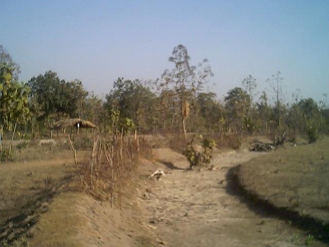
It is a structural measure. The bund is constructed taking the excavated earth from a trench of 1.5m X 0.3m cross section and leaving a berm of 0.3m and put along the contour. Loose boulder water way are constructed on the bund for safe disposal of excess run off.
Purpose: To break the slope of land. To reduce the velocity of runoff. To increase the in situ soil moisture and increase ground water table. To reduce down stream sand casting.
Establishment / maintenance activities and inputs: The process adopted for implementation of the intervention followed participatory planning through resource mapping, transect, well being ranking, problem identification, prioritisation and negotiation; thus benefit sharing, contribution and future maintenance of the stucture is ensured before establishment of the structure. The poor land and poor people get the opportunity first.
2.3 รูปภาพของเทคโนโลยี
อัลบั้มสื่อบันทึก
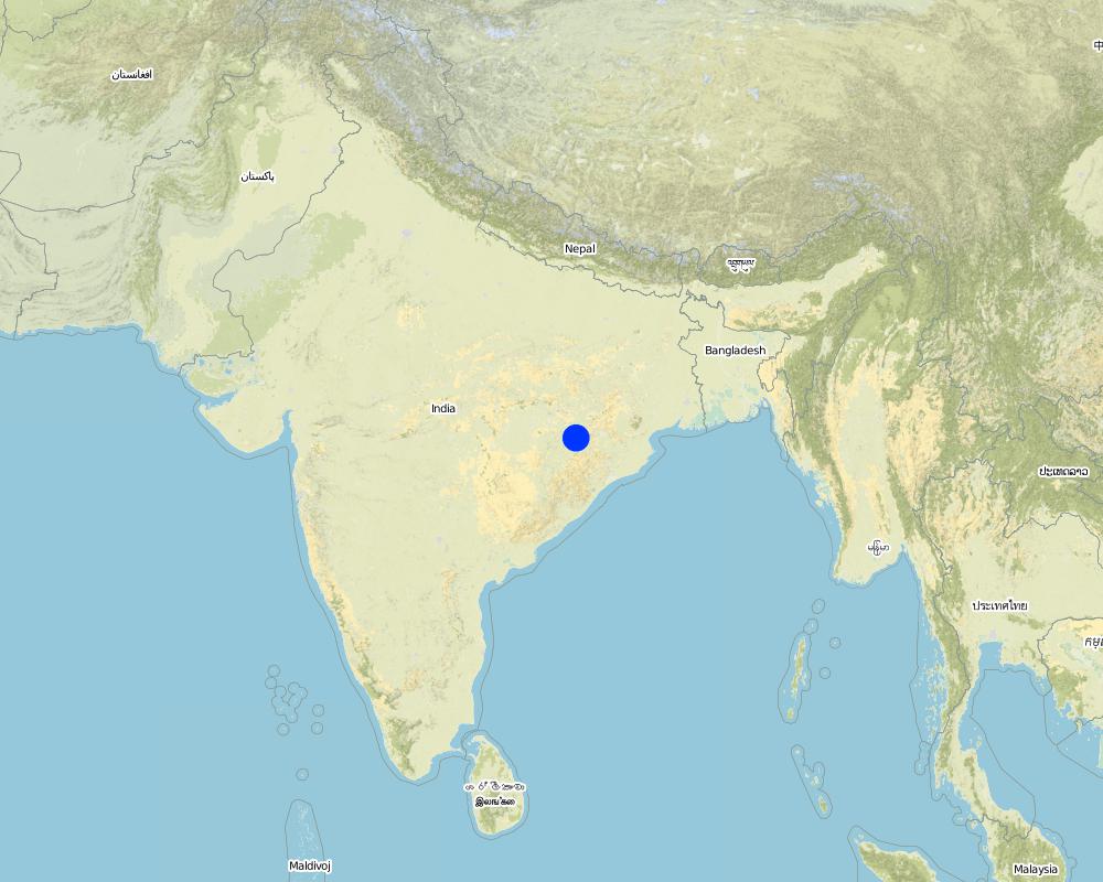
2.5 ประเทศภูมิภาค หรือสถานที่ตั้งที่เทคโนโลยีได้นำไปใช้และได้รับการครอบคลุมโดยการประเมินนี้
ประเทศ:
อินเดีย
ภูมิภาค/รัฐ/จังหวัด:
Orissa
ข้อมูลจำเพาะเพิ่มเติมของสถานที่ตั้ง :
Nangalbod-Tankamal Watershed,Mahanadi Basin
ระบุการกระจายตัวของเทคโนโลยี:
- กระจายไปอย่างสม่ำเสมอในพื้นที่
If the Technology is evenly spread over an area, specify area covered (in km2):
0.32
If precise area is not known, indicate approximate area covered:
- 0.1-1 ตร.กม.
แสดงความคิดเห็น:
Total area covered by the SLM Technology is 0.32 km2.
The technology area comprises of 0.3 2km2 within the watershed of 6 km2. The technology is an improvement of the age old practice of field bunding by the farmers.This has been promoted by the Soil Conservation department and watershed mission through watershed development programme.
Map
×2.6 วันที่การดำเนินการ
ถ้าไม่รู้ปีที่แน่นอน ให้ระบุวันที่โดยประมาณ:
- มากกว่า 50 ปี (แบบดั้งเดิม)
2.7 คำแนะนำของเทคโนโลยี
ให้ระบุว่าเทคโนโลยีถูกแนะนำเข้ามาอย่างไร:
- ทางโครงการหรือจากภายนอก
ความคิดเห็น (ประเภทของโครงการ เป็นต้น) :
Indegeneous but improved by Soil Conservation department, Watershed Mission, UNDP.
3. การจัดประเภทของเทคโนโลยี SLM
3.1 วัตถุประสงค์หลักของเทคโนโลยี
- ลด ป้องกัน ฟื้นฟู การเสื่อมโทรมของที่ดิน
3.2 ประเภทของการใช้ที่ดินในปัจจุบันที่ได้นำเทคโนโลยีไปใช้
Land use mixed within the same land unit:
ใช่
Specify mixed land use (crops/ grazing/ trees):
- การปลูกพืชร่วมกับปศุสัตว์และการทำป่าไม้ (Agro-silvopastoralism)

พื้นที่ปลูกพืช
- การปลูกพืชล้มลุกอายุปีเดียว
Annual cropping - Specify crops:
- cereals - millet
- rice
จำนวนของฤดูเพาะปลูกต่อปี:
- 1
ระบุ:
Longest growing period in days: 150 Longest growing period from month to month: Jun - Oct

ทุ่งหญ้าเลี้ยงสัตว์
Extensive grazing:
- การเลี้ยงสัตว์แบบเร่ร่อนไปตามที่ต่าง ๆ (Nomadism)
- cattle

ป่า/พื้นที่ทำไม้
- ป่ากึ่งธรรมชาติ / พื้นที่ทำไม้
(Semi-)natural forests/ woodlands: Specify management type:
- การตัดไม้ที่มีคัดเลือก (Selective felling)
ผลิตภัณฑ์และบริการ:
- ไม้ที่นำมาทำเป็นเชื้อเพลิง
- ผลไม้และถั่ว
- การแทะเล็มหญ้า / การเก็บกินหญ้า
แสดงความคิดเห็น:
Major land use problems (compiler’s opinion): The fertile top soil is gradually washed away.Productivity of the soil is also reduced. Thus, farmer is only taking minor millet in kharif.
Major land use problems (land users’ perception): Loss of production. Soil is unable to retain moisture, so we suffer crop loss during long dry spell.Due to sand casting crop is also partially damaged in the down stream.
Nomadism: People allow the cattle to graze freely in the field after the crop is harvested
Selective felling of (semi-) natural forests: Yes
Problems / comments regarding forest use: People have started managing forest through VSS and Forest protection committee.
Type of cropping system and major crops comments: minor millets and up land paddy are the major crop under rain fed condition
3.4 การใช้น้ำ
การใช้น้ำของที่ดินที่มีการใช้เทคโนโลยีอยู่:
- จากน้ำฝน
3.5 กลุ่ม SLM ที่ตรงกับเทคโนโลยีนี้
- มาตรการปลูกพืชขวางความลาดชัน (cross-slope measure)
- การผันน้ำและการระบายน้ำ
- การจัดการน้ำผิวดิน (น้ำพุ แม่น้ำทะเลสาบ ทะเล)
3.6 มาตรการ SLM ที่ประกอบกันเป็นเทคโนโลยี
3.7 รูปแบบหลักของการเสื่อมโทรมของที่ดินที่ได้รับการแก้ไขโดยเทคโนโลยี

การกัดกร่อนของดินโดยน้ำ
- Wt (Loss of topsoil): การสูญเสียดินชั้นบนหรือการกัดกร่อนที่ผิวดิน
- Wg (Gully erosion): การกัดกร่อนแบบร่องธารหรือการทำให้เกิดร่องน้ำเซาะ
แสดงความคิดเห็น:
Main type of degradation addressed: Wt: loss of topsoil / surface erosion
Secondary types of degradation addressed: Wg: gully erosion / gullying
Main causes of degradation: deforestation / removal of natural vegetation (incl. forest fires), education, access to knowledge and support services (Absence of institutional arrangements to disseminate the knowledge from lab to land and involve the users in implementation)
Secondary causes of degradation: overgrazing (Subsistence economy, dependance on forests for fuelwood and fodder, livestock were low quality, free grazing type. And these were no regulatory mechanisms to share usufruct from forests with people.), poverty / wealth (Lack of capital at the grassroot to take the initiative by the farmers themselves)
3.8 การป้องกัน การลดลง หรือการฟื้นฟูความเสื่อมโทรมของที่ดิน
ระบุเป้าหมายของเทคโนโลยีกับความเสื่อมโทรมของที่ดิน:
- ลดความเสื่อมโทรมของดิน
4. ข้อมูลจำเพาะด้านเทคนิค กิจกรรมการนำไปปฏิบัติใช้ ปัจจัยนำเข้า และค่าใช้จ่าย
4.1 แบบแปลนทางเทคนิคของเทคโนโลยี
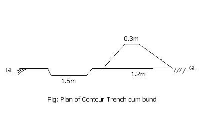
ข้อมูลจำเพาะด้านเทคนิค (แบบแปลนทางเทคนิคของเทคโนโลยี):
Technical knowledge required for field staff / advisors: moderate
Technical knowledge required for land users: low
Main technical functions: reduction of slope length
Secondary technical functions: control of dispersed runoff: retain / trap, control of concentrated runoff: impede / retard
Bund/ bank: semi-circular/V shaped trapezoidal
Vertical interval between structures (m): 1.5
Spacing between structures (m): 50
Height of bunds/banks/others (m): 0.45
Width of bunds/banks/others (m): 1.2
Length of bunds/banks/others (m): 60
Construction material (earth): earth is dug from the trench in the up stream
Construction material (stone): picked up boulders available locally
Slope (which determines the spacing indicated above): 3%
4.2 ข้อมูลทั่วไปเกี่ยวกับการคำนวณปัจจัยนำเข้าและค่าใช้จ่าย
อื่นๆ หรือสกุลเงินประจำชาติ (ระบุ):
Indian Rupee
If relevant, indicate exchange rate from USD to local currency (e.g. 1 USD = 79.9 Brazilian Real): 1 USD =:
50.0
ระบุค่าเฉลี่ยของค่าจ้างในการจ้างแรงงานต่อวัน:
1.00
4.3 กิจกรรมเพื่อการจัดตั้ง
| กิจกรรม | Timing (season) | |
|---|---|---|
| 1. | Survey and alignment of trench, bund | dry season |
| 2. | Digging of trenches and construction of bunds | dry season |
| 3. | Construction of water way | dry season |
4.4 ค่าใช้จ่ายของปัจจัยนำเข้าที่จำเป็นสำหรับการจัดตั้ง
| ปัจจัยนำเข้า | หน่วย | ปริมาณ | ค่าใช้จ่ายต่อหน่วย | ค่าใช้จ่ายทั้งหมดต่อปัจจัยนำเข้า | %ของค่าใช้จ่ายที่ก่อให้เกิดขึ้นโดยผู้ใช้ที่ดิน | |
|---|---|---|---|---|---|---|
| แรงงาน | Labour | ha | 1.0 | 100.0 | 100.0 | 30.0 |
| วัสดุสำหรับก่อสร้าง | Stone | ha | 1.0 | 2.0 | 2.0 | |
| วัสดุสำหรับก่อสร้าง | Earth | ha | 1.0 | 98.0 | 98.0 | 30.0 |
| ค่าใช้จ่ายทั้งหมดของการจัดตั้งเทคโนโลยี | 200.0 | |||||
| Total costs for establishment of the Technology in USD | 4.0 | |||||
แสดงความคิดเห็น:
Duration of establishment phase: 12 month(s)
4.5 การบำรุงรักษาสภาพหรือกิจกรรมที่เกิดขึ้นเป็นประจำ
| กิจกรรม | ช่วงระยะเวลา/ความถี่ | |
|---|---|---|
| 1. | Grass turfing on bunds | during rainy season/annual |
| 2. | Maintaining shape and size of bund | after rainy season/annual |
| 3. | rearranging dispersed stone in water way | after rainy season/annual |
4.6 ค่าใช้จ่ายของปัจจัยนำเข้าและกิจกรรมที่เกิดขึ้นเป็นประจำที่ต้องการการบำรุงรักษา (ต่อปี)
แสดงความคิดเห็น:
Cross-section and length of the structure per hectare
4.7 ปัจจัยสำคัญที่สุดที่มีผลกระทบต่อค่าใช้จ่าย
ปัจจัยสำคัญที่สุดที่มีผลกระทบต่อค่าใช้จ่ายต่างๆ:
labour
5. สิ่งแวดล้อมทางธรรมชาติและของมนุษย์
5.1 ภูมิอากาศ
ฝนประจำปี
- < 250 ม.ม.
- 251-500 ม.ม.
- 501-750 ม.ม.
- 751-1,000 ม.ม.
- 1,001-1,500 ม.ม.
- 1,501-2,000 ม.ม.
- 2,001-3,000 ม.ม.
- 3,001-4,000 ม.ม.
- > 4,000 ม.ม.
ระบุปริมาณน้ำฝนเฉลี่ยรายปี (ถ้ารู้) :หน่วย ม.ม.
1382.00
เขตภูมิอากาศเกษตร
- กึ่งแห้งแล้ง
80-100 days of rainfall occurs in most part of the state
5.2 สภาพภูมิประเทศ
ค่าเฉลี่ยความลาดชัน:
- ราบเรียบ (0-2%)
- ลาดที่ไม่ชัน (3-5%)
- ปานกลาง (6-10%)
- เป็นลูกคลื่น (11-15%)
- เป็นเนิน (16-30%)
- ชัน (31-60%)
- ชันมาก (>60%)
ธรณีสัณฐาน:
- ที่ราบสูง/ที่ราบ
- สันเขา
- ไหล่เขา
- ไหล่เนินเขา
- ตีนเนิน
- หุบเขา
ระดับความสูง:
- 0-100 เมตร
- 101-500 เมตร
- 501-1,000 เมตร
- 1,001-1,500 เมตร
- 1,501-2,000 เมตร
- 2,001-2,500 เมตร
- 2,501-3,000 เมตร
- 3,001-4,000 เมตร
- > 4,000 เมตร
ความคิดเห็นและข้อมูลจำเพาะเพิ่มเติมเรื่องสภาพภูมิประเทศ:
Altitudinal zone: 101-500 m a.s.l. ( the technology area is located at 196m.a.s.l.)
Landforms: Hill slopes (ranked 1, the surrounding area is coverd with hillocks with forest) and footslopes (ranked 2, the technology area has undulating slopes with forest in betweem and mild slope)
Slopes on average: Also gentle (ranked 2) and flat (ranked 3)
5.3 ดิน
ค่าเฉลี่ยความลึกของดิน:
- ตื้นมาก (0-20 ซ.ม.)
- ตื้น (21-50 ซ.ม.)
- ลึกปานกลาง (51-80 ซ.ม.)
- ลึก (81-120 ซ.ม.)
- ลึกมาก (>120 ซ.ม.)
เนื้อดิน (ดินชั้นบน):
- หยาบ/เบา (ดินทราย)
อินทรียวัตถุในดิน:
- ต่ำ (<1%)
(ถ้ามี) ให้แนบคำอธิบายเรื่องดินแบบเต็มหรือระบุข้อมูลที่มีอยู่ เช่น ชนิดของดิน ค่า pH ของดินหรือความเป็นกรดของดิน ความสามารถในการแลกเปลี่ยนประจุบวก ไนโตรเจน ความเค็ม เป็นต้น:
Soil depth on average: Also moderately deep (ranked 2) and deep (ranked 3)
Soil texture: Also medium (ranked 2) and fine/havey (ranked 3)
Soil fertility: Very low (ranked 1), low (ranked 2) and medium (ranked 3)
Topsoil organic matter: Also medium (ranked 2) and high (ranked 3)
Soil drainage/infiltration: Good (ranked 1) and medium (ranked 2)
Soil water storage capacity: Very low (ranked 1), low (ranked 2) and medium (ranked 3)
5.6 ลักษณะของผู้ใช้ที่ดินที่นำเทคโนโลยีไปปฏิบัติใช้
แนวทางการตลาดของระบบการผลิต:
- เพื่อการยังชีพ (หาเลี้ยงตนเอง)
- mixed (subsistence/ commercial)
รายได้ที่มาจากนอกฟาร์ม:
- 10-50% ของรายได้ทั้งหมด
ระดับของความมั่งคั่งโดยเปรียบเทียบ:
- รวย
- รวยมาก
ระดับของการใช้เครื่องจักรกล:
- งานที่ใช้แรงกาย
- การใช้กำลังจากสัตว์
ระบุลักษณะอื่นๆที่เกี่ยวข้องของผู้ใช้ที่ดิน:
Population density: 100-200 persons/km2
Annual population growth: > 4%
30% of the land users are very rich and own 5% of the land.
20% of the land users are rich and own 15% of the land.
25% of the land users are average wealthy and own 20% of the land.
20% of the land users are poor and own 30% of the land.
5% of the land users are poor and own 25% of the land.
Off-farm income specification: The livelihoods is less diversified. They also depends on NTFP marketing, off farm activities.
Level of mechanization: Animal traction (ranked ) and manual work (ranked 2)
5.7 Average area of land used by land users applying the Technology
- < 0.5 เฮกตาร์
- 0.5-1 เฮกตาร์
- 1-2 เฮกตาร์
- 2-5 เฮกตาร์
- 5-15 เฮกตาร์
- 15-50 เฮกตาร์
- 50-100 เฮกตาร์
- 100-500 เฮกตาร์
- 500-1,000 เฮกตาร์
- 1,000-10,000 เฮกตาร์
- >10,000 เฮกตาร์
แสดงความคิดเห็น:
Average area of land owned or leased by land users applying the Technology:
Cropland: 0.5-1ha (ranked 1, marginal farmers)
1-2 ha (ranked 2, small farmers)
2-5 ha (ranked 3, big farmers)
5.8 กรรมสิทธิ์ในที่ดิน สิทธิในการใช้ที่ดินและสิทธิในการใช้น้ำ
กรรมสิทธิ์ในที่ดิน:
- เป็นแบบชุมชนหรือหมู่บ้าน
- รายบุคคล ได้รับสิทธิครอบครอง
สิทธิในการใช้ที่ดิน:
- เกี่ยวกับชุมชน (ถูกจัดระเบียบ)
- รายบุคคล
6. ผลกระทบและสรุปคำบอกกล่าว
6.1 ผลกระทบในพื้นที่ดำเนินการ (On-site) จากการใช้เทคโนโลยี
ผลกระทบทางด้านเศรษฐกิจและสังคม
การผลิต
การผลิตพืชผล
การผลิตพืชที่ใช้เลี้ยงปศุสัตว์
คุณภาพพืชที่ใช้เลี้ยงปศุสัตว์
การผลิตสัตว์
พื้นที่สำหรับการผลิต
แสดงความคิดเห็น/ระบุ:
Due to construction of bund
รายได้และค่าใช้จ่าย
รายได้จากฟาร์ม
ผลกระทบทางด้านเศรษฐกิจและสังคมอื่น ๆ
Formal credit
Input constraints
แสดงความคิดเห็น/ระบุ:
Timely availability of inputs
ผลกระทบด้านสังคมวัฒนธรรมอื่น ๆ
สถาบันของชุมชน
แสดงความคิดเห็น/ระบุ:
22 SHGs has been formed and strengthened
SLM หรือความรู้เรื่องความเสื่อมโทรมของที่ดิน
แสดงความคิดเห็น/ระบุ:
NRM volunteers has been developed
การบรรเทาความขัดแย้ง
แสดงความคิดเห็น/ระบุ:
During identification of land ownership and location of waterways
ผลกระทบด้านนิเวศวิทยา
ดิน
ความชื้นในดิน
สิ่งปกคลุมดิน
ผลกระทบด้านนิเวศวิทยาอื่น ๆ
Soil fertility
6.2 ผลกระทบนอกพื้นที่ดำเนินการ (Off-site) จากการใช้เทคโนโลยี
น้ำท่วมพื้นที่ท้ายน้ำ
การทับถมของดินตะกอนพื้นที่ท้ายน้ำ
Water table in wells
Water availability in WHS
6.4 การวิเคราะห์ค่าใช้จ่ายและผลประโยชน์ที่ได้รับ
ผลประโยชน์ที่ได้รับเปรียบเทียบกับค่าใช้จ่ายในการจัดตั้งเป็นอย่างไร (จากมุมมองของผู้ใช้ที่ดิน)
ผลตอบแทนระยะสั้น:
ด้านบวก
ผลตอบแทนระยะยาว:
ด้านบวก
ผลประโยชน์ที่ได้รับเปรียบเทียบกับค่าใช้จ่ายในการบำรุงรักษาหรือต้นทุนที่เกิดขึ้นซ้ำอีก เป็นอย่างไร (จากมุมมองของผู้ใช้ที่ดิน)
ผลตอบแทนระยะสั้น:
ด้านบวก
ผลตอบแทนระยะยาว:
ด้านบวก
6.5 การปรับตัวของเทคโนโลยี
ถ้ามีข้อมูลให้บอกปริมาณด้วย (จำนวนของครัวเรือนหรือครอบคลุมพื้นที่):
24
แสดงความคิดเห็น:
100% of land user families have adopted the Technology with external material support
12 land user families have adopted the Technology with external material support
Comments on acceptance with external material support: survey results
12 land user families have adopted the Technology without any external material support
Comments on spontaneous adoption: survey results
There is a moderate trend towards spontaneous adoption of the Technology
Comments on adoption trend: The farmers have realised the benefits from farmers' group meeting and visiting to the technology area.The farmers have started maintaining the bunds. They have also started taking crops both on bunds and field.
6.7 จุดแข็ง / ข้อได้เปรียบ / โอกาสของเทคโนโลยี
| จุดแข็ง / ข้อได้เปรียบ / โอกาสในทัศนคติของผู้ใช้ที่ดิน |
|---|
|
Our crop can with stand dry spell How can they be sustained / enhanced? Planting of glaricidia and use of compost |
|
Value of land will increase How can they be sustained / enhanced? By maintaining bunds |
|
We can take crop in bunds How can they be sustained / enhanced? planting of bengal grams, tils, cow pea and sima |
| จุดแข็ง / ข้อได้เปรียบ / โอกาสในทัศนคติของผู้รวบรวมหรือวิทยากรหลัก |
|---|
|
Reduce runoff and velocity How can they be sustained / enhanced? Desilting from the trenches |
|
Reduce sand casting in the down stream How can they be sustained / enhanced? Desilting from the trenches |
|
Crop diversification and promotion of improved agricultural practices How can they be sustained / enhanced? Through capacity building of volunteers and land users |
6.8 จุดอ่อน / ข้อเสียเปรียบ / ความเสี่ยงของเทคโนโลยีและวิธีการแก้ไข
| จุดอ่อน / ข้อเสียเปรียบ / ความเสี่ยงในทัศนคติของผู้ใช้ที่ดิน | มีวิธีการแก้ไขได้อย่างไร |
|---|---|
| loss of land | Productive use of trench and bunds |
| จุดอ่อน / ข้อเสียเปรียบ / ความเสี่ยงในทัศนคติของผู้รวบรวมหรือวิทยากรหลัก | มีวิธีการแก้ไขได้อย่างไร |
|---|---|
| Regular maintenance of the stone surplus | promote and strengthen user group |
| Open grazing | Promote community farming for collective actions |
7. การอ้างอิงและการเชื่อมต่อ
7.1 วิธีการและแหล่งข้อมูล
7.2 การอ้างอิงถึงสิ่งตีพิมพ์
หัวข้อ, ผู้เขียน, ปี, หมายเลข ISBN:
Micro plan of Nangalbod-tankamal watershed. 12/30/2004.
ชื่อเรื่อง ผู้เขียน ปี ISBN:
Project Direcotr watershed, Nuapada
หัวข้อ, ผู้เขียน, ปี, หมายเลข ISBN:
district Statistical hand book. 12/30/2004.
ชื่อเรื่อง ผู้เขียน ปี ISBN:
Project Direcotr watershed, Nuapada
ลิงก์และโมดูล
ขยายทั้งหมด ย่อทั้งหมดลิงก์
Participatory Sustainable Rural Livelihood Approach [อินเดีย]
Participatory Sustainable Rural Livelihood Approach adopts participatory tools for livelihood situational analysis of the five capitals(Physical, Financila,Social, Human and Natural) and prepare livelihood focussed micro plan with the commuity for sustai
- ผู้รวบรวม: Niranjan Sahu
โมดูล
ไม่มีโมดูล