Check dam ponds [เอธิโอเปีย]
- ผู้สร้างสรรค์:
- การอัพเดท:
- ผู้รวบรวม: Eyasu Yazew
- ผู้เรียบเรียง: –
- ผู้ตรวจสอบ: Fabian Ottiger, Alexandra Gavilano
May me'ekori ketri
technologies_1547 - เอธิโอเปีย
ดูส่วนย่อย
ขยายทั้งหมด ย่อทั้งหมด1. ข้อมูลทั่วไป
1.2 รายละเอียดที่ติดต่อได้ของผู้รวบรวมและองค์กรที่เกี่ยวข้องในการประเมินและการจัดเตรียมทำเอกสารของเทคโนโลยี
ผู้เชี่ยวชาญ SLM:
ผู้เชี่ยวชาญ SLM:
Kifle Weldearegay
Mekelle University
เอธิโอเปีย
ชื่อขององค์กรซึ่งอำนวยความสะดวกในการทำเอกสารหรือการประเมินเทคโนโลยี (ถ้าเกี่ยวข้อง)
Mekelle University (Mekelle University) - เอธิโอเปีย1.3 เงื่อนไขการใช้ข้อมูลที่ได้บันทึกผ่านทาง WOCAT
ผู้รวบรวมและวิทยากรหลักยอมรับเงื่อนไขเกี่ยวกับการใช้ข้อมูลที่ถูกบันทึกผ่านทาง WOCAT:
ใช่
2. การอธิบายลักษณะของเทคโนโลยี SLM
2.1 การอธิบายแบบสั้น ๆ ของเทคโนโลยี
คำจำกัดความของเทคโนโลยี:
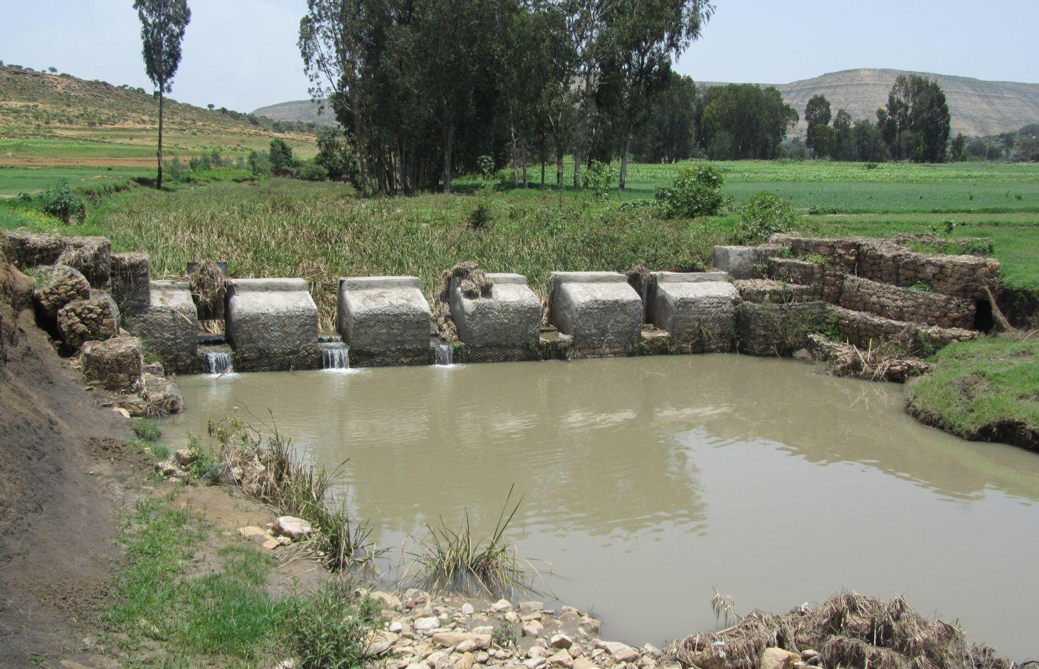
It is a raised wall constructed across a stream/gully using stone, concrete and/or gabion for dual purpose, namely, to pond/store the stream flow behind it for irrigation purpose while at the same time reducing the runoff velocity and enhancing gully rehabilitation.
2.2 การอธิบายแบบละเอียดของเทคโนโลยี
คำอธิบาย:
A check dam pond is a raised wall constructed across a gully from stone, concrete and/or gabion to store water behind it for irrigation purpose using either gravity or lifting mechanism. The structure generally consists of construction of foundation, apron, retaining wall and the checkdam. The width of the checkdam ranges between 1 - 2 m while the height varies between 1 - 2 m depending up on the gully depth. The length of the checkdam depends on the gully width. The spacing between adjacent checkdams is determined based on two factors, namely, the gradient of the river bed and the availability of potential land that can be irrigated. It is also provided with a number of sluice gates which will be removed during the main rainy season to minimize siltation.
Purpose of the Technology: In addition to storing water for irrigation, check dam ponds decrease slope length, slope angle, runoff velocity and minimize soil erosion.
Establishment / maintenance activities and inputs: Establishment of a check dam pond starts with collection and transportation of stone and sand. The construction is started by setting out the dimensions from the design on the selected site and excavating the foundation for the different parts, namely, key trench, apron and retaining wall. The check dam is then constructed using gabions filled with stones and tightly tied together with wire. Finally the superstructure is plastered using mortar to prevent the passage of water through the body. Gates of about 1 m wide are finally constructed at about 1 m interval and fitted with sluice gates. Maintenance usually involves fixing damaged gates and reinforcing gabions.
Natural / human environment: Check dam pond is implemented in gentle (2 - 5%) and moderate (5 - 8%) slopes and in medium and light soil types of at least 1 m depth. It increases water availability for irrigation and livestock consumption purposes. It also reduces runoff velocity thereby decreasing soil erosion and enhancing gully rehabilitation.
It requires skilled labour and high construction cost. As a result, it is constructed through external support. However, the number of communities seeking for external support and willing to contribute their share is at the rise. The technology minimizes greatly the risk of crop failure and improves the livelihood of the land users.
2.3 รูปภาพของเทคโนโลยี
อัลบั้มสื่อบันทึก

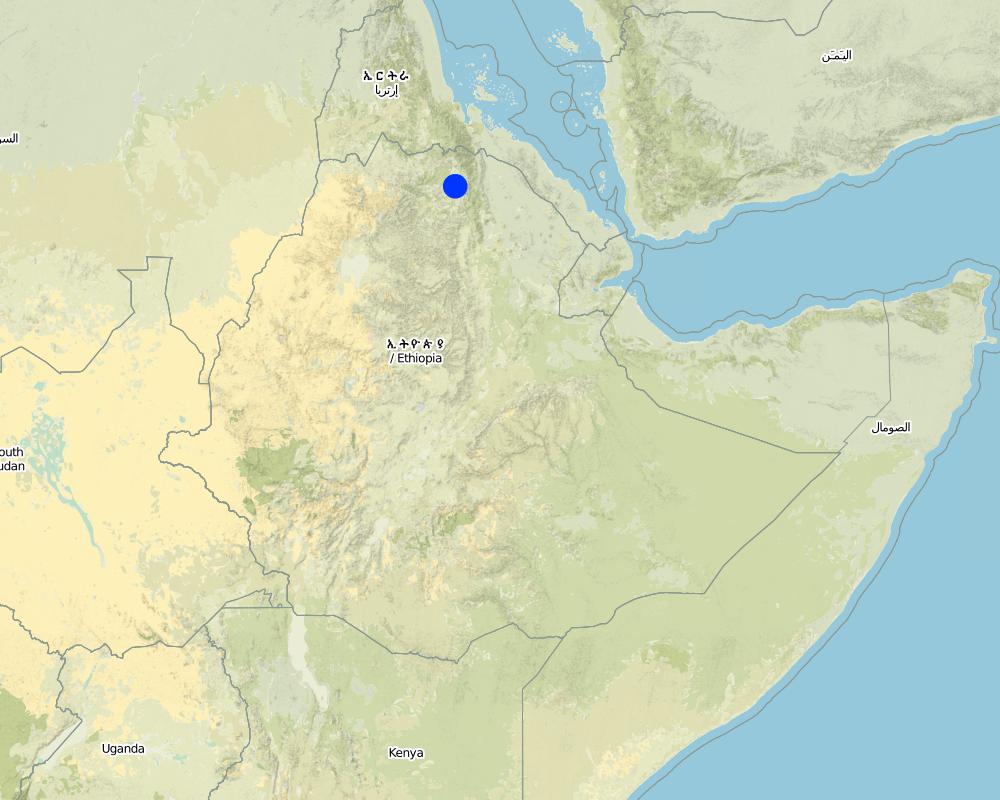
2.5 ประเทศภูมิภาค หรือสถานที่ตั้งที่เทคโนโลยีได้นำไปใช้และได้รับการครอบคลุมโดยการประเมินนี้
ประเทศ:
เอธิโอเปีย
ภูมิภาค/รัฐ/จังหวัด:
Tigray
ข้อมูลจำเพาะเพิ่มเติมของสถานที่ตั้ง :
Kilite Awlaelo
ระบุการกระจายตัวของเทคโนโลยี:
- กระจายไปอย่างสม่ำเสมอในพื้นที่
If precise area is not known, indicate approximate area covered:
- 1-10 ตร.กม.
Map
×2.6 วันที่การดำเนินการ
ถ้าไม่รู้ปีที่แน่นอน ให้ระบุวันที่โดยประมาณ:
- น้อยกว่า 10 ปี (ไม่นานนี้)
2.7 คำแนะนำของเทคโนโลยี
ให้ระบุว่าเทคโนโลยีถูกแนะนำเข้ามาอย่างไร:
- ทางโครงการหรือจากภายนอก
3. การจัดประเภทของเทคโนโลยี SLM
3.2 ประเภทของการใช้ที่ดินในปัจจุบันที่ได้นำเทคโนโลยีไปใช้

พื้นที่ปลูกพืช
- การปลูกพืชล้มลุกอายุปีเดียว
Annual cropping - Specify crops:
- cereals - barley
- cereals - maize
- vegetables - root vegetables (carrots, onions, beet, other)
- tomatoes, wheat, teff
จำนวนของฤดูเพาะปลูกต่อปี:
- 2
ระบุ:
Longest growing period in days: 150Longest growing period from month to month: June - NovemberSecond longest growing period in days: 105Second longest growing period from month to month: January - April
แสดงความคิดเห็น:
Major land use problems (compiler’s opinion): Deforestation and overgrazing, high erosion risk, gully formation and land loss, decline in productivity.
Major land use problems (land users’ perception): Population pressure, deforestation, flood, soil erosion, reduced productivity.
3.4 การใช้น้ำ
การใช้น้ำของที่ดินที่มีการใช้เทคโนโลยีอยู่:
- น้ำฝนร่วมกับการชลประทาน
3.5 กลุ่ม SLM ที่ตรงกับเทคโนโลยีนี้
- การเก็บเกี่ยวน้ำ
- การจัดการด้านชลประทาน (รวมถึงการลำเลียงส่งน้ำ การระบายน้ำ)
- การจัดการน้ำผิวดิน (น้ำพุ แม่น้ำทะเลสาบ ทะเล)
3.6 มาตรการ SLM ที่ประกอบกันเป็นเทคโนโลยี

มาตรการอนุรักษ์ด้วยโครงสร้าง
- S6: กำแพง สิ่งกีดขวาง รั้วไม้ รั้วต่างๆ
แสดงความคิดเห็น:
Main measures: structural measures
3.7 รูปแบบหลักของการเสื่อมโทรมของที่ดินที่ได้รับการแก้ไขโดยเทคโนโลยี

การกัดกร่อนของดินโดยน้ำ
- Wt (Loss of topsoil): การสูญเสียดินชั้นบนหรือการกัดกร่อนที่ผิวดิน
- Wg (Gully erosion): การกัดกร่อนแบบร่องธารหรือการทำให้เกิดร่องน้ำเซาะ
- Wm (Mass movement): การเคลื่อนตัวของมวลดินหรือดินถล่ม
- Wo (Offsite degradation): ผลกระทบนอกพื้นที่
แสดงความคิดเห็น:
Main type of degradation addressed: Wg: gully erosion / gullying
Secondary types of degradation addressed: Wt: loss of topsoil / surface erosion, Wm: mass movements / landslides, Wo: offsite degradation effects
Main causes of degradation: deforestation / removal of natural vegetation (incl. forest fires), Heavy / extreme rainfall (intensity/amounts), other natural causes (avalanches, volcanic eruptions, mud flows, highly susceptible natural resources, extreme topography, etc.) specify (Steep topography that increases amount and velocity of flood), population pressure
Secondary causes of degradation: crop management (annual, perennial, tree/shrub), over-exploitation of vegetation for domestic use, overgrazing, floods, land tenure, poverty / wealth, education, access to knowledge and support services
3.8 การป้องกัน การลดลง หรือการฟื้นฟูความเสื่อมโทรมของที่ดิน
ระบุเป้าหมายของเทคโนโลยีกับความเสื่อมโทรมของที่ดิน:
- ลดความเสื่อมโทรมของดิน
- ฟื้นฟูบำบัดที่ดินที่เสื่อมโทรมลงอย่างมาก
แสดงความคิดเห็น:
Main goals: mitigation / reduction of land degradation
Secondary goals: rehabilitation / reclamation of denuded land
4. ข้อมูลจำเพาะด้านเทคนิค กิจกรรมการนำไปปฏิบัติใช้ ปัจจัยนำเข้า และค่าใช้จ่าย
4.1 แบบแปลนทางเทคนิคของเทคโนโลยี
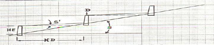
ข้อมูลจำเพาะด้านเทคนิค (แบบแปลนทางเทคนิคของเทคโนโลยี):
Check dam ponds are raised walls constructed across a stream/gully using stone, concrete and/or gabion for dual purpose, namely, to pond/store the stream flow behind it for irrigation purpose while at the same time reducing the runoff velocity and enhancing gully rehabilitation.
Location: Tigray. Kilte Awlaelo
Date: 10/10/2014
Technical knowledge required for field staff / advisors: high
Technical knowledge required for land users: high
Technical knowledge required for Engineer/designer: high
Main technical functions: control of dispersed runoff: impede / retard, reduction of slope length
Secondary technical functions: reduction of slope angle, increase of infiltration, increase of groundwater level / recharge of groundwater, sediment retention / trapping, sediment harvesting
Wall/ barrier
Vertical interval between structures (m): n/a
Spacing between structures (m): n/a
Height of bunds/banks/others (m): 1 - 2
Width of bunds/banks/others (m): 1 - 2
Construction material (stone): Stones are usually shaped in order to piece together very well.
Construction material (concrete): The chekdam is usually plastered by concrete on the upstream side to prevent the passage of water th
Construction material (other): Gabion, Sheet metal and Angle iron.
Slope (which determines the spacing indicated above): 2 - 8%
Lateral gradient along the structure: 0%
ผู้เขียน:
Eyasu Yazew, P.O.Box 231, Mekelle University, Mekelle, Ethiopia
4.2 ข้อมูลทั่วไปเกี่ยวกับการคำนวณปัจจัยนำเข้าและค่าใช้จ่าย
อื่นๆ หรือสกุลเงินประจำชาติ (ระบุ):
Birr
If relevant, indicate exchange rate from USD to local currency (e.g. 1 USD = 79.9 Brazilian Real): 1 USD =:
18.0
ระบุค่าเฉลี่ยของค่าจ้างในการจ้างแรงงานต่อวัน:
2.50
4.3 กิจกรรมเพื่อการจัดตั้ง
| กิจกรรม | Timing (season) | |
|---|---|---|
| 1. | Site clearance and excavation of foundation | Dry season |
| 2. | Stone collection and transportation | Dry season |
| 3. | Sand collection and transportation | Dry season |
| 4. | Gabion masonry work | Dry season |
| 5. | Plastering | Dry season |
4.4 ค่าใช้จ่ายของปัจจัยนำเข้าที่จำเป็นสำหรับการจัดตั้ง
| ปัจจัยนำเข้า | หน่วย | ปริมาณ | ค่าใช้จ่ายต่อหน่วย | ค่าใช้จ่ายทั้งหมดต่อปัจจัยนำเข้า | %ของค่าใช้จ่ายที่ก่อให้เกิดขึ้นโดยผู้ใช้ที่ดิน | |
|---|---|---|---|---|---|---|
| แรงงาน | Labour | ha | 1.0 | 4678.0 | 4678.0 | 25.0 |
| วัสดุสำหรับก่อสร้าง | Cement | ha | 1.0 | 953.0 | 953.0 | |
| วัสดุสำหรับก่อสร้าง | Gabion | ha | 1.0 | 6268.0 | 6268.0 | |
| วัสดุสำหรับก่อสร้าง | Sheet metal | ha | 1.0 | 44.0 | 44.0 | |
| วัสดุสำหรับก่อสร้าง | Angle iron | ha | 1.0 | 56.0 | 56.0 | |
| ค่าใช้จ่ายทั้งหมดของการจัดตั้งเทคโนโลยี | 11999.0 | |||||
| Total costs for establishment of the Technology in USD | 666.61 | |||||
แสดงความคิดเห็น:
Duration of establishment phase: 6 month(s)
4.5 การบำรุงรักษาสภาพหรือกิจกรรมที่เกิดขึ้นเป็นประจำ
| กิจกรรม | ช่วงระยะเวลา/ความถี่ | |
|---|---|---|
| 1. | Fixing damaged gates and reinforcing gabions | Dry season |
4.6 ค่าใช้จ่ายของปัจจัยนำเข้าและกิจกรรมที่เกิดขึ้นเป็นประจำที่ต้องการการบำรุงรักษา (ต่อปี)
แสดงความคิดเห็น:
Machinery/ tools: Digging hoe, shovel, hammer, crow bar
Since the check dam ponds generally vary in depth, width and most importantly in length depending up on the gully profile, calculation of cost per meter length will not be a reliable presentation. As a result, one typical check dam pond was selected and the total volume of the structure and the corresponding total cost of construction calculated. Then, the cost per cubic meter of the check dam was determined by dividing the total construction cost to the total volume of the structure.
The calculation includes the cost for the purchase of industrial materials (cement, gabion, sheet metal and angle iron) and cost of labour used for the construction including site clearance and excavation of foundation, stone and sand collection and transportation, gabion masonry work and plastering.
The price of the industrial materials and the labour wage used in the cost calculation apply to 2012. The daily labour wage for plastering is 180 Birr while it is 50 Birr for all other works.
4.7 ปัจจัยสำคัญที่สุดที่มีผลกระทบต่อค่าใช้จ่าย
ปัจจัยสำคัญที่สุดที่มีผลกระทบต่อค่าใช้จ่ายต่างๆ:
Labour, availability of construction material, depth and width of gully.
5. สิ่งแวดล้อมทางธรรมชาติและของมนุษย์
5.1 ภูมิอากาศ
ฝนประจำปี
- < 250 ม.ม.
- 251-500 ม.ม.
- 501-750 ม.ม.
- 751-1,000 ม.ม.
- 1,001-1,500 ม.ม.
- 1,501-2,000 ม.ม.
- 2,001-3,000 ม.ม.
- 3,001-4,000 ม.ม.
- > 4,000 ม.ม.
ข้อมูลจำเพาะ/ความคิดเห็นเรื่องปริมาณน้ำฝน:
Average rainfall of 450-550 mm, Main rainy season from Mid-June to August.
เขตภูมิอากาศเกษตร
- กึ่งแห้งแล้ง
Thermal climate class: subtropics
5.2 สภาพภูมิประเทศ
ค่าเฉลี่ยความลาดชัน:
- ราบเรียบ (0-2%)
- ลาดที่ไม่ชัน (3-5%)
- ปานกลาง (6-10%)
- เป็นลูกคลื่น (11-15%)
- เป็นเนิน (16-30%)
- ชัน (31-60%)
- ชันมาก (>60%)
ธรณีสัณฐาน:
- ที่ราบสูง/ที่ราบ
- สันเขา
- ไหล่เขา
- ไหล่เนินเขา
- ตีนเนิน
- หุบเขา
ระดับความสูง:
- 0-100 เมตร
- 101-500 เมตร
- 501-1,000 เมตร
- 1,001-1,500 เมตร
- 1,501-2,000 เมตร
- 2,001-2,500 เมตร
- 2,501-3,000 เมตร
- 3,001-4,000 เมตร
- > 4,000 เมตร
5.3 ดิน
ค่าเฉลี่ยความลึกของดิน:
- ตื้นมาก (0-20 ซ.ม.)
- ตื้น (21-50 ซ.ม.)
- ลึกปานกลาง (51-80 ซ.ม.)
- ลึก (81-120 ซ.ม.)
- ลึกมาก (>120 ซ.ม.)
เนื้อดิน (ดินชั้นบน):
- หยาบ/เบา (ดินทราย)
- ปานกลาง (ดินร่วน ทรายแป้ง)
อินทรียวัตถุในดิน:
- ต่ำ (<1%)
(ถ้ามี) ให้แนบคำอธิบายเรื่องดินแบบเต็มหรือระบุข้อมูลที่มีอยู่ เช่น ชนิดของดิน ค่า pH ของดินหรือความเป็นกรดของดิน ความสามารถในการแลกเปลี่ยนประจุบวก ไนโตรเจน ความเค็ม เป็นต้น:
Soil fertility is low (medium soils, ranked 1) and very low (light soils, ranked 2)
Soil drainage/infiltration is medium (ranked 1) and good (ranked 2)
Soil water storage capacity is medium (ranked 1) and low (ranked 2)
5.4 ความเป็นประโยชน์และคุณภาพของน้ำ
ระดับน้ำใต้ดิน:
5-50 เมตร
น้ำไหลบ่าที่ผิวดิน:
ดี
คุณภาพน้ำ (ที่ยังไม่ได้บำบัด):
เป็นน้ำใช้เพื่อการเกษตรเท่านั้น (การชลประทาน)
ความคิดเห็นและข้อมูลจำเพาะเพิ่มเติมเรื่องคุณภาพและปริมาณน้ำ:
Availability of surface water is good (September - January). Also medium (February-June)
5.5 ความหลากหลายทางชีวภาพ
ความหลากหลายทางชนิดพันธุ์:
- ต่ำ
5.6 ลักษณะของผู้ใช้ที่ดินที่นำเทคโนโลยีไปปฏิบัติใช้
แนวทางการตลาดของระบบการผลิต:
- เพื่อการยังชีพ (หาเลี้ยงตนเอง)
รายได้ที่มาจากนอกฟาร์ม:
- < 10% ของรายได้ทั้งหมด
ระดับของความมั่งคั่งโดยเปรียบเทียบ:
- จน
- พอมีพอกิน
เป็นรายบุคคล/ครัวเรือน:
- กลุ่ม/ชุมชน
ระดับของการใช้เครื่องจักรกล:
- งานที่ใช้แรงกาย
- การใช้กำลังจากสัตว์
เพศ:
- หญิง
- ชาย
ระบุลักษณะอื่นๆที่เกี่ยวข้องของผู้ใช้ที่ดิน:
Land users applying the Technology are mainly common / average land users
Population density: 100-200 persons/km2
Annual population growth: 2% - 3%
10% of the land users are rich and own 10% of the land.
60% of the land users are average wealthy and own 55% of the land (35 Birr/day/person).
30% of the land users are poor and own 35% of the land.
5.7 Average area of land used by land users applying the Technology
- < 0.5 เฮกตาร์
- 0.5-1 เฮกตาร์
- 1-2 เฮกตาร์
- 2-5 เฮกตาร์
- 5-15 เฮกตาร์
- 15-50 เฮกตาร์
- 50-100 เฮกตาร์
- 100-500 เฮกตาร์
- 500-1,000 เฮกตาร์
- 1,000-10,000 เฮกตาร์
- >10,000 เฮกตาร์
พิจารณาว่าเป็นขนาดเล็ก กลาง หรือขนาดใหญ่ (ซึ่งอ้างอิงถึงบริบทระดับท้องถิ่น):
- ขนาดเล็ก
แสดงความคิดเห็น:
Average land holding is 0.6 ha per household.
5.8 กรรมสิทธิ์ในที่ดิน สิทธิในการใช้ที่ดินและสิทธิในการใช้น้ำ
กรรมสิทธิ์ในที่ดิน:
- รัฐ
สิทธิในการใช้ที่ดิน:
- เกี่ยวกับชุมชน (ถูกจัดระเบียบ)
- รายบุคคล
สิทธิในการใช้น้ำ:
- เกี่ยวกับชุมชน (ถูกจัดระเบียบ)
5.9 การเข้าถึงบริการและโครงสร้างพื้นฐาน
สุขภาพ:
- จน
- ปานกลาง
- ดี
การศึกษา:
- จน
- ปานกลาง
- ดี
ความช่วยเหลือทางด้านเทคนิค:
- จน
- ปานกลาง
- ดี
การจ้างงาน (เช่น ภายนอกฟาร์ม):
- จน
- ปานกลาง
- ดี
ตลาด:
- จน
- ปานกลาง
- ดี
พลังงาน:
- จน
- ปานกลาง
- ดี
ถนนและการขนส่ง:
- จน
- ปานกลาง
- ดี
น้ำดื่มและการสุขาภิบาล:
- จน
- ปานกลาง
- ดี
บริการด้านการเงิน:
- จน
- ปานกลาง
- ดี
Mobile communication:
- จน
- ปานกลาง
- ดี
6. ผลกระทบและสรุปคำบอกกล่าว
6.1 ผลกระทบในพื้นที่ดำเนินการ (On-site) จากการใช้เทคโนโลยี
ผลกระทบทางด้านเศรษฐกิจและสังคม
การผลิต
การผลิตพืชผล
การเสี่ยงต่อความล้มเหลวในการผลิต
ความเป็นประโยชน์และคุณภาพของน้ำ
การมีน้ำไว้ให้ปศุสัตว์
คุณภาพน้ำสำหรับปศุสัตว์
การมีน้ำไว้ให้สำหรับการชลประทาน
คุณภาพน้ำสำหรับการชลประทาน
รายได้และค่าใช้จ่าย
ค่าใช่จ่ายของปัจจัยการผลิตทางการเกษตร
รายได้จากฟาร์ม
ภาระงาน
แสดงความคิดเห็น/ระบุ:
Also: Requires skilled labour
ผลกระทบด้านสังคมวัฒนธรรมอื่น ๆ
ความมั่นคงด้านอาหาร / พึ่งตนเองได้
สถานการณ์ด้านสุขภาพ
แสดงความคิดเห็น/ระบุ:
Increased investment in health care as a result of increased income.
สถาบันของชุมชน
SLM หรือความรู้เรื่องความเสื่อมโทรมของที่ดิน
การบรรเทาความขัดแย้ง
สถานการณ์ของกลุ่มด้อยโอกาส ทางด้านสังคมและเศรษฐกิจ
Improved livelihoods and human well-being
ผลกระทบด้านนิเวศวิทยา
วัฐจักรน้ำหรือน้ำบ่า
ปริมาณน้ำ
การเก็บเกี่ยวหรือการกักเก็บน้ำ
น้ำบาดาลหรือระดับน้ำในแอ่งน้ำบาดาล
การระเหย
ดิน
การสูญเสียดิน
ความหลากหลายทางชีวภาพของพืชและสัตว์
ความหลากหลายทางชีวภาพของพืช
6.2 ผลกระทบนอกพื้นที่ดำเนินการ (Off-site) จากการใช้เทคโนโลยี
น้ำที่ใช้ประโยชน์ได้
น้ำท่วมพื้นที่ท้ายน้ำ
การทับถมของดินตะกอนพื้นที่ท้ายน้ำ
ความเสียหายต่อโครงสร้างพื้นฐานของรัฐหรือของเอกชน
6.3 การเผชิญและความตอบสนองของเทคโนโลยีต่อการเปลี่ยนแปลงสภาพภูมิอากาศที่ค่อยเป็นค่อยไป และสภาพรุนแรงของภูมิอากาศ / ภัยพิบัติ (ที่รับรู้ได้โดยผู้ใช้ที่ดิน)
สภาพรุนแรงของภูมิอากาศ (ภัยพิบัติ)
ภัยพิบัติจากน้ำ
| เทคโนโลยีมีวิธีการรับมืออย่างไร | |
|---|---|
| น้ำท่วมตามปกติ (แม่น้ำ) | ไม่ค่อยดี |
6.4 การวิเคราะห์ค่าใช้จ่ายและผลประโยชน์ที่ได้รับ
ผลประโยชน์ที่ได้รับเปรียบเทียบกับค่าใช้จ่ายในการจัดตั้งเป็นอย่างไร (จากมุมมองของผู้ใช้ที่ดิน)
ผลตอบแทนระยะสั้น:
ด้านบวกอย่างมาก
ผลตอบแทนระยะยาว:
ด้านบวกอย่างมาก
ผลประโยชน์ที่ได้รับเปรียบเทียบกับค่าใช้จ่ายในการบำรุงรักษาหรือต้นทุนที่เกิดขึ้นซ้ำอีก เป็นอย่างไร (จากมุมมองของผู้ใช้ที่ดิน)
ผลตอบแทนระยะสั้น:
ด้านบวกอย่างมาก
ผลตอบแทนระยะยาว:
ด้านบวกอย่างมาก
6.5 การปรับตัวของเทคโนโลยี
แสดงความคิดเห็น:
100% of land user families have adopted the Technology with external material support
500 land user families have adopted the Technology with external material support
There is no trend towards spontaneous adoption of the Technology
Comments on adoption trend: There is no trend for spontaneous adoption due to high costs. However, communities are increasingly seeking external support to implement this technology.
6.7 จุดแข็ง / ข้อได้เปรียบ / โอกาสของเทคโนโลยี
| จุดแข็ง / ข้อได้เปรียบ / โอกาสในทัศนคติของผู้ใช้ที่ดิน |
|---|
|
Increased water availability for irrigation and livestock consumption How can they be sustained / enhanced? Watershed management |
|
Reduced soil erosion How can they be sustained / enhanced? Construction of retaining walls |
|
Increased employment opportunity and income from irrigation How can they be sustained / enhanced? Cultivation of high value crops |
| จุดแข็ง / ข้อได้เปรียบ / โอกาสในทัศนคติของผู้รวบรวมหรือวิทยากรหลัก |
|---|
|
Increased water availability for irrigation as well as livestock consumption How can they be sustained / enhanced? Integrated watershed management |
|
Reduce slope length, angle and erosion risk and enhance gully rehabilitation How can they be sustained / enhanced? Regular maintenance of the structure |
6.8 จุดอ่อน / ข้อเสียเปรียบ / ความเสี่ยงของเทคโนโลยีและวิธีการแก้ไข
| จุดอ่อน / ข้อเสียเปรียบ / ความเสี่ยงในทัศนคติของผู้รวบรวมหรือวิทยากรหลัก | มีวิธีการแก้ไขได้อย่างไร |
|---|---|
| High cost of construction | Selecting a site that has good availability of construction material and that can irrigate as large area as possible. |
| Require skilled labour | Training of land users |
| Labour intensive | Mass mobilization |
7. การอ้างอิงและการเชื่อมต่อ
7.1 วิธีการและแหล่งข้อมูล
7.2 การอ้างอิงถึงสิ่งตีพิมพ์
หัวข้อ, ผู้เขียน, ปี, หมายเลข ISBN:
Staff members of the Kilte Awlaelo Wereda Office of Agriculture and Rural Development and Office of Water Resources Development
ลิงก์และโมดูล
ขยายทั้งหมด ย่อทั้งหมดลิงก์
ไม่มีลิงก์
โมดูล
ไม่มีโมดูล