No tillage preceded by subsoiling [ชิลี]
- ผู้สร้างสรรค์:
- การอัพเดท:
- ผู้รวบรวม: Carlos Ovalle
- ผู้เรียบเรียง: –
- ผู้ตรวจสอบ: Deborah Niggli, Alexandra Gavilano
Cero labranza con subsolado
technologies_1012 - ชิลี
ดูส่วนย่อย
ขยายทั้งหมด ย่อทั้งหมด1. ข้อมูลทั่วไป
1.2 รายละเอียดที่ติดต่อได้ของผู้รวบรวมและองค์กรที่เกี่ยวข้องในการประเมินและการจัดเตรียมทำเอกสารของเทคโนโลยี
ผู้เชี่ยวชาญ SLM:
ชื่อของโครงการซึ่งอำนวยความสะดวกในการทำเอกสารหรือการประเมินเทคโนโลยี (ถ้าเกี่ยวข้อง)
DESIRE (EU-DES!RE)ชื่อขององค์กรซึ่งอำนวยความสะดวกในการทำเอกสารหรือการประเมินเทคโนโลยี (ถ้าเกี่ยวข้อง)
Instituto de Investigaciones Agropecuarias (INIA) (Instituto de Investigaciones Agropecuarias (INIA)) - ชิลี1.3 เงื่อนไขการใช้ข้อมูลที่ได้บันทึกผ่านทาง WOCAT
ผู้รวบรวมและวิทยากรหลักยอมรับเงื่อนไขเกี่ยวกับการใช้ข้อมูลที่ถูกบันทึกผ่านทาง WOCAT:
ใช่
1.5 Reference to Questionnaire(s) on SLM Approaches (documented using WOCAT)
Dissemination of soil conservation technologies in dryland areas [ชิลี]
Dissemination of no tillage with subsoiling in the Municipality of Yumbel
- ผู้รวบรวม: Carlos Ovalle
2. การอธิบายลักษณะของเทคโนโลยี SLM
2.1 การอธิบายแบบสั้น ๆ ของเทคโนโลยี
คำจำกัดความของเทคโนโลยี:
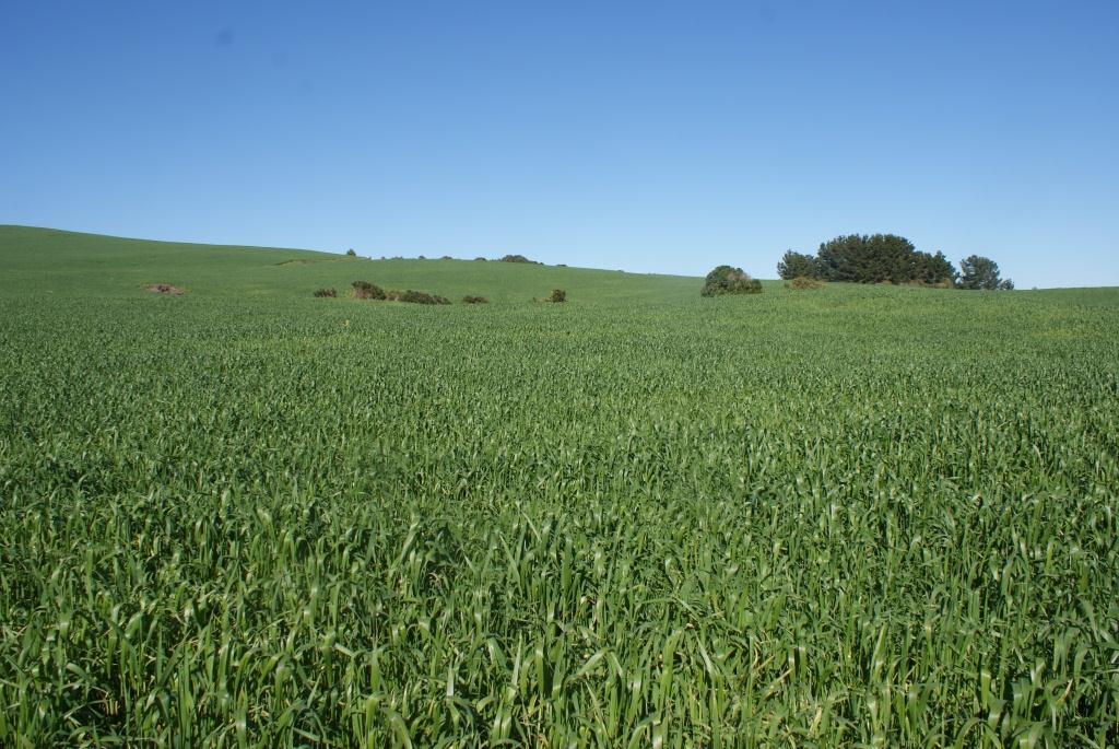
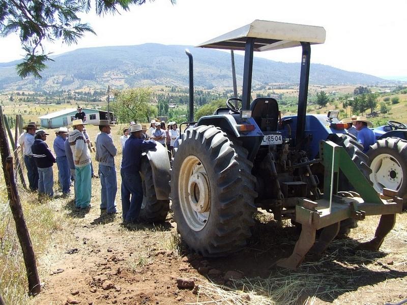
No tillage preceded by subsoiling consists in the use of a subsoiler at a 50 cm depth every 5 years before performing no tillage agriculture.
2.2 การอธิบายแบบละเอียดของเทคโนโลยี
คำอธิบาย:
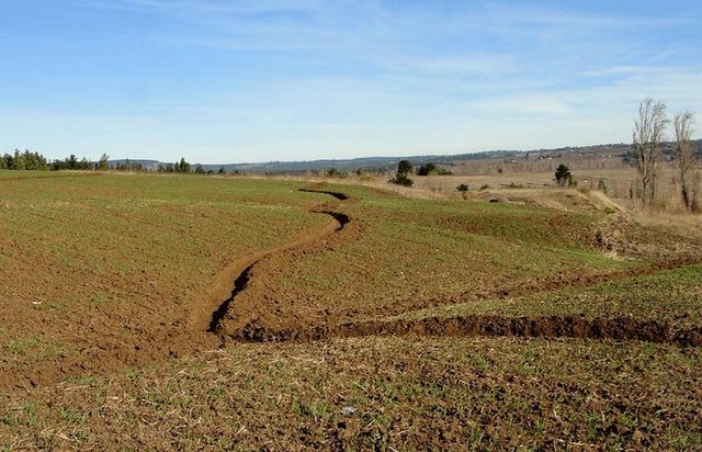
In the “secano interior” of the Mediterranean climate area of central Chile, water erosion and inappropriate agricultural systems along hillslopes are the major causes of soil degradation.
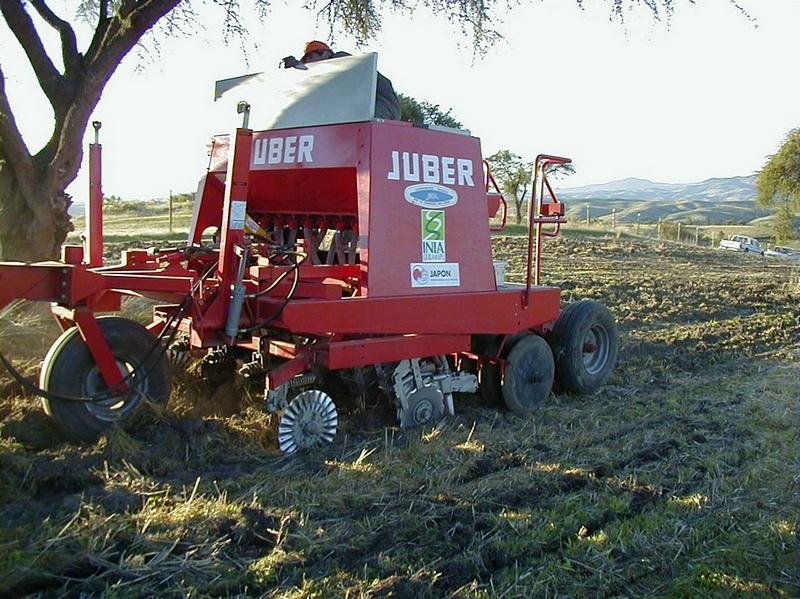
Subsoil tillage is performed with a three-pointed 50-cm chisel plough (see photo), without turning the soil. Subsoiling is needed every five years to break the hard pan after soil compaction. Then crops are directly seeded without any tillage and with stubble left on the field.
Purpose of the Technology: Subsoiling before zero tillage agriculture mitigates water erosion compared to the traditional tillage. In heavy rainfall events, zero tillage reduced soil loss by more than 72% compared to conventional tillage. In addition, the runoff coefficient during the rainy period was 70% lower with zero tillage These results show the importance of conservation tillage and crop stubble management for decreasing erosion, especially in years when extreme rainfall events lead to a high potential for soil erosion. In relation to soil compaction, comparing the resistance to penetration in the soil profile, the traditional tillage system showed a strongly compacted layer at a depth of 10 cm (>1300 kPa), which increased to over 2000 kPa at depths of 15-20 cm. In contrast, no tillage preceded by subsoiling showed less compaction, beyond 20 cm below the threshold of 2000 kPa, defined by several authors as the critical threshold for radicular growth. Moreover, cereal production showed higher biomass and grain yield. It is concluded that subsoiling before no tillage agriculture with stubble retained on the surface was the best option to mitigate soil erosion.
Establishment / maintenance activities and inputs: The main disadvantage of the system is that the farmer requires more capital to lease machinery, which in the traditional system is done with animal traction, and the horses or oxen are from their own property. However, the improved yield covers the machinery lease costs. Additionally, the system pushes small farmers into co-operatives, because it is not possible for everyone to own the equipment. To resolve this problem the project promoted the creation of small enterprises (of 10 people) to jointly purchase no-tillage machinery.
Natural / human environment: The area has a subhumid Mediterranean climate with an average annual precipitation of 695 mm (80% concentrated in winter), with five months of drought. Soils are Alfisols of the Cauquenes type, classified as Ultic Palexeralfs. The soil is made up of materials of granite origin with moderate acidic conditions and low organic carbon. Soil clay content is 15% between 0 and 18 cm depth, below this depth it is higher than 44%. Topography is a hillside with 10 to 20 % slope and the main traditional crop rotation is oat-wheat or wheat-natural pasture.
2.3 รูปภาพของเทคโนโลยี
อัลบั้มสื่อบันทึก
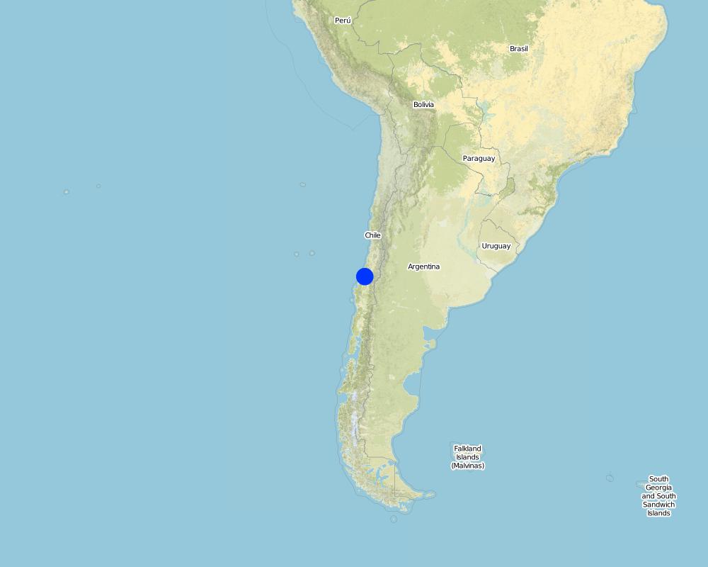
2.5 ประเทศภูมิภาค หรือสถานที่ตั้งที่เทคโนโลยีได้นำไปใช้และได้รับการครอบคลุมโดยการประเมินนี้
ประเทศ:
ชิลี
ภูมิภาค/รัฐ/จังหวัด:
Bíobio and Maule region
ข้อมูลจำเพาะเพิ่มเติมของสถานที่ตั้ง :
Cauquenes
ระบุการกระจายตัวของเทคโนโลยี:
- กระจายไปอย่างสม่ำเสมอในพื้นที่
If the Technology is evenly spread over an area, specify area covered (in km2):
10.0
แสดงความคิดเห็น:
Total area covered by the SLM Technology is 10 sq km.
Map
×2.6 วันที่การดำเนินการ
ถ้าไม่รู้ปีที่แน่นอน ให้ระบุวันที่โดยประมาณ:
- น้อยกว่า 10 ปี (ไม่นานนี้)
2.7 คำแนะนำของเทคโนโลยี
ให้ระบุว่าเทคโนโลยีถูกแนะนำเข้ามาอย่างไร:
- ทางโครงการหรือจากภายนอก
3. การจัดประเภทของเทคโนโลยี SLM
3.1 วัตถุประสงค์หลักของเทคโนโลยี
- ลด ป้องกัน ฟื้นฟู การเสื่อมโทรมของที่ดิน
3.2 ประเภทของการใช้ที่ดินในปัจจุบันที่ได้นำเทคโนโลยีไปใช้
Land use mixed within the same land unit:
ใช่
Specify mixed land use (crops/ grazing/ trees):
- การปลูกพืชร่วมกับปศุสัตว์และการทำป่าไม้ (Agro-silvopastoralism)

พื้นที่ปลูกพืช
- การปลูกพืชล้มลุกอายุปีเดียว
- การปลูกพืชยืนต้นที่ไม่มีเนื้อไม้
- การปลูกไม้ยืนต้น ไม้พุ่ม
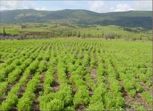
Annual cropping - Specify crops:
- legumes and pulses - other
- wheat, lentils
Tree and shrub cropping - Specify crops:
- grapes
จำนวนของฤดูเพาะปลูกต่อปี:
- 1
ระบุ:
Longest growing period in days: 300; Longest growing period from month to month: Mar-Nov
Is crop rotation practiced?
ใช่
ถ้าใช่ ระบุ:
Crop rotation lentil-wheat in no tillage

ทุ่งหญ้าเลี้ยงสัตว์
Animal type:
- sheep
แสดงความคิดเห็น:
major crop: Wheat, lentil and vineyards
Major land use problems (compiler’s opinion): The soil shows severe water erosion. 75% of the area has slope over 15% and most soils are moderately to severely eroded. Soils with low infiltration (only 4%) are very compacted, because of agricultural practices.
Major land use problems (land users’ perception): The soil presents a severe water erosion.
Mixed: (eg agro-pastoralism, silvo-pastoralism): sheep
Livestock is grazing on crop residues
3.3 Has land use changed due to the implementation of the Technology?
Has land use changed due to the implementation of the Technology?
- Yes (Please fill out the questions below with regard to the land use before implementation of the Technology)
พื้นที่ปลูกพืช
- การปลูกพืชล้มลุกอายุปีเดียว
3.4 การใช้น้ำ
การใช้น้ำของที่ดินที่มีการใช้เทคโนโลยีอยู่:
- จากน้ำฝน
3.5 กลุ่ม SLM ที่ตรงกับเทคโนโลยีนี้
- การรบกวนดินให้น้อยที่สุด
3.6 มาตรการ SLM ที่ประกอบกันเป็นเทคโนโลยี

มาตรการจัดการพืช
- A4: การรักษาดินชั้นล่าง
แสดงความคิดเห็น:
Type of agronomic measures: cover cropping, mineral (inorganic) fertilizers, breaking compacted topsoil, zero tillage / no-till
3.7 รูปแบบหลักของการเสื่อมโทรมของที่ดินที่ได้รับการแก้ไขโดยเทคโนโลยี

การเสื่อมโทรมของดินทางด้านกายภาพ
- Pc (Compaction): การอัดแน่น
แสดงความคิดเห็น:
Main type of degradation addressed: Pc: compaction
Main causes of degradation: soil management, Heavy / extreme rainfall (intensity/amounts), poverty / wealth, education, access to knowledge and support service
3.8 การป้องกัน การลดลง หรือการฟื้นฟูความเสื่อมโทรมของที่ดิน
ระบุเป้าหมายของเทคโนโลยีกับความเสื่อมโทรมของที่ดิน:
- ป้องกันความเสื่อมโทรมของที่ดิน
- ลดความเสื่อมโทรมของดิน
แสดงความคิดเห็น:
Secondary goals: mitigation / reduction of land degradation
4. ข้อมูลจำเพาะด้านเทคนิค กิจกรรมการนำไปปฏิบัติใช้ ปัจจัยนำเข้า และค่าใช้จ่าย
4.1 แบบแปลนทางเทคนิคของเทคโนโลยี
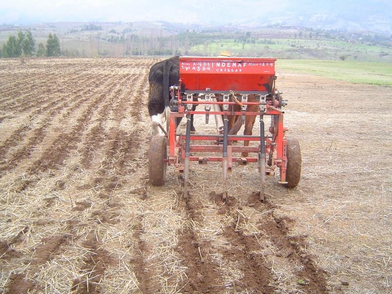
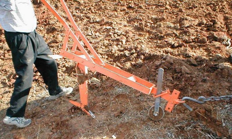
ข้อมูลจำเพาะด้านเทคนิค (แบบแปลนทางเทคนิคของเทคโนโลยี):
Photo of subsoiling drill.
The subsoiler is a 3-point chisel plough that breaks up the soil hardpan to a depth of 30 to 50 cm.
Location: Bíobio and Maule Region. Cauquenes, Chile
Date: 2007
Technical knowledge required for land users: high
Main technical functions: improvement of topsoil structure (compaction), increase of infiltration, increase / maintain water stored in soil
Secondary technical functions: control of raindrop splash, control of dispersed runoff: retain / trap, control of dispersed runoff: impede / retard, improvement of ground cover, increase in organic matter
Cover cropping
Material/ species: Wheat straw
Quantity/ density: 2,5 tn/ha
ผู้เขียน:
Carlos Ruiz
4.2 ข้อมูลทั่วไปเกี่ยวกับการคำนวณปัจจัยนำเข้าและค่าใช้จ่าย
ระบุสกุลเงินที่ใช้คำนวณค่าใช้จ่าย:
- USD
4.3 กิจกรรมเพื่อการจัดตั้ง
| กิจกรรม | Timing (season) | |
|---|---|---|
| 1. | No tillage machinery | |
| 2. | Subsoiling every 5 years |
4.4 ค่าใช้จ่ายของปัจจัยนำเข้าที่จำเป็นสำหรับการจัดตั้ง
| ปัจจัยนำเข้า | หน่วย | ปริมาณ | ค่าใช้จ่ายต่อหน่วย | ค่าใช้จ่ายทั้งหมดต่อปัจจัยนำเข้า | %ของค่าใช้จ่ายที่ก่อให้เกิดขึ้นโดยผู้ใช้ที่ดิน | |
|---|---|---|---|---|---|---|
| แรงงาน | Subsoiling | unit | 1.0 | 50.0 | 50.0 | 100.0 |
| อุปกรณ์ | Renting seeder machine | unit | 1.0 | 60.0 | 60.0 | |
| อุปกรณ์ | Renting subsoiling machine | unit | 1.0 | 70.0 | 70.0 | |
| ค่าใช้จ่ายทั้งหมดของการจัดตั้งเทคโนโลยี | 180.0 | |||||
| Total costs for establishment of the Technology in USD | 180.0 | |||||
4.5 การบำรุงรักษาสภาพหรือกิจกรรมที่เกิดขึ้นเป็นประจำ
| กิจกรรม | ช่วงระยะเวลา/ความถี่ | |
|---|---|---|
| 1. | Herbicide application | |
| 2. | Seeding | |
| 3. | Fertilization |
4.6 ค่าใช้จ่ายของปัจจัยนำเข้าและกิจกรรมที่เกิดขึ้นเป็นประจำที่ต้องการการบำรุงรักษา (ต่อปี)
| ปัจจัยนำเข้า | หน่วย | ปริมาณ | ค่าใช้จ่ายต่อหน่วย | ค่าใช้จ่ายทั้งหมดต่อปัจจัยนำเข้า | %ของค่าใช้จ่ายที่ก่อให้เกิดขึ้นโดยผู้ใช้ที่ดิน | |
|---|---|---|---|---|---|---|
| แรงงาน | Herbicide application | unit | 1.0 | 20.0 | 20.0 | |
| อุปกรณ์ | Renting seeder machine | unit | 1.0 | 60.0 | 60.0 | |
| วัสดุด้านพืช | Seeds | unit | 1.0 | 50.0 | 50.0 | |
| ปุ๋ยและสารฆ่า/ยับยั้งการเจริญเติบโตของสิ่งมีชีวิต (ไบโอไซด์) | Fertilizer | unit | 1.0 | 174.0 | 174.0 | |
| ปุ๋ยและสารฆ่า/ยับยั้งการเจริญเติบโตของสิ่งมีชีวิต (ไบโอไซด์) | Herbicide | unit | 1.0 | 20.0 | 20.0 | |
| ค่าใช้จ่ายทั้งหมดของการบำรุงรักษาสภาพเทคโนโลยี | 324.0 | |||||
| Total costs for maintenance of the Technology in USD | 324.0 | |||||
แสดงความคิดเห็น:
Machinery/ tools: Animal traction and No tillage machine
4.7 ปัจจัยสำคัญที่สุดที่มีผลกระทบต่อค่าใช้จ่าย
ปัจจัยสำคัญที่สุดที่มีผลกระทบต่อค่าใช้จ่ายต่างๆ:
Availability of machinery is the most determining factor affecting the costs.
5. สิ่งแวดล้อมทางธรรมชาติและของมนุษย์
5.1 ภูมิอากาศ
ฝนประจำปี
- < 250 ม.ม.
- 251-500 ม.ม.
- 501-750 ม.ม.
- 751-1,000 ม.ม.
- 1,001-1,500 ม.ม.
- 1,501-2,000 ม.ม.
- 2,001-3,000 ม.ม.
- 3,001-4,000 ม.ม.
- > 4,000 ม.ม.
ข้อมูลจำเพาะ/ความคิดเห็นเรื่องปริมาณน้ำฝน:
80% rainfall between May - August
เขตภูมิอากาศเกษตร
- กึ่งชุ่มชื้น
Thermal climate class: temperate
5.2 สภาพภูมิประเทศ
ค่าเฉลี่ยความลาดชัน:
- ราบเรียบ (0-2%)
- ลาดที่ไม่ชัน (3-5%)
- ปานกลาง (6-10%)
- เป็นลูกคลื่น (11-15%)
- เป็นเนิน (16-30%)
- ชัน (31-60%)
- ชันมาก (>60%)
ธรณีสัณฐาน:
- ที่ราบสูง/ที่ราบ
- สันเขา
- ไหล่เขา
- ไหล่เนินเขา
- ตีนเนิน
- หุบเขา
ระดับความสูง:
- 0-100 เมตร
- 101-500 เมตร
- 501-1,000 เมตร
- 1,001-1,500 เมตร
- 1,501-2,000 เมตร
- 2,001-2,500 เมตร
- 2,501-3,000 เมตร
- 3,001-4,000 เมตร
- > 4,000 เมตร
5.3 ดิน
ค่าเฉลี่ยความลึกของดิน:
- ตื้นมาก (0-20 ซ.ม.)
- ตื้น (21-50 ซ.ม.)
- ลึกปานกลาง (51-80 ซ.ม.)
- ลึก (81-120 ซ.ม.)
- ลึกมาก (>120 ซ.ม.)
เนื้อดิน (ดินชั้นบน):
- ปานกลาง (ดินร่วน ทรายแป้ง)
อินทรียวัตถุในดิน:
- ต่ำ (<1%)
(ถ้ามี) ให้แนบคำอธิบายเรื่องดินแบบเต็มหรือระบุข้อมูลที่มีอยู่ เช่น ชนิดของดิน ค่า pH ของดินหรือความเป็นกรดของดิน ความสามารถในการแลกเปลี่ยนประจุบวก ไนโตรเจน ความเค็ม เป็นต้น:
Soil fertility is very low
Soil drainage / infiltration is good
Soil water storage capacity is low
5.4 ความเป็นประโยชน์และคุณภาพของน้ำ
ระดับน้ำใต้ดิน:
5-50 เมตร
น้ำไหลบ่าที่ผิวดิน:
ไม่ดีหรือไม่มีเลย
คุณภาพน้ำ (ที่ยังไม่ได้บำบัด):
เป็นน้ำเพื่อการดื่มที่ดี
5.5 ความหลากหลายทางชีวภาพ
ความหลากหลายทางชนิดพันธุ์:
- ปานกลาง
5.6 ลักษณะของผู้ใช้ที่ดินที่นำเทคโนโลยีไปปฏิบัติใช้
แนวทางการตลาดของระบบการผลิต:
- mixed (subsistence/ commercial)
รายได้ที่มาจากนอกฟาร์ม:
- 10-50% ของรายได้ทั้งหมด
ระดับของความมั่งคั่งโดยเปรียบเทียบ:
- จน
เป็นรายบุคคล/ครัวเรือน:
- เป็นรายบุคคล/ครัวเรือน
ระดับของการใช้เครื่องจักรกล:
- การใช้กำลังจากสัตว์
- การใช้เครื่องจักรหรือเครื่องยนต์
เพศ:
- ชาย
ระบุลักษณะอื่นๆที่เกี่ยวข้องของผู้ใช้ที่ดิน:
Land users applying the Technology are mainly Leaders / privileged
Population density: 10-50 persons/km2
Annual population growth: < 0.5%
and own 60% of the land.
5.7 Average area of land used by land users applying the Technology
- < 0.5 เฮกตาร์
- 0.5-1 เฮกตาร์
- 1-2 เฮกตาร์
- 2-5 เฮกตาร์
- 5-15 เฮกตาร์
- 15-50 เฮกตาร์
- 50-100 เฮกตาร์
- 100-500 เฮกตาร์
- 500-1,000 เฮกตาร์
- 1,000-10,000 เฮกตาร์
- >10,000 เฮกตาร์
พิจารณาว่าเป็นขนาดเล็ก กลาง หรือขนาดใหญ่ (ซึ่งอ้างอิงถึงบริบทระดับท้องถิ่น):
- ขนาดเล็ก
5.8 กรรมสิทธิ์ในที่ดิน สิทธิในการใช้ที่ดินและสิทธิในการใช้น้ำ
กรรมสิทธิ์ในที่ดิน:
- รายบุคคล ได้รับสิทธิครอบครอง
สิทธิในการใช้ที่ดิน:
- รายบุคคล
สิทธิในการใช้น้ำ:
- รายบุคคล
5.9 การเข้าถึงบริการและโครงสร้างพื้นฐาน
สุขภาพ:
- จน
- ปานกลาง
- ดี
การศึกษา:
- จน
- ปานกลาง
- ดี
ความช่วยเหลือทางด้านเทคนิค:
- จน
- ปานกลาง
- ดี
การจ้างงาน (เช่น ภายนอกฟาร์ม):
- จน
- ปานกลาง
- ดี
พลังงาน:
- จน
- ปานกลาง
- ดี
ถนนและการขนส่ง:
- จน
- ปานกลาง
- ดี
น้ำดื่มและการสุขาภิบาล:
- จน
- ปานกลาง
- ดี
บริการด้านการเงิน:
- จน
- ปานกลาง
- ดี
6. ผลกระทบและสรุปคำบอกกล่าว
6.1 ผลกระทบในพื้นที่ดำเนินการ (On-site) จากการใช้เทคโนโลยี
ผลกระทบทางด้านเศรษฐกิจและสังคม
การผลิต
การผลิตพืชผล
การเสี่ยงต่อความล้มเหลวในการผลิต
การจัดการที่ดิน
รายได้และค่าใช้จ่าย
ค่าใช่จ่ายของปัจจัยการผลิตทางการเกษตร
รายได้จากฟาร์ม
ภาระงาน
ผลกระทบด้านสังคมวัฒนธรรมอื่น ๆ
ความมั่นคงด้านอาหาร / พึ่งตนเองได้
สถาบันของชุมชน
SLM หรือความรู้เรื่องความเสื่อมโทรมของที่ดิน
livelihood and human well-being
แสดงความคิดเห็น/ระบุ:
mproved tillage improves crop yields and thus household income increases
ผลกระทบด้านนิเวศวิทยา
วัฐจักรน้ำหรือน้ำบ่า
น้ำไหลบ่าที่ผิวดิน
ดิน
สิ่งปกคลุมดิน
การสูญเสียดิน
การเกิดแผ่นแข็งที่ผิวดิน /การเกิดชั้นดาน
การอัดแน่นของดิน
การหมุนเวียนและการเติมของธาตุอาหาร
อินทรียวัตถุในดิน/ต่ำกว่าดินชั้น C
ความหลากหลายทางชีวภาพของพืชและสัตว์
มวลชีวภาพ/เหนือดินชั้น C
6.2 ผลกระทบนอกพื้นที่ดำเนินการ (Off-site) จากการใช้เทคโนโลยี
น้ำที่ใช้ประโยชน์ได้
6.3 การเผชิญและความตอบสนองของเทคโนโลยีต่อการเปลี่ยนแปลงสภาพภูมิอากาศที่ค่อยเป็นค่อยไป และสภาพรุนแรงของภูมิอากาศ / ภัยพิบัติ (ที่รับรู้ได้โดยผู้ใช้ที่ดิน)
การเปลี่ยนแปลงสภาพภูมิอากาศที่ค่อยเป็นค่อยไป
การเปลี่ยนแปลงสภาพภูมิอากาศที่ค่อยเป็นค่อยไป
| ฤดู | increase or decrease | เทคโนโลยีมีวิธีการรับมืออย่างไร | |
|---|---|---|---|
| อุณหภูมิประจำปี | เพิ่มขึ้น | ดี |
สภาพรุนแรงของภูมิอากาศ (ภัยพิบัติ)
ภัยพิบัติทางอุตุนิยมวิทยา
| เทคโนโลยีมีวิธีการรับมืออย่างไร | |
|---|---|
| พายุฝนประจำท้องถิ่น | ดี |
ภัยพิบัติจากสภาพภูมิอากาศ
| เทคโนโลยีมีวิธีการรับมืออย่างไร | |
|---|---|
| ภัยจากฝนแล้ง | ไม่ค่อยดี |
แสดงความคิดเห็น:
It is necessary to realize subsoiling to improve the yields
6.4 การวิเคราะห์ค่าใช้จ่ายและผลประโยชน์ที่ได้รับ
ผลประโยชน์ที่ได้รับเปรียบเทียบกับค่าใช้จ่ายในการจัดตั้งเป็นอย่างไร (จากมุมมองของผู้ใช้ที่ดิน)
ผลตอบแทนระยะสั้น:
ด้านบวก
ผลตอบแทนระยะยาว:
ด้านบวก
ผลประโยชน์ที่ได้รับเปรียบเทียบกับค่าใช้จ่ายในการบำรุงรักษาหรือต้นทุนที่เกิดขึ้นซ้ำอีก เป็นอย่างไร (จากมุมมองของผู้ใช้ที่ดิน)
ผลตอบแทนระยะสั้น:
ด้านบวก
ผลตอบแทนระยะยาว:
ด้านบวก
6.5 การปรับตัวของเทคโนโลยี
- 11-50%
ถ้ามีข้อมูลให้บอกปริมาณด้วย (จำนวนของครัวเรือนหรือครอบคลุมพื้นที่):
100 households
Of all those who have adopted the Technology, how many did so spontaneously, i.e. without receiving any material incentives/ payments?
- 0-10%
แสดงความคิดเห็น:
100% of land user families have adopted the Technology with external material support
100 land user families have adopted the Technology with external material support
There is no trend towards spontaneous adoption of the Technology
6.7 จุดแข็ง / ข้อได้เปรียบ / โอกาสของเทคโนโลยี
| จุดแข็ง / ข้อได้เปรียบ / โอกาสในทัศนคติของผู้รวบรวมหรือวิทยากรหลัก |
|---|
|
No tillage preceded by subsoiling as part of the incentive programme for the recovery of degraded soils managed by the Agriculture and Livestock Service (SAG) How can they be sustained / enhanced? Adjusting incentives according to timing of the expenses and investments and also conditioning incentives to the adoption of the technologies |
6.8 จุดอ่อน / ข้อเสียเปรียบ / ความเสี่ยงของเทคโนโลยีและวิธีการแก้ไข
| จุดอ่อน / ข้อเสียเปรียบ / ความเสี่ยงในทัศนคติของผู้รวบรวมหรือวิทยากรหลัก | มีวิธีการแก้ไขได้อย่างไร |
|---|---|
| The availability of machines is the main obstacle for adopting zero tillage and subsoiling | To create and promote small companies of agricultural machinery, managed by farmers themselves. Two examples already exist in the counties of San Carlos and Ninhue. |
7. การอ้างอิงและการเชื่อมต่อ
7.1 วิธีการและแหล่งข้อมูล
7.2 การอ้างอิงถึงสิ่งตีพิมพ์
หัวข้อ, ผู้เขียน, ปี, หมายเลข ISBN:
www.inia.cl/link.cgi/GEAM
หัวข้อ, ผู้เขียน, ปี, หมายเลข ISBN:
www.inia.cl/proyectocadepa
หัวข้อ, ผู้เขียน, ปี, หมายเลข ISBN:
- Del Pozo, A., Del Canto, P. 1999. Areas agroclimaticas y sistemas productivos en la VII y VIII Región. (INIA)
ชื่อเรื่อง ผู้เขียน ปี ISBN:
adelpozo@utalca.cl
หัวข้อ, ผู้เขียน, ปี, หมายเลข ISBN:
- Stolpe, Neal. 2006. Descripciones de los principales suelos de la VIII R de Chile. Depto. De Suelos y Rec. Naturales. Universidad de Concepción.
ชื่อเรื่อง ผู้เขียน ปี ISBN:
nstolpe@udec.cl
ลิงก์และโมดูล
ขยายทั้งหมด ย่อทั้งหมดลิงก์
Dissemination of soil conservation technologies in dryland areas [ชิลี]
Dissemination of no tillage with subsoiling in the Municipality of Yumbel
- ผู้รวบรวม: Carlos Ovalle
โมดูล
ไม่มีโมดูล