Afforestation and Hillside Terracing [เอริเทรีย]
- ผู้สร้างสรรค์:
- การอัพเดท:
- ผู้รวบรวม: Eyob Zeremariam
- ผู้เรียบเรียง: –
- ผู้ตรวจสอบ: Fabian Ottiger, Alexandra Gavilano
technologies_1330 - เอริเทรีย
ดูส่วนย่อย
ขยายทั้งหมด ย่อทั้งหมด1. ข้อมูลทั่วไป
1.2 รายละเอียดที่ติดต่อได้ของผู้รวบรวมและองค์กรที่เกี่ยวข้องในการประเมินและการจัดเตรียมทำเอกสารของเทคโนโลยี
ผู้เชี่ยวชาญ SLM:
Bereket Tsehaye
Toker Integrated Community Development
เอริเทรีย
ชื่อของโครงการซึ่งอำนวยความสะดวกในการทำเอกสารหรือการประเมินเทคโนโลยี (ถ้าเกี่ยวข้อง)
Book project: SLM in Practice - Guidelines and Best Practices for Sub-Saharan Africa (SLM in Practice)ชื่อขององค์กรซึ่งอำนวยความสะดวกในการทำเอกสารหรือการประเมินเทคโนโลยี (ถ้าเกี่ยวข้อง)
Toker Integrated Community Development - เอริเทรียชื่อขององค์กรซึ่งอำนวยความสะดวกในการทำเอกสารหรือการประเมินเทคโนโลยี (ถ้าเกี่ยวข้อง)
Ministry of Agriculture of Eritrea (Ministry of Agriculture of Eritrea) - เอริเทรีย1.3 เงื่อนไขการใช้ข้อมูลที่ได้บันทึกผ่านทาง WOCAT
ผู้รวบรวมและวิทยากรหลักยอมรับเงื่อนไขเกี่ยวกับการใช้ข้อมูลที่ถูกบันทึกผ่านทาง WOCAT:
ใช่
2. การอธิบายลักษณะของเทคโนโลยี SLM
2.1 การอธิบายแบบสั้น ๆ ของเทคโนโลยี
คำจำกัดความของเทคโนโลยี:
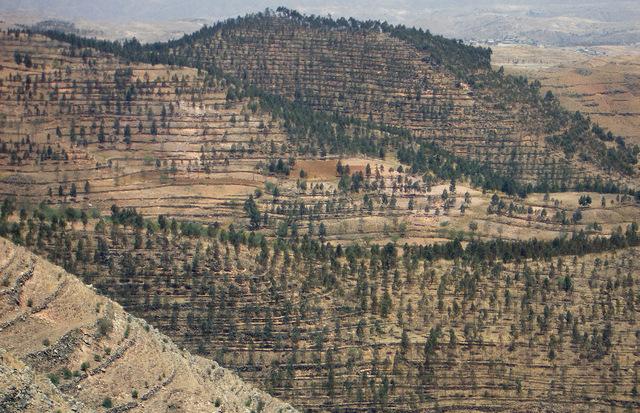
Tree plantations in combination with hillside terracing to protect upper catchment areas are a widespread technology in the Central and Northern Highland Zone of Eritrea.
2.2 การอธิบายแบบละเอียดของเทคโนโลยี
คำอธิบาย:
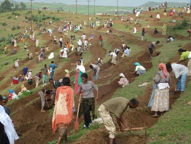
In the early 1990s a large area was treated in the Toker catchment, northwest of Asmara. The first step was to establish hillside terraces on the steeper slopes where it is essential to conserve soil and water for improved growth of trees and other vegetation. The terraces comprise earthen embankments laid out along the along the contour, reinforced with stone risers, combined with a trench on the upper side to harvest runoff water. The trenches are subdivided into basins (by ties) to avoid lateral flow of runoff water. In a second step, trees were planted at a spacing of 2 m (in the trenches). Mostly fast growing eucalyptus was used, with a very small percentage of the indigenous African olive (Olea africana) - which has good survival rates but grows very slowly. Afforested areas are closed for any use until the trees reach maturity: they are protected by guards. In 1995 the Ministry of Agriculture handed over user rights to communities allowing cut-and-carry of grass and cutting of trees (with permission of the government). The technology requires appreciable expense, labor and expertise, but if maintained well, it results in multiple ecological and economic benefits: Soil cover has improved, water is conserved, the severe problems of soil erosion have been reduced, and dams further downstream are protected from siltation. Trees have become an important source of income for the rural communities, wood is a valuable resource mainly needed for construction, and also as fuel. Since the 1960s, several afforestation campaigns have been initiated by the government, mainly using food-for-work or cash-for-work approaches as incentives. Nowadays, local tree planting initiatives (on community or individual level) without external support are dominant.
2.3 รูปภาพของเทคโนโลยี
อัลบั้มสื่อบันทึก
2.5 ประเทศภูมิภาค หรือสถานที่ตั้งที่เทคโนโลยีได้นำไปใช้และได้รับการครอบคลุมโดยการประเมินนี้
ประเทศ:
เอริเทรีย
ภูมิภาค/รัฐ/จังหวัด:
Central Highlands
ข้อมูลจำเพาะเพิ่มเติมของสถานที่ตั้ง :
Serejeka
ระบุการกระจายตัวของเทคโนโลยี:
- กระจายไปอย่างสม่ำเสมอในพื้นที่
If the Technology is evenly spread over an area, specify area covered (in km2):
30.0
แสดงความคิดเห็น:
Total area covered by the SLM Technology is 30 km2.
2.6 วันที่การดำเนินการ
ถ้าไม่รู้ปีที่แน่นอน ให้ระบุวันที่โดยประมาณ:
- 10-50 ปี
2.7 คำแนะนำของเทคโนโลยี
ให้ระบุว่าเทคโนโลยีถูกแนะนำเข้ามาอย่างไร:
- ทางโครงการหรือจากภายนอก
3. การจัดประเภทของเทคโนโลยี SLM
3.1 วัตถุประสงค์หลักของเทคโนโลยี
- ลด ป้องกัน ฟื้นฟู การเสื่อมโทรมของที่ดิน
3.2 ประเภทของการใช้ที่ดินในปัจจุบันที่ได้นำเทคโนโลยีไปใช้

พื้นที่ปลูกพืช
- การปลูกไม้ยืนต้น ไม้พุ่ม
Tree and shrub cropping - Specify crops:
- olive

ป่า/พื้นที่ทำไม้
- ป่า/พื้นที่ทำไม้
Type of tree:
- Eucalyptus species
ผลิตภัณฑ์และบริการ:
- ไม้ซุง
- ไม้ที่นำมาทำเป็นเชื้อเพลิง
- การแทะเล็มหญ้า / การเก็บกินหญ้า
แสดงความคิดเห็น:
Major land use problems (land users’ perception): Surface and gully erosion; Decline of vegetation cover, diversity and biomass; Loss of surface water; Lowering of ground water level
Plantation forestry: Yes
Trees/ shrubs species: Eucalyptus, few Olea africana
3.4 การใช้น้ำ
การใช้น้ำของที่ดินที่มีการใช้เทคโนโลยีอยู่:
- จากน้ำฝน
3.5 กลุ่ม SLM ที่ตรงกับเทคโนโลยีนี้
- การจัดการป่าธรรมชาติและกึ่งธรรมชาติ
- มาตรการปลูกพืชขวางความลาดชัน (cross-slope measure)
3.6 มาตรการ SLM ที่ประกอบกันเป็นเทคโนโลยี

มาตรการอนุรักษ์ด้วยวิธีพืช
- V1: ต้นไม้และพุ่มไม้คลุมดิน

มาตรการอนุรักษ์ด้วยโครงสร้าง
- S1: คันดิน
แสดงความคิดเห็น:
Main measures: vegetative measures, structural measures
Type of vegetative measures: aligned: -contour
3.7 รูปแบบหลักของการเสื่อมโทรมของที่ดินที่ได้รับการแก้ไขโดยเทคโนโลยี

การกัดกร่อนของดินโดยน้ำ
- Wt (Loss of topsoil): การสูญเสียดินชั้นบนหรือการกัดกร่อนที่ผิวดิน
- Wg (Gully erosion): การกัดกร่อนแบบร่องธารหรือการทำให้เกิดร่องน้ำเซาะ

การเสื่อมโทรมของดินทางด้านชีวภาพ
- Bc (Reduction of vegetation cover): การลดลงของจำนวนพืชที่ปกคลุมดิน
- Bq (Quantity/biomass decline): การลดลงของปริมาณหรือมวลชีวภาพ
- Bs (Quality and species composition): องค์ประกอบหรือความหลากหลายทางคุณภาพและชนิดพันธุ์ลดลง

การเสื่อมโทรมของน้ำ
- Hg (Change in groundwater): การเปลี่ยนแปลงของน้ำบาดาลหรือระดับน้ำในแอ่งน้ำบาดาล
แสดงความคิดเห็น:
Main type of degradation addressed: Wt: loss of topsoil / surface erosion, Wg: gully erosion / gullying, Bc: reduction of vegetation cover, Bq: quantity / biomass decline, Bs: quality and species composition /diversity decline, Hg: change in groundwater / aquifer level
3.8 การป้องกัน การลดลง หรือการฟื้นฟูความเสื่อมโทรมของที่ดิน
ระบุเป้าหมายของเทคโนโลยีกับความเสื่อมโทรมของที่ดิน:
- ฟื้นฟูบำบัดที่ดินที่เสื่อมโทรมลงอย่างมาก
4. ข้อมูลจำเพาะด้านเทคนิค กิจกรรมการนำไปปฏิบัติใช้ ปัจจัยนำเข้า และค่าใช้จ่าย
4.1 แบบแปลนทางเทคนิคของเทคโนโลยี
ข้อมูลจำเพาะด้านเทคนิค (แบบแปลนทางเทคนิคของเทคโนโลยี):
Technical knowledge required for field staff / advisors: moderate
Technical knowledge required for land users: high
Main technical functions: control of raindrop splash, control of dispersed runoff: retain / trap, reduction of slope angle, improvement of ground cover, stabilisation of soil (eg by tree roots against land slides), increase of infiltration, increase of groundwater level / recharge of groundwater, increase of biomass (quantity), promotion of vegetation species and varieties (quality, eg palatable fodder)
Aligned: -contour
Vegetative material: T : trees / shrubs
Vertical interval within rows / strips / blocks (m): 2.00
Trees/ shrubs species: Eucalyptus, few Olea africana
Terrace: bench level
Spacing between structures (m): 2.50
Depth of ditches/pits/dams (m): 0.50
Construction material (earth): digging out trenches and piling up risers
Construction material (stone): risers should be reinforced with stones
Vegetation is used for stabilisation of structures.
4.3 กิจกรรมเพื่อการจัดตั้ง
| กิจกรรม | Timing (season) | |
|---|---|---|
| 1. | Dig planting pits (0.5 x 0.5x 0.5 m), at 2 m intervals, in the trenches | |
| 2. | Plant tree seedlings (mainly eucalypts, some African olives); fill pit with top soil (optional: mix with 1 spade of manure) | |
| 3. | Spot weeding and softening soil around the pits to improve percolation of water and soil aeration (during rainy season) | |
| 4. | Supplementary irrigation during dry spells (using jerry / watering cans) | |
| 5. | Prohibit open grazing: Area closure is done collectively | |
| 6. | Mark contour lines using a line level. Spacing between terraces depends on slope, vegetation status, soil depth. In the case study area horizontal spacing between terraces is 2.5 m | |
| 7. | Terraces are built (inward-sloping) by digging out trenches (0.5 m deep) and piling up risers (minimum 0.75 m high). Risers should be reinforced with stones (where available) | |
| 8. | The trenches are separated into basins by ties at an interval of 2-5 m to avoid eventual lateral movement of water |
4.4 ค่าใช้จ่ายของปัจจัยนำเข้าที่จำเป็นสำหรับการจัดตั้ง
| ปัจจัยนำเข้า | หน่วย | ปริมาณ | ค่าใช้จ่ายต่อหน่วย | ค่าใช้จ่ายทั้งหมดต่อปัจจัยนำเข้า | %ของค่าใช้จ่ายที่ก่อให้เกิดขึ้นโดยผู้ใช้ที่ดิน | |
|---|---|---|---|---|---|---|
| แรงงาน | Labour | ha | 1.0 | 1760.0 | 1760.0 | 73.0 |
| อุปกรณ์ | Tools | ha | 1.0 | 50.0 | 50.0 | 73.0 |
| วัสดุด้านพืช | Seedlings | ha | 1.0 | 600.0 | 600.0 | 73.0 |
| ค่าใช้จ่ายทั้งหมดของการจัดตั้งเทคโนโลยี | 2410.0 | |||||
| Total costs for establishment of the Technology in USD | 2410.0 | |||||
4.5 การบำรุงรักษาสภาพหรือกิจกรรมที่เกิดขึ้นเป็นประจำ
| กิจกรรม | ช่วงระยะเวลา/ความถี่ | |
|---|---|---|
| 1. | Replacement of missing plants at onset of rains (10% replacement of seedlings is expected in the 1st year) | onset of rains |
| 2. | Spot weeding and softening soil | |
| 3. | Supplementary irrigation | |
| 4. | Maintenance of structures | before onset of rainy season |
4.6 ค่าใช้จ่ายของปัจจัยนำเข้าและกิจกรรมที่เกิดขึ้นเป็นประจำที่ต้องการการบำรุงรักษา (ต่อปี)
| ปัจจัยนำเข้า | หน่วย | ปริมาณ | ค่าใช้จ่ายต่อหน่วย | ค่าใช้จ่ายทั้งหมดต่อปัจจัยนำเข้า | %ของค่าใช้จ่ายที่ก่อให้เกิดขึ้นโดยผู้ใช้ที่ดิน | |
|---|---|---|---|---|---|---|
| แรงงาน | Labour | ha | 1.0 | 480.0 | 480.0 | 83.0 |
| วัสดุด้านพืช | Seedlings | ha | 1.0 | 100.0 | 100.0 | 83.0 |
| ค่าใช้จ่ายทั้งหมดของการบำรุงรักษาสภาพเทคโนโลยี | 580.0 | |||||
| Total costs for maintenance of the Technology in USD | 580.0 | |||||
แสดงความคิดเห็น:
Costs are calculated for gentle slopes with a terraces spaced at 2.5 m.
4.7 ปัจจัยสำคัญที่สุดที่มีผลกระทบต่อค่าใช้จ่าย
ปัจจัยสำคัญที่สุดที่มีผลกระทบต่อค่าใช้จ่ายต่างๆ:
Labour cost includes construction of hillside terrace, pitting, planting and spot weeding and cultivation. According to the work and payment norms of the Ministry of Agriculture the cost of 1 person-day is 2.66 US$. Production cost of one seedling is 0.2 US$. Maintenance costs include terrace maintenance, re-pitting and replanting of seedlings.
5. สิ่งแวดล้อมทางธรรมชาติและของมนุษย์
5.1 ภูมิอากาศ
ฝนประจำปี
- < 250 ม.ม.
- 251-500 ม.ม.
- 501-750 ม.ม.
- 751-1,000 ม.ม.
- 1,001-1,500 ม.ม.
- 1,501-2,000 ม.ม.
- 2,001-3,000 ม.ม.
- 3,001-4,000 ม.ม.
- > 4,000 ม.ม.
เขตภูมิอากาศเกษตร
- กึ่งแห้งแล้ง
Thermal climate class: tropics
5.2 สภาพภูมิประเทศ
ค่าเฉลี่ยความลาดชัน:
- ราบเรียบ (0-2%)
- ลาดที่ไม่ชัน (3-5%)
- ปานกลาง (6-10%)
- เป็นลูกคลื่น (11-15%)
- เป็นเนิน (16-30%)
- ชัน (31-60%)
- ชันมาก (>60%)
ธรณีสัณฐาน:
- ที่ราบสูง/ที่ราบ
- สันเขา
- ไหล่เขา
- ไหล่เนินเขา
- ตีนเนิน
- หุบเขา
ระดับความสูง:
- 0-100 เมตร
- 101-500 เมตร
- 501-1,000 เมตร
- 1,001-1,500 เมตร
- 1,501-2,000 เมตร
- 2,001-2,500 เมตร
- 2,501-3,000 เมตร
- 3,001-4,000 เมตร
- > 4,000 เมตร
ความคิดเห็นและข้อมูลจำเพาะเพิ่มเติมเรื่องสภาพภูมิประเทศ:
Landforms: Also hill slopes
Slopes on average are steep ( > 50%)
Soil fertility is low
5.3 ดิน
ค่าเฉลี่ยความลึกของดิน:
- ตื้นมาก (0-20 ซ.ม.)
- ตื้น (21-50 ซ.ม.)
- ลึกปานกลาง (51-80 ซ.ม.)
- ลึก (81-120 ซ.ม.)
- ลึกมาก (>120 ซ.ม.)
เนื้อดิน (ดินชั้นบน):
- หยาบ/เบา (ดินทราย)
- ปานกลาง (ดินร่วน ทรายแป้ง)
อินทรียวัตถุในดิน:
- ต่ำ (<1%)
5.6 ลักษณะของผู้ใช้ที่ดินที่นำเทคโนโลยีไปปฏิบัติใช้
แนวทางการตลาดของระบบการผลิต:
- เพื่อการยังชีพ (หาเลี้ยงตนเอง)
- mixed (subsistence/ commercial)
เป็นรายบุคคล/ครัวเรือน:
- กลุ่ม/ชุมชน
ระดับของการใช้เครื่องจักรกล:
- งานที่ใช้แรงกาย
- การใช้กำลังจากสัตว์
ระบุลักษณะอื่นๆที่เกี่ยวข้องของผู้ใช้ที่ดิน:
Land users applying the Technology are mainly disadvantaged land users
Market orientation of production system: subsistence (self-supply), subsistence (self-supply), mixed (subsistence/ commercial, mixed (subsistence/ commercial
5.7 Average area of land used by land users applying the Technology
- < 0.5 เฮกตาร์
- 0.5-1 เฮกตาร์
- 1-2 เฮกตาร์
- 2-5 เฮกตาร์
- 5-15 เฮกตาร์
- 15-50 เฮกตาร์
- 50-100 เฮกตาร์
- 100-500 เฮกตาร์
- 500-1,000 เฮกตาร์
- 1,000-10,000 เฮกตาร์
- >10,000 เฮกตาร์
พิจารณาว่าเป็นขนาดเล็ก กลาง หรือขนาดใหญ่ (ซึ่งอ้างอิงถึงบริบทระดับท้องถิ่น):
- ขนาดเล็ก
5.8 กรรมสิทธิ์ในที่ดิน สิทธิในการใช้ที่ดินและสิทธิในการใช้น้ำ
กรรมสิทธิ์ในที่ดิน:
- รัฐ
สิทธิในการใช้ที่ดิน:
- เกี่ยวกับชุมชน (ถูกจัดระเบียบ)
6. ผลกระทบและสรุปคำบอกกล่าว
6.1 ผลกระทบในพื้นที่ดำเนินการ (On-site) จากการใช้เทคโนโลยี
ผลกระทบทางด้านเศรษฐกิจและสังคม
การผลิต
การผลิตพืชที่ใช้เลี้ยงปศุสัตว์
แสดงความคิดเห็น/ระบุ:
cut-and-carry of grass
การผลิตไม้
รายได้และค่าใช้จ่าย
ความหลากหลายของแหล่งผลิตรายได้
แสดงความคิดเห็น/ระบุ:
selling timber and grass
ผลกระทบด้านสังคมวัฒนธรรมอื่น ๆ
ความมั่นคงด้านอาหาร / พึ่งตนเองได้
โอกาสทางด้านสันทนาการ
สถาบันของชุมชน
SLM หรือความรู้เรื่องความเสื่อมโทรมของที่ดิน
การบรรเทาความขัดแย้ง
ผลกระทบด้านนิเวศวิทยา
วัฐจักรน้ำหรือน้ำบ่า
น้ำไหลบ่าที่ผิวดิน
น้ำบาดาลหรือระดับน้ำในแอ่งน้ำบาดาล
ดิน
ความชื้นในดิน
สิ่งปกคลุมดิน
การสูญเสียดิน
อินทรียวัตถุในดิน/ต่ำกว่าดินชั้น C
ความหลากหลายทางชีวภาพของพืชและสัตว์
มวลชีวภาพ/เหนือดินชั้น C
6.2 ผลกระทบนอกพื้นที่ดำเนินการ (Off-site) จากการใช้เทคโนโลยี
การไหลของน้ำคงที่และสม่ำเสมอในช่วงฤดูแล้ง
น้ำท่วมพื้นที่ท้ายน้ำ
6.3 การเผชิญและความตอบสนองของเทคโนโลยีต่อการเปลี่ยนแปลงสภาพภูมิอากาศที่ค่อยเป็นค่อยไป และสภาพรุนแรงของภูมิอากาศ / ภัยพิบัติ (ที่รับรู้ได้โดยผู้ใช้ที่ดิน)
สภาพรุนแรงของภูมิอากาศ (ภัยพิบัติ)
ภัยพิบัติจากสภาพภูมิอากาศ
| เทคโนโลยีมีวิธีการรับมืออย่างไร | |
|---|---|
| ภัยจากฝนแล้ง | ไม่ค่อยดี |
แสดงความคิดเห็น:
Sensitive to climatic extremes (e.g. rainfall decrease, especially in case of monocultures)
6.4 การวิเคราะห์ค่าใช้จ่ายและผลประโยชน์ที่ได้รับ
ผลประโยชน์ที่ได้รับเปรียบเทียบกับค่าใช้จ่ายในการจัดตั้งเป็นอย่างไร (จากมุมมองของผู้ใช้ที่ดิน)
ผลตอบแทนระยะสั้น:
ด้านลบเล็กน้อย
ผลตอบแทนระยะยาว:
ด้านบวกอย่างมาก
ผลประโยชน์ที่ได้รับเปรียบเทียบกับค่าใช้จ่ายในการบำรุงรักษาหรือต้นทุนที่เกิดขึ้นซ้ำอีก เป็นอย่างไร (จากมุมมองของผู้ใช้ที่ดิน)
ผลตอบแทนระยะสั้น:
เป็นกลางหรือสมดุล
ผลตอบแทนระยะยาว:
ด้านบวก
แสดงความคิดเห็น:
Initial labour inputs payout on long term
6.5 การปรับตัวของเทคโนโลยี
Of all those who have adopted the Technology, how many did so spontaneously, i.e. without receiving any material incentives/ payments?
- 0-10%
แสดงความคิดเห็น:
100% of land user families have adopted the Technology with external material support
There is a moderate trend towards spontaneous adoption of the Technology
Comments on adoption: Acceptance of afforestation areas has increased, since user rights have been given to land users: Communities located in Toker upper catchment areas have taken the initiative to maintain and protect their woodlots. Moreover, there is a trend toward locally initiated hillside terracing and tree planting without external initiative/incentives, apart from the provision of seedlings (through Ministry of Agriculture). The afforestation area covers approx. 30 km2 with high potential to enlarge.
6.7 จุดแข็ง / ข้อได้เปรียบ / โอกาสของเทคโนโลยี
| จุดแข็ง / ข้อได้เปรียบ / โอกาสในทัศนคติของผู้รวบรวมหรือวิทยากรหลัก |
|---|
| Protection of slopes from erosion while at the same time providing an income source for the poor |
6.8 จุดอ่อน / ข้อเสียเปรียบ / ความเสี่ยงของเทคโนโลยีและวิธีการแก้ไข
| จุดอ่อน / ข้อเสียเปรียบ / ความเสี่ยงในทัศนคติของผู้ใช้ที่ดิน | มีวิธีการแก้ไขได้อย่างไร |
|---|---|
| Establishment cost is high and labour intensiv | provision of hand tools and demanded seedlings |
| Fast growing eucalyptus trees have a high rate of water consumption; Indigenous trees are not favoured | encourage people to protect naturally regenerated indigenous trees, assist villagers to get market channels for products of indigenous trees |
| Community mobilization and high knowledge of land users is required | awareness raising campaigns, strengthen village institutional arrangements, assist villages bylaws |
| Land use rights: because the afforestation area is communal, nobody feels responsible for maintenance | promote plantations by individual households |
7. การอ้างอิงและการเชื่อมต่อ
7.2 การอ้างอิงถึงสิ่งตีพิมพ์
หัวข้อ, ผู้เขียน, ปี, หมายเลข ISBN:
Zeremariam I. 2001. Assessment of upper catchment development technologies in the Central High Land zone of Eritrea. MSc Thesis; The Royal Veterinary and Agricultural University, Denmark.
หัวข้อ, ผู้เขียน, ปี, หมายเลข ISBN:
Amanuel Negasi et al. 2002. Soil and water conservation Manual for Eritrea. RELMA.
หัวข้อ, ผู้เขียน, ปี, หมายเลข ISBN:
Zeremariam I.2001. Assessment of upper catchment Development Technologies and Approaches in the Central High Land zone of Eritrea. MSc Thesis; The Royal Veterinary and Agricultural University, Denmark
ลิงก์และโมดูล
ขยายทั้งหมด ย่อทั้งหมดลิงก์
ไม่มีลิงก์
โมดูล
ไม่มีโมดูล