Trees in the riparian area as a protective and aesthetic advantage at Naro Moru River [เคนยา]
- ผู้สร้างสรรค์:
- การอัพเดท:
- ผู้รวบรวม: Manuel Fischer
- ผู้เรียบเรียง: –
- ผู้ตรวจสอบ: David Streiff, Alexandra Gavilano
technologies_1580 - เคนยา
ดูส่วนย่อย
ขยายทั้งหมด ย่อทั้งหมด1. ข้อมูลทั่วไป
1.2 รายละเอียดที่ติดต่อได้ของผู้รวบรวมและองค์กรที่เกี่ยวข้องในการประเมินและการจัดเตรียมทำเอกสารของเทคโนโลยี
ผู้ใช้ที่ดิน:
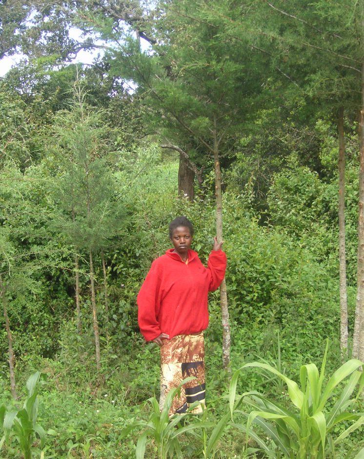
Wanjiru Cecilia
เคนยา
ชื่อขององค์กรซึ่งอำนวยความสะดวกในการทำเอกสารหรือการประเมินเทคโนโลยี (ถ้าเกี่ยวข้อง)
CDE Centre for Development and Environment (CDE Centre for Development and Environment) - สวิตเซอร์แลนด์1.3 เงื่อนไขการใช้ข้อมูลที่ได้บันทึกผ่านทาง WOCAT
ผู้รวบรวมและวิทยากรหลักยอมรับเงื่อนไขเกี่ยวกับการใช้ข้อมูลที่ถูกบันทึกผ่านทาง WOCAT:
ใช่
2. การอธิบายลักษณะของเทคโนโลยี SLM
2.1 การอธิบายแบบสั้น ๆ ของเทคโนโลยี
คำจำกัดความของเทคโนโลยี:
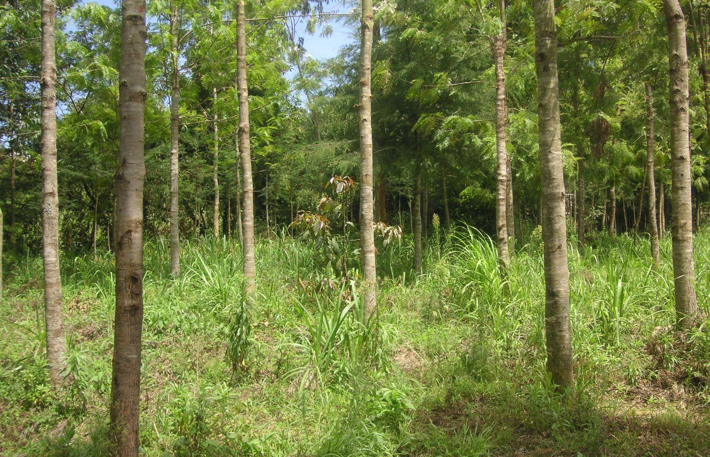
Trees are planted along the riparian zone to stabilize the riverbank and to prevent degradation. The wood can be used to establish a building or to generate income on the market.
2.2 การอธิบายแบบละเอียดของเทคโนโลยี
คำอธิบาย:
At the foot slopes of Mt. Kenya a farmer has developed a technology to protect the own land plot from riverbank erosion. The technology consists of three main measures: A wall along the riverbed, trees that are aligned on the wall as well as beside it and Napier grass wildly scattered between the trees. The wall was built on a highly exposed spot of the riverbank. Trees along and beside the wall ensure its stability. The combination of the two measures results in an effective protection of the riverbank in terms of erosion. Side effects of the technology are higher runoff during the dry season, better water quality due to less erosion and an improved riparian habitat for animals and plants.
Purpose of the Technology: For a small scale farmer, planting of trees can have advantages in an economic, an ecologic and an aesthetic point of view. The trees stabilize the soil, allow the riparian vegetation to establish, and prevent major damages through flooding. Furthermore, there are several advantages of an intact riparian zone, such as enhanced biodiversity, increased water quality as well as retention of agrochemicals. The trees also work as a kind of bank account, since the prices for wood are quite high. Trees can be cut and sold from time to time to generate an income that can be used for further investments like local entrepreneurship or building houses for family members. Last but not least, the farmer emphasized the beautiful appearance of the trees including the relatively cool micro- climate the trees are able to provide during the hot months of the dry period.
Establishment / maintenance activities and inputs: The trees were planted during the rainy season. Braches are pruned regularly and provide mulch material as well as fire wood. When trees are reaching maturity they will selectively be cut and replanted. The Napier grass is cut regularly for fodder to be feed to animals. At this particular time, there is a regular hay yield (weed). Seedlings for trees and the grasses are produced on site. Occasional pruning ensures fuel wood supply.
Natural / human environment: The plot is situated at the western side of Mt. Kenya in its foot zone, a moderate hilly region. Actually, the foot zone is a transition area between the humid mountain forest above elevations of 2500 m.a.s.l and the semi-arid savannah zone below 2000 m a.s.l. Although the region is located in the rain shadow of Mt. Kenya, there is just enough precipitation (740mm) to sustain rain fed agriculture and the farmers even benefit from a water project. During the last decades, the region has experienced a still continuing population growth which increases population pressure in the area. The good accessibility and the moderate tourism allow even off-farm income-generation.
2.3 รูปภาพของเทคโนโลยี
อัลบั้มสื่อบันทึก
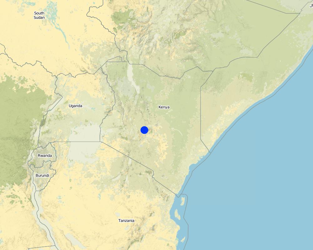
2.5 ประเทศภูมิภาค หรือสถานที่ตั้งที่เทคโนโลยีได้นำไปใช้และได้รับการครอบคลุมโดยการประเมินนี้
ประเทศ:
เคนยา
ภูมิภาค/รัฐ/จังหวัด:
Kenya/Central Province
ข้อมูลจำเพาะเพิ่มเติมของสถานที่ตั้ง :
Naro Moru
ระบุการกระจายตัวของเทคโนโลยี:
- กระจายไปอย่างสม่ำเสมอในพื้นที่
If precise area is not known, indicate approximate area covered:
- < 0.1 ตร.กม.(10 เฮกตาร์)
Map
×2.6 วันที่การดำเนินการ
ถ้าไม่รู้ปีที่แน่นอน ให้ระบุวันที่โดยประมาณ:
- น้อยกว่า 10 ปี (ไม่นานนี้)
2.7 คำแนะนำของเทคโนโลยี
ให้ระบุว่าเทคโนโลยีถูกแนะนำเข้ามาอย่างไร:
- ด้วยการริเริ่มของผู้ใช้ที่ดินเอง
ความคิดเห็น (ประเภทของโครงการ เป็นต้น) :
The land user has enough space to afforest along the riparian. The main goals are to stabilise the riparian soil and to produce wood for use in the future.
3. การจัดประเภทของเทคโนโลยี SLM
3.1 วัตถุประสงค์หลักของเทคโนโลยี
- ปรับปรุงการผลิตให้ดีขึ้น
- ลด ป้องกัน ฟื้นฟู การเสื่อมโทรมของที่ดิน
3.2 ประเภทของการใช้ที่ดินในปัจจุบันที่ได้นำเทคโนโลยีไปใช้
Land use mixed within the same land unit:
ใช่
Specify mixed land use (crops/ grazing/ trees):
- วนเกษตร (Agroforestry)

พื้นที่ปลูกพืช
- การปลูกพืชล้มลุกอายุปีเดียว
Annual cropping - Specify crops:
- fodder crops - grasses
จำนวนของฤดูเพาะปลูกต่อปี:
- 2
ระบุ:
Longest growing period in days: 90 Longest growing period from month to month: april to may Second longest growing period in days: 90 Second longest growing period from month to month: october to november

ป่า/พื้นที่ทำไม้
- ป่า/พื้นที่ทำไม้
Type of tree:
- Cupressus species
- Grevillea robusta
ผลิตภัณฑ์และบริการ:
- ไม้ซุง
- ไม้ที่นำมาทำเป็นเชื้อเพลิง
- การอนุรักษ์ / ป้องกันธรรมชาติ
- นันทนาการ / การท่องเที่ยว
แสดงความคิดเห็น:
Trees/ shrubs species: Cypress, Grevillea, indigenous trees
Fruit trees / shrubs species: Napier grass
Major land use problems (compiler’s opinion): Surface water pollution and riverbank degradation as well as a diminished habitat of riparian flora and fauna.
Major land use problems (land users’ perception): An unstable riparian zone being eroded by the river and unattractive aesthetics.
Problems / comments regarding forest use: The purpose of the forest is mainly in a protective way. Later on, as soon as the trees are large enough, selective felling for construction is planned.
Forest products and services: timber, fuelwood, nature conservation / protection, recreation / tourism
Future (final) land use (after implementation of SLM Technology): Forests / woodlands: Fp: Plantations, afforestations
3.3 Has land use changed due to the implementation of the Technology?
Has land use changed due to the implementation of the Technology?
- Yes (Please fill out the questions below with regard to the land use before implementation of the Technology)
พื้นที่ปลูกพืช
- การปลูกพืชล้มลุกอายุปีเดียว
3.5 กลุ่ม SLM ที่ตรงกับเทคโนโลยีนี้
- การจัดการป่าธรรมชาติและกึ่งธรรมชาติ
- การปรับปรุงดิน / พืชคลุมดิน
3.6 มาตรการ SLM ที่ประกอบกันเป็นเทคโนโลยี

มาตรการอนุรักษ์ด้วยวิธีพืช
- V1: ต้นไม้และพุ่มไม้คลุมดิน

มาตรการอนุรักษ์ด้วยโครงสร้าง
- S6: กำแพง สิ่งกีดขวาง รั้วไม้ รั้วต่างๆ
แสดงความคิดเห็น:
Main measures: vegetative measures
Secondary measures: structural measures
Type of vegetative measures: aligned: -linear, scattered / dispersed
3.7 รูปแบบหลักของการเสื่อมโทรมของที่ดินที่ได้รับการแก้ไขโดยเทคโนโลยี

การกัดกร่อนของดินโดยน้ำ
- Wt (Loss of topsoil): การสูญเสียดินชั้นบนหรือการกัดกร่อนที่ผิวดิน
- Wr (Riverbank erosion): การกัดกร่อนริมฝั่งแม่น้ำ

การเสื่อมโทรมของดินทางด้านชีวภาพ
- Bc (Reduction of vegetation cover): การลดลงของจำนวนพืชที่ปกคลุมดิน
- Bs (Quality and species composition): องค์ประกอบหรือความหลากหลายทางคุณภาพและชนิดพันธุ์ลดลง

การเสื่อมโทรมของน้ำ
- Hp (Decline of surface water quality): การลดลงของคุณภาพน้ำที่ผิวดิน
- Hw (Reduction of the buffering capacity of wetland): การลดลงของความทนทานต่อการเปลี่ยนแปลง ของพื้นที่ชุ่มน้ำ
แสดงความคิดเห็น:
Main type of degradation addressed: Wr: riverbank erosion, Bs: quality and species composition /diversity decline, Hp: decline of surface water quality
Secondary types of degradation addressed: Wt: loss of topsoil / surface erosion, Bc: reduction of vegetation cover, Hw: reduction of the buffering capacity of wetland areas
Main causes of degradation: deforestation / removal of natural vegetation (incl. forest fires), over-exploitation of vegetation for domestic use, population pressure, education, access to knowledge and support services
Secondary causes of degradation: floods
3.8 การป้องกัน การลดลง หรือการฟื้นฟูความเสื่อมโทรมของที่ดิน
ระบุเป้าหมายของเทคโนโลยีกับความเสื่อมโทรมของที่ดิน:
- ป้องกันความเสื่อมโทรมของที่ดิน
- ลดความเสื่อมโทรมของดิน
แสดงความคิดเห็น:
Secondary goals: mitigation / reduction of land degradation
4. ข้อมูลจำเพาะด้านเทคนิค กิจกรรมการนำไปปฏิบัติใช้ ปัจจัยนำเข้า และค่าใช้จ่าย
4.1 แบบแปลนทางเทคนิคของเทคโนโลยี

ข้อมูลจำเพาะด้านเทคนิค (แบบแปลนทางเทคนิคของเทคโนโลยี):
Indigenous trees, a wall and Napier grass are installed between the agricultural land and the river. The wall prevents erosion at a very endangered spot. The trees and the grass provide fodder and wood.
Location: Naro Moru. Nyeri / Central Province
Technical knowledge required for field staff / advisors: moderate
Technical knowledge required for land users: low
Main technical functions: increase of infiltration, improvement of water quality, buffering / filtering water, sediment retention / trapping, sediment harvesting, stabilization of riverbank by trees and grasses
Secondary technical functions: stabilisation of soil (eg by tree roots against land slides)
Aligned: -linear
Vegetative material: T : trees / shrubs
Number of plants per (ha): 200
Vertical interval between rows / strips / blocks (m): 0
Spacing between rows / strips / blocks (m): 1
Vertical interval within rows / strips / blocks (m): 1.5
Width within rows / strips / blocks (m): 2
Scattered / dispersed
Vegetative material: G : grass
Number of plants per (ha): 800
Trees/ shrubs species: Cypress, Grevillea, indigenous trees
Fruit trees / shrubs species: Napier grass
Wall/ barrier
Height of bunds/banks/others (m): 0.5m
Width of bunds/banks/others (m): 2m
Length of bunds/banks/others (m): 10m
ผู้เขียน:
Manuel Fischer
4.2 ข้อมูลทั่วไปเกี่ยวกับการคำนวณปัจจัยนำเข้าและค่าใช้จ่าย
ให้ระบุว่าค่าใช้จ่ายและปัจจัยนำเข้าได้รับการคำนวณอย่างไร:
- ต่อหน่วยเทคโนโลยี
ระบุสกุลเงินที่ใช้คำนวณค่าใช้จ่าย:
- USD
ระบุค่าเฉลี่ยของค่าจ้างในการจ้างแรงงานต่อวัน:
2.70
4.3 กิจกรรมเพื่อการจัดตั้ง
| กิจกรรม | Timing (season) | |
|---|---|---|
| 1. | Setting up a tree nursery | |
| 2. | Planting seedlings | during rainy season |
| 3. | Establishment of wall |
4.4 ค่าใช้จ่ายของปัจจัยนำเข้าที่จำเป็นสำหรับการจัดตั้ง
| ปัจจัยนำเข้า | หน่วย | ปริมาณ | ค่าใช้จ่ายต่อหน่วย | ค่าใช้จ่ายทั้งหมดต่อปัจจัยนำเข้า | %ของค่าใช้จ่ายที่ก่อให้เกิดขึ้นโดยผู้ใช้ที่ดิน | |
|---|---|---|---|---|---|---|
| แรงงาน | Setting up a tree nursery | Persons/day | 5.0 | 3.3333 | 16.67 | 100.0 |
| แรงงาน | Planting seedlings | Persons/day | 25.0 | 3.3333 | 83.33 | 100.0 |
| แรงงาน | Establishment of wall | Persons/day | 5.0 | 3.3333 | 16.67 | 100.0 |
| ค่าใช้จ่ายทั้งหมดของการจัดตั้งเทคโนโลยี | 116.67 | |||||
| Total costs for establishment of the Technology in USD | 116.67 | |||||
4.5 การบำรุงรักษาสภาพหรือกิจกรรมที่เกิดขึ้นเป็นประจำ
| กิจกรรม | ช่วงระยะเวลา/ความถี่ | |
|---|---|---|
| 1. | Replanting trees that dried up | |
| 2. | Cutting the Napier grass and pruning trees | during the rainy seasons = 4 months a year. 3 times a month |
4.6 ค่าใช้จ่ายของปัจจัยนำเข้าและกิจกรรมที่เกิดขึ้นเป็นประจำที่ต้องการการบำรุงรักษา (ต่อปี)
| ปัจจัยนำเข้า | หน่วย | ปริมาณ | ค่าใช้จ่ายต่อหน่วย | ค่าใช้จ่ายทั้งหมดต่อปัจจัยนำเข้า | %ของค่าใช้จ่ายที่ก่อให้เกิดขึ้นโดยผู้ใช้ที่ดิน | |
|---|---|---|---|---|---|---|
| แรงงาน | Replanting trees | Persons/day | 3.0 | 3.3333 | 10.0 | 100.0 |
| แรงงาน | Cutting the Napier grass and pruning trees | Persons/day | 12.0 | 3.33333 | 40.0 | 100.0 |
| ค่าใช้จ่ายทั้งหมดของการบำรุงรักษาสภาพเทคโนโลยี | 50.0 | |||||
| Total costs for maintenance of the Technology in USD | 50.0 | |||||
แสดงความคิดเห็น:
Establishment has been carried out over a time period of 5 years. Considering this time frame, the establishment costs are smaller than the maintenance costs.
The costs per hectare were calculated for a riparian area with the length of 100 m and a width of 10 m, since hectares are difficult to apply in a riparian context. The determining factor for the costs is labour. In this case, the labour costs are quite high because the seedlings were produced in the own nursery. This explains the high labour costs. Some of the seedlings had to be replanted, because they dried up. The required equipment like a spade is available on nearly every farm or can be borrowed from neighbours and is thus not added to the costs.
5. สิ่งแวดล้อมทางธรรมชาติและของมนุษย์
5.1 ภูมิอากาศ
ฝนประจำปี
- < 250 ม.ม.
- 251-500 ม.ม.
- 501-750 ม.ม.
- 751-1,000 ม.ม.
- 1,001-1,500 ม.ม.
- 1,501-2,000 ม.ม.
- 2,001-3,000 ม.ม.
- 3,001-4,000 ม.ม.
- > 4,000 ม.ม.
ระบุชื่อของสถานีตรวดวัดอากาศที่ใช้อ้างอิงคือ:
NS-Daten Eliza
เขตภูมิอากาศเกษตร
- กึ่งชุ่มชื้น
Thermal climate class: subtropics. source: http://en.climate-data.org/location/103473/
5.2 สภาพภูมิประเทศ
ค่าเฉลี่ยความลาดชัน:
- ราบเรียบ (0-2%)
- ลาดที่ไม่ชัน (3-5%)
- ปานกลาง (6-10%)
- เป็นลูกคลื่น (11-15%)
- เป็นเนิน (16-30%)
- ชัน (31-60%)
- ชันมาก (>60%)
ธรณีสัณฐาน:
- ที่ราบสูง/ที่ราบ
- สันเขา
- ไหล่เขา
- ไหล่เนินเขา
- ตีนเนิน
- หุบเขา
ระดับความสูง:
- 0-100 เมตร
- 101-500 เมตร
- 501-1,000 เมตร
- 1,001-1,500 เมตร
- 1,501-2,000 เมตร
- 2,001-2,500 เมตร
- 2,501-3,000 เมตร
- 3,001-4,000 เมตร
- > 4,000 เมตร
ความคิดเห็นและข้อมูลจำเพาะเพิ่มเติมเรื่องสภาพภูมิประเทศ:
Altitudinal zone: 2020
Slopes on average: Land plot has a slope between 5% and 9%
5.3 ดิน
ค่าเฉลี่ยความลึกของดิน:
- ตื้นมาก (0-20 ซ.ม.)
- ตื้น (21-50 ซ.ม.)
- ลึกปานกลาง (51-80 ซ.ม.)
- ลึก (81-120 ซ.ม.)
- ลึกมาก (>120 ซ.ม.)
อินทรียวัตถุในดิน:
- ปานกลาง (1-3%)
(ถ้ามี) ให้แนบคำอธิบายเรื่องดินแบบเต็มหรือระบุข้อมูลที่มีอยู่ เช่น ชนิดของดิน ค่า pH ของดินหรือความเป็นกรดของดิน ความสามารถในการแลกเปลี่ยนประจุบวก ไนโตรเจน ความเค็ม เป็นต้น:
Soil texture: mixture, because it is not red
Soil fertility is high
Soil drainage / infiltration is good
Soil water storage capacity very low - low
5.4 ความเป็นประโยชน์และคุณภาพของน้ำ
ระดับน้ำใต้ดิน:
<5 เมตร
น้ำไหลบ่าที่ผิวดิน:
ดี
คุณภาพน้ำ (ที่ยังไม่ได้บำบัด):
เป็นน้ำเพื่อการดื่มที่ดี
ความคิดเห็นและข้อมูลจำเพาะเพิ่มเติมเรื่องคุณภาพและปริมาณน้ำ:
Ground water table: <5 mjust along the river, deeper ground water level 50-100m
Water quality (untreated): From a water project
5.5 ความหลากหลายทางชีวภาพ
ความหลากหลายทางชนิดพันธุ์:
- สูง
ความคิดเห็นและข้อมูลจำเพาะเพิ่มเติมของความหลากหลายทางชีวภาพ:
Species diversity: Also medium
5.6 ลักษณะของผู้ใช้ที่ดินที่นำเทคโนโลยีไปปฏิบัติใช้
แนวทางการตลาดของระบบการผลิต:
- เพื่อการยังชีพ (หาเลี้ยงตนเอง)
- mixed (subsistence/ commercial)
รายได้ที่มาจากนอกฟาร์ม:
- < 10% ของรายได้ทั้งหมด
ระดับของความมั่งคั่งโดยเปรียบเทียบ:
- พอมีพอกิน
เป็นรายบุคคล/ครัวเรือน:
- เป็นรายบุคคล/ครัวเรือน
ระดับของการใช้เครื่องจักรกล:
- งานที่ใช้แรงกาย
เพศ:
- หญิง
- ชาย
ระบุลักษณะอื่นๆที่เกี่ยวข้องของผู้ใช้ที่ดิน:
Land users applying the Technology are mainly common / average land users
Difference in the involvement of women and men: A clan uses the land commonly. Besides the base family (mother, father, son), the grandmother and an uncle use parts of the land. All of them apply the protective technologies in the riparian.
Population density: 200-500 persons/km2
5.7 Average area of land used by land users applying the Technology
- < 0.5 เฮกตาร์
- 0.5-1 เฮกตาร์
- 1-2 เฮกตาร์
- 2-5 เฮกตาร์
- 5-15 เฮกตาร์
- 15-50 เฮกตาร์
- 50-100 เฮกตาร์
- 100-500 เฮกตาร์
- 500-1,000 เฮกตาร์
- 1,000-10,000 เฮกตาร์
- >10,000 เฮกตาร์
พิจารณาว่าเป็นขนาดเล็ก กลาง หรือขนาดใหญ่ (ซึ่งอ้างอิงถึงบริบทระดับท้องถิ่น):
- ขนาดเล็ก
แสดงความคิดเห็น:
Average area of land owned or leased by land users applying the Technology: < 0.5 ha for Riparian forest.
5.8 กรรมสิทธิ์ในที่ดิน สิทธิในการใช้ที่ดินและสิทธิในการใช้น้ำ
กรรมสิทธิ์ในที่ดิน:
- รายบุคคล ไม่ได้รับสิทธิครอบครอง
สิทธิในการใช้ที่ดิน:
- รายบุคคล
สิทธิในการใช้น้ำ:
- เกี่ยวกับชุมชน (ถูกจัดระเบียบ)
แสดงความคิดเห็น:
Mostly small scale farmers are using the land.
5.9 การเข้าถึงบริการและโครงสร้างพื้นฐาน
สุขภาพ:
- จน
- ปานกลาง
- ดี
การศึกษา:
- จน
- ปานกลาง
- ดี
ความช่วยเหลือทางด้านเทคนิค:
- จน
- ปานกลาง
- ดี
การจ้างงาน (เช่น ภายนอกฟาร์ม):
- จน
- ปานกลาง
- ดี
ตลาด:
- จน
- ปานกลาง
- ดี
ถนนและการขนส่ง:
- จน
- ปานกลาง
- ดี
น้ำดื่มและการสุขาภิบาล:
- จน
- ปานกลาง
- ดี
บริการด้านการเงิน:
- จน
- ปานกลาง
- ดี
6. ผลกระทบและสรุปคำบอกกล่าว
6.1 ผลกระทบในพื้นที่ดำเนินการ (On-site) จากการใช้เทคโนโลยี
ผลกระทบทางด้านเศรษฐกิจและสังคม
การผลิต
การผลิตพืชผล
การผลิตพืชที่ใช้เลี้ยงปศุสัตว์
แสดงความคิดเห็น/ระบุ:
Napier grass yield has increased
การผลิตไม้
แสดงความคิดเห็น/ระบุ:
Before, there was only little wood production
ผลกระทบด้านสังคมวัฒนธรรมอื่น ๆ
SLM หรือความรู้เรื่องความเสื่อมโทรมของที่ดิน
Aesthetics
ผลกระทบด้านนิเวศวิทยา
วัฐจักรน้ำหรือน้ำบ่า
น้ำไหลบ่าที่ผิวดิน
การระบายน้ำส่วนเกิน
ดิน
สิ่งปกคลุมดิน
การสูญเสียดิน
ความหลากหลายทางชีวภาพของพืชและสัตว์
ชนิดพันธุ์ที่ให้ประโยชน์
ลดความเสี่ยงของภัยพิบัติ
ผลกระทบจากน้ำท่วม
ผลกระทบด้านนิเวศวิทยาอื่น ๆ
Riverbank erosion
6.2 ผลกระทบนอกพื้นที่ดำเนินการ (Off-site) จากการใช้เทคโนโลยี
การไหลของน้ำคงที่และสม่ำเสมอในช่วงฤดูแล้ง
การทับถมของดินตะกอนพื้นที่ท้ายน้ำ
การเกิดมลพิษในน้ำบาดาลหรือแม่น้ำ
ความเสียหายต่อโครงสร้างพื้นฐานของรัฐหรือของเอกชน
6.3 การเผชิญและความตอบสนองของเทคโนโลยีต่อการเปลี่ยนแปลงสภาพภูมิอากาศที่ค่อยเป็นค่อยไป และสภาพรุนแรงของภูมิอากาศ / ภัยพิบัติ (ที่รับรู้ได้โดยผู้ใช้ที่ดิน)
การเปลี่ยนแปลงสภาพภูมิอากาศที่ค่อยเป็นค่อยไป
การเปลี่ยนแปลงสภาพภูมิอากาศที่ค่อยเป็นค่อยไป
| ฤดู | increase or decrease | เทคโนโลยีมีวิธีการรับมืออย่างไร | |
|---|---|---|---|
| อุณหภูมิประจำปี | เพิ่มขึ้น | ดี |
สภาพรุนแรงของภูมิอากาศ (ภัยพิบัติ)
ภัยพิบัติทางอุตุนิยมวิทยา
| เทคโนโลยีมีวิธีการรับมืออย่างไร | |
|---|---|
| พายุฝนประจำท้องถิ่น | ดี |
| พายุลมประจำท้องถิ่น | ดี |
ภัยพิบัติจากสภาพภูมิอากาศ
| เทคโนโลยีมีวิธีการรับมืออย่างไร | |
|---|---|
| ภัยจากฝนแล้ง | ดี |
ภัยพิบัติจากน้ำ
| เทคโนโลยีมีวิธีการรับมืออย่างไร | |
|---|---|
| น้ำท่วมตามปกติ (แม่น้ำ) | ดี |
ผลลัพธ์ตามมาที่เกี่ยวข้องกับภูมิอากาศอื่น ๆ
ผลลัพธ์ตามมาที่เกี่ยวข้องกับภูมิอากาศอื่น ๆ
| เทคโนโลยีมีวิธีการรับมืออย่างไร | |
|---|---|
| ช่วงการปลูกพืชที่ลดลงมา | ดี |
6.4 การวิเคราะห์ค่าใช้จ่ายและผลประโยชน์ที่ได้รับ
ผลประโยชน์ที่ได้รับเปรียบเทียบกับค่าใช้จ่ายในการจัดตั้งเป็นอย่างไร (จากมุมมองของผู้ใช้ที่ดิน)
ผลตอบแทนระยะสั้น:
ด้านลบอย่างมาก
ผลตอบแทนระยะยาว:
ด้านบวกอย่างมาก
ผลประโยชน์ที่ได้รับเปรียบเทียบกับค่าใช้จ่ายในการบำรุงรักษาหรือต้นทุนที่เกิดขึ้นซ้ำอีก เป็นอย่างไร (จากมุมมองของผู้ใช้ที่ดิน)
ผลตอบแทนระยะสั้น:
ด้านลบ
ผลตอบแทนระยะยาว:
ด้านบวกอย่างมาก
6.5 การปรับตัวของเทคโนโลยี
- ครั้งเดียวหรือเป็นการทดลอง
ถ้ามีข้อมูลให้บอกปริมาณด้วย (จำนวนของครัวเรือนหรือครอบคลุมพื้นที่):
1 household
Of all those who have adopted the Technology, how many did so spontaneously, i.e. without receiving any material incentives/ payments?
- 91-100%
แสดงความคิดเห็น:
Comments on acceptance with external material support: The WRUA has been distributing seedlings among the riparian farmers. Quantification is not possible.
100% of land user families have adopted the Technology without any external material support
6.7 จุดแข็ง / ข้อได้เปรียบ / โอกาสของเทคโนโลยี
| จุดแข็ง / ข้อได้เปรียบ / โอกาสในทัศนคติของผู้ใช้ที่ดิน |
|---|
|
There is a recreational aspect of the riparian zone. Especially during hot days the farmer is enjoying the slightly colder temperatures because of the canopy and the cooling stream. The aesthetic aspects of the riparian are also enhanced. How can they be sustained / enhanced? If the canopy of the riparian is maintained, it can serve still as recreation area and convince with beautiful looks. |
|
Long term benefits in terms of wood and timber provided by the trees. How can they be sustained / enhanced? If trees are not chopped too early, they will have a good price on the market. |
|
The maintenance of the riparian is not tiring and still gives a good harvest. How can they be sustained / enhanced? Benefits can be sustained by continuing the management practices. |
|
Diversification: Formerly, there was maize at the river, but it died due to cold temperatures. Forests do not die due to frost. How can they be sustained / enhanced? Every plant has its special needs that should be kept in mind. |
| จุดแข็ง / ข้อได้เปรียบ / โอกาสในทัศนคติของผู้รวบรวมหรือวิทยากรหลัก |
|---|
|
Wood production through selective felling is sustainable. How can they be sustained / enhanced? No widespread felling of trees, only selective intervention. |
|
Fodder production enables the keeping of cattle. How can they be sustained / enhanced? Before dry periods, some fodder should be stored to ensure fodder supplies. |
6.8 จุดอ่อน / ข้อเสียเปรียบ / ความเสี่ยงของเทคโนโลยีและวิธีการแก้ไข
| จุดอ่อน / ข้อเสียเปรียบ / ความเสี่ยงในทัศนคติของผู้ใช้ที่ดิน | มีวิธีการแก้ไขได้อย่างไร |
|---|---|
| There is less crop yield, because an area of the plot was formerly used for maize production and now it is part of the riparian. | The productive and protective benefits of the riparian overcome decreased size of the agricultural plot. |
7. การอ้างอิงและการเชื่อมต่อ
7.1 วิธีการและแหล่งข้อมูล
ลิงก์และโมดูล
ขยายทั้งหมด ย่อทั้งหมดลิงก์
ไม่มีลิงก์
โมดูล
ไม่มีโมดูล