Permeable rock dams [บูร์กินาฟาโซ]
- ผู้สร้างสรรค์:
- การอัพเดท:
- ผู้รวบรวม: Dieter Nill
- ผู้เรียบเรียง: –
- ผู้ตรวจสอบ: Alexandra Gavilano, Fabian Ottiger, Joana Eichenberger
Digues filtrantes (French)
technologies_1617 - บูร์กินาฟาโซ
ดูส่วนย่อย
ขยายทั้งหมด ย่อทั้งหมด1. ข้อมูลทั่วไป
1.2 รายละเอียดที่ติดต่อได้ของผู้รวบรวมและองค์กรที่เกี่ยวข้องในการประเมินและการจัดเตรียมทำเอกสารของเทคโนโลยี
ผู้เชี่ยวชาญ SLM:
Dorlöchter-Sulser Sabine
Misereor
เยอรมนี
ผู้เชี่ยวชาญ SLM:
Mamadou Abdou Sani
Programme d’Appui à l’agriculture Productive (PROMAP)/GIZ
ไนเจอร์
ชื่อของโครงการซึ่งอำนวยความสะดวกในการทำเอกสารหรือการประเมินเทคโนโลยี (ถ้าเกี่ยวข้อง)
Manual of Good Practices in Small Scale Irrigation in the Sahel (GIZ )ชื่อขององค์กรซึ่งอำนวยความสะดวกในการทำเอกสารหรือการประเมินเทคโนโลยี (ถ้าเกี่ยวข้อง)
Deutsche Gesellschaft für Internationale Zusammenarbeit (GIZ) GmbH (GIZ) - เยอรมนีชื่อขององค์กรซึ่งอำนวยความสะดวกในการทำเอกสารหรือการประเมินเทคโนโลยี (ถ้าเกี่ยวข้อง)
Misereor - เยอรมนี1.3 เงื่อนไขการใช้ข้อมูลที่ได้บันทึกผ่านทาง WOCAT
ผู้รวบรวมและวิทยากรหลักยอมรับเงื่อนไขเกี่ยวกับการใช้ข้อมูลที่ถูกบันทึกผ่านทาง WOCAT:
ใช่
1.4 การเปิดเผยเรื่องความยั่งยืนของเทคโนโลยีที่ได้อธิบายไว้
เทคโนโลยีที่ได้อธิบายไว้นี้เป็นปัญหาของความเสื่อมโทรมโทรมของที่ดินหรือไม่ จึงไม่ได้รับการยอมรับว่าเป็นเทคโนโลยีเพื่อการจัดการที่ดินอย่างยั่งยืน:
ไม่ใช่
2. การอธิบายลักษณะของเทคโนโลยี SLM
2.1 การอธิบายแบบสั้น ๆ ของเทคโนโลยี
คำจำกัดความของเทคโนโลยี:
Permeable rock dams serve to restore seriously degraded farmland and forest/rangeland and are used to fill in gullies and control water flow.
2.2 การอธิบายแบบละเอียดของเทคโนโลยี
คำอธิบาย:
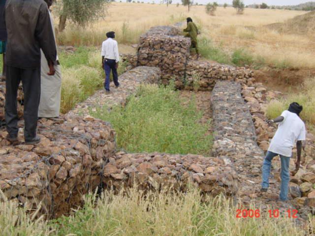
The permeable rock dam is a structure built in gullies using loose rocks and stones and sometimes reinforced with gabions. A filtering layer (blanket of gravel or small stones) is laid in a foundation trench. Further layers of medium-sized and large stones and rocks are laid on top. They are between 0.50 and 3 metres high, and the width of the foundation and the crest depends on the estimated volume of water flow. The structure built across the gully is extended to the sides with the construction of wingwalls that spread the water over a larger area to the sides of the dam. The total width of the structure is generally at least three times its height. The dams can be constructed with or without a spillway. A spillway is required when flood water flow is stronger.
Purpose of the Technology: Permeable rock dams are used to fill in gullies and control water flow. They slow the flow of floodwaters and spread the water over adjacent land. This improves infiltration, and sediment builds up behind the dams. In time, the sediment fills in the gully. This stops lateral drainage from the land on either side, increasing its productivity. High infiltration upstream of the dam contributes to recharging the groundwater system. These structures are therefore also effective in raising the water table in wells and in protecting the bottom-lands from sand filling and gully erosion. They are used in combination with other measures, such as reforestation and stone bunds, to protect and improve the surrounding area, and to increase the area of land that can be used for growing crops.
By dissipating the flow of floodwaters, they ensure better use of rainwater and are therefore important in dry periods. The conservation of water for longer periods and the fine particles of earth trapped by the structure favour the establishment of natural vegetation along it, which helps to stabilise the dam. Seeds are also trapped, favouring the spontaneous growth of grass and trees upstream and downstream, which contributes to restoring and conserving biodiversity.
Establishment / maintenance activities and inputs: The sustainability of permeable rock dams depends on the quality of construction and whether they are maintained regularly. A certain amount of expertise and good community organisation is required to repair any cracks in
the dam. Biological measures (sowing grass and planting trees) increase the stability of the structure.
The size of a permeable rock dam can vary considerably from one site to another. The cost is also affected by the distance of the site from the quarry, the topography of the terrain and the actual amount of rock carried in each lorryload. It costs less to construct this type of structure with loose stones and rocks than with gabions.
2.3 รูปภาพของเทคโนโลยี
อัลบั้มสื่อบันทึก
2.5 ประเทศภูมิภาค หรือสถานที่ตั้งที่เทคโนโลยีได้นำไปใช้และได้รับการครอบคลุมโดยการประเมินนี้
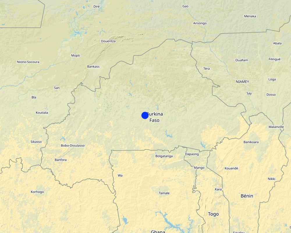
ประเทศ:
บูร์กินาฟาโซ
ภูมิภาค/รัฐ/จังหวัด:
Burkina Faso, Chad
แสดงความคิดเห็น:
Burkina Faso & Chad
Map
×2.6 วันที่การดำเนินการ
ถ้าไม่รู้ปีที่แน่นอน ให้ระบุวันที่โดยประมาณ:
- 10-50 ปี
2.7 คำแนะนำของเทคโนโลยี
ให้ระบุว่าเทคโนโลยีถูกแนะนำเข้ามาอย่างไร:
- ทางโครงการหรือจากภายนอก
ความคิดเห็น (ประเภทของโครงการ เป็นต้น) :
developed, implemented and disseminated as part of projects and programmes undertaken from the 1980s onwards to combat desertification and improve natural resource management. Implemented by GIZ (German Federal Enterprise for International Cooperation), and PATECORE (project for land development and resource conservation in Plateau Central Burkina Faso)
3. การจัดประเภทของเทคโนโลยี SLM
3.1 วัตถุประสงค์หลักของเทคโนโลยี
- ลด ป้องกัน ฟื้นฟู การเสื่อมโทรมของที่ดิน
3.2 ประเภทของการใช้ที่ดินในปัจจุบันที่ได้นำเทคโนโลยีไปใช้
Land use mixed within the same land unit:
ใช่
Specify mixed land use (crops/ grazing/ trees):
- Agro-pastoralism (incl. integrated crop-livestock)

พื้นที่ปลูกพืช
- การปลูกพืชล้มลุกอายุปีเดียว
จำนวนของฤดูเพาะปลูกต่อปี:
- 1
ระบุ:
Longest growing period in days: 120, Longest growing period from month to month: August to October

ทุ่งหญ้าเลี้ยงสัตว์
แสดงความคิดเห็น:
Major land use problems (compiler’s opinion): soil erosion, surface runoff, unfertile land
Constraints of common grazing land
Constraints of forested government-owned land or commons
3.5 กลุ่ม SLM ที่ตรงกับเทคโนโลยีนี้
- มาตรการปลูกพืชขวางความลาดชัน (cross-slope measure)
- การผันน้ำและการระบายน้ำ
- การจัดการน้ำผิวดิน (น้ำพุ แม่น้ำทะเลสาบ ทะเล)
3.6 มาตรการ SLM ที่ประกอบกันเป็นเทคโนโลยี

มาตรการอนุรักษ์ด้วยโครงสร้าง
- S5: เขื่อน ชั้นดินที่แน่นแข็งบ่อน้ำ
3.7 รูปแบบหลักของการเสื่อมโทรมของที่ดินที่ได้รับการแก้ไขโดยเทคโนโลยี

การกัดกร่อนของดินโดยน้ำ
- Wt (Loss of topsoil): การสูญเสียดินชั้นบนหรือการกัดกร่อนที่ผิวดิน
- Wg (Gully erosion): การกัดกร่อนแบบร่องธารหรือการทำให้เกิดร่องน้ำเซาะ
- Wc (Coastal erosion): การกัดเซาะชายฝั่ง

การเสื่อมโทรมของดินทางด้านเคมี
- Cn (Fertility decline): ความอุดมสมบูรณ์และปริมาณอินทรียวัตถุในดินถูกทำให้ลดลงไป (ไม่ได้เกิดจากสาเหตุการกัดกร่อน)

การเสื่อมโทรมของดินทางด้านชีวภาพ
- Bc (Reduction of vegetation cover): การลดลงของจำนวนพืชที่ปกคลุมดิน

การเสื่อมโทรมของน้ำ
- Ha (Aridification): การเกิดความแห้งแล้ง
- Hg (Change in groundwater): การเปลี่ยนแปลงของน้ำบาดาลหรือระดับน้ำในแอ่งน้ำบาดาล
แสดงความคิดเห็น:
Main causes of degradation: soil management (Unadapted land use methods, reduced or abandoned fallow periods), floods, droughts, population pressure (rapidly growing population increasing pressure on land), land tenure (insecure access to land)
3.8 การป้องกัน การลดลง หรือการฟื้นฟูความเสื่อมโทรมของที่ดิน
ระบุเป้าหมายของเทคโนโลยีกับความเสื่อมโทรมของที่ดิน:
- ป้องกันความเสื่อมโทรมของที่ดิน
- ฟื้นฟูบำบัดที่ดินที่เสื่อมโทรมลงอย่างมาก
4. ข้อมูลจำเพาะด้านเทคนิค กิจกรรมการนำไปปฏิบัติใช้ ปัจจัยนำเข้า และค่าใช้จ่าย
4.1 แบบแปลนทางเทคนิคของเทคโนโลยี
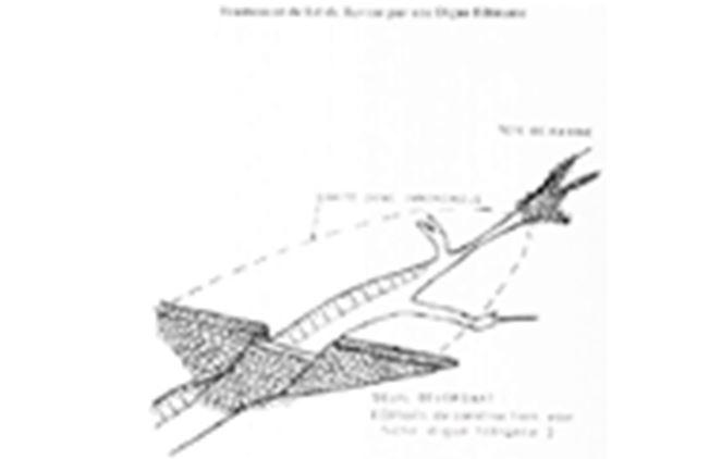
ข้อมูลจำเพาะด้านเทคนิค (แบบแปลนทางเทคนิคของเทคโนโลยี):
Permeable rock dam with spillway
Technical knowledge required for field staff / advisors: moderate
Technical knowledge required for land users: low
Main technical functions: control of dispersed runoff: retain / trap, control of dispersed runoff: impede / retard, control of concentrated runoff: retain / trap, control of concentrated runoff: impede / retard, control of concentrated runoff: drain / divert, stabilisation of soil (eg by tree roots against land slides), increase in nutrient availability (supply, recycling,…), increase of infiltration, increase / maintain water stored in soil, increase of groundwater level / recharge of groundwater, water harvesting / increase water supply, sediment retention / trapping, sediment harvesting
Dam/ pan/ pond
Depth of ditches/pits/dams (m): 0.5-3
Width of ditches/pits/dams (m): 9
ผู้เขียน:
PATECORE
4.7 ปัจจัยสำคัญที่สุดที่มีผลกระทบต่อค่าใช้จ่าย
ปัจจัยสำคัญที่สุดที่มีผลกระทบต่อค่าใช้จ่ายต่างๆ:
The size of a permeable rock dam can vary considerably from one site to another. The cost is also affected by the distance of the site from the quarry, the topography of the terrain and the actual amount of rock carried in each lorryload. The use of gabions also increases the cost considerably.
cost items:
- Topographical surveying
- supply of quarry rock/stones: 113 m3 per 100 linear metres.
- Labour: depends on the size of the dam.
- Transportation by lorry: 23 lorryloads (skip loader – 4.5 m3 per load).
Other costs: Equipment (pickaxes, shovels, wheelbarrows, water-tube level, etc.).
5. สิ่งแวดล้อมทางธรรมชาติและของมนุษย์
5.1 ภูมิอากาศ
ฝนประจำปี
- < 250 ม.ม.
- 251-500 ม.ม.
- 501-750 ม.ม.
- 751-1,000 ม.ม.
- 1,001-1,500 ม.ม.
- 1,501-2,000 ม.ม.
- 2,001-3,000 ม.ม.
- 3,001-4,000 ม.ม.
- > 4,000 ม.ม.
เขตภูมิอากาศเกษตร
- กึ่งแห้งแล้ง
Thermal climate class: subtropics
5.2 สภาพภูมิประเทศ
ค่าเฉลี่ยความลาดชัน:
- ราบเรียบ (0-2%)
- ลาดที่ไม่ชัน (3-5%)
- ปานกลาง (6-10%)
- เป็นลูกคลื่น (11-15%)
- เป็นเนิน (16-30%)
- ชัน (31-60%)
- ชันมาก (>60%)
ธรณีสัณฐาน:
- ที่ราบสูง/ที่ราบ
- สันเขา
- ไหล่เขา
- ไหล่เนินเขา
- ตีนเนิน
- หุบเขา
ระดับความสูง:
- 0-100 เมตร
- 101-500 เมตร
- 501-1,000 เมตร
- 1,001-1,500 เมตร
- 1,501-2,000 เมตร
- 2,001-2,500 เมตร
- 2,501-3,000 เมตร
- 3,001-4,000 เมตร
- > 4,000 เมตร
ความคิดเห็นและข้อมูลจำเพาะเพิ่มเติมเรื่องสภาพภูมิประเทศ:
Slopes on average: Also moderate (6-10%), rolling (11-15%)
Landforms: Also valley floors
Altitudinal zone: Also 1000-1500 m a.s.l.
5.3 ดิน
ค่าเฉลี่ยความลึกของดิน:
- ตื้นมาก (0-20 ซ.ม.)
- ตื้น (21-50 ซ.ม.)
- ลึกปานกลาง (51-80 ซ.ม.)
- ลึก (81-120 ซ.ม.)
- ลึกมาก (>120 ซ.ม.)
เนื้อดิน (ดินชั้นบน):
- ปานกลาง (ดินร่วน ทรายแป้ง)
- ละเอียด/หนัก (ดินเหนียว)
(ถ้ามี) ให้แนบคำอธิบายเรื่องดินแบบเต็มหรือระบุข้อมูลที่มีอยู่ เช่น ชนิดของดิน ค่า pH ของดินหรือความเป็นกรดของดิน ความสามารถในการแลกเปลี่ยนประจุบวก ไนโตรเจน ความเค็ม เป็นต้น:
Soil fertility: Medium and low
Soil drainage/infiltration: Medium and poor
Soil water storage capacity: Medium and low
5.4 ความเป็นประโยชน์และคุณภาพของน้ำ
ระดับน้ำใต้ดิน:
5-50 เมตร
น้ำไหลบ่าที่ผิวดิน:
ปานกลาง
5.5 ความหลากหลายทางชีวภาพ
ความหลากหลายทางชนิดพันธุ์:
- ต่ำ
5.6 ลักษณะของผู้ใช้ที่ดินที่นำเทคโนโลยีไปปฏิบัติใช้
ระดับของความมั่งคั่งโดยเปรียบเทียบ:
- ยากจนมาก
- จน
เพศ:
- ชาย
ระบุลักษณะอื่นๆที่เกี่ยวข้องของผู้ใช้ที่ดิน:
Population density: 10-50 persons/km2
Annual population growth: 3% - 4% (mostly poor households below poverty line).
Off-farm income specification: men migrate temporarily or permanently to cities for off-farm income
5.7 Average area of land used by land users applying the Technology
- < 0.5 เฮกตาร์
- 0.5-1 เฮกตาร์
- 1-2 เฮกตาร์
- 2-5 เฮกตาร์
- 5-15 เฮกตาร์
- 15-50 เฮกตาร์
- 50-100 เฮกตาร์
- 100-500 เฮกตาร์
- 500-1,000 เฮกตาร์
- 1,000-10,000 เฮกตาร์
- >10,000 เฮกตาร์
พิจารณาว่าเป็นขนาดเล็ก กลาง หรือขนาดใหญ่ (ซึ่งอ้างอิงถึงบริบทระดับท้องถิ่น):
- ขนาดเล็ก
5.8 กรรมสิทธิ์ในที่ดิน สิทธิในการใช้ที่ดินและสิทธิในการใช้น้ำ
กรรมสิทธิ์ในที่ดิน:
- รัฐ
สิทธิในการใช้ที่ดิน:
- เกี่ยวกับชุมชน (ถูกจัดระเบียบ)
สิทธิในการใช้น้ำ:
- เกี่ยวกับชุมชน (ถูกจัดระเบียบ)
แสดงความคิดเห็น:
traditional land use rights on fields, common lands on pasture and forest land
5.9 การเข้าถึงบริการและโครงสร้างพื้นฐาน
สุขภาพ:
- จน
- ปานกลาง
- ดี
การศึกษา:
- จน
- ปานกลาง
- ดี
ความช่วยเหลือทางด้านเทคนิค:
- จน
- ปานกลาง
- ดี
การจ้างงาน (เช่น ภายนอกฟาร์ม):
- จน
- ปานกลาง
- ดี
ตลาด:
- จน
- ปานกลาง
- ดี
พลังงาน:
- จน
- ปานกลาง
- ดี
ถนนและการขนส่ง:
- จน
- ปานกลาง
- ดี
น้ำดื่มและการสุขาภิบาล:
- จน
- ปานกลาง
- ดี
บริการด้านการเงิน:
- จน
- ปานกลาง
- ดี
6. ผลกระทบและสรุปคำบอกกล่าว
6.1 ผลกระทบในพื้นที่ดำเนินการ (On-site) จากการใช้เทคโนโลยี
ผลกระทบทางด้านเศรษฐกิจและสังคม
การผลิต
การผลิตพืชผล
การผลิตพืชที่ใช้เลี้ยงปศุสัตว์
การผลิตไม้
พื้นที่สำหรับการผลิต
รายได้และค่าใช้จ่าย
รายได้จากฟาร์ม
ผลกระทบด้านสังคมวัฒนธรรมอื่น ๆ
ความมั่นคงด้านอาหาร / พึ่งตนเองได้
SLM หรือความรู้เรื่องความเสื่อมโทรมของที่ดิน
Improved livelihoods and human well-being
แสดงความคิดเห็น/ระบุ:
As these dams are used in valley bottoms and the beds of seasonal streams to increase infiltration, they can also contribute to raising the water table. Such sites are particularly suitable for horticulture and market gardening, which is important in the off-season. The produce supplements the food available and is an extra source of income.
ผลกระทบด้านนิเวศวิทยา
วัฐจักรน้ำหรือน้ำบ่า
การเก็บเกี่ยวหรือการกักเก็บน้ำ
น้ำไหลบ่าที่ผิวดิน
น้ำบาดาลหรือระดับน้ำในแอ่งน้ำบาดาล
ดิน
ความชื้นในดิน
สิ่งปกคลุมดิน
การสูญเสียดิน
การหมุนเวียนและการเติมของธาตุอาหาร
ความหลากหลายทางชีวภาพของพืชและสัตว์
ความหลากหลายทางชีวภาพของพืช
6.2 ผลกระทบนอกพื้นที่ดำเนินการ (Off-site) จากการใช้เทคโนโลยี
น้ำท่วมพื้นที่ท้ายน้ำ
การทับถมของดินตะกอนพื้นที่ท้ายน้ำ
6.3 การเผชิญและความตอบสนองของเทคโนโลยีต่อการเปลี่ยนแปลงสภาพภูมิอากาศที่ค่อยเป็นค่อยไป และสภาพรุนแรงของภูมิอากาศ / ภัยพิบัติ (ที่รับรู้ได้โดยผู้ใช้ที่ดิน)
การเปลี่ยนแปลงสภาพภูมิอากาศที่ค่อยเป็นค่อยไป
การเปลี่ยนแปลงสภาพภูมิอากาศที่ค่อยเป็นค่อยไป
| ฤดู | increase or decrease | เทคโนโลยีมีวิธีการรับมืออย่างไร | |
|---|---|---|---|
| อุณหภูมิประจำปี | เพิ่มขึ้น | ดี |
สภาพรุนแรงของภูมิอากาศ (ภัยพิบัติ)
ภัยพิบัติทางอุตุนิยมวิทยา
| เทคโนโลยีมีวิธีการรับมืออย่างไร | |
|---|---|
| พายุฝนประจำท้องถิ่น | ไม่ค่อยดี |
| พายุลมประจำท้องถิ่น | ดี |
ภัยพิบัติจากสภาพภูมิอากาศ
| เทคโนโลยีมีวิธีการรับมืออย่างไร | |
|---|---|
| ภัยจากฝนแล้ง | ดี |
ภัยพิบัติจากน้ำ
| เทคโนโลยีมีวิธีการรับมืออย่างไร | |
|---|---|
| น้ำท่วมตามปกติ (แม่น้ำ) | ไม่ค่อยดี |
ผลลัพธ์ตามมาที่เกี่ยวข้องกับภูมิอากาศอื่น ๆ
ผลลัพธ์ตามมาที่เกี่ยวข้องกับภูมิอากาศอื่น ๆ
| เทคโนโลยีมีวิธีการรับมืออย่างไร | |
|---|---|
| ช่วงการปลูกพืชที่ลดลงมา | ดี |
แสดงความคิดเห็น:
Physical structures can be biologically stabilized through planting of grass, bushes or trees. Damages are generally small but need to be repaired quickly.
6.4 การวิเคราะห์ค่าใช้จ่ายและผลประโยชน์ที่ได้รับ
ผลประโยชน์ที่ได้รับเปรียบเทียบกับค่าใช้จ่ายในการจัดตั้งเป็นอย่างไร (จากมุมมองของผู้ใช้ที่ดิน)
ผลตอบแทนระยะสั้น:
ด้านบวก
ผลตอบแทนระยะยาว:
ด้านบวก
ผลประโยชน์ที่ได้รับเปรียบเทียบกับค่าใช้จ่ายในการบำรุงรักษาหรือต้นทุนที่เกิดขึ้นซ้ำอีก เป็นอย่างไร (จากมุมมองของผู้ใช้ที่ดิน)
ผลตอบแทนระยะสั้น:
ด้านบวก
ผลตอบแทนระยะยาว:
ด้านบวกอย่างมาก
6.5 การปรับตัวของเทคโนโลยี
แสดงความคิดเห็น:
There is a little trend towards spontaneous adoption of the Technology
Comments on adoption trend: The potential for replication depends on the type of terrain and whether there is a supply of rocks nearby.
6.7 จุดแข็ง / ข้อได้เปรียบ / โอกาสของเทคโนโลยี
| จุดแข็ง / ข้อได้เปรียบ / โอกาสในทัศนคติของผู้รวบรวมหรือวิทยากรหลัก |
|---|
| Permeable rock dams are used to fill in gullies and control water flow. They slow the flow of floodwaters and spread the water over adjacent land. This improves infiltration, and sediment builds up behind the dams. In time, the sediment fills in the gully which favours the establishment of natural vegetation along it, which helps to stabilise the dam. Seeds are also trapped, favouring the spontaneous growth of grass and trees upstream and downstream, which contributes to restoring and conserving biodiversity. |
| By dissipating floodwater flow, they also contribute to reducing sand filling in valleys further downstream. |
| As these dams are used in valley bottoms and the beds of seasonal streams to increase infiltration, they can also contribute to raising the water table. Such sites are particularly suitable for horticulture and market gardening, which is important in the off-season. The produce supplements the food available and is an extra source of income. |
| increase the area of land that can be used for growing crops |
6.8 จุดอ่อน / ข้อเสียเปรียบ / ความเสี่ยงของเทคโนโลยีและวิธีการแก้ไข
| จุดอ่อน / ข้อเสียเปรียบ / ความเสี่ยงในทัศนคติของผู้รวบรวมหรือวิทยากรหลัก | มีวิธีการแก้ไขได้อย่างไร |
|---|---|
| Depending on the size of the dam, the construction of this type of structure may require a high level of engineering expertise (topographical surveying, calculation of floodwater flow).It also requires a large amount of quarry rocks, which means that the cost of the structure and the labour and transport required is significantly higher than for structures made with stones. As the data required for calculating floodwater flow is often unavailable, the dams must be observed during the first few years, so that they can be reinforced and repaired if necessary. | It is important for farmers to have access to partners providing the necessary know-how, means of transport and support for community organisation. The community must be trained to carry out repair work. |
7. การอ้างอิงและการเชื่อมต่อ
7.1 วิธีการและแหล่งข้อมูล
- ไปเยี่ยมชมภาคสนาม การสำรวจพื้นที่ภาคสนาม
- การสัมภาษณ์กับผู้ใช้ที่ดิน
วันที่เก็บรวบรวมข้อมูล(ภาคสนาม) :
01/07/2012
7.3 Links to relevant online information
ชื่อเรื่องหรือคำอธิบาย:
Good Practices in Soil and Water Conservation. A contribution to adaptation and farmers´ resilience towards climate change in the Sahel. Published by GIZ in 2012.
URL:
http://agriwaterpedia.info/wiki/Main_Page
ลิงก์และโมดูล
ขยายทั้งหมด ย่อทั้งหมดลิงก์
ไม่มีลิงก์
โมดูล
ไม่มีโมดูล