Irrigated agro-biodiversity system in arid high mountain area [Tajikistan]
- Creation:
- Update:
- Compiler: Gulniso Nekushoeva
- Editor: –
- Reviewers: David Streiff, Alexandra Gavilano
technologies_1034 - Tajikistan
View sections
Expand all Collapse all1. General information
1.2 Contact details of resource persons and institutions involved in the assessment and documentation of the Technology
SLM specialist:
SLM specialist:
Name of the institution(s) which facilitated the documentation/ evaluation of the Technology (if relevant)
Tajik Soil Insitute (Tajik Soil Institute) - TajikistanName of the institution(s) which facilitated the documentation/ evaluation of the Technology (if relevant)
CDE Centre for Development and Environment (CDE Centre for Development and Environment) - SwitzerlandName of the institution(s) which facilitated the documentation/ evaluation of the Technology (if relevant)
Tajik Academy of Agricultural Sciences (Tajik Academy of Agricultural Sciences) - Tajikistan1.3 Conditions regarding the use of data documented through WOCAT
The compiler and key resource person(s) accept the conditions regarding the use of data documented through WOCAT:
Yes
2. Description of the SLM Technology
2.1 Short description of the Technology
Definition of the Technology:
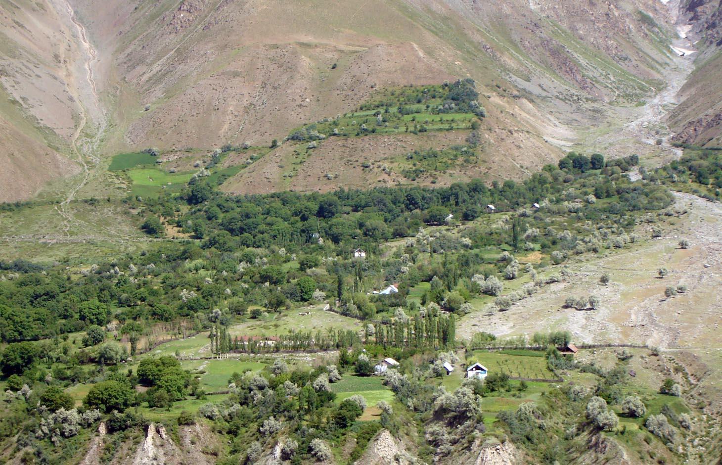
An individual farmer family, has changed an overgrazed pasture area on a steep slope in the upper part of the village into an irrigated agro-biodiversity system, by constructing an irrigation canal, by tilling and removing stones from the terraces for crop production and afforesting the surrounding area with fruit trees and bushes.
2.2 Detailed description of the Technology
Description:
Establishment / maintenance activities and inputs: The site was established in 1989, with the construction of an irrigation canal. The canal brings water from a small watershed and the slowly melting snow fields within. In years with limited snowfall, the water is insufficient for irrigation throughout the summer months.It is a open, mud canal, 730 m long. When establishing new cropland, removal of stones from the plots is the most laborious part of the work. After an initial removal of stones, the land is tilled and appearing stones are again removed. This process is repeated several times.
Year round maintenance work is required to keep the canal functioning. Maintenance work on the cropland includes stone removal, manuring of potatoes fields, weeding and tilling.
2.3 Photos of the Technology
Media Gallery
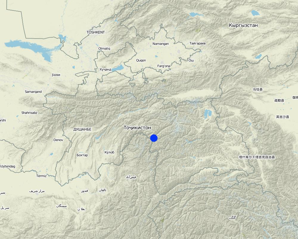
2.5 Country/ region/ locations where the Technology has been applied and which are covered by this assessment
Country:
Tajikistan
Region/ State/ Province:
GBAO
Further specification of location:
Vanj / Udob / Trit
Specify the spread of the Technology:
- evenly spread over an area
If precise area is not known, indicate approximate area covered:
- < 0.1 km2 (10 ha)
Comments:
This technology can be found all along Vanj valley.
Map
×2.6 Date of implementation
If precise year is not known, indicate approximate date:
- more than 50 years ago (traditional)
2.7 Introduction of the Technology
Specify how the Technology was introduced:
- as part of a traditional system (> 50 years)
Comments (type of project, etc.):
A traditional agroforestry system is implemented on a steep slope above the village, as there is a lack of flatter cropland. This requires improved and carefully adapted land practices.
3. Classification of the SLM Technology
3.1 Main purpose(s) of the Technology
- improve production
- conserve ecosystem
3.2 Current land use type(s) where the Technology is applied
Land use mixed within the same land unit:
Yes
Specify mixed land use (crops/ grazing/ trees):
- Agroforestry

Cropland
- Annual cropping
- Perennial (non-woody) cropping
- Tree and shrub cropping
Annual cropping - Specify crops:
- cereals - wheat (spring)
- cereals - wheat (winter)
- fodder crops - alfalfa
- root/tuber crops - potatoes
- vegetables, sea-buckthorn
Tree and shrub cropping - Specify crops:
- pome fruits (apples, pears, quinces, etc.)
- stone fruits (peach, apricot, cherry, plum, etc)
- tree nuts (brazil nuts, pistachio, walnuts, almonds, etc.)
Number of growing seasons per year:
- 1
Specify:
Longest growing period in days: 150Longest growing period from month to month: May - September

Forest/ woodlands
- willow, "sangid", "Jachman bushes", "Kort (big bush)"; withthorn, dog rose
Products and services:
- Fruits and nuts
Comments:
Major land use problems (compiler’s opinion): Water scarcity is the major factor limiting vegetation growth and agricultural production in this arid areas. The soils are stony and slopes are steep (20-30 degrees).
The area is irrigated from streams fed by snow and glacier melting, and therefore water availability is strongly depending on yearly snow precipitation. If due to climate change snowfalls are decreasing in the future, this is a threat for agriculture in the region.
Major land use problems (land users’ perception): As the area is on steep slopes there is a high risk of small land slides triggered by irrigation. Fast snow melting in spring time may also cause land slides.
Future (final) land use (after implementation of SLM Technology): Mixed: Mf: Agroforestry
Type of cropping system and major crops comments: Old wallnut forests are used for agroforestry: there are potato, wheat, alfa-alfa and vegetable gardens below the nut trees.
Newly irrigated areas, are without wallnut trees and used for annual cropping and for perennial cropping.
Livestock is grazing on crop residues
3.3 Has land use changed due to the implementation of the Technology?
Has land use changed due to the implementation of the Technology?
- Yes (Please fill out the questions below with regard to the land use before implementation of the Technology)

Grazing land
Comments:
Extensive grazing land
3.4 Water supply
Water supply for the land on which the Technology is applied:
- full irrigation
3.5 SLM group to which the Technology belongs
- agroforestry
- cross-slope measure
- irrigation management (incl. water supply, drainage)
3.6 SLM measures comprising the Technology

agronomic measures
- A1: Vegetation/ soil cover
- A2: Organic matter/ soil fertility

vegetative measures
- V1: Tree and shrub cover
- V2: Grasses and perennial herbaceous plants

structural measures
- S1: Terraces

management measures
- M1: Change of land use type
- M2: Change of management/ intensity level
- M3: Layout according to natural and human environment
Comments:
Main measures: management measures
Secondary measures: agronomic measures, vegetative measures, structural measures
Type of agronomic measures: manure / compost / residues, mineral (inorganic) fertilizers, breaking crust / sealed surface, breaking compacted topsoil, contour tillage
Type of vegetative measures: aligned: -contour, scattered / dispersed
3.7 Main types of land degradation addressed by the Technology

soil erosion by water
- Wt: loss of topsoil/ surface erosion
- Wm: mass movements/ landslides

chemical soil deterioration
- Cn: fertility decline and reduced organic matter content (not caused by erosion)

physical soil deterioration
- Pc: compaction

biological degradation
- Bc: reduction of vegetation cover
- Bh: loss of habitats
- Bq: quantity/ biomass decline
- Bs: quality and species composition/ diversity decline
- Bl: loss of soil life
Comments:
Main type of degradation addressed: Wm: mass movements / landslides, Cn: fertility decline and reduced organic matter content, Bc: reduction of vegetation cover, Bq: quantity / biomass decline, Bs: quality and species composition /diversity decline
Secondary types of degradation addressed: Wt: loss of topsoil / surface erosion, Pc: compaction, Bh: loss of habitats, Bl: loss of soil life
Main causes of degradation: overgrazing, droughts (in years with droughts part of the perennial vegetation may dry up), land tenure (common grazing land), inputs and infrastructure: (roads, markets, distribution of water points, other, …) (access to irrigation water, access to markets)
Secondary causes of degradation: poverty / wealth (early grazing, overgrazing), labour availability (mostly manual work and thus labour intensiv), governance / institutional (limited access to market, no water association)
3.8 Prevention, reduction, or restoration of land degradation
Specify the goal of the Technology with regard to land degradation:
- reduce land degradation
Comments:
Main goals: mitigation / reduction of land degradation
4. Technical specifications, implementation activities, inputs, and costs
4.1 Technical drawing of the Technology
Technical specifications (related to technical drawing):
Technical knowledge required for land users: moderate (Vast practical knowledge is required, through practical experiments, the practices were improved over time.)
Main technical functions: improvement of ground cover, improvement of topsoil structure (compaction), increase in organic matter, increase of biomass (quantity), promotion of vegetation species and varieties (quality, eg palatable fodder), spatial arrangement and diversification of land use
Secondary technical functions: control of raindrop splash, control of dispersed runoff: impede / retard, control of concentrated runoff: drain / divert, stabilisation of soil (eg by tree roots against land slides), increase in nutrient availability (supply, recycling,…), increase of infiltration, increase / maintain water stored in soil
Agronomic measure: crop rotation on wheat fields
Material/ species: perennial fodder plants (alfa-alfa)
Remarks: high density of alfa-alfa plants
Manure / compost / residues
Material/ species: cow manure
Quantity/ density: 15
Remarks: for patatoe fields
Mineral (inorganic) fertilizers
Material/ species: "super phosphat" or "silitra"
Quantity/ density: 0.025
Remarks: for wheat fields
Breaking crust / sealed surface
Material/ species: tilling using 2 ochs
Remarks: for wheat and patatoe fields
Breaking compacted topsoil
Material/ species: tilling using 2 ochs
Remarks: for wheat and patatoe fields
Contour tillage
Material/ species: tilling using 2 ochs
Remarks: for wheat and patatoe fields
Aligned: -contour
Vegetative material: T : trees / shrubs, F : fruit trees / shrubs, G : grass
Scattered / dispersed
Vegetative material: T : trees / shrubs, F : fruit trees / shrubs, G : grass
Trees/ shrubs species: willow, "sangid", "Jachman bushes", "Kort (big bush)";
Fruit trees / shrubs species: sea-buckthorn, walnut, plum, appel, pear, apricot, mirabelle, whitethorn, cherry, dog rose
Grass species: graminoids and legumes
Diversion ditch/ drainage
Depth of ditches/pits/dams (m): 0.3
Width of ditches/pits/dams (m): 0.5
Length of ditches/pits/dams (m): 2500
Waterway
Depth of ditches/pits/dams (m): 0.5
Width of ditches/pits/dams (m): 1
Length of ditches/pits/dams (m): 750
Construction material (earth): The waterways are all dug into the ground, and are mostly fortified with bushes and trees.
Vegetation is used for stabilisation of structures.
Change of land use type: extensive grazing to agroforestry
Layout change according to natural and human environment: carefully designed layout taking advantage of flatter areas for cultivation of annual crops, and protecting steep slopes with perennial tree and bush cover
Control / change of species composition: mix of cultivated and wild plants (trees, bushes and grasses)
4.2 General information regarding the calculation of inputs and costs
other/ national currency (specify):
Tajik Somoni
If relevant, indicate exchange rate from USD to local currency (e.g. 1 USD = 79.9 Brazilian Real): 1 USD =:
4.4
Indicate average wage cost of hired labour per day:
30.00
4.3 Establishment activities
| Activity | Timing (season) | |
|---|---|---|
| 1. | Planting of willows, cherry, pears | spring |
| 2. | Construction of irrigation canal | autumn |
| 3. | Construction of on-farm water distribution network | spring |
| 4. | Alfa-alfa seeds (12kg/ha) | for 4 years, then can produce own seeds |
4.4 Costs and inputs needed for establishment
| Specify input | Unit | Quantity | Costs per Unit | Total costs per input | % of costs borne by land users | |
|---|---|---|---|---|---|---|
| Labour | Planting of willows, cherry, pears | Persons/day | 1.0 | 100.0 | ||
| Labour | Construction irrigation canal | Persons/day | 100.0 | 30.0 | 3000.0 | 100.0 |
| Labour | Construction of on-farm water distribution network | Persons/day | 30.0 | 30.0 | 900.0 | |
| Plant material | Alfa-alfa seeds | kg/ha | 6.0 | 20.0 | 120.0 | 100.0 |
| Total costs for establishment of the Technology | 4020.0 | |||||
| Total costs for establishment of the Technology in USD | 913.64 | |||||
4.5 Maintenance/ recurrent activities
| Activity | Timing/ frequency | |
|---|---|---|
| 1. | Wheat (barley) sowing | anually |
| 2. | Wheat (barley) sowing | |
| 3. | Tilling potato fields | 3 times per growing season |
| 4. | Irrigating wheat (barley, alfa-alfa) | times per growing season |
| 5. | Planting potato | during planting |
| 6. | Planting potato | |
| 7. | Applying fertilizer to wheat fields | 3 times per growing period |
| 8. | Maintenance of canal and on-farm water distribution network | spring and after rains |
4.6 Costs and inputs needed for maintenance/ recurrent activities (per year)
| Specify input | Unit | Quantity | Costs per Unit | Total costs per input | % of costs borne by land users | |
|---|---|---|---|---|---|---|
| Labour | Sowing wheat with ochses | Persons/day | 1.0 | 40.0 | 40.0 | 100.0 |
| Labour | Tilling with ochses | Persons/day | 6.0 | 40.0 | 240.0 | |
| Labour | Irrigating wheat, barley alfalfa | Persons/day | 6.0 | 30.0 | 180.0 | |
| Labour | Planting potatoe | Persons/day | 8.0 | 30.0 | 240.0 | |
| Equipment | Ochses for wheat sowing | Ochses/ha | 2.0 | 50.0 | 100.0 | 100.0 |
| Equipment | Ochses for potatoe tilling | Ochses/ha | 6.0 | 30.0 | 180.0 | 100.0 |
| Equipment | Donkey for carrying dung to the fields | loads | 120.0 | 0.66666 | 80.0 | |
| Equipment | Labour: Going with donkeys | Persons/day | 8.0 | 40.0 | 320.0 | |
| Plant material | Wheat seeds | kg | 200.0 | 1.2 | 240.0 | |
| Fertilizers and biocides | Compost/manure | tons | 12.0 | 50.0 | 600.0 | |
| Fertilizers and biocides | Poatoe seedling | kg | 800.0 | 1.0 | 800.0 | |
| Fertilizers and biocides | Fertilizer for wheats | kg | 140.0 | 0.58571 | 82.0 | |
| Total costs for maintenance of the Technology | 3102.0 | |||||
| Total costs for maintenance of the Technology in USD | 705.0 | |||||
Comments:
Costs were calculated fro an area of 5 ha. The length of the irrigation channel from the creek to the plot is 730 m.
4.7 Most important factors affecting the costs
Describe the most determinate factors affecting the costs:
With regard to the establishment costs, the most determining factors are: the distance to the creek from where water is channeled away and the steepness of the slope and amount of stones when preparing the land for annual cropping. With regard to the maintenance costs it is the exposure of the water channel to rock fall and small land slides.
5. Natural and human environment
5.1 Climate
Annual rainfall
- < 250 mm
- 251-500 mm
- 501-750 mm
- 751-1,000 mm
- 1,001-1,500 mm
- 1,501-2,000 mm
- 2,001-3,000 mm
- 3,001-4,000 mm
- > 4,000 mm
Specifications/ comments on rainfall:
Most of the precipitation consits of snow, the main rainfall period is March / April
Agro-climatic zone
- arid
Thermal climate class: temperate. high mountain area
A2240 m asl
gricultural areas need irrigation, which is supplied by snow and glacier melt
5.2 Topography
Slopes on average:
- flat (0-2%)
- gentle (3-5%)
- moderate (6-10%)
- rolling (11-15%)
- hilly (16-30%)
- steep (31-60%)
- very steep (>60%)
Landforms:
- plateau/plains
- ridges
- mountain slopes
- hill slopes
- footslopes
- valley floors
Altitudinal zone:
- 0-100 m a.s.l.
- 101-500 m a.s.l.
- 501-1,000 m a.s.l.
- 1,001-1,500 m a.s.l.
- 1,501-2,000 m a.s.l.
- 2,001-2,500 m a.s.l.
- 2,501-3,000 m a.s.l.
- 3,001-4,000 m a.s.l.
- > 4,000 m a.s.l.
Comments and further specifications on topography:
Altitudinal zone: 2240 m a.s.l.
5.3 Soils
Soil depth on average:
- very shallow (0-20 cm)
- shallow (21-50 cm)
- moderately deep (51-80 cm)
- deep (81-120 cm)
- very deep (> 120 cm)
Soil texture (topsoil):
- medium (loamy, silty)
Topsoil organic matter:
- medium (1-3%)
If available, attach full soil description or specify the available information, e.g. soil type, soil PH/ acidity, Cation Exchange Capacity, nitrogen, salinity etc.
Soil fertility is low
Soil drainage / infiltration is good
Soil water storage capacity is medium
5.4 Water availability and quality
Ground water table:
5-50 m
Availability of surface water:
medium
Water quality (untreated):
good drinking water
5.5 Biodiversity
Species diversity:
- medium
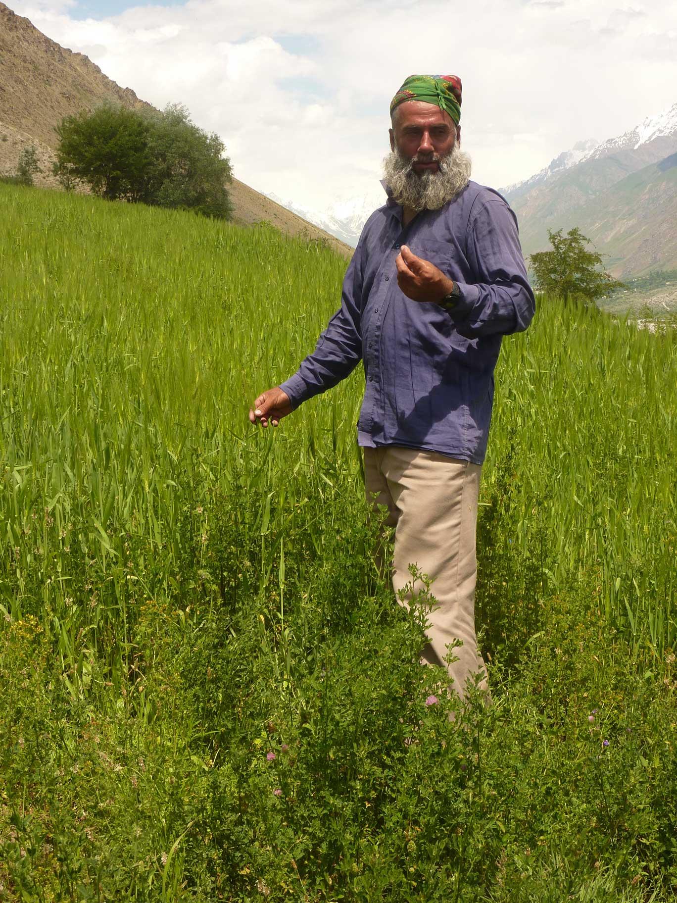
5.6 Characteristics of land users applying the Technology
Market orientation of production system:
- subsistence (self-supply)
- mixed (subsistence/ commercial)
Off-farm income:
- less than 10% of all income
Relative level of wealth:
- average
Individuals or groups:
- individual/ household
Level of mechanization:
- manual work
- animal traction
Gender:
- men
Indicate other relevant characteristics of the land users:
Land users applying the Technology are mainly common / average land users
Population density: 10-50 persons/km2
Annual population growth: 1% - 2%
5% of the land users are very rich.
10% of the land users are rich.
70% of the land users are average wealthy.
15% of the land users are poor.
10% of the land users are poor.
Off-farm income specification: The here described farmers family has very limited off-farm income. The farm provides sufficient fuel, fodder, fruits and potatoes for subsistence farming.
In general, seasonal migration to Russia is widespread in the area, which provides additional income in form of remittances. Only households with only young children, elderly and sick persons have no family member working in Russian.
Level of mechanization: One uses ochses for plowing, motorized is really rare.
5.7 Average area of land used by land users applying the Technology
- < 0.5 ha
- 0.5-1 ha
- 1-2 ha
- 2-5 ha
- 5-15 ha
- 15-50 ha
- 50-100 ha
- 100-500 ha
- 500-1,000 ha
- 1,000-10,000 ha
- > 10,000 ha
Is this considered small-, medium- or large-scale (referring to local context)?
- small-scale
5.8 Land ownership, land use rights, and water use rights
Land ownership:
- state
Land use rights:
- individual
Water use rights:
- individual
Comments:
The land use right for the individual farmer is documented with an official land user certificate.
Water use right has been agreed on with the village council.
5.9 Access to services and infrastructure
health:
- poor
- moderate
- good
education:
- poor
- moderate
- good
technical assistance:
- poor
- moderate
- good
employment (e.g. off-farm):
- poor
- moderate
- good
markets:
- poor
- moderate
- good
energy:
- poor
- moderate
- good
roads and transport:
- poor
- moderate
- good
drinking water and sanitation:
- poor
- moderate
- good
financial services:
- poor
- moderate
- good
6. Impacts and concluding statements
6.3 Exposure and sensitivity of the Technology to gradual climate change and climate-related extremes/ disasters (as perceived by land users)
Gradual climate change
Gradual climate change
| Season | increase or decrease | How does the Technology cope with it? | |
|---|---|---|---|
| annual temperature | increase | well |
Climate-related extremes (disasters)
Meteorological disasters
| How does the Technology cope with it? | |
|---|---|
| local rainstorm | not well |
| local windstorm | well |
Climatological disasters
| How does the Technology cope with it? | |
|---|---|
| drought | not well |
Hydrological disasters
| How does the Technology cope with it? | |
|---|---|
| general (river) flood | not well |
Other climate-related consequences
Other climate-related consequences
| How does the Technology cope with it? | |
|---|---|
| reduced growing period | well |
6.5 Adoption of the Technology
- single cases/ experimental
If available, quantify (no. of households and/ or area covered):
1 Household
Of all those who have adopted the Technology, how many did so spontaneously, i.e. without receiving any material incentives/ payments?
- 91-100%
7. References and links
7.1 Methods/ sources of information
Links and modules
Expand all Collapse allLinks
No links
Modules
No modules