Wetland rehabilitation [South Africa]
- Creation:
- Update:
- Compiler: Unknown User
- Editor: –
- Reviewers: David Streiff, Alexandra Gavilano
technologies_1377 - South Africa
View sections
Expand all Collapse all1. General information
1.2 Contact details of resource persons and institutions involved in the assessment and documentation of the Technology
Key resource person(s)
SLM specialist:
Bronkhorst Frik
Mpumalanga Parks Board
South Africa
Name of the institution(s) which facilitated the documentation/ evaluation of the Technology (if relevant)
Mpumalanga Tourism and Parks Authority Board (MTPA) - South Africa1.3 Conditions regarding the use of data documented through WOCAT
The compiler and key resource person(s) accept the conditions regarding the use of data documented through WOCAT:
Yes
1.5 Reference to Questionnaire(s) on SLM Approaches (documented using WOCAT)
Working for Water Wetland rehabilitation [South Africa]
To improve the quality & quantity of water production and biodiversity in the Blyde River catchment area.
- Compiler: Unknown User
2. Description of the SLM Technology
2.1 Short description of the Technology
Definition of the Technology:
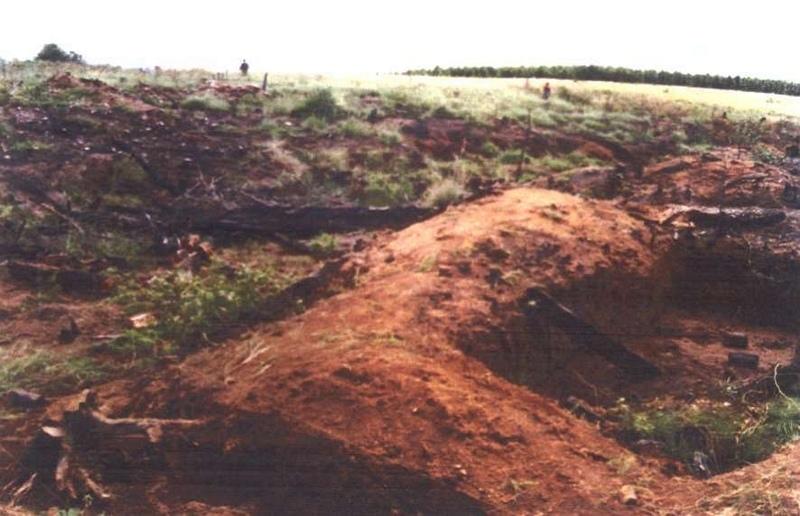
To rehabilitate/stabilise distorted wetlands as close as possible to its original state/function.
2.2 Detailed description of the Technology
Description:
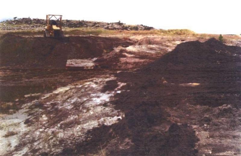
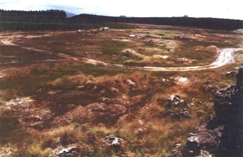
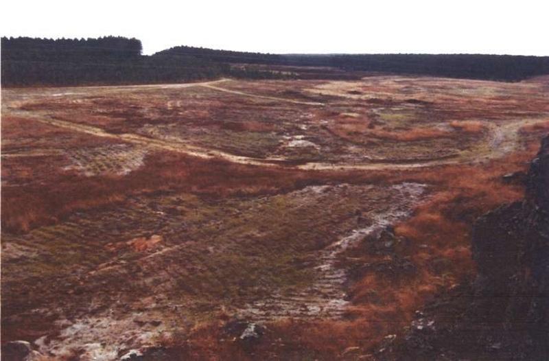
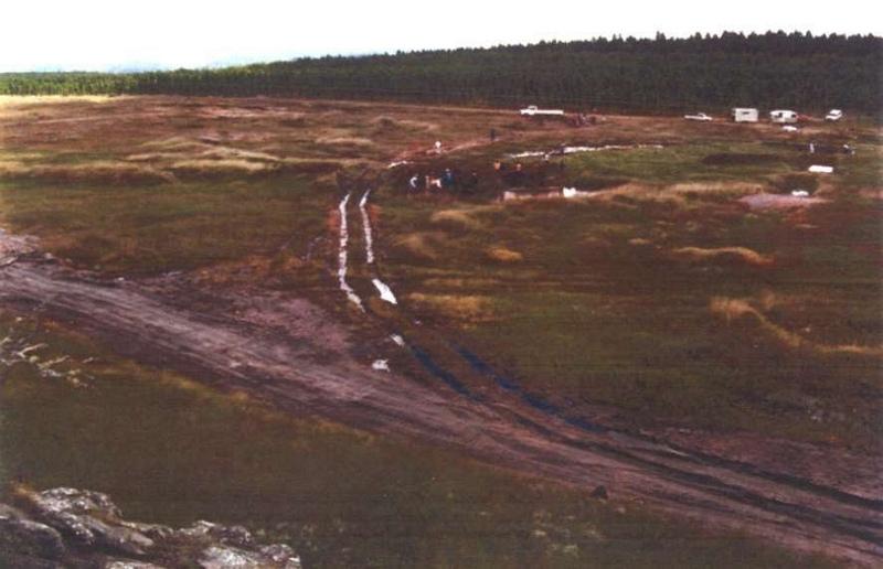
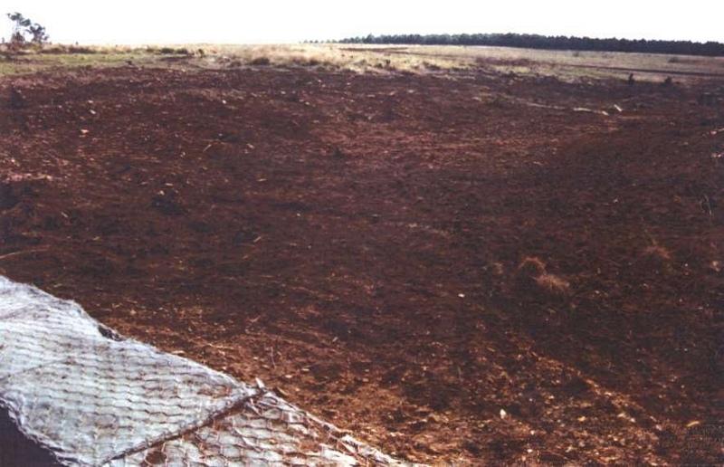
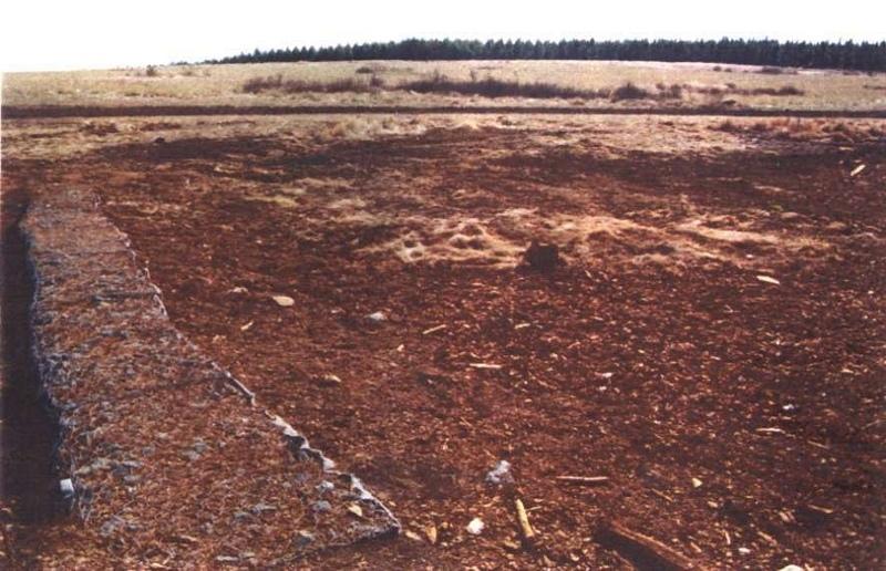
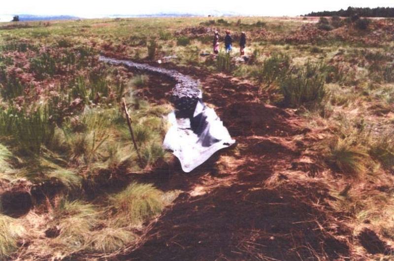
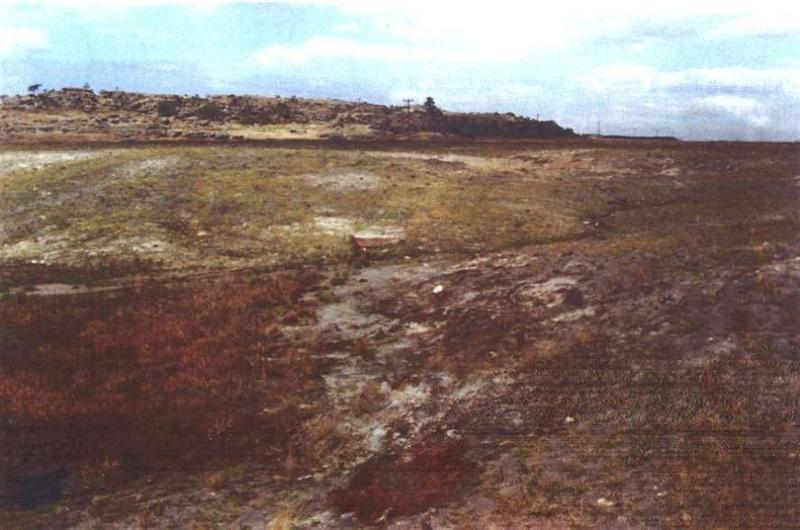
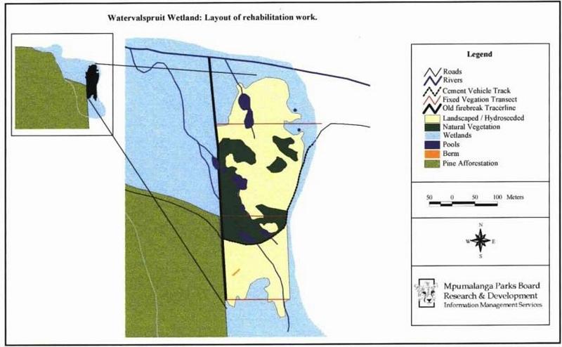
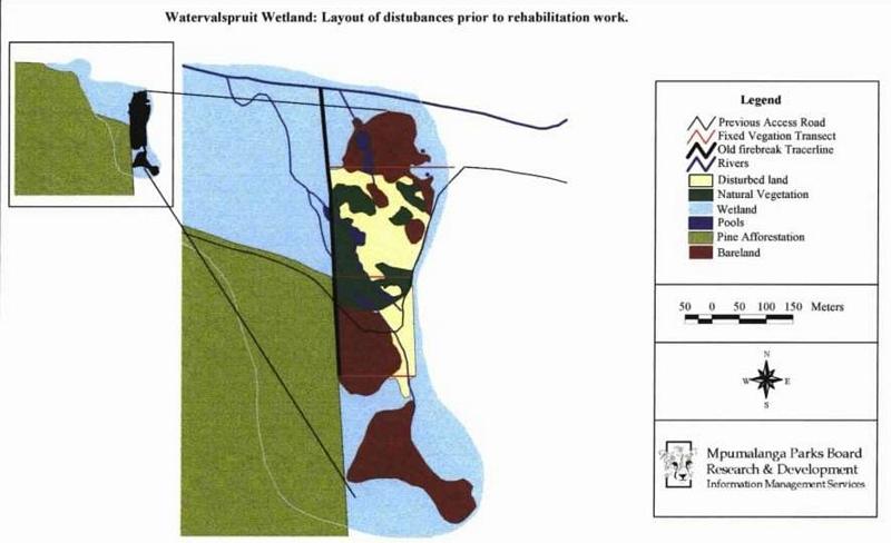
Two wetland rehabilitation sites that are part of a large wetland area (15 and 10ha).
Purpose of the Technology: The purpose of the rehabilitation work was to stabilise, landscape and re-vegetate distorted areas to again fulfil their original function in the catchment.
Establishment / maintenance activities and inputs: Maintenance included follow-up on re-seeding distorted areas and alien plant control (cut down plants and treads strips with roundup). Structure maintenance (such as gabions, roads) is also done.
Fire management to protect and manage the area of rehabilitation until such time as it has proved to be stabilised. Leave for ± 3 years before considering burning.
2.3 Photos of the Technology
Media Gallery
2.5 Country/ region/ locations where the Technology has been applied and which are covered by this assessment
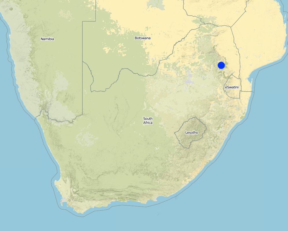
Country:
South Africa
Region/ State/ Province:
Mpumalanga
Further specification of location:
Mpumalanga
Specify the spread of the Technology:
- evenly spread over an area
If the Technology is evenly spread over an area, specify area covered (in km2):
0.3
If precise area is not known, indicate approximate area covered:
- 0.1-1 km2
Comments:
Total area covered by the SLM Technology is 0.3 km2.
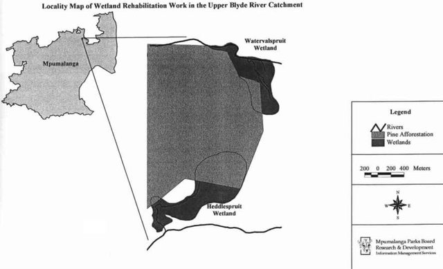
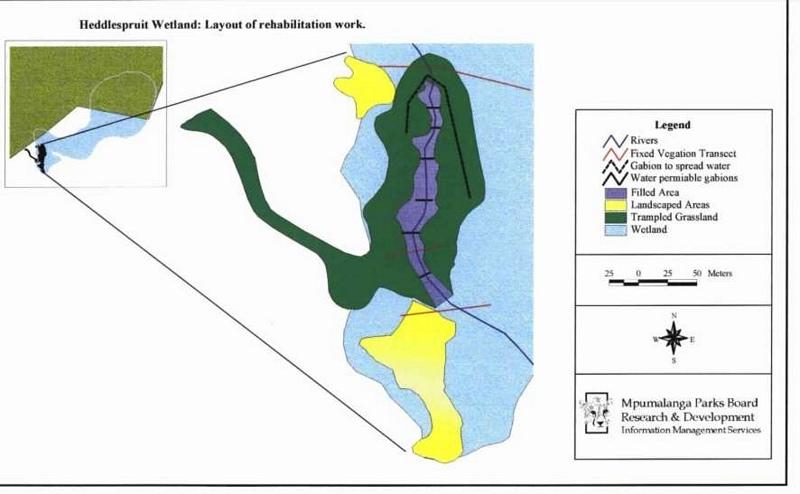
Wetland rehabilitation work has been executed on two wetlands in the upper catchment of the Blyde River in Mpumalanga.
Map
×2.6 Date of implementation
If precise year is not known, indicate approximate date:
- less than 10 years ago (recently)
2.7 Introduction of the Technology
Specify how the Technology was introduced:
- through projects/ external interventions
Comments (type of project, etc.):
Subjective inputs/discussions with specialists in variety of disciplines (scientist, botanists, hydrologists, managers, ecologists)
3. Classification of the SLM Technology
3.1 Main purpose(s) of the Technology
- conserve ecosystem
3.2 Current land use type(s) where the Technology is applied

Grazing land
Extensive grazing:
- Ranching
- game
Comments:
Major land use problems (compiler’s opinion): Afforestation: Pine plantations destroys diversity, also has a major effect on quality & quantity of water run-off, mining opencast activities
Major land use problems (land users’ perception): Production of wood/timber, job creation
Ranching: Game occur natural in this area/nature reserve
Grazingland comments: Area in which these two wetlands are situated is proclaimed conservation land. The aim is to manage the area in an as natural as possible condition as it was historically.
Type of grazing system comments: Area in which these two wetlands are situated is proclaimed conservation land. The aim is to manage the area in an as natural as possible condition as it was historically.
Constraints of nature reserve: Fire management/adjacent to pine plantations
Longest growing period in days: 240; Longest growing period from month to month: Oct - May
3.5 SLM group to which the Technology belongs
- area closure (stop use, support restoration)
- wetland protection/ management
3.6 SLM measures comprising the Technology

agronomic measures

vegetative measures

structural measures
Comments:
Main measures: vegetative measures, structural measures, management measures
3.7 Main types of land degradation addressed by the Technology

soil erosion by water
- Wt: loss of topsoil/ surface erosion

physical soil deterioration
- Pu: loss of bio-productive function due to other activities

water degradation
- Ha: aridification
Comments:
Main causes of degradation: industrial activities and mining, education, access to knowledge and support services (Mineral affairs don’t inspect and allows anything.), Lack of enforcement of legislat./authority (2.1.3.2 Government has not enough authority), Mining
Secondary causes of degradation: Forestry
3.8 Prevention, reduction, or restoration of land degradation
Specify the goal of the Technology with regard to land degradation:
- restore/ rehabilitate severely degraded land
4. Technical specifications, implementation activities, inputs, and costs
4.1 Technical drawing of the Technology
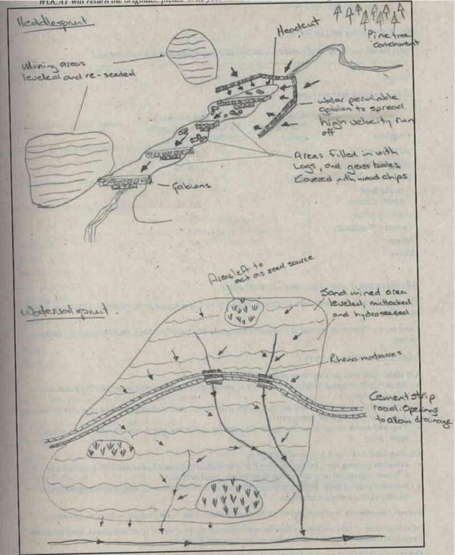
Technical specifications (related to technical drawing):
Wetland rehabilitation
Location: Blyde canyon. Mpumalanga
Technical knowledge required for field staff / advisors: high
Technical knowledge required for land users: moderate
Main technical functions: control of raindrop splash, control of dispersed runoff: retain / trap, control of concentrated runoff: retain / trap, improvement of ground cover, increase of infiltration, increase / maintain water stored in soil, control of fires, fire management
Secondary technical functions: control of concentrated runoff: drain / divert, reduction of slope length, increase of surface roughness, increase in organic matter, water spreading, increase in soil fertility
Vegetative measure: contour
Vegetative material: G : grass
Vertical interval between rows / strips / blocks (m): 0.1
Spacing between rows / strips / blocks (m): 0.5
Vegetative measure: graded strips
Vegetative material: G : grass
Vegetative measure: Vegetative material: G : grass
Grass species: Eragrostis, Stiburus, Cynodon
Gradient along the rows / strips: 3.00%
Diversion ditch/ drainage
Height of bunds/banks/others (m): 0.5
Width of bunds/banks/others (m): 0.5
Length of bunds/banks/others (m): 60
Structural measure: road
Depth of ditches/pits/dams (m): 0.15
Width of ditches/pits/dams (m): 0.5
Length of ditches/pits/dams (m): 120
Structural measure: filling heddle
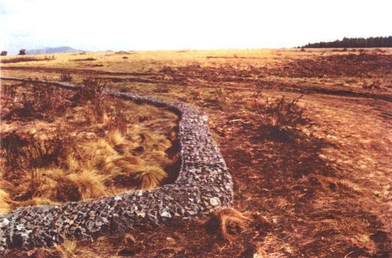
Structural measure: bunds/banks: contour
Vertical interval between structures (m): 0.15
Spacing between structures (m): 0.15
Construction material (earth): Contour muttrocking
Construction material (stone): At Heddlespruit: gabions & stonewall to spread high velocity runoff
Construction material (concrete): Strip road with 1m interval openings to allow for draining
Construction material (other): Heddle filling: pine logs, hay bales, wood chips
Vegetation is used for stabilisation of structures.
Other type of management: Fire management
Author:
Frik Bronkhorst
4.2 General information regarding the calculation of inputs and costs
other/ national currency (specify):
rand
If relevant, indicate exchange rate from USD to local currency (e.g. 1 USD = 79.9 Brazilian Real): 1 USD =:
8.0
Indicate average wage cost of hired labour per day:
4.00
4.3 Establishment activities
| Activity | Timing (season) | |
|---|---|---|
| 1. | Hydro-seeding | Directly after landscaping/levelling |
| 2. | Hand seeding | Directly after landscaping/levelling |
| 3. | Harvesting & replanting of vlei grass | Directly after landscaping/levelling |
| 4. | Scarifying forming | Directly after landscaping/levelling |
| 5. | Horizontal chills | Directly after landscaping/levelling |
| 6. | Gabion building | March |
| 7. | Landscaping | March |
| 8. | Muttrocking | April |
| 9. | Replanting grasses | April |
| 10. | Hydroseeding | April/May |
| 11. | Tracers and firebreaks (to secure rehabilitation work) | Autumn/winter |
4.4 Costs and inputs needed for establishment
| Specify input | Unit | Quantity | Costs per Unit | Total costs per input | % of costs borne by land users | |
|---|---|---|---|---|---|---|
| Labour | Rehabilitate wetland | ha | 1.0 | 56000.0 | 56000.0 | 80.0 |
| Total costs for establishment of the Technology | 56000.0 | |||||
| Total costs for establishment of the Technology in USD | 7000.0 | |||||
Comments:
Duration of establishment phase: 12 month(s)
4.5 Maintenance/ recurrent activities
| Activity | Timing/ frequency | |
|---|---|---|
| 1. | Fire protection | June /Once a year |
| 2. | Gabion maintenance | /Ad hoc |
| 3. | Hydroseeding | September/Once |
| 4. | Gabion maintenance | Ad hoc/Ad hoc |
| 5. | Road maintenance | Ad hoc/Ad hoc |
| 6. | Tracers & firebreaks | Autumn / Annual |
4.7 Most important factors affecting the costs
Describe the most determinate factors affecting the costs:
Labour: By using machinery where applicable, work can be done less expensive.
Weather conditions: High rainfall areas, delays work, can destroy half done/partially done processes.
5. Natural and human environment
5.1 Climate
Annual rainfall
- < 250 mm
- 251-500 mm
- 501-750 mm
- 751-1,000 mm
- 1,001-1,500 mm
- 1,501-2,000 mm
- 2,001-3,000 mm
- 3,001-4,000 mm
- > 4,000 mm
Specify average annual rainfall (if known), in mm:
2500.00
Agro-climatic zone
- humid
5.2 Topography
Slopes on average:
- flat (0-2%)
- gentle (3-5%)
- moderate (6-10%)
- rolling (11-15%)
- hilly (16-30%)
- steep (31-60%)
- very steep (>60%)
Landforms:
- plateau/plains
- ridges
- mountain slopes
- hill slopes
- footslopes
- valley floors
Altitudinal zone:
- 0-100 m a.s.l.
- 101-500 m a.s.l.
- 501-1,000 m a.s.l.
- 1,001-1,500 m a.s.l.
- 1,501-2,000 m a.s.l.
- 2,001-2,500 m a.s.l.
- 2,501-3,000 m a.s.l.
- 3,001-4,000 m a.s.l.
- > 4,000 m a.s.l.
5.3 Soils
Soil depth on average:
- very shallow (0-20 cm)
- shallow (21-50 cm)
- moderately deep (51-80 cm)
- deep (81-120 cm)
- very deep (> 120 cm)
Soil texture (topsoil):
- coarse/ light (sandy)
- fine/ heavy (clay)
Topsoil organic matter:
- medium (1-3%)
- low (<1%)
If available, attach full soil description or specify the available information, e.g. soil type, soil PH/ acidity, Cation Exchange Capacity, nitrogen, salinity etc.
Soil depth on average: Very shallow for Watervalspruit wetland and moderatly deep for Heddlespruit wetland
Soil texture: Coarse for Watervalspruit wetland and fine for Heddlespruit wetland
Topsoil organic matter: Medium for Heddlespruit wetland and low for Watervalspruit wetland
Soil fertility is high for Watervalspruit wetland and very low for Heddlespruit wetland
Soil drainage / infiltration is good for Watervalspruit wetland and medium for Heddlespruit wetland
Soil water storage capacity is very high for Heddlespruit wetland and medium for Watervalspruit wetland
5.6 Characteristics of land users applying the Technology
Relative level of wealth:
- very poor
Indicate other relevant characteristics of the land users:
(State budget limitations (Parks board)).
5.8 Land ownership, land use rights, and water use rights
Land ownership:
- state
- company
6. Impacts and concluding statements
6.1 On-site impacts the Technology has shown
Socio-economic impacts
Other socio-economic impacts
Employment
Comments/ specify:
Approx. 100 people for 4 month employed
Socio-cultural impacts
conflict mitigation
Ecological impacts
Water cycle/ runoff
water quantity
Comments/ specify:
Only during rainy seasons, prevent water
excess water drainage
Soil
soil moisture
soil cover
soil loss
Other ecological impacts
soil fertility
biodiversity
Conservation
Comments/ specify:
Distracted wetland areas on reserve rehabilitated
6.2 Off-site impacts the Technology has shown
reliable and stable stream flows in dry season
downstream flooding
downstream siltation
groundwater/ river pollution
6.5 Adoption of the Technology
Comments:
There is a moderate trend towards spontaneous adoption of the Technology
Comments on adoption trend: 3.4.2.4 Mpumalanga is the first. A proposal for the Lowveld has been submitted and also D. Lindley.
Moderate increase; next year there will be another wetland in the project.
6.7 Strengths/ advantages/ opportunities of the Technology
| Strengths/ advantages/ opportunities in the compiler’s or other key resource person’s view |
|---|
|
Hydroseeding How can they be sustained / enhanced? Provides quick basal cover to limit erosion |
|
Cement strip-road How can they be sustained / enhanced? Almost no maintenance necessary |
|
Stabilization of erosion How can they be sustained / enhanced? Gabions well build, minimal maintenance |
6.8 Weaknesses/ disadvantages/ risks of the Technology and ways of overcoming them
| Weaknesses/ disadvantages/ risks in the compiler’s or other key resource person’s view | How can they be overcome? |
|---|---|
| Landscaping of stabilized areas | Must be done to re-shape area - no solution |
| Access roads | Correct choice of season for construction phase |
7. References and links
7.1 Methods/ sources of information
7.2 References to available publications
Title, author, year, ISBN:
Business plan: Wetland rehabilitation, Blyde River Catchment
Available from where? Costs?
Mpumalanga Parks Board, P.O. Box 511, Graskop 1270,Lydenburg,South Africa
Links and modules
Expand all Collapse allLinks
Working for Water Wetland rehabilitation [South Africa]
To improve the quality & quantity of water production and biodiversity in the Blyde River catchment area.
- Compiler: Unknown User
Modules
No modules