Gabion check dam [Tunisia]
- Creation:
- Update:
- Compiler: Mongi Ben Zaied
- Editor: –
- Reviewers: Alexandra Gavilano, Fabian Ottiger
Ouvrage en gabion
technologies_1400 - Tunisia
View sections
Expand all Collapse all1. General information
1.2 Contact details of resource persons and institutions involved in the assessment and documentation of the Technology
Key resource person(s)
SLM specialist:
Mongi Sghaier
Institut des Régions Arides IRA
Tunisia
SLM specialist:
SLM specialist:
Chniter Mongi
Commissariats Régionaux au Développement Agricole CRDA
Tunisia
Name of the institution(s) which facilitated the documentation/ evaluation of the Technology (if relevant)
Institut des Régions Arides de Médenine (Institut des Régions Arides de Médenine) - TunisiaName of the institution(s) which facilitated the documentation/ evaluation of the Technology (if relevant)
Commissariats Régionaux au Développement Agricole (CRDA) - Tunisia1.3 Conditions regarding the use of data documented through WOCAT
The compiler and key resource person(s) accept the conditions regarding the use of data documented through WOCAT:
Yes
2. Description of the SLM Technology
2.1 Short description of the Technology
Definition of the Technology:
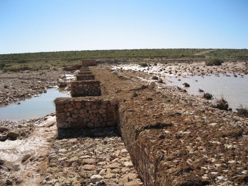
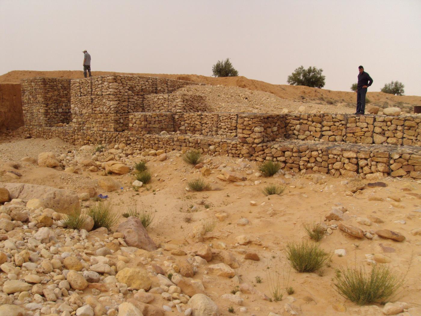
The technology of check dam is a technique consisting of binding different gabion cages filled with small stones together to form a complete flexible gabion unit.
2.2 Detailed description of the Technology
Description:
In order to slow down the water flow in the wadi courses and improve its infiltration into deeper soil layers and geologic formations, small check dams are installed on the wadi beds. They are usually positioned in series, with a spacing of 100-500m. These dams are made of gabion.
The gabion technique has been first introduced in the civil engineering domain. They are largely used since then and found many applications.
A gabion is a cage which has a cubic shape filled with stony material of suitable diameter enclosed in metal grating keeping the stones together and stops them from moving under the pressure of water. The gabion is normally the name of the cage only but it is also used frequently for the whole structure itself. The technique of gabion check dam consists in binding different cages together to form a complete gabion unit. The average height varies from 1 to 4 m and its length is a function of the width of the wadi bed (Royet, 1992).
2.3 Photos of the Technology
Media Gallery
2.5 Country/ region/ locations where the Technology has been applied and which are covered by this assessment
Country:
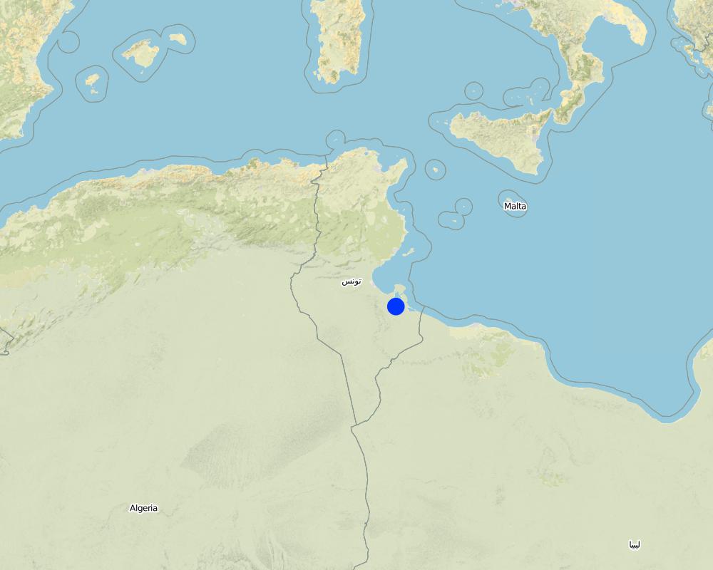
Tunisia
Region/ State/ Province:
Medenine
Further specification of location:
Beni Kedhache - Bhayra
Specify the spread of the Technology:
- evenly spread over an area
If precise area is not known, indicate approximate area covered:
- 10-100 km2
Comments:
This technique is practiced in the Jeffara plain as well as in the mountain region.
Map
×2.6 Date of implementation
If precise year is not known, indicate approximate date:
- 10-50 years ago
2.7 Introduction of the Technology
Specify how the Technology was introduced:
- through projects/ external interventions
Comments (type of project, etc.):
In the provinnce of Medenine, the first gabion check dams used for groudwater recharge and spreading have been constructed starting from 1985.
3. Classification of the SLM Technology
3.2 Current land use type(s) where the Technology is applied

Cropland
- Tree and shrub cropping
Number of growing seasons per year:
- 1
Specify:
Longest growing period in days: 180Longest growing period from month to month: Oct - Mar

Grazing land
- Extensive grazing land
Comments:
Major land use problems (compiler’s opinion): -Degradation of soil and land cover
-Loss of water and soil ressources
-Flooding
Major land use problems (land users’ perception): Loss of water resources by flow out from the watershed
Future (final) land use (after implementation of SLM Technology): Cropland: Ct: Tree and shrub cropping
Constraints of wadi beds: floods
3.3 Has land use changed due to the implementation of the Technology?
Has land use changed due to the implementation of the Technology?
- Yes (Please fill out the questions below with regard to the land use before implementation of the Technology)
Land use mixed within the same land unit:
Yes
Cropland
- Tree and shrub cropping
Grazing land
Comments:
Constraints of wadi beds: floods
3.5 SLM group to which the Technology belongs
- water harvesting
- irrigation management (incl. water supply, drainage)
3.6 SLM measures comprising the Technology

structural measures
- S5: Dams, pans, ponds
Comments:
Main measures: structural measures
3.7 Main types of land degradation addressed by the Technology

soil erosion by water
- Wt: loss of topsoil/ surface erosion
- Wg: gully erosion/ gullying
- Wr: riverbank erosion
- Wo: offsite degradation effects
Comments:
Main type of degradation addressed: Wg: gully erosion / gullying
Secondary types of degradation addressed: Wt: loss of topsoil / surface erosion, Wr: riverbank erosion, Wo: offsite degradation effects
Main causes of degradation: deforestation / removal of natural vegetation (incl. forest fires) (intensity)
Secondary causes of degradation: over-exploitation of vegetation for domestic use, overgrazing (degradation of land cover), Heavy / extreme rainfall (intensity/amounts)
3.8 Prevention, reduction, or restoration of land degradation
Specify the goal of the Technology with regard to land degradation:
- prevent land degradation
- restore/ rehabilitate severely degraded land
Comments:
Main goals: rehabilitation / reclamation of denuded land
Secondary goals: prevention of land degradation
Third goal: mitigation / reduction of land degradation
4. Technical specifications, implementation activities, inputs, and costs
4.1 Technical drawing of the Technology
Technical specifications (related to technical drawing):
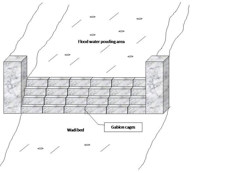
Gabion check dam is made of galvanised blocks filled with stones.
Location: Jeffara plain. Medenine, Tunisia
Date: January 2009
Technical knowledge required for field staff / advisors: high
Technical knowledge required for land users: moderate
Main technical functions: increase of groundwater level / recharge of groundwater
Secondary technical functions: increase of infiltration, increase / maintain water stored in soil, water harvesting / increase water supply, water spreading, sediment retention / trapping, sediment harvesting
Dam/ pan/ pond
Vertical interval between structures (m): 3-5
Spacing between structures (m): 100-500
Height of bunds/banks/others (m): 1-4
Width of bunds/banks/others (m): 4-6
Length of bunds/banks/others (m): 30-100
Construction material (stone): The average length varies between 15 and 30 cm
Construction material (other): Gabion: Galvanised cages of 1 to 3 m3.
Slope (which determines the spacing indicated above): 3-8%
Lateral gradient along the structure: <1%
Specification of dams/ pans/ ponds: Capacity 5000-15000m3
Catchment area: 1-3 ham2
Beneficial area: 30-100ham2
Other specifications: The whole structure has the form of a spillway.
Author:
Ouessar M., Medenine, Tunisia
4.2 General information regarding the calculation of inputs and costs
other/ national currency (specify):
Tunisian Dinars
If relevant, indicate exchange rate from USD to local currency (e.g. 1 USD = 79.9 Brazilian Real): 1 USD =:
1.3
Indicate average wage cost of hired labour per day:
10.00
4.3 Establishment activities
| Activity | Timing (season) | |
|---|---|---|
| 1. | Topographic survey and selection of the site | |
| 2. | Digging of the basement | |
| 3. | Gabion installation |
4.4 Costs and inputs needed for establishment
| Specify input | Unit | Quantity | Costs per Unit | Total costs per input | % of costs borne by land users | |
|---|---|---|---|---|---|---|
| Labour | Labour | Dam | 1.0 | 5000.0 | 5000.0 | 100.0 |
| Construction material | Construction material | dam | 1.0 | 5000.0 | 5000.0 | 100.0 |
| Construction material | Gabion cages | dam | 1.0 | 10000.0 | 10000.0 | 100.0 |
| Total costs for establishment of the Technology | 20000.0 | |||||
| Total costs for establishment of the Technology in USD | 15384.62 | |||||
Comments:
Duration of establishment phase: 1.5 month(s)
4.5 Maintenance/ recurrent activities
| Activity | Timing/ frequency | |
|---|---|---|
| 1. | Repair of breaks | each 1 to 2 years |
| 2. | Reconstruction | After heavy floods (once in 5-10 years) |
4.6 Costs and inputs needed for maintenance/ recurrent activities (per year)
| Specify input | Unit | Quantity | Costs per Unit | Total costs per input | % of costs borne by land users | |
|---|---|---|---|---|---|---|
| Labour | Labour | dam | 1.0 | 500.0 | 500.0 | 100.0 |
| Construction material | construction material | dam | 1.0 | 500.0 | 500.0 | 100.0 |
| Construction material | Gabion cages | dam | 1.0 | 1000.0 | 1000.0 | 100.0 |
| Total costs for maintenance of the Technology | 2000.0 | |||||
| Total costs for maintenance of the Technology in USD | 1538.46 | |||||
Comments:
Machinery/ tools: Generally, the work is manual but tractors can be used too.
4.7 Most important factors affecting the costs
Describe the most determinate factors affecting the costs:
construction materials
5. Natural and human environment
5.1 Climate
Annual rainfall
- < 250 mm
- 251-500 mm
- 501-750 mm
- 751-1,000 mm
- 1,001-1,500 mm
- 1,501-2,000 mm
- 2,001-3,000 mm
- 3,001-4,000 mm
- > 4,000 mm
Specifications/ comments on rainfall:
Dry period from April to September
Agro-climatic zone
- arid
Thermal climate class: subtropics
5.2 Topography
Slopes on average:
- flat (0-2%)
- gentle (3-5%)
- moderate (6-10%)
- rolling (11-15%)
- hilly (16-30%)
- steep (31-60%)
- very steep (>60%)
Landforms:
- plateau/plains
- ridges
- mountain slopes
- hill slopes
- footslopes
- valley floors
Altitudinal zone:
- 0-100 m a.s.l.
- 101-500 m a.s.l.
- 501-1,000 m a.s.l.
- 1,001-1,500 m a.s.l.
- 1,501-2,000 m a.s.l.
- 2,001-2,500 m a.s.l.
- 2,501-3,000 m a.s.l.
- 3,001-4,000 m a.s.l.
- > 4,000 m a.s.l.
5.4 Water availability and quality
Ground water table:
5-50 m
Water quality (untreated):
poor drinking water (treatment required)
Comments and further specifications on water quality and quantity:
Availability of surface water: excess, medium, poor/ none (The wadi is almost always dry)
Water quality (untreated): Poor drinking water (treatement required) (from cisterns and wells) but good drinking water if pumped in the deep aquifer (100-300m)
5.5 Biodiversity
Species diversity:
- medium
5.6 Characteristics of land users applying the Technology
Off-farm income:
- > 50% of all income
Relative level of wealth:
- average
- rich
Individuals or groups:
- groups/ community
Gender:
- men
Indicate other relevant characteristics of the land users:
Land users applying the Technology are mainly common / average land users
Difference in the involvement of women and men: Historically, the hard work is done by men.
Population density: 10-50 persons/km2
Annual population growth: < 0.5%
30% of the land users are rich and own 50% of the land.
60% of the land users are average wealthy and own 30% of the land.
10% of the land users are poor and own 20% of the land.
Off-farm income specification: Off-farm incomes come from migration, construction works, commerce, tourism sector, administration or informal activities.
5.7 Average area of land used by land users applying the Technology
- < 0.5 ha
- 0.5-1 ha
- 1-2 ha
- 2-5 ha
- 5-15 ha
- 15-50 ha
- 50-100 ha
- 100-500 ha
- 500-1,000 ha
- 1,000-10,000 ha
- > 10,000 ha
Is this considered small-, medium- or large-scale (referring to local context)?
- small-scale
5.8 Land ownership, land use rights, and water use rights
Land ownership:
- state
Land use rights:
- communal (organized)
Water use rights:
- communal (organized)
Comments:
Generally, this technology is applied in the wadi beds which is considered as state owned but the local community can have access.
5.9 Access to services and infrastructure
health:
- poor
- moderate
- good
education:
- poor
- moderate
- good
technical assistance:
- poor
- moderate
- good
employment (e.g. off-farm):
- poor
- moderate
- good
markets:
- poor
- moderate
- good
energy:
- poor
- moderate
- good
roads and transport:
- poor
- moderate
- good
drinking water and sanitation:
- poor
- moderate
- good
financial services:
- poor
- moderate
- good
6. Impacts and concluding statements
6.1 On-site impacts the Technology has shown
Socio-economic impacts
Production
crop production
fodder production
Socio-cultural impacts
Improved livelihoods and human well-being
Comments/ specify:
Recharge of groundwater (water less salty and more available) and protection against the floods.
Ecological impacts
Water cycle/ runoff
water quantity
water quality
surface runoff
groundwater table/ aquifer
Soil
soil loss
6.2 Off-site impacts the Technology has shown
water availability
downstream flooding
downstream siltation
6.3 Exposure and sensitivity of the Technology to gradual climate change and climate-related extremes/ disasters (as perceived by land users)
Climate-related extremes (disasters)
Meteorological disasters
| How does the Technology cope with it? | |
|---|---|
| local rainstorm | well |
Hydrological disasters
| How does the Technology cope with it? | |
|---|---|
| general (river) flood | well |
6.4 Cost-benefit analysis
How do the benefits compare with the establishment costs (from land users’ perspective)?
Short-term returns:
slightly negative
Long-term returns:
positive
How do the benefits compare with the maintenance/ recurrent costs (from land users' perspective)?
Short-term returns:
positive
Long-term returns:
positive
Comments:
Gabion chech dams are financed by the State
6.5 Adoption of the Technology
Comments:
Comments on acceptance with external material support: This technology is supposed to be implemented solely by the government agencicies but in some cases the farmers can make use of it.
Comments on spontaneous adoption: This technology is supposed to be implemented solely by the government agencicies but in some cases the farmers can make use of it.
6.7 Strengths/ advantages/ opportunities of the Technology
| Strengths/ advantages/ opportunities in the land user’s view |
|---|
|
Efficient structures How can they be sustained / enhanced? Regular and good maintenance |
| Strengths/ advantages/ opportunities in the compiler’s or other key resource person’s view |
|---|
|
Robust and flexible structures How can they be sustained / enhanced? Regular and good maintenance |
6.8 Weaknesses/ disadvantages/ risks of the Technology and ways of overcoming them
| Weaknesses/ disadvantages/ risks in the land user’s view | How can they be overcome? |
|---|---|
| They can not be fully exploited by the farmers | Change regulations. |
| Very expensive and cost not affordable by normal farmers | Continue subsidising by the government. |
| Weaknesses/ disadvantages/ risks in the compiler’s or other key resource person’s view | How can they be overcome? |
|---|---|
| Accumulation of sediments | Desilting |
7. References and links
7.1 Methods/ sources of information
7.2 References to available publications
Title, author, year, ISBN:
Yahyaoui, H., Chaieb, H., Ouessar, M. 2002. Impact des travaux de conservation des eaux et des sols sur la recharge de la nappe de Zeuss-Koutine (Sud-est tunisien). TRMP paper n° 40, Wageningen University, The Netherlands, pp: 71-86.
Available from where? Costs?
IRA - Medenine; DGRE - Tunis
Title, author, year, ISBN:
Boufelgha et al. 1998. Comportement des ouvrages CES dans le bassin versant d’oued Koutine lors de la crue d'Octobre 1998. Rapport interne, CRDA, Médenine
Available from where? Costs?
CRDA Médenine
Title, author, year, ISBN:
Chniter et al. 2007. Comportement des ouvrages CES dans le bassin versant d’oued Oum Zessar lors de la crue de 22 Février 2007. Rapport interne, CRDA, Médenine
Available from where? Costs?
CRDA Médenine
Title, author, year, ISBN:
Sghaier, M., Mahdhi, N., De Graaff, J., Ouessar, M. 2002. Economic assessment of soil and water conservation works: case of the wadi Oum Zessar watershed in south-eastern Tunisia.TRMP paper n° 40, Wageningen University, The Netherlands, pp: 101-113.
Available from where? Costs?
IRA
Title, author, year, ISBN:
Mahdhi, N., Sghaier, M, Ouessar, M. 2000. Analyse d’impacts des aménagements de CES en zone aride: cas du bassin versant d’Oued Oum Zessar. Technical report, WAHIA project, IRA, Tunisia.
Available from where? Costs?
IRA
Title, author, year, ISBN:
Yahyaoui, H., Ouessar, M. 2000. Abstraction and recharge impacts on the ground water in the arid regions of Tunisia: Case of Zeuss-Koutine water table. UNU Desertification Series, 2: 72-78.
Available from where? Costs?
IRA
Title, author, year, ISBN:
Ouessar M. 2007. Hydrological impacts of rainwater harvesting in wadi Oum Zessar watershed (Southern Tunisia). Ph.D. thesis, Faculty of Bioscience Engineering, Ghent University, Ghent, Belgium, 154 pp.
Available from where? Costs?
IRA - Médenine;
Links and modules
Expand all Collapse allLinks
No links
Modules
No modules