Water-spreading weirs [Mali]
- Creation:
- Update:
- Compiler: Dieter Nill
- Editor: –
- Reviewers: Deborah Niggli, Alexandra Gavilano
Seuils d’épandage (French)
technologies_1622 - Mali
View sections
Expand all Collapse all1. General information
1.2 Contact details of resource persons and institutions involved in the assessment and documentation of the Technology
SLM specialist:
Abdou Sani Mamadou
Programme d’Appui à l’agriculture Productive (PROMAP), Niamey, Niger
Niger
Name of project which facilitated the documentation/ evaluation of the Technology (if relevant)
Good Practices in Soil and Water Conservation - A contribution to adaptation and farmers ́ resilience towards climate change in the Sahel (GIZ)Name of the institution(s) which facilitated the documentation/ evaluation of the Technology (if relevant)
Deutsche Gesellschaft für Internationale Zusammenarbeit (GIZ) - Germany1.3 Conditions regarding the use of data documented through WOCAT
The compiler and key resource person(s) accept the conditions regarding the use of data documented through WOCAT:
Yes
1.4 Declaration on sustainability of the described Technology
Is the Technology described here problematic with regard to land degradation, so that it cannot be declared a sustainable land management technology?
No
2. Description of the SLM Technology
2.1 Short description of the Technology
Definition of the Technology:
Water-spreading weirs slow the flow of water, spread it over a wider area, increase infiltration and reduce erosion.
2.2 Detailed description of the Technology
Description:
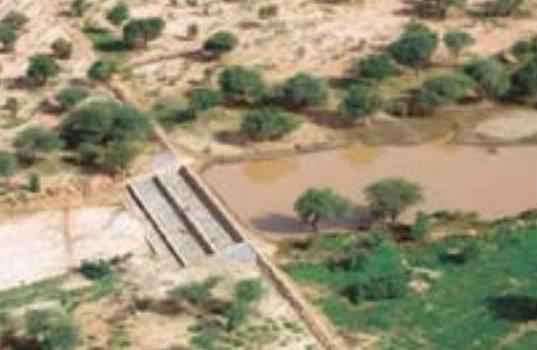
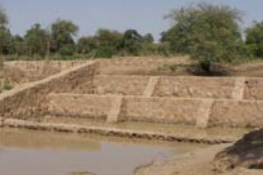
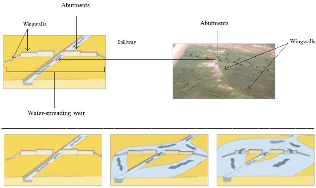
The water-spreading weir technique was developed in Burkina Faso, Niger and Chad in the late 1990s and early 2000s. They are suitable as a land improvement measure for 90% of valleys in the Sahel area. These weirs regulate floodwater in medium-sized watercourses and in wider degraded valley bottoms with a pronounced low-water channel. They are constructed with local materials and have a spillway in the middle, abutments on either side and long wingwalls to spread the water over a large area.
In order to reverse the degradation process in a valley, it is necessary to ensure the comprehensive rehabilitation of the degraded parts of the valley. This is why the technique requires an overall assessment of the valley in order to identify the causes of degradation. In order to restore the water system in a degraded valley, a series of weirs is generally required.
Water-spreading weirs slow the flow of water in valleys and spread it over a wider area where it can infiltrate into the soil. In this way, they control river floodwater, and this reduces erosion and the loss of water. At the same time, sediments improve soil fertility and replenish the water table. When water flow is low in the valley, all the water passes over the spillway. When floodwater flow is stronger, the water is channelled towards the sides and flows over the outer lower wingwalls. When the floodwaters are at their heaviest, the water flows over even the higher walls. Downstream, the waters rejoin the low-water channel. Water-spreading weirs permit the reclamation and rehabilitation of degraded land and the restoration of vegetation cover. Thanks to the weirs, water flowing through the valleys can be used for crop growing, livestock raising and forestry.
Thanks to the infiltration of considerable amounts of water, water-spreading weirs contribute to raising the water table by several metres and improving ecological conditions in adjacent areas. As a result, vegetation cover is restored, which has a positive effect on biodiversity. By 2010, German cooperation had established water-spreading weirs in Niger to improve 10,000 hectares of land in valleys. Sorghum yields increased by between 50% and 100% per ha, from 400 kg to 800 kg per ha. The production of sorghum was 10 to 15 times higher in the improved areas than it had been before. As water-spreading weirs raise the water table, areas can be developed (or abandoned farmland restored) for market gardening and horticulture, with two or three crop harvests a year. The produce is used to supplement the food available and can also be sold (especially market garden produce).
The amount of time spent by women and girls fetching water is reduced by several hours a day. Horticulture generates extra income to cover family expenses, such as education and health care. Growing crops outside the rainy season generates work all year round, which reduces temporary migration.
This technique requires accurate preliminary studies to design the system. The more degraded the valley, the more complex the work is. Improving severely degraded valleys requires extensive experience, and any necessary technical adjustments must be made when flaws are detected.
If the weirs are built to a high standard, with a certain amount of upkeep, they will last. Major repairs are beyond the means of the communities, which is why commune authorities are often assigned the role of project owner. However, this is not yet a satisfactory solution, as in most countries in the Sahel, commune authorities are still weak.
This technique has great potential for climate change adaptation in two scenarios: 1) Water-spreading weirs distribute the watershed’s water over wide areas of land in the valley bottom. This enables water resources to be used more efficiently in low-rainfall periods, during dry spells and when the rainy season ends early. 2) In high-rainfall periods and/or in the event of heavy downpours, water-spreading weirs slow the flow of water, thereby preventing or reducing gully and river bank erosion and protecting areas downstream.
2.3 Photos of the Technology
Media Gallery
2.5 Country/ region/ locations where the Technology has been applied and which are covered by this assessment
Country:
Mali
Region/ State/ Province:
Mali, Niger, Burkina Faso, Chad, Ethiopia
Comments:
By 2010, German cooperation had established water-spreading weirs in Niger to improve 10,000 hectares of land in valleys
2.6 Date of implementation
If precise year is not known, indicate approximate date:
- 10-50 years ago
2.7 Introduction of the Technology
Specify how the Technology was introduced:
- through projects/ external interventions
Comments (type of project, etc.):
The water-spreading weir technique was developed in Burkina Faso, Niger and Chad in the late 1990s and early 2000s.
By 2010, German cooperation had established water-spreading weirs in Niger to improve 10,000 hectares of land in valleys.
3. Classification of the SLM Technology
3.1 Main purpose(s) of the Technology
- reduce, prevent, restore land degradation
3.2 Current land use type(s) where the Technology is applied

Cropland
- Annual cropping
Number of growing seasons per year:
- 1
Specify:
Longest growing period in days: 120, Longest growing period from month to month: August to October

Waterways, waterbodies, wetlands
- Ponds, dams
Comments:
Major land use problems (compiler’s opinion): soil erosion by water and wind erosion, surface runoff, lack of infiltration, fertility decline
Constraints of common grazing land
Constraints of forested government-owned land or commons
3.4 Water supply
Water supply for the land on which the Technology is applied:
- mixed rainfed-irrigated
3.5 SLM group to which the Technology belongs
- irrigation management (incl. water supply, drainage)
- water diversion and drainage
- surface water management (spring, river, lakes, sea)
3.6 SLM measures comprising the Technology

structural measures
- S11: Others
Comments:
Specification of other structural measures: water-spreading weirs
3.7 Main types of land degradation addressed by the Technology

soil erosion by water
- Wt: loss of topsoil/ surface erosion

soil erosion by wind
- Et: loss of topsoil

chemical soil deterioration
- Cn: fertility decline and reduced organic matter content (not caused by erosion)

biological degradation
- Bc: reduction of vegetation cover

water degradation
- Ha: aridification
- Hg: change in groundwater/aquifer level
Comments:
Main causes of degradation: crop management (annual, perennial, tree/shrub) (Unadapted landuse methods, reduced or abandoned fallow periods), floods, droughts, population pressure (rapidly growing population increasing pressure on land), land tenure (insecure access to land)
3.8 Prevention, reduction, or restoration of land degradation
Specify the goal of the Technology with regard to land degradation:
- restore/ rehabilitate severely degraded land
4. Technical specifications, implementation activities, inputs, and costs
4.1 Technical drawing of the Technology
Technical specifications (related to technical drawing):
Water-spreading weirs are constructed with local materials and have a spillway in the middle, abutments on either side and long wingwalls to spread the water over a large area.
Technical knowledge required for field staff / advisors: high
Technical knowledge required for land users: low
Main technical functions: control of dispersed runoff: impede / retard, control of concentrated runoff: impede / retard, control of concentrated runoff: drain / divert, increase of infiltration, increase / maintain water stored in soil, increase of groundwater level / recharge of groundwater, water harvesting / increase water supply, water spreading
Secondary technical functions: improvement of ground cover
Dam/ pan/ pond
Depth of ditches/pits/dams (m): 1
Length of ditches/pits/dams (m): 50-100
Author:
Bender (2011)
4.2 General information regarding the calculation of inputs and costs
other/ national currency (specify):
CFA Franc
If relevant, indicate exchange rate from USD to local currency (e.g. 1 USD = 79.9 Brazilian Real): 1 USD =:
517.0
4.3 Establishment activities
| Activity | Timing (season) | |
|---|---|---|
| 1. | accurate preliminary studies to design the system | |
| 2. | transport of stones | |
| 3. | construction of water-spreading weir |
4.4 Costs and inputs needed for establishment
| Specify input | Unit | Quantity | Costs per Unit | Total costs per input | % of costs borne by land users | |
|---|---|---|---|---|---|---|
| Other | total construction | ha | 1.0 | 2901.0 | 2901.0 | 100.0 |
| Total costs for establishment of the Technology | 2901.0 | |||||
| Total costs for establishment of the Technology in USD | 5.61 | |||||
4.5 Maintenance/ recurrent activities
| Activity | Timing/ frequency | |
|---|---|---|
| 1. | upstream watershed development to prevent sand filling of the bottomlands | |
| 2. | any necessary technical adjustments must be made when flaws are detected |
4.7 Most important factors affecting the costs
Describe the most determinate factors affecting the costs:
The cost of improving land with water-spreading weirs is 0.25 to 1.5 million CFA francs per hectare (2901 US Dollar per ha). Labour:
• team formed by 25 people for 2 to 3 months, depending on the size of the structure.
Lorries to transport stones:
• 150 to 200 lorryloads (skip loader – 4.5 m3 per load) at a rate of 10 to 15 lorryloads a day.
Cost of construction:
• 1 medium-sized weir 50 m long and 1 m high with 200 m long wingwalls plus basin: 15 million CFA francs
• 1 weir 100 m long and 1 m high with basin: 30 to 32 million CFA francs
• stonework: 25,000 CFA francs/m3
• basin: 15,000 CFA francs/m3.
5. Natural and human environment
5.1 Climate
Annual rainfall
- < 250 mm
- 251-500 mm
- 501-750 mm
- 751-1,000 mm
- 1,001-1,500 mm
- 1,501-2,000 mm
- 2,001-3,000 mm
- 3,001-4,000 mm
- > 4,000 mm
Agro-climatic zone
- semi-arid
Thermal climate class: subtropics
5.2 Topography
Slopes on average:
- flat (0-2%)
- gentle (3-5%)
- moderate (6-10%)
- rolling (11-15%)
- hilly (16-30%)
- steep (31-60%)
- very steep (>60%)
Landforms:
- plateau/plains
- ridges
- mountain slopes
- hill slopes
- footslopes
- valley floors
Altitudinal zone:
- 0-100 m a.s.l.
- 101-500 m a.s.l.
- 501-1,000 m a.s.l.
- 1,001-1,500 m a.s.l.
- 1,501-2,000 m a.s.l.
- 2,001-2,500 m a.s.l.
- 2,501-3,000 m a.s.l.
- 3,001-4,000 m a.s.l.
- > 4,000 m a.s.l.
5.3 Soils
Soil depth on average:
- very shallow (0-20 cm)
- shallow (21-50 cm)
- moderately deep (51-80 cm)
- deep (81-120 cm)
- very deep (> 120 cm)
Soil texture (topsoil):
- medium (loamy, silty)
- fine/ heavy (clay)
5.4 Water availability and quality
Ground water table:
5-50 m
Availability of surface water:
medium
5.5 Biodiversity
Species diversity:
- low
5.6 Characteristics of land users applying the Technology
Relative level of wealth:
- very poor
- poor
Level of mechanization:
- manual work
- animal traction
Gender:
- men
Indicate other relevant characteristics of the land users:
Population density: 10-50 persons/km2
Annual population growth: 3% - 4% (mostly poor households below poverty line).
Off-farm income specification: men migrate temporarily or permanently to cities for off-farm income
Growing crops outside the rainy season generates work all year round, which reduces temporary migration.
5.7 Average area of land used by land users applying the Technology
- < 0.5 ha
- 0.5-1 ha
- 1-2 ha
- 2-5 ha
- 5-15 ha
- 15-50 ha
- 50-100 ha
- 100-500 ha
- 500-1,000 ha
- 1,000-10,000 ha
- > 10,000 ha
Is this considered small-, medium- or large-scale (referring to local context)?
- small-scale
5.8 Land ownership, land use rights, and water use rights
Land ownership:
- state
Land use rights:
- communal (organized)
Water use rights:
- communal (organized)
Comments:
traditional land use rights on fields, communal land on pasture and forest land
5.9 Access to services and infrastructure
health:
- poor
- moderate
- good
education:
- poor
- moderate
- good
technical assistance:
- poor
- moderate
- good
employment (e.g. off-farm):
- poor
- moderate
- good
markets:
- poor
- moderate
- good
energy:
- poor
- moderate
- good
roads and transport:
- poor
- moderate
- good
drinking water and sanitation:
- poor
- moderate
- good
financial services:
- poor
- moderate
- good
6. Impacts and concluding statements
6.1 On-site impacts the Technology has shown
Socio-economic impacts
Production
crop production
fodder production
risk of production failure
production area
Water availability and quality
demand for irrigation water
Socio-cultural impacts
food security/ self-sufficiency
conflict mitigation
contribution to human well-being
Comments/ specify:
Thanks to the weirs, water flowing through the valleys can be used for crop growing, livestock raising and forestry. The amount of time spent by women and girls fetching water is reduced by several hours a day. Horticulture generates extra income to cover family expenses, such as education and health care. Growing crops outside the rainy season generates work all year round, which reduces temporary migration.
Ecological impacts
Water cycle/ runoff
harvesting/ collection of water
surface runoff
excess water drainage
groundwater table/ aquifer
Soil
soil moisture
soil loss
nutrient cycling/ recharge
Other ecological impacts
sand filling siltation
6.2 Off-site impacts the Technology has shown
downstream flooding
downstream siltation
6.3 Exposure and sensitivity of the Technology to gradual climate change and climate-related extremes/ disasters (as perceived by land users)
Gradual climate change
Gradual climate change
| Season | increase or decrease | How does the Technology cope with it? | |
|---|---|---|---|
| annual temperature | increase | well |
Climate-related extremes (disasters)
Meteorological disasters
| How does the Technology cope with it? | |
|---|---|
| local rainstorm | well |
| local windstorm | well |
Climatological disasters
| How does the Technology cope with it? | |
|---|---|
| drought | well |
Hydrological disasters
| How does the Technology cope with it? | |
|---|---|
| general (river) flood | well |
Other climate-related consequences
Other climate-related consequences
| How does the Technology cope with it? | |
|---|---|
| reduced growing period | well |
6.4 Cost-benefit analysis
How do the benefits compare with the establishment costs (from land users’ perspective)?
Short-term returns:
positive
Long-term returns:
very positive
How do the benefits compare with the maintenance/ recurrent costs (from land users' perspective)?
Short-term returns:
positive
Long-term returns:
very positive
6.5 Adoption of the Technology
Comments:
There is a little trend towards spontaneous adoption of the Technology
In most countries in the Sahel, commune authorities are still weak. Without external support, the potential for replication is very low.
6.7 Strengths/ advantages/ opportunities of the Technology
| Strengths/ advantages/ opportunities in the land user’s view |
|---|
| Growing crops outside the rainy season generates work all year round, which reduces temporary migration. |
| The amount of time spent by women and girls fetching water is reduced by several hours a day |
| If the weirs are built to a high standard, with a certain amount of upkeep, they will last |
| Strengths/ advantages/ opportunities in the compiler’s or other key resource person’s view |
|---|
| Water-spreading weirs permit the reclamation and rehabilitation of degraded land and the restoration of vegetation cover. Suitable as a land improvement measure for 90% of valleys in the Sahel area. |
| Slow the flow of water in valleys and spread it over a wider area where it can infiltrate into the soil. The control of river floodwater reduces erosion and the loss of water. |
| sediments improve soil fertility and replenish the water table, vegetation cover is restored |
| As water-spreading weirs raise the water table, areas can be developed (or abandoned farmland restored) for market gardening and horticulture, with two or three crop harvests a year. The produce is used to supplement the food available and can also be sold (especially market garden produce). |
| Horticulture generates extra income to cover family expenses, such as education and health care. |
6.8 Weaknesses/ disadvantages/ risks of the Technology and ways of overcoming them
| Weaknesses/ disadvantages/ risks in the compiler’s or other key resource person’s view | How can they be overcome? |
|---|---|
| The evaluation carried out by the FICOD (investment fund for local authorities) in 2010 highlighted the serious problem of sand filling siltation in valleys when additional measures are not implemented in a watershed’s upstream areas to ensure the overall development of the whole watershed area. | To ensure that the effectiveness of water-spreading weirs is long-lasting, upstream watershed development is essential to prevent sand filling of the bottomlands. |
| Major repairs are beyond the means of the communities, which is why commune authorities are often assigned the role of project owner. However, this is not yet a satisfactory solution, as in most countries in the Sahel, commune authorities are still weak. |
7. References and links
7.1 Methods/ sources of information
- field visits, field surveys
- interviews with land users
When were the data compiled (in the field)?
01/07/2012
7.2 References to available publications
Title, author, year, ISBN:
Good Practices in Soil and Water Conservation. A contribution to adaptation and farmers´ resilience towards climate change in the Sahel. Published by GIZ in 2012.
Available from where? Costs?
http://agriwaterpedia.info/wiki/Main_Page
Links and modules
Expand all Collapse allLinks
No links
Modules
No modules