Dams with water-spreading weirs [Mali]
- Creation:
- Update:
- Compiler: Dieter Nill
- Editor: –
- Reviewers: Deborah Niggli, Alexandra Gavilano
Barrages avec seuils d’épandage déversant (French)
technologies_1633 - Mali
View sections
Expand all Collapse all1. General information
1.2 Contact details of resource persons and institutions involved in the assessment and documentation of the Technology
SLM specialist:
Dembele Celestin
HELVETAS Swiss Intercooperation
Mali
SLM specialist:
Doumbia Moussa
ADEPE MALI
Mali
Name of project which facilitated the documentation/ evaluation of the Technology (if relevant)
Manual of Good Practices in Small Scale Irrigation in the Sahel (GIZ )Name of the institution(s) which facilitated the documentation/ evaluation of the Technology (if relevant)
Deutsche Gesellschaft für Internationale Zusammenarbeit (GIZ) - Germany1.3 Conditions regarding the use of data documented through WOCAT
The compiler and key resource person(s) accept the conditions regarding the use of data documented through WOCAT:
Yes
1.4 Declaration on sustainability of the described Technology
Is the Technology described here problematic with regard to land degradation, so that it cannot be declared a sustainable land management technology?
No
2. Description of the SLM Technology
2.1 Short description of the Technology
Definition of the Technology:
The role of small dams with weirs is to raise the water table, expand rice growing areas and extend the availability of water in lowland areas to complete the agricultural cycle of lowland areas (rice and vegetable growing).
2.2 Detailed description of the Technology
Description:
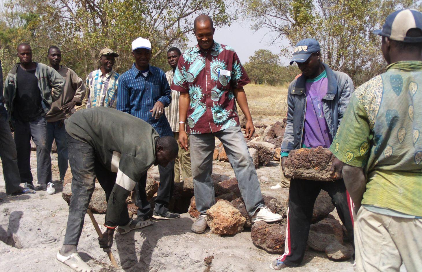
Small dams are installed on minor river beds and are connected up to the riverbanks. Their above-ground dimensions are small, but trench depths can be quite substantial in the case of a subterranean dam two to three metres deep. Plastic sheeting is placed in the trench to stop the water flowing underground.
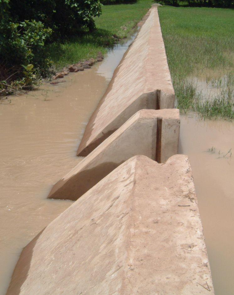
Weirs are low-level structures built in flat valleys as extensions of small dams. Dam walls are low in height, standing from 0.1 m to 1 m above ground level.
The underground section of the dam retains upstream waters. As a result, the ground absorbs water and moisture throughout the entire area affected by the dam. The above-ground section (a watertight wall equipped with outflow gates) discharges the upstream water. It has a weir running along the marigot. Downstream, a stilling basin is installed to prevent erosion caused by the falling water. Using the weir and outflow gates, the water level can be adjusted to the requirements of each rice growing stage. The water retained by a dam equipped with a weir cannot be conserved for long periods. The structure’s main role is to provide water to meet the needs of the rainy-season crops. Even though the trenches are deep and the plastic sheeting prevents underground water dissipation, weirs can help to ensure ground waters are well recharged. This is why farmers should wait before digging wells to extract water for vegetable growing.
Local people formulate the requirement and negotiate with the commune on the investment programme, identify the rules of access and set up the farming cooperatives and management bodies, provide materials and unskilled labour during construction, and undertake small-scale maintenance work. The commune plans investments and assumes overall control of the construction work, delegates management to users, validates the farming rules and oversees their correct application, and undertakes major repairs. Consultancies carry out the socio-economic, environmental and technical studies (scheme design, plans, models), draw up the invitation to tender document and support the tender selection process, and monitor and inspect works. Technical services oversee the application of technical and environmental standards, and participate in ensuring sound financial practices (collection, financial control, public service concessions). Contractors carry out the construction work. The project team provides training (planning, social engineering, studies involving farmers, etc.) and advisory support (organisation of users, formulation and validation of rules, area development plan, plan to develop and exploit value chains).
The scheme can remain functional for up to 20 years provided it is rigorously maintained. The users are divided up into management and maintenance teams and their respective responsibilities are clearly defined.
More than 120 schemes with an average area of 20 hectares were built between 1998 and 2012. These schemes cover an area of more than 2,400 hectares and directly benefit over 15,000 families. The low cost combined with quick returns makes this type of intervention suitable for poor communities and local authorities. These structures can also be installed in dry areas. In these areas, it is essential from the outset that anti-erosion measures are put in place to manage the risk of sand encroachment.
2.3 Photos of the Technology
Media Gallery
2.5 Country/ region/ locations where the Technology has been applied and which are covered by this assessment
Country:
Mali
Region/ State/ Province:
Mali
Further specification of location:
Sikasso region (Yorosso, Koutiala, Sikasso, Kadiolo, Kolondiéba, Bougouni, Yanfolila), Ségou region
Specify the spread of the Technology:
- evenly spread over an area
If precise area is not known, indicate approximate area covered:
- 10-100 km2
Comments:
More than 120 schemes with an average area of 20 hectares were built between 1998 and 2012. These schemes cover an area of more than 2,400 hectares and directly benefit over 15,000 families.
2.6 Date of implementation
If precise year is not known, indicate approximate date:
- 10-50 years ago
2.7 Introduction of the Technology
Specify how the Technology was introduced:
- through projects/ external interventions
Comments (type of project, etc.):
Since 1998, through Helvetas Swiss Intercooperation
3. Classification of the SLM Technology
3.1 Main purpose(s) of the Technology
- improve production
3.2 Current land use type(s) where the Technology is applied
Land use mixed within the same land unit:
Yes
Specify mixed land use (crops/ grazing/ trees):
- Agro-pastoralism (incl. integrated crop-livestock)

Cropland
- Annual cropping
Number of growing seasons per year:
- 1
Specify:
Longest growing period in days: 120, Longest growing period from month to month: August-November

Grazing land

Waterways, waterbodies, wetlands
- Ponds, dams
Comments:
Major land use problems (compiler’s opinion): water loss, aridification, low water table
Livestock density: 1-10 LU /km2
3.4 Water supply
Water supply for the land on which the Technology is applied:
- mixed rainfed-irrigated
3.5 SLM group to which the Technology belongs
- irrigation management (incl. water supply, drainage)
- water diversion and drainage
- surface water management (spring, river, lakes, sea)
3.6 SLM measures comprising the Technology

structural measures
- S5: Dams, pans, ponds
3.7 Main types of land degradation addressed by the Technology

water degradation
- Ha: aridification
- Hs: change in quantity of surface water
- Hg: change in groundwater/aquifer level
Comments:
Main causes of degradation: over abstraction / excessive withdrawal of water (for irrigation, industry, etc.)
3.8 Prevention, reduction, or restoration of land degradation
Specify the goal of the Technology with regard to land degradation:
- prevent land degradation
- reduce land degradation
4. Technical specifications, implementation activities, inputs, and costs
4.1 Technical drawing of the Technology
Technical specifications (related to technical drawing):
Technical knowledge required for field staff / advisors: high
Technical knowledge required for land users: low
Main technical functions: increase of infiltration, increase / maintain water stored in soil, increase of groundwater level / recharge of groundwater, water harvesting / increase water supply, water spreading
Dam/ pan/ pond
Height of bunds/banks/others (m): 1
4.2 General information regarding the calculation of inputs and costs
other/ national currency (specify):
CFA Franc
If relevant, indicate exchange rate from USD to local currency (e.g. 1 USD = 79.9 Brazilian Real): 1 USD =:
517.0
4.3 Establishment activities
| Activity | Timing (season) | |
|---|---|---|
| 1. | It is in community-led planning initiatives that the request for a lowland development scheme takes shape. | |
| 2. | The request is analysed (in consultation with the client community) to ascertain the socio-economic gains for the beneficiaries, the strengths and development potential of the area, and the motivation levels of the actors involved. | |
| 3. | The results are summarised in a report on the ideal development scenarios put forward by local people. Results are fed back to the community at a public meeting | |
| 4. | the findings of the technical diagnostic exercise are developed as a 3D model | |
| 5. | The consultant then moves on to performing economic and financial analyses, which will con- firm the cost effectiveness of the scheme | |
| 6. | A funding agreement is signed by the commune, farmers and project team |
4.4 Costs and inputs needed for establishment
| Specify input | Unit | Quantity | Costs per Unit | Total costs per input | % of costs borne by land users | |
|---|---|---|---|---|---|---|
| Other | total construction | 1.0 | 48703.0 | 48703.0 | ||
| Total costs for establishment of the Technology | 48703.0 | |||||
| Total costs for establishment of the Technology in USD | 94.2 | |||||
4.5 Maintenance/ recurrent activities
| Activity | Timing/ frequency | |
|---|---|---|
| 1. | The design consultancy conducts ongoing supervision of the works to ensure that the standards laid down in the technical dossier are adhered to. It is contractually bound to the commune through a monitoring and supervision contract | |
| 2. | public administration undertakes sporadic inspections to ensure relevant laws are respected |
4.7 Most important factors affecting the costs
Describe the most determinate factors affecting the costs:
The cost of installing these schemes ranges from 5 to 25 million CFA francs (9740-48703 Dollar). With this sum, it is possible to irrigate between 2 and 50 hectares. The cost per hectare stands at around 0.5 to 2 million CFA francs (947-3897 Dollar).
5. Natural and human environment
5.1 Climate
Annual rainfall
- < 250 mm
- 251-500 mm
- 501-750 mm
- 751-1,000 mm
- 1,001-1,500 mm
- 1,501-2,000 mm
- 2,001-3,000 mm
- 3,001-4,000 mm
- > 4,000 mm
Agro-climatic zone
- semi-arid
Thermal climate class: tropics
5.2 Topography
Slopes on average:
- flat (0-2%)
- gentle (3-5%)
- moderate (6-10%)
- rolling (11-15%)
- hilly (16-30%)
- steep (31-60%)
- very steep (>60%)
Landforms:
- plateau/plains
- ridges
- mountain slopes
- hill slopes
- footslopes
- valley floors
Altitudinal zone:
- 0-100 m a.s.l.
- 101-500 m a.s.l.
- 501-1,000 m a.s.l.
- 1,001-1,500 m a.s.l.
- 1,501-2,000 m a.s.l.
- 2,001-2,500 m a.s.l.
- 2,501-3,000 m a.s.l.
- 3,001-4,000 m a.s.l.
- > 4,000 m a.s.l.
5.3 Soils
Soil depth on average:
- very shallow (0-20 cm)
- shallow (21-50 cm)
- moderately deep (51-80 cm)
- deep (81-120 cm)
- very deep (> 120 cm)
Soil texture (topsoil):
- medium (loamy, silty)
- fine/ heavy (clay)
Topsoil organic matter:
- medium (1-3%)
- low (<1%)
5.4 Water availability and quality
Ground water table:
5-50 m
Availability of surface water:
medium
Water quality (untreated):
for agricultural use only (irrigation)
5.5 Biodiversity
Species diversity:
- medium
5.6 Characteristics of land users applying the Technology
Market orientation of production system:
- mixed (subsistence/ commercial)
Off-farm income:
- 10-50% of all income
Relative level of wealth:
- poor
- average
Level of mechanization:
- manual work
Gender:
- men
Indicate other relevant characteristics of the land users:
Population density: < 10 persons/km2
Annual population growth: 2% - 3%
10% of the land users are rich.
50% of the land users are average wealthy.
30% of the land users are poor.
10% of the land users are very poor.
5.7 Average area of land used by land users applying the Technology
- < 0.5 ha
- 0.5-1 ha
- 1-2 ha
- 2-5 ha
- 5-15 ha
- 15-50 ha
- 50-100 ha
- 100-500 ha
- 500-1,000 ha
- 1,000-10,000 ha
- > 10,000 ha
Is this considered small-, medium- or large-scale (referring to local context)?
- small-scale
5.8 Land ownership, land use rights, and water use rights
Comments:
The irrigated land is allocated by the chief
5.9 Access to services and infrastructure
health:
- poor
- moderate
- good
education:
- poor
- moderate
- good
technical assistance:
- poor
- moderate
- good
employment (e.g. off-farm):
- poor
- moderate
- good
markets:
- poor
- moderate
- good
energy:
- poor
- moderate
- good
roads and transport:
- poor
- moderate
- good
drinking water and sanitation:
- poor
- moderate
- good
financial services:
- poor
- moderate
- good
6. Impacts and concluding statements
6.1 On-site impacts the Technology has shown
Socio-economic impacts
Production
crop production
risk of production failure
production area
Income and costs
farm income
Socio-cultural impacts
food security/ self-sufficiency
community institutions
conflict mitigation
reduction of outmigration
contribution to human well-being
Comments/ specify:
At the community level, larger revenues have been generated. Farming yields have doubled, or even tripled, due to the availability of water supplies and the technical support delivered post-build. Watering livestock is now easier and the lowland pastures are more abundant
Ecological impacts
Water cycle/ runoff
water quantity
harvesting/ collection of water
groundwater table/ aquifer
Soil
soil moisture
6.2 Off-site impacts the Technology has shown
wind transported sediments
6.3 Exposure and sensitivity of the Technology to gradual climate change and climate-related extremes/ disasters (as perceived by land users)
Gradual climate change
Gradual climate change
| Season | increase or decrease | How does the Technology cope with it? | |
|---|---|---|---|
| annual temperature | increase | well |
Climate-related extremes (disasters)
Meteorological disasters
| How does the Technology cope with it? | |
|---|---|
| local rainstorm | well |
| local windstorm | well |
Climatological disasters
| How does the Technology cope with it? | |
|---|---|
| drought | well |
Hydrological disasters
| How does the Technology cope with it? | |
|---|---|
| general (river) flood | well |
Other climate-related consequences
Other climate-related consequences
| How does the Technology cope with it? | |
|---|---|
| reduced growing period | well |
6.4 Cost-benefit analysis
How do the benefits compare with the establishment costs (from land users’ perspective)?
Short-term returns:
positive
Long-term returns:
very positive
How do the benefits compare with the maintenance/ recurrent costs (from land users' perspective)?
Short-term returns:
very positive
Long-term returns:
very positive
6.7 Strengths/ advantages/ opportunities of the Technology
| Strengths/ advantages/ opportunities in the compiler’s or other key resource person’s view |
|---|
| The scheme has enabled previously irrigable areas to be rehabilitated and extended. Farming yields have doubled, or even tripled, due to the availability of water supplies and the technical support delivered post-build. The water table has risen (wells no longer dry up). |
| The effect on rice-growing areas is immediate: the retained water allows the agricultural crop cycle to be completed more easily. |
| Several operational scenarios are being implemented (a second and, in some cases, a third growing cycle has been made possible). Sizeable vegetable crops have been produced. Watering livestock is now easier and the lowland pastures are more abundant. |
| At the community level, larger revenues have been generated. The local population is busier throughout the year, which reduces outmigration, particularly among young people. |
| These schemes are simple and low cost. Most local contractors are fully competent in the installation techniques and high-tech equipment is not required. |
6.8 Weaknesses/ disadvantages/ risks of the Technology and ways of overcoming them
| Weaknesses/ disadvantages/ risks in the compiler’s or other key resource person’s view | How can they be overcome? |
|---|---|
| It is important to make it clear to farmers that the water held in these small dam schemes cannot be stored throughout the dry season. | To avoid misunderstandings, users should be heavily involved in the design of the scheme. |
7. References and links
7.1 Methods/ sources of information
- field visits, field surveys
- interviews with land users
When were the data compiled (in the field)?
01/07/2012
7.2 References to available publications
Title, author, year, ISBN:
Intercooperation (2008): Les aménagements de bas-fonds dans le bassin cotonnier de Sikasso. Expérience du programme Jékasy. [Developing lowland areas in the Sikasso cotton-growing basin. The Jékasy programme’s experience]
Title, author, year, ISBN:
Manual of Good Practices in Small Scale Irrigation in the Sahel. Experiences from Mali. Published by GIZ in 2014.
Available from where? Costs?
http://star-www.giz.de/starweb/giz/pub/servlet.starweb
Title, author, year, ISBN:
Rapport collecte de données sur la valorisation des ouvrages réalisés dans le Pôle de Bougouni sur le financement APEL [Data collection report on developing the value of APEL-funded schemes carried out in the Bougouni Hub] – Bougouni, April 2013
Links and modules
Expand all Collapse allLinks
No links
Modules
No modules