Dams with water-spreading weirs [ມາລິ]
- ການສ້າງ:
- ປັບປູງ:
- ຜູ້ສັງລວມຂໍ້ມູນ: Dieter Nill
- ບັນນາທິການ: –
- ຜູ້ທົບທວນຄືນ: Deborah Niggli, Alexandra Gavilano
Barrages avec seuils d’épandage déversant (French)
technologies_1633 - ມາລິ
ເບິ່ງພາກສ່ວນ
ຂະຫຍາຍທັງໝົດ ຍຸບທັງໝົດ1. ຂໍ້ມູນທົ່ວໄປ
1.2 ຂໍ້ມູນ ການຕິດຕໍ່ພົວພັນ ຂອງບຸກຄົນທີ່ສໍາຄັນ ແລະ ສະຖາບັນ ທີ່ມີສ່ວນຮ່ວມ ໃນການປະເມີນເອກກະສານ ເຕັກໂນໂລຢີ
ຜຸ້ຊ່ຽວຊານ ດ້ານການຄຸ້ມຄອງ ທີ່ດິນແບບຍືນຍົງ:
Dembele Celestin
HELVETAS Swiss Intercooperation
ມາລິ
ຜຸ້ຊ່ຽວຊານ ດ້ານການຄຸ້ມຄອງ ທີ່ດິນແບບຍືນຍົງ:
Doumbia Moussa
ADEPE MALI
ມາລິ
ຊື່ໂຄງການ ທີ່ອໍານວຍຄວາມສະດວກ ໃນການສ້າງເອກກະສານ/ປະເມີນ ເຕັກໂນໂລຢີ (ຖ້າກ່ຽວຂ້ອງ)
Manual of Good Practices in Small Scale Irrigation in the Sahel (GIZ )ຊື່ສະຖາບັນ (ຫຼາຍສະຖາບັນ) ທີ່ອໍານວຍຄວາມສະດວກ ໃນການສ້າງເອກກະສານ / ປະເມີນ ເຕັກໂນໂລຢີ (ຖ້າກ່ຽວຂ້ອງ)
Deutsche Gesellschaft für Internationale Zusammenarbeit (GIZ) - ເຢຍລະມັນ1.3 ເງື່ອນໄຂ ກ່ຽວກັບ ການນໍາໃຊ້ຂໍ້ມູນເອກະສານ ທີ່ສ້າງຂື້ນ ໂດຍຜ່ານ ອົງການພາບລວມຂອງໂລກ ທາງດ້ານແນວທາງ ແລະ ເຕັກໂນໂລຢີ ຂອງການອານຸລັກ ທໍາມະຊາດ (WOCAT)
ຜູ້ປ້ອນຂໍ້ມູນ ແລະ ບຸກຄົນສຳຄັນ ທີ່ໃຫ້ຂໍ້ມູນ (ຫຼາຍ) ຍິນຍອມ ຕາມເງື່ອນໄຂ ໃນການນຳໃຊ້ຂໍ້ມູນ ເພື່ອສ້າງເປັນເອກກະສານຂອງ WOCAT:
ແມ່ນ
1.4 ແຈ້ງການວ່າ ດ້ວຍຄວາມຍືນຍົງຂອງ ເຕັກໂນໂລຢີ
ການນໍາໃຊ້ ເຕັກໂນໂລຢີ ດັ່ງກ່າວໄດ້ອະທິບາຍ ເຖິງບັນຫາ ກ່ຽວກັບ ການເຊື່ອມໂຊມຂອງດິນບໍ? ຖ້າບໍ່ດັ່ງນັ້ນ ມັນບໍ່ສາມາດ ຢັ້ງຢືນໄດ້ວ່າ ເປັນເຕັກໂນໂລຊີ ໃນການຄຸ້ມຄອງ ທີ່ດິນແບບຍືນຍົງ? :
ບໍ່ແມ່ນ
2. ການອະທິບາຍ ເຕັກໂນໂລຢີ ຂອງການຄຸ້ມຄອງ ທີ່ດິນແບບຍືນຍົງ
2.1 ຄໍາອະທິບາຍສັ້ນຂອງ ເຕັກໂນໂລຢີ
ການກຳໜົດຄວາມໝາຍ ຂອງເຕັກໂນໂລຢີ:
The role of small dams with weirs is to raise the water table, expand rice growing areas and extend the availability of water in lowland areas to complete the agricultural cycle of lowland areas (rice and vegetable growing).
2.2 ການອະທິບາຍ ລາຍລະອຽດ ຂອງເຕັກໂນໂລຢີ
ການພັນລະນາ:
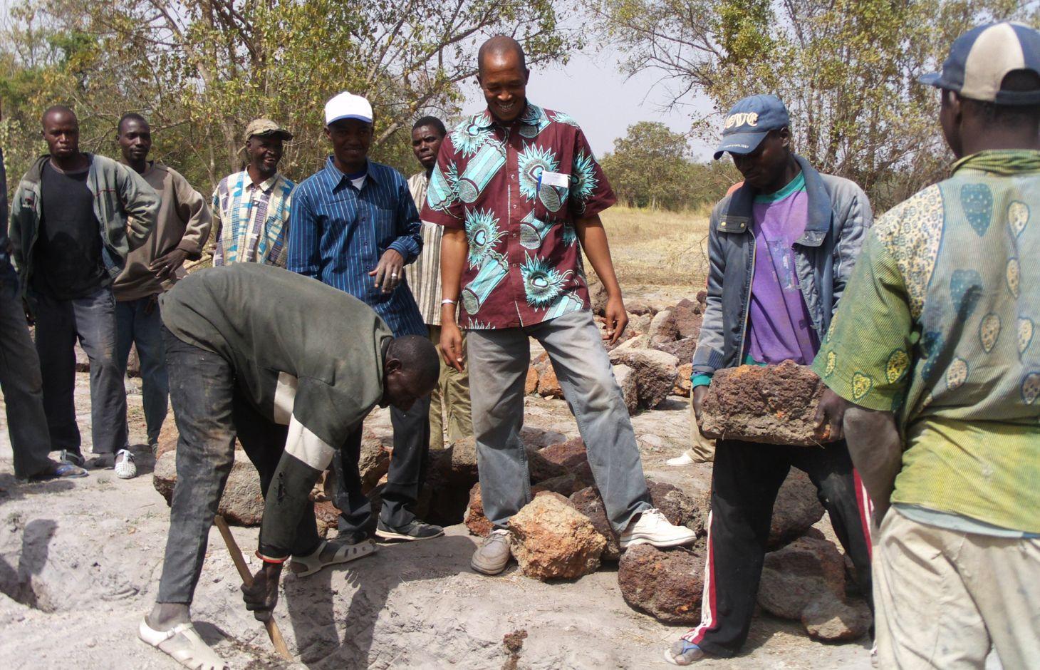
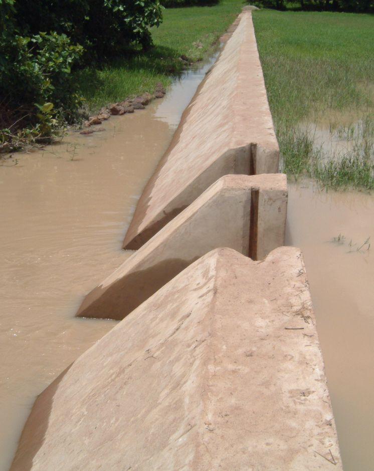
Small dams are installed on minor river beds and are connected up to the riverbanks. Their above-ground dimensions are small, but trench depths can be quite substantial in the case of a subterranean dam two to three metres deep. Plastic sheeting is placed in the trench to stop the water flowing underground.
Weirs are low-level structures built in flat valleys as extensions of small dams. Dam walls are low in height, standing from 0.1 m to 1 m above ground level.
The underground section of the dam retains upstream waters. As a result, the ground absorbs water and moisture throughout the entire area affected by the dam. The above-ground section (a watertight wall equipped with outflow gates) discharges the upstream water. It has a weir running along the marigot. Downstream, a stilling basin is installed to prevent erosion caused by the falling water. Using the weir and outflow gates, the water level can be adjusted to the requirements of each rice growing stage. The water retained by a dam equipped with a weir cannot be conserved for long periods. The structure’s main role is to provide water to meet the needs of the rainy-season crops. Even though the trenches are deep and the plastic sheeting prevents underground water dissipation, weirs can help to ensure ground waters are well recharged. This is why farmers should wait before digging wells to extract water for vegetable growing.
Local people formulate the requirement and negotiate with the commune on the investment programme, identify the rules of access and set up the farming cooperatives and management bodies, provide materials and unskilled labour during construction, and undertake small-scale maintenance work. The commune plans investments and assumes overall control of the construction work, delegates management to users, validates the farming rules and oversees their correct application, and undertakes major repairs. Consultancies carry out the socio-economic, environmental and technical studies (scheme design, plans, models), draw up the invitation to tender document and support the tender selection process, and monitor and inspect works. Technical services oversee the application of technical and environmental standards, and participate in ensuring sound financial practices (collection, financial control, public service concessions). Contractors carry out the construction work. The project team provides training (planning, social engineering, studies involving farmers, etc.) and advisory support (organisation of users, formulation and validation of rules, area development plan, plan to develop and exploit value chains).
The scheme can remain functional for up to 20 years provided it is rigorously maintained. The users are divided up into management and maintenance teams and their respective responsibilities are clearly defined.
More than 120 schemes with an average area of 20 hectares were built between 1998 and 2012. These schemes cover an area of more than 2,400 hectares and directly benefit over 15,000 families. The low cost combined with quick returns makes this type of intervention suitable for poor communities and local authorities. These structures can also be installed in dry areas. In these areas, it is essential from the outset that anti-erosion measures are put in place to manage the risk of sand encroachment.
2.3 ຮູບພາບຂອງເຕັກໂນໂລຢີ
ສື່ຮູບພາບ
2.5 ປະເທດ / ເຂດ / ສະຖານທີ່ບ່ອນທີ່ ເຕັກໂນໂລຢີ ໄດ້ຮັບການນໍາໃຊ້ ແລະ ທີ່ຖືກປົກຄຸມດ້ວຍການປະເມີນຜົນ
ປະເທດ:
ມາລິ
ພາກພື້ນ / ລັດ / ແຂວງ:
Mali
ຂໍ້ມູນເພີ່ມເຕີມຂອງສະຖານທີ່:
Sikasso region (Yorosso, Koutiala, Sikasso, Kadiolo, Kolondiéba, Bougouni, Yanfolila), Ségou region
ໃຫ້ລະບຸ ການແຜ່ຂະຫຍາຍ ເຕັກໂນໂລຢີ:
- ແຜ່ຂະຫຍາຍຢ່າງໄວວາໃນພື້ນທີ່
ຖ້າຫາກບໍ່ຮູ້ເນື້ອທີ່ທີ່ແນ່ນອນ, ໃຫ້ລະບຸ ເນື້ອທີ່ໂດຍປະມານ ທີ່ໃກ້ຄຽງ:
- 10-100 ກມ 2
ຄວາມຄິດເຫັນ:
More than 120 schemes with an average area of 20 hectares were built between 1998 and 2012. These schemes cover an area of more than 2,400 hectares and directly benefit over 15,000 families.
2.6 ວັນທີໃນການຈັດຕັ້ງປະຕິບັດ
ຖ້າຫາກວ່າ ບໍ່ຮູ້ຈັກ ປີທີ່ຊັດເຈນ ແມ່ນໃຫ້ປະມານ ວັນທີເອົາ:
- 10-50 ປີ ຜ່ານມາ
2.7 ການນໍາສະເໜີ ເຕັກໂນໂລຢີ
ໃຫ້ລະບຸ ເຕັກໂນໂລຢີ ໄດ້ຖືກຈັດຕັ້ງປະຕິບັດຄືແນວໃດ?
- ໂດຍຜ່ານໂຄງການ / ການຊ່ວຍເຫຼືອຈາກພາຍນອກ
ຄວາມຄິດເຫັນ (ປະເພດ ໂຄງການ ແລະ ອື່ນໆ):
Since 1998, through Helvetas Swiss Intercooperation
3. ການໃຈ້ແຍກ ເຕັກໂນໂລຢີ ໃນການຄຸ້ມຄອງ ດິນແບບຍືນຍົງ
3.1 ຈຸດປະສົງຫຼັກ (ຫຼາຍ) ຂອງເຕັກໂນໂລຢີ
- ປັບປຸງ ການຜະລິດ
3.2 ປະເພດການນໍາໃຊ້ທີ່ດິນ ໃນປະຈຸບັນ() ທີ່ເຕັກໂນໂລຢີ ໄດ້ຖືກນໍາໃຊ້
ການນຳໃຊ້ທີ່ດິນ ປະສົມພາຍໃນພື້ນທີ່ດຽວກັນ:
ແມ່ນ
ລະບຸການນຳໃຊ້ທີ່ດິນແບບປະສົມ (ຜົນລະປູກ / ທົ່ງຫຍ້າລ້ຽງສັດ / ຕົ້ນໄມ້):
- ກະສິກໍາແບບປະສົມປະສານ (ລວມທັງ ການລ້ຽງສັດ-ປຸກຝັງ)

ດິນທີ່ປູກພືດ
- ການປູກພືດປະຈໍາປີ
ຈໍານວນ ລະດູການ ປູກໃນປີໜຶ່ງ:
- 1
ລະບຸ ຊະນິດ:
Longest growing period in days: 120, Longest growing period from month to month: August-November

ທົ່ງຫຍ້າລ້ຽງສັດ

ທິດທາງໄຫຼຂອງນໍ້າ, ນໍ້າ, ດິນທາມ
- ໜອງ, ເຂື່ອນໄຟຟ້າ
ຄວາມຄິດເຫັນ:
Major land use problems (compiler’s opinion): water loss, aridification, low water table
Livestock density: 1-10 LU /km2
3.4 ການສະໜອງນ້ຳ
ການສະໜອງນໍ້າ ໃນພື້ນທີ່ ທີ່ໄດ້ນໍາໃຊ້ ເຕັກໂນໂລຢີ:
- ປະສົມປະສານ ກັນລະຫວ່າງ ນໍ້າຝົນ ແລະ ນໍ້າຊົນລະປະທານ
3.5 ການນໍາໃຊ້ເຕັກໂນໂລຢີ ທີ່ຢູ່ໃນກຸ່ມການຄຸ້ມຄອງ ທີ່ດິນແບບຍືນຍົງ
- ການຄຸ້ມຄອງຊົນລະປະທານ (ການສະໜອງນໍ້າ, ລະບາຍ)
- ຄວາມຫຼາກຫຼາຍຂອງນໍ້າ ແລະ ການລະບາຍ
- ການຄຸ້ມຄອງນໍ້າໜ້າດິນ (ນ້ຳຈາກພຸ, ແມ່ນໍ້າ, ທະເລສາບ, ທະເລ)
3.6 ມາດຕະການ ການຄຸ້ມຄອງ ທີ່ດິນແບບຍືນຍົງ ປະກອບດ້ວຍ ເຕັກໂນໂລຢີ

ມາດຕະການໂຄງສ້າງ
- S5: ເຂື່ອນໄຟຟ້າ, ຝາຍເກັບນໍ້າ, ອ່າງ, ໜອງ
3.7 ປະເພດດິນເຊື່ອມໂຊມ ຫຼັກທີ່ໄດ້ນໍາໃຊ້ ເຕັກໂນໂລຢີ

ການເຊື່ອມໂຊມ ຂອງນໍ້າ
- Ha: ສະພາບແຫ້ງແລ້ງ
- Hs: ການປ່ຽນແປງ ປະລິມານ ນໍ້າໜ້າດິນ
- Hg: ການປ່ຽນແປງ ລະດັບນ້ຳໃຕ້ດິນ ຫຼື ນ້ຳບາດານ
ຄວາມຄິດເຫັນ:
Main causes of degradation: over abstraction / excessive withdrawal of water (for irrigation, industry, etc.)
3.8 ການປ້ອງກັນ, ການຫຼຸດຜ່ອນ, ຫຼືການຟື້ນຟູຂອງການເຊື່ອມໂຊມຂອງດິນ
ໃຫ້ລະບຸ ເປົ້າໝາຍ ເຕັກໂນໂລຢີ ທີ່ພົວພັນ ກັບຄວາມເຊື່ອມໂຊມຂອງດິນ:
- ປ້ອງກັນການເຊື່ອມໂຊມຂອງດິນ
- ຫຼຸດຜ່ອນການເຊື່ອມໂຊມຂອງດິນ
4. ຂໍ້ກໍາໜົດ, ກິດຈະກໍາການປະຕິບັດ, ວັດຖຸດິບ, ແລະຄ່າໃຊ້ຈ່າຍ
4.1 ເຕັກນິກ ໃນການແຕ້ມແຜນວາດ ເຕັກໂນໂລຢີ
ຄຸນລັກສະນະ ຂອງເຕັກນິກ (ທີ່ກ່ຽວຂ້ອງ ກັບການແຕ້ມແຜນວາດ ທາງດ້ານເຕັກນີກ):
Technical knowledge required for field staff / advisors: high
Technical knowledge required for land users: low
Main technical functions: increase of infiltration, increase / maintain water stored in soil, increase of groundwater level / recharge of groundwater, water harvesting / increase water supply, water spreading
Dam/ pan/ pond
Height of bunds/banks/others (m): 1
4.2 ຂໍ້ມູນທົ່ວໄປກ່ຽວກັບການຄິດໄລ່ປັດໃຈຂາເຂົ້າໃນການຜະລິດ ແລະ ມູນຄ່າອື່ນໆ
ສະກຸນເງິນອື່ນໆ / ປະເທດອື່ນໆ (ລະບຸ):
CFA Franc
ຖ້າກ່ຽວຂ້ອງ, ໃຫ້ລະບຸອັດຕາແລກປ່ຽນຈາກ USD ເປັນສະກຸນເງິນທ້ອງຖິ່ນ (ເຊັ່ນ: 1 USD = 79.9 Brazilian Real): 1 USD =:
517.0
4.3 ການສ້າງຕັ້ງກິດຈະກໍາ
| ກິດຈະກໍາ | Timing (season) | |
|---|---|---|
| 1. | It is in community-led planning initiatives that the request for a lowland development scheme takes shape. | |
| 2. | The request is analysed (in consultation with the client community) to ascertain the socio-economic gains for the beneficiaries, the strengths and development potential of the area, and the motivation levels of the actors involved. | |
| 3. | The results are summarised in a report on the ideal development scenarios put forward by local people. Results are fed back to the community at a public meeting | |
| 4. | the findings of the technical diagnostic exercise are developed as a 3D model | |
| 5. | The consultant then moves on to performing economic and financial analyses, which will con- firm the cost effectiveness of the scheme | |
| 6. | A funding agreement is signed by the commune, farmers and project team |
4.4 ຕົ້ນທຶນ ແລະ ປັດໄຈຂາເຂົ້າທີ່ຈໍາເປັນໃນຈັດຕັ້ງປະຕິບັດ
| ລະບຸ ປັດໃຈ ນໍາເຂົ້າ ໃນການຜະລີດ | ຫົວໜ່ວຍ | ປະລິມານ | ຕົ້ນທຶນ ຕໍ່ຫົວໜ່ວຍ | ຕົ້ນທຶນທັງໝົດ ຂອງປັດໃຈຂາເຂົ້າ ໃນການຜະລິດ | % ຂອງຕົ້ນທຶນທັງໝົດ ທີ່ຜູ້ນໍາໃຊ້ທີ່ດິນ ໃຊ້ຈ່າຍເອງ | |
|---|---|---|---|---|---|---|
| ອື່ນໆ | total construction | 1.0 | 48703.0 | 48703.0 | ||
| ຕົ້ນທຶນທັງໝົດ ໃນການຈັດຕັ້ງປະຕິບັດ ເຕັກໂນໂລຢີ | 48703.0 | |||||
| ຄ່າໃຊ້ຈ່າຍທັງໝົດ ສຳລັບການສ້າງຕັ້ງເຕັກໂນໂລຢີ ເປັນສະກຸນເງີນໂດລາ | 94.2 | |||||
4.5 ບໍາລຸງຮັກສາ / ແຜນຈັດຕັ້ງປະຕິບັດ ກິດຈະກໍາ
| ກິດຈະກໍາ | ໄລຍະເວລາ / ຄວາມຖີ່ | |
|---|---|---|
| 1. | The design consultancy conducts ongoing supervision of the works to ensure that the standards laid down in the technical dossier are adhered to. It is contractually bound to the commune through a monitoring and supervision contract | |
| 2. | public administration undertakes sporadic inspections to ensure relevant laws are respected |
4.7 ປັດໄຈ ທີ່ສໍາຄັນ ທີ່ສົ່ງຜົນກະທົບ ຕໍ່ຄ່າໃຊ້ຈ່າຍ
ໃຫ້ອະທິບາຍ ປັດໃຈ ທີ່ສົ່ງຜົນກະທົບ ຕໍ່ຕົ້ນທຶນ ໃນການຈັດຕັ້ງປະຕິບັດ:
The cost of installing these schemes ranges from 5 to 25 million CFA francs (9740-48703 Dollar). With this sum, it is possible to irrigate between 2 and 50 hectares. The cost per hectare stands at around 0.5 to 2 million CFA francs (947-3897 Dollar).
5. ສະພາບແວດລ້ອມທໍາມະຊາດ ແລະ ມະນຸດ
5.1 ອາກາດ
ປະລິມານນໍ້າຝົນປະຈໍາປີ
- < 250 ມີລິແມັດ
- 251-500 ມີລິແມັດ
- 501-750 ມີລິແມັດ
- 751-1,000 ມີລິແມັດ
- 1,001-1,500 ມີລິແມັດ
- 1,501-2,000 ມີລິແມັດ
- 2,001-3,000 ມີລິແມັດ
- 3,001-4,000 ມີລິແມັດ
- > 4,000 ມີລິແມັດ
ເຂດສະພາບອາກາດກະສິກໍາ
- ເຄິ່ງແຫ້ງແລ້ງ
Thermal climate class: tropics
5.2 ພູມິປະເທດ
ຄ່າສະເລ່ຍ ຄວາມຄ້ອຍຊັນ:
- ພື້ນທີ່ຮາບພຽງ (0-2%)
- ອ່ອນ (3-5 %)
- ປານກາງ (6-10 %)
- ມ້ວນ (11-15 %)
- ເນີນ(16-30%)
- ໍຊັນ (31-60%)
- ຊັນຫຼາຍ (>60%)
ຮູບແບບຂອງດິນ:
- ພູພຽງ / ທົ່ງພຽງ
- ສັນພູ
- ເປີ້ນພູ
- ເນີນພູ
- ຕີນພູ
- ຮ່ອມພູ
ເຂດລະດັບສູງ:
- 0-100 ແມັດ a.s.l.
- 101-500 ແມັດ a.s.l.
- 501-1,000 ແມັດ a.s.l.
- 1,001-1,500 ແມັດ a.s.l.
- 1,501-2,000 ແມັດ a.s.l.
- 2,001-2,500 ແມັດ a.s.l.
- 2,501-3,000 ແມັດ a.s.l.
- 3,001-4,000 ແມັດ a.s.l.
- > 4,000 ແມັດ a.s.l.
5.3 ດິນ
ຄວາມເລິກ ຂອງດິນສະເລ່ຍ:
- ຕື້ນຫຼາຍ (0-20 ຊັງຕີແມັດ)
- ຕື້ນ (21-50 ຊຕມ)
- ເລີກປານກາງ (51-80 ຊຕມ)
- ເລິກ (81-120 ຊມ)
- ເລິກຫຼາຍ (> 120 cm)
ເນື້ອດິນ (ໜ້າດິນ):
- ປານກາງ (ດິນໜຽວ, ດິນໂຄນ)
- ບາງລະອຽດ / ໜັກ (ໜຽວ)
ຊັ້ນອິນຊີວັດຖຸ ເທິງໜ້າດິນ:
- ປານກາງ (1-3 %)
- ຕໍາ່ (<1 %)
5.4 ມີນໍ້າ ແລະ ຄຸນນະພາບ
ລະດັບ ນໍ້າໃຕ້ດິນ:
5-50 ແມັດ
ການມີນໍ້າ ເທິງໜ້າດິນ:
ປານກາງ
ຄຸນນະພາບນໍ້າ (ບໍ່ມີການບໍາບັດ):
ນຳໃຊ້ເຂົ້າໃນການຜະລິດກະສິກໍາພຽງຢ່າງດຽງ (ຊົນລະປະທານ)
5.5 ຊີວະນາໆພັນ
ຄວາມຫຼາກຫຼາຍ ທາງສາຍພັນ:
- ປານກາງ
5.6 ຄຸນລັກສະນະ ຂອງຜູ້ນໍາໃຊ້ທີ່ດິນ ທີ່ໄດ້ນໍາໃຊ້ເຕັກໂນໂລຢີ
ລະບົບ ການຕະຫຼາດ ແລະ ຜົນຜະລິດ:
- ປະສົມປົນເປ( ກຸ້ມຕົນເອງ/ເປັນສິນຄ້າ)
ລາຍຮັບ ທີ່ບໍ່ໄດ້ມາຈາກ ການຜະລິດ ກະສິກໍາ:
- 10-50 % ຂອງລາຍຮັບທັງໝົດ
ລະດັບຄວາມຮັ່ງມີ:
- ທຸກຍາກ
- ສະເລ່ຍ
ລະດັບ ການຫັນເປັນກົນຈັກ:
- ການໃຊ້ແຮງງານຄົນ
ເພດ:
- ຜູ້ຊາຍ
ໃຫ້ລະບຸ ຄຸນລັກສະນະ ຂອງຜູ້ນໍາໃຊ້ທີ່ດິນ:
Population density: < 10 persons/km2
Annual population growth: 2% - 3%
10% of the land users are rich.
50% of the land users are average wealthy.
30% of the land users are poor.
10% of the land users are very poor.
5.7 ເນື້ອທີ່ສະເລ່ຍຂອງດິນ ທີ່ຜູ້ນຳໃຊ້ທີ່ດິນ ໃຊ້ເຮັດເຕັກໂນໂລຢີ
- <0.5 ເຮັກຕາ
- 0.5-1 ເຮັກຕາ
- 1-2 ເຮັກຕາ
- 2-5 ເຮັກຕາ
- 5-15 ເຮັກຕາ
- 15-50 ເຮັກຕາ
- 50-100 ເຮັກຕາ
- 100-500 ເຮັກຕາ
- 500-1,000 ເຮັກຕາ
- 1,000-10,000 ເຮັກຕາ
- > 10,000 ເຮັກຕາ
ຖືໄດ້ວ່າ ເປັນຂະໜາດນ້ອຍ, ກາງ ຫຼື ໃຫຍ່ (ອີງຕາມເງື່ອນໄຂ ສະພາບຄວາມເປັນຈິງ ຂອງທ້ອງຖີ່ນ)? :
- ຂະໜາດນ້ອຍ
5.8 ເຈົ້າຂອງທີ່ດິນ, ສິດໃຊ້ທີ່ດິນ, ແລະ ສິດທິການນໍາໃຊ້ນໍ້າ
ຄວາມຄິດເຫັນ:
The irrigated land is allocated by the chief
5.9 ການເຂົ້າເຖິງການບໍລິການ ແລະ ພື້ນຖານໂຄງລ່າງ
ສຸຂະພາບ:
- ທຸກຍາກ
- ປານກາງ
- ດີ
ການສຶກສາ:
- ທຸກຍາກ
- ປານກາງ
- ດີ
ການຊ່ວຍເຫຼືອ ດ້ານວິຊາການ:
- ທຸກຍາກ
- ປານກາງ
- ດີ
ການຈ້າງງານ (ຕົວຢ່າງ, ການເຮັດກິດຈະກໍາອື່ນ ທີ່ບໍ່ແມ່ນ ການຜະລິດກະສິກໍາ):
- ທຸກຍາກ
- ປານກາງ
- ດີ
ຕະຫຼາດ:
- ທຸກຍາກ
- ປານກາງ
- ດີ
ພະລັງງານ:
- ທຸກຍາກ
- ປານກາງ
- ດີ
ຖະໜົນຫົນທາງ ແລະ ການຂົນສົ່ງ:
- ທຸກຍາກ
- ປານກາງ
- ດີ
ການດື່ມນໍ້າ ແລະ ສຸຂາພິບານ:
- ທຸກຍາກ
- ປານກາງ
- ດີ
ການບໍລິການ ທາງດ້ານການເງິນ:
- ທຸກຍາກ
- ປານກາງ
- ດີ
6. ຜົນກະທົບ ແລະ ລາຍງານສະຫຼຸບ
6.1 ການສະແດງຜົນກະທົບ ພາຍໃນພື້ນທີ່ ທີ່ໄດ້ຈັດຕັ້ງປະຕິບັດ ເຕັກໂນໂລຢີ
ຜົນກະທົບທາງເສດຖະກິດສັງຄົມ
ການຜະລິດ
ການຜະລິດພືດ
ຄວາມສ່ຽງ ຕໍ່ຜົນຜະລິດ
ເນື້ອທີ່ການຜະລິດ
ລາຍໄດ້ ແລະ ຄ່າໃຊ້ຈ່າຍ
ລາຍຮັບ ຈາກການຜະລີດ
ຜົນກະທົບດ້ານວັດທະນາທໍາສັງຄົມ
ການຄໍ້າປະກັນ ສະບຽງອາຫານ / ກຸ້ມຢູ່ກຸ້ມກິນ
ສະຖາບັນ ການຈັດຕັ້ງຊຸມຊົນ
ການຫຼຸດຜ່ອນ ຂໍ້ຂັດແຍ່ງ
reduction of outmigration
contribution to human well-being
ຄວາມຄິດເຫັນ / ລະບຸແຈ້ງ:
At the community level, larger revenues have been generated. Farming yields have doubled, or even tripled, due to the availability of water supplies and the technical support delivered post-build. Watering livestock is now easier and the lowland pastures are more abundant
ຜົນກະທົບຕໍ່ລະບົບນິເວດ
ວົງຈອນນໍ້າ / ນໍ້າ
ປະລິມານນໍ້າ
ການຂຸດຄົ້ນ / ການເກັບກັກນໍ້າ
ຊັ້ນນໍ້າໄຕ້ດິນ / ນໍ້າ
ດິນ
ຄວາມຊຸ່ມຂອງດິນ
6.2 ຜົນກະທົບທາງອ້ອມ ຈາກການນໍາໃຊ້ເຕັກໂນໂລຢີ
ລົມ ທີ່ພັດເອົາຕະກອນ
6.3 ການປ້ອງກັນ ແລະ ຄວາມບອບບາງ ຂອງເຕັກໂນໂລຢິ ໃນການປ່ຽນແປງສະພາບດິນຟ້າອາກາດ ແລະ ກ່ຽວຂ້ອງກັບອາກາດທີ່ມີການປ່ຽນແປງທີ່ຮຸນແຮງ / ໄພພິບັດທາງທໍາມະຊາດ (ຮັບຮູ້ໄດ້ໂດຍຜູ້ນໍາໃຊ້ທີ່ດິນ)
ການປ່ຽນແປງດິນຟ້າອາກາດ ເທື່ອລະກ້າວ
ການປ່ຽນແປງດິນຟ້າອາກາດ ເທື່ອລະກ້າວ
| ລະດູການ | ເພີ່ມຂື້ນ ຫຼື ຫຼຸດລົງ | ການນໍາໃຊ້ ເຕັກໂນໂລຢີ ສາມາດ ຮັບມື ໄດ້ຄືແນວໃດ? | |
|---|---|---|---|
| ອຸນຫະພູມປະຈໍາປີ | ເພີ່ມຂື້ນ | ດີ |
ອາກາດ ທີ່ກ່ຽວພັນກັບຄວາມຮຸນແຮງ (ໄພພິບັດທາງທໍາມະຊາດ)
ໄພພິບັດທາງອຸຕຸນິຍົມ
| ການນໍາໃຊ້ ເຕັກໂນໂລຢີ ສາມາດ ຮັບມື ໄດ້ຄືແນວໃດ? | |
|---|---|
| ພະຍຸຝົນ | ດີ |
| ພາຍຸລົມທ້ອງຖິ່ນ | ດີ |
ໄພພິບັດທາງພູມອາກາດ
| ການນໍາໃຊ້ ເຕັກໂນໂລຢີ ສາມາດ ຮັບມື ໄດ້ຄືແນວໃດ? | |
|---|---|
| ແຫ້ງແລ້ງ | ດີ |
ໄພພິບັດທາງອຸທົກກະສາກ
| ການນໍາໃຊ້ ເຕັກໂນໂລຢີ ສາມາດ ຮັບມື ໄດ້ຄືແນວໃດ? | |
|---|---|
| ໂດຍທົ່ວໄປ (ແມ່ນໍ້າ) ນໍ້າຖ້ວມ | ດີ |
ຜົນສະທ້ອນສະພາບອາກາດອື່ນໆທີ່ກ່ຽວຂ້ອງ
ຜົນສະທ້ອນສະພາບອາກາດອື່ນໆທີ່ກ່ຽວຂ້ອງ
| ການນໍາໃຊ້ ເຕັກໂນໂລຢີ ສາມາດ ຮັບມື ໄດ້ຄືແນວໃດ? | |
|---|---|
| ໄລຍະເວລາການຂະຫຍາຍຕົວຫຼຸດລົງ | ດີ |
6.4 ການວິເຄາະຕົ້ນທຶນ ແລະ ຜົນປະໂຫຍດ
ຈະເຮັດປະໂຫຍດເພື່ອປຽບທຽບກັບຄ່າໃຊ້ຈ່າຍກັບສິ່ງກໍ່ສ້າງ (ຈາກທັດສະນະຂອງຜູ້ນຳໃຊ້ທີ່ດິນ) ໄດ້ແນວໃດ?
ຜົນຕອບແທນ ໃນໄລຍະສັ້ນ:
ຜົນກະທົບທາງບວກ
ຜົນຕອບແທນ ໃນໄລຍະຍາວ:
ຜົນກະທົບທາງບວກຫຼາຍ
ຈະໄດ້ຮັບຜົນປະໂຫຍດເມື່ອປຽບທຽບກັບ / ຄ່າໃຊ້ຈ່າຍໃນການບຳລຸງຮັກສາທີເ່ກີດຂື້ນອິກ (ຈາກທັດສະນະຄະຕິຂອງຜູ້ນຳໃຊ້ທີ່ດິນ) ໄດ້ແນວໃດ?
ຜົນຕອບແທນ ໃນໄລຍະສັ້ນ:
ຜົນກະທົບທາງບວກຫຼາຍ
ຜົນຕອບແທນ ໃນໄລຍະຍາວ:
ຜົນກະທົບທາງບວກຫຼາຍ
6.7 ຈຸດແຂງ / ຂໍ້ດີ / ໂອກາດ ໃນການນໍາໃຊ້ ເຕັກໂນໂລຢີ
| ຈຸດແຂງ / ຈຸດດີ / ໂອກາດ ຈາກທັດສະນະຂອງຜູ້ປ້ອນຂໍ້ມູນ ຫຼື ບຸກຄົນສຳຄັນ |
|---|
| The scheme has enabled previously irrigable areas to be rehabilitated and extended. Farming yields have doubled, or even tripled, due to the availability of water supplies and the technical support delivered post-build. The water table has risen (wells no longer dry up). |
| The effect on rice-growing areas is immediate: the retained water allows the agricultural crop cycle to be completed more easily. |
| Several operational scenarios are being implemented (a second and, in some cases, a third growing cycle has been made possible). Sizeable vegetable crops have been produced. Watering livestock is now easier and the lowland pastures are more abundant. |
| At the community level, larger revenues have been generated. The local population is busier throughout the year, which reduces outmigration, particularly among young people. |
| These schemes are simple and low cost. Most local contractors are fully competent in the installation techniques and high-tech equipment is not required. |
6.8 ຈຸດອ່ອນ / ຂໍ້ເສຍ / ຄວາມສ່ຽງ ໃນການນໍາໃຊ້ ເຕັກໂນໂລຢີ ແລະ ວິທີການແກ້ໄຂບັນຫາ
| ຈຸດອ່ອນ/ຂໍ້ບົກຜ່ອງ/ຄວາມສ່ຽງ ຈາກທັດສະນະຂອງຜູ້ປ້ອນຂໍ້ມູນ ຫຼື ບຸກຄົນສຳຄັນ | ມີວິທີການແກ້ໄຂຄືແນວໃດ? |
|---|---|
| It is important to make it clear to farmers that the water held in these small dam schemes cannot be stored throughout the dry season. | To avoid misunderstandings, users should be heavily involved in the design of the scheme. |
7. ເອກະສານອ້າງອີງ ແລະ ການເຊື່ອມຕໍ່
7.1 ວິທີການ / ແຫຼ່ງຂໍ້ມູນ
- ການໄປຢ້ຽມຢາມພາກສະໜາມ, ການສໍາຫຼວດພາກສະໜາມ
- ການສໍາພາດ ຜູ້ນໍາໃຊ້ທີ່ດິນ
ເມື່ອໃດທີ່ໄດ້ສັງລວມຂໍ້ມູນ (ຢູ່ພາກສະໜາມ)?
01/07/2012
7.2 ເອກກະສານອ້າງອີງທີ່ເປັນບົດລາຍງານ
ຫົວຂໍ້, ຜູ້ຂຽນ, ປີ, ISBN:
Intercooperation (2008): Les aménagements de bas-fonds dans le bassin cotonnier de Sikasso. Expérience du programme Jékasy. [Developing lowland areas in the Sikasso cotton-growing basin. The Jékasy programme’s experience]
ຫົວຂໍ້, ຜູ້ຂຽນ, ປີ, ISBN:
Manual of Good Practices in Small Scale Irrigation in the Sahel. Experiences from Mali. Published by GIZ in 2014.
ມີຢູ່ໃສ?ມູນຄ່າເທົ່າໃດ?
http://star-www.giz.de/starweb/giz/pub/servlet.starweb
ຫົວຂໍ້, ຜູ້ຂຽນ, ປີ, ISBN:
Rapport collecte de données sur la valorisation des ouvrages réalisés dans le Pôle de Bougouni sur le financement APEL [Data collection report on developing the value of APEL-funded schemes carried out in the Bougouni Hub] – Bougouni, April 2013
ຂໍ້ມູນການເຊື່ອມຕໍ່ ແລະ ເນື້ອໃນ
ຂະຫຍາຍທັງໝົດ ຍຸບທັງໝົດການເຊື່ອມຕໍ່
ບໍ່ມີຂໍ້ມູນການເຊື່ອມຕໍ່
ເນື້ອໃນ
ບໍ່ມີເນື້ອໃນ