Stone wall [Afghanistan]
- Creation:
- Update:
- Compiler: Aqila Haidery
- Editor: –
- Reviewer: Alexandra Gavilano
Diwar Sangi (Dari)
technologies_1723 - Afghanistan
View sections
Expand all Collapse all1. General information
1.2 Contact details of resource persons and institutions involved in the assessment and documentation of the Technology
SLM specialist:
SLM specialist:
SLM specialist:
Burger Sieger
SLM specialist:
Saadat Alemi
SLM specialist:
Zainullah Hazem
SLM specialist:
Hussein Muhammadi
SLM specialist:
Zekrullah Ahmedi
SLM specialist:
Reza Ahmedi
SLM specialist:
Ershad Mustafa
Catholic Relief Service
Afghanistan
Name of the institution(s) which facilitated the documentation/ evaluation of the Technology (if relevant)
HELVETAS (Swiss Intercooperation)Name of the institution(s) which facilitated the documentation/ evaluation of the Technology (if relevant)
Catholic Relief Services/East Africa (Catholic Relief Services/East Africa) - Kenya1.3 Conditions regarding the use of data documented through WOCAT
The compiler and key resource person(s) accept the conditions regarding the use of data documented through WOCAT:
Yes
1.5 Reference to Questionnaire(s) on SLM Approaches (documented using WOCAT)
Community-Based Watershed Management [Afghanistan]
Sustainable implementation of watershed management through appropriate SLM technologies, formation of organizational structures and capacity building of stakeholders
- Compiler: Aqila Haidery
2. Description of the SLM Technology
2.1 Short description of the Technology
Definition of the Technology:
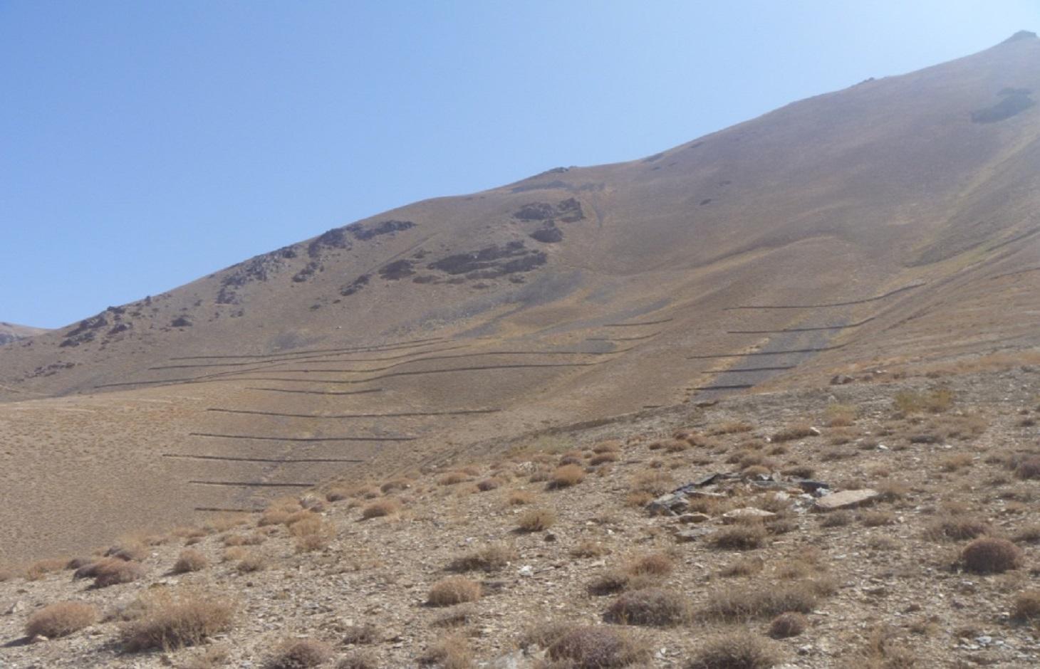
Contour stone walls constructed on moderate to steep slopes to retain water and sediments and trap snow.
2.2 Detailed description of the Technology
Description:
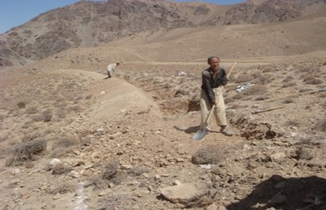
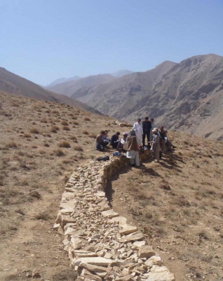
The Stone wall technology is documented by Sustainable Land Management Project/HELVETAS Swiss Intercooperation with financial support of Swiss Agency for Development and Cooperation(SDC) and close support and cooperation of the Catholic Relief Service (CRS). The technology was applied in community land in Sar e Ahangaran (Siakhar Toghai) watershed which drains into the main Bamyan valley forming part of the Kunduz watershed of the Amu Darya river basin. The project was initiated by CRS (Catholic Relief Services) in October 2009 and the participating families were involved in each stage of intervention, including surveys, design, and implementation and monitoring.
Purpose of the Technology: The main function of stone wall is to trap snow and control run-off. Through construction work, many families received income through cash for work. About 21,519 USD were spent on the technology, with 90% contribution from CRS and 10% from the participating community. The cost for implementing Stone Wall technology was about 2,390 USD/ha.
Establishment / maintenance activities and inputs: The technology was applied in extensive grazing land. The stone wall technology is not new to the farmers of Sar e Ahangaran (Siakhar Toghai) as they have applied it in their private croplands as well. CRS built on this traditional technology and improved it by applying it along contour lines demarcated with A-frame and establishing it a more technically sound manner. The technology is effective in reducing snow avalanches, surface run-off, sediments, and downstream flooding leading to more crop production and less destruction of property and crops. It is tolerant to increasing or decreasing temperature and droughts. If constructed properly along the contour, the technology is not impacted by heavy rainfall or severe flash floods.
Natural / human environment: The technology was applied on hill and mountain slopes at 3000-3500 m elevation. The average annual rainfall in the area is 250-500 mm. The longest growing period is 6 months, i.e. from April to September. Due to its proximity to the Koh-i-Baba mountains, the area experiences long, severe winters of around 6 months (Mid-October to mid-April).
The participating families are poor; 10-50 % of their income is from off-farm activities, e.g. labour, migration. The villagers have moderate access to health, education, technical assistance, drinking water and sanitation facilities. Accessibility to employment, markets, energy, good roads and financial services is poor. The production system is subsistence-oriented and non-subsidized.
The effectiveness of stone wall technology was strengthened through other SLM measures, including contour trench bund, gully plugs, shrub cutting and grazing control, planting trees below the walls, and re-sowing with improved fodder species.
2.3 Photos of the Technology
Media Gallery
2.5 Country/ region/ locations where the Technology has been applied and which are covered by this assessment
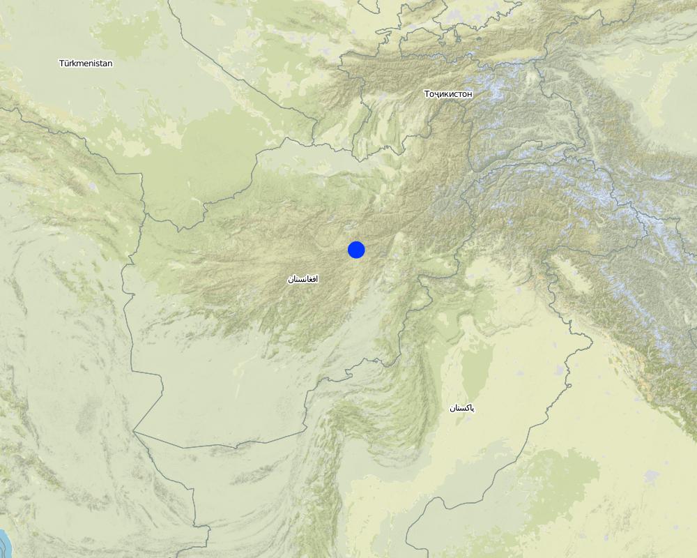
Country:
Afghanistan
Region/ State/ Province:
Sar-e-Ahangaran, Bamyan, Afghanistan
Specify the spread of the Technology:
- applied at specific points/ concentrated on a small area
Map
×2.6 Date of implementation
If precise year is not known, indicate approximate date:
- 10-50 years ago
2.7 Introduction of the Technology
Specify how the Technology was introduced:
- during experiments/ research
3. Classification of the SLM Technology
3.1 Main purpose(s) of the Technology
- reduce, prevent, restore land degradation
- reduce risk of disasters
3.2 Current land use type(s) where the Technology is applied
Land use mixed within the same land unit:
No

Grazing land
Extensive grazing:
- Nomadism
Intensive grazing/ fodder production:
- Cut-and-carry/ zero grazing
Comments:
Major land use problems (compiler’s opinion): Degradation of slopes due to biotic pressures such as overgrazing, extraction of bushes for fuel and cultivation leading to snow avalanche, flash floods and decrease in spring water quantity. Lack of soil and water conservation measures on slopes contribute to low production from agriculture and pasture lands.
Future (final) land use (after implementation of SLM Technology): Grazing land: Gi: Intensive grazing/ fodder production
3.3 Has land use changed due to the implementation of the Technology?
Has land use changed due to the implementation of the Technology?
- Yes (Please fill out the questions below with regard to the land use before implementation of the Technology)
Grazing land
- Extensive grazing
3.4 Water supply
Water supply for the land on which the Technology is applied:
- mixed rainfed-irrigated
3.5 SLM group to which the Technology belongs
- cross-slope measure
3.6 SLM measures comprising the Technology

structural measures
- S6: Walls, barriers, palisades, fences
3.7 Main types of land degradation addressed by the Technology

biological degradation
- Bc: reduction of vegetation cover
Comments:
Main causes of degradation: over-exploitation of vegetation for domestic use, overgrazing, Contamination of water due to floods
3.8 Prevention, reduction, or restoration of land degradation
Specify the goal of the Technology with regard to land degradation:
- reduce land degradation
4. Technical specifications, implementation activities, inputs, and costs
4.1 Technical drawing of the Technology
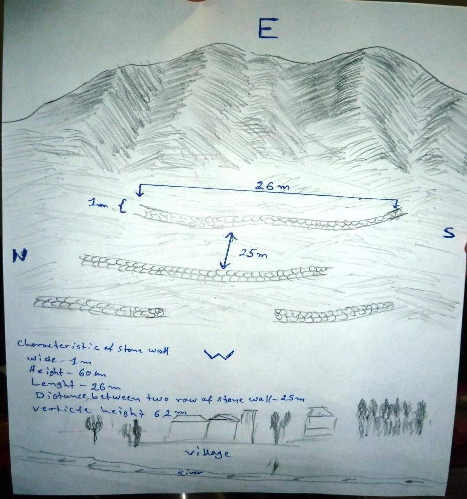
Technical specifications (related to technical drawing):
The hand drawing shows the dimensions of the technology, spacing, area’s borders and as well as the downstream area.
Stone wall dimensions are as follows:
length: 26 m; width: 1m; height: 60 cm; foundation: 30cm in depth.
Technical knowledge required for field staff / advisors: low
Technical knowledge required for land users: moderate
Main technical functions: control of dispersed runoff: impede / retard, reduction of slope length, Reduction of snow avalanches
Secondary technical functions: Improvement of ground cover due to less soil erosion
Wall/ barrier
Spacing between structures (m): 25
Height of bunds/banks/others (m): 0.6
Width of bunds/banks/others (m): 26
Length of bunds/banks/others (m): 1
Construction material (stone): Dry stone masonry
Author:
Homayoun Afshar
4.2 General information regarding the calculation of inputs and costs
Specify currency used for cost calculations:
- USD
Indicate average wage cost of hired labour per day:
6
4.3 Establishment activities
| Activity | Timing (season) | |
|---|---|---|
| 1. | Excavation of the foundation | |
| 2. | Construction of the stone wall |
4.4 Costs and inputs needed for establishment
| Specify input | Unit | Quantity | Costs per Unit | Total costs per input | % of costs borne by land users | |
|---|---|---|---|---|---|---|
| Labour | Excavation of the foundation | persons/day/ha | 13.75 | 6.0 | 82.5 | 10.0 |
| Labour | Construction of the stone wall (skilled labour) | persons/day/ha | 39.73 | 12.0 | 476.76 | 10.0 |
| Labour | Construction of the stone wall (unskilled labour) | persons/day/ha | 132.43 | 6.0 | 794.58 | 10.0 |
| Construction material | Stone | m3 | 132.43 | 7.82 | 1035.6 | |
| Total costs for establishment of the Technology | 2389.44 | |||||
| Total costs for establishment of the Technology in USD | 2389.44 | |||||
Comments:
Duration of establishment phase: 10 month(s)
4.5 Maintenance/ recurrent activities
| Activity | Timing/ frequency | |
|---|---|---|
| 1. | No information on maintenance available. |
4.7 Most important factors affecting the costs
Describe the most determinate factors affecting the costs:
Duration of the establishment phase in 0.9 square kilometer in 10 months.
5. Natural and human environment
5.1 Climate
Annual rainfall
- < 250 mm
- 251-500 mm
- 501-750 mm
- 751-1,000 mm
- 1,001-1,500 mm
- 1,501-2,000 mm
- 2,001-3,000 mm
- 3,001-4,000 mm
- > 4,000 mm
Specifications/ comments on rainfall:
Bamyan has a very harsh 6 months winter with a heavy snow fall. Most of its villages face with scarcity of water during the summer
Agro-climatic zone
- semi-arid
Thermal climate class: temperate
5.2 Topography
Slopes on average:
- flat (0-2%)
- gentle (3-5%)
- moderate (6-10%)
- rolling (11-15%)
- hilly (16-30%)
- steep (31-60%)
- very steep (>60%)
Landforms:
- plateau/plains
- ridges
- mountain slopes
- hill slopes
- footslopes
- valley floors
Altitudinal zone:
- 0-100 m a.s.l.
- 101-500 m a.s.l.
- 501-1,000 m a.s.l.
- 1,001-1,500 m a.s.l.
- 1,501-2,000 m a.s.l.
- 2,001-2,500 m a.s.l.
- 2,501-3,000 m a.s.l.
- 3,001-4,000 m a.s.l.
- > 4,000 m a.s.l.
5.3 Soils
Soil depth on average:
- very shallow (0-20 cm)
- shallow (21-50 cm)
- moderately deep (51-80 cm)
- deep (81-120 cm)
- very deep (> 120 cm)
Soil texture (topsoil):
- coarse/ light (sandy)
- medium (loamy, silty)
Topsoil organic matter:
- low (<1%)
If available, attach full soil description or specify the available information, e.g. soil type, soil PH/ acidity, Cation Exchange Capacity, nitrogen, salinity etc.
Soil drainage / infiltration is good due to sandy soils
Soil water storage capacity is medium
5.4 Water availability and quality
Ground water table:
5-50 m
Availability of surface water:
poor/ none
5.5 Biodiversity
Species diversity:
- medium
5.6 Characteristics of land users applying the Technology
Market orientation of production system:
- subsistence (self-supply)
Off-farm income:
- 10-50% of all income
Relative level of wealth:
- average
Individuals or groups:
- groups/ community
Gender:
- men
Indicate other relevant characteristics of the land users:
Land users applying the Technology are mainly common / average land users
Difference in the involvement of women and men: Women are not going to the site culturally.
Population density: 10-50 persons/km2
Annual population growth: 1% - 2%
5.7 Average area of land used by land users applying the Technology
- < 0.5 ha
- 0.5-1 ha
- 1-2 ha
- 2-5 ha
- 5-15 ha
- 15-50 ha
- 50-100 ha
- 100-500 ha
- 500-1,000 ha
- 1,000-10,000 ha
- > 10,000 ha
Is this considered small-, medium- or large-scale (referring to local context)?
- medium-scale
5.8 Land ownership, land use rights, and water use rights
Land ownership:
- state
Land use rights:
- communal (organized)
Water use rights:
- open access (unorganized)
5.9 Access to services and infrastructure
health:
- poor
- moderate
- good
education:
- poor
- moderate
- good
technical assistance:
- poor
- moderate
- good
employment (e.g. off-farm):
- poor
- moderate
- good
markets:
- poor
- moderate
- good
energy:
- poor
- moderate
- good
roads and transport:
- poor
- moderate
- good
drinking water and sanitation:
- poor
- moderate
- good
financial services:
- poor
- moderate
- good
6. Impacts and concluding statements
6.1 On-site impacts the Technology has shown
Socio-economic impacts
Production
fodder production
Comments/ specify:
Due to better management measures
risk of production failure
production area
Comments/ specify:
Decreased area for grazing and shrub cutting
Income and costs
workload
Comments/ specify:
As it has decreased the requirement of cleaning the field after the floods
Socio-cultural impacts
food security/ self-sufficiency
community institutions
Comments/ specify:
The project was implemented through watershed/NRM committee
conflict mitigation
situation of socially and economically disadvantaged groups
livelihood and human well-being
Comments/ specify:
Extra income from cash for work; less floods and hence more crop and fodder production, more spring discharge
Ecological impacts
Water cycle/ runoff
surface runoff
Comments/ specify:
And velocity
Soil
soil cover
Comments/ specify:
Due to reduced run off velocity
soil loss
Comments/ specify:
Due to less run off velocity
Biodiversity: vegetation, animals
plant diversity
Comments/ specify:
Due to better soil moisture and area protection
Other ecological impacts
soil disturbance
Comments/ specify:
due to stone removal
6.2 Off-site impacts the Technology has shown
water availability
Comments/ specify:
In spring located downstream
downstream flooding
groundwater/ river pollution
Comments/ specify:
Due to less flash floods
6.3 Exposure and sensitivity of the Technology to gradual climate change and climate-related extremes/ disasters (as perceived by land users)
Gradual climate change
Gradual climate change
| Season | increase or decrease | How does the Technology cope with it? | |
|---|---|---|---|
| annual temperature | increase | well |
Climate-related extremes (disasters)
Meteorological disasters
| How does the Technology cope with it? | |
|---|---|
| local rainstorm | well |
| local windstorm | well |
Climatological disasters
| How does the Technology cope with it? | |
|---|---|
| drought | well |
Hydrological disasters
| How does the Technology cope with it? | |
|---|---|
| general (river) flood | not well |
Other climate-related consequences
Other climate-related consequences
| How does the Technology cope with it? | |
|---|---|
| reduced growing period | well |
6.4 Cost-benefit analysis
How do the benefits compare with the establishment costs (from land users’ perspective)?
Short-term returns:
slightly negative
Long-term returns:
positive
How do the benefits compare with the maintenance/ recurrent costs (from land users' perspective)?
Short-term returns:
positive
Long-term returns:
very positive
Comments:
No more information is available in this regard.
6.5 Adoption of the Technology
Comments:
Comments on acceptance with external material support: Appropriate information is not available.
Comments on spontaneous adoption: Some of the involved farmers who have applied this technology have as well implemented this technology on their private annual croplands by their own initiative, not as technically precise as executed in the projects.
There is a moderate trend towards spontaneous adoption of the Technology
Comments on adoption trend: There is a growing trend towards the adoption of the technology.
6.7 Strengths/ advantages/ opportunities of the Technology
| Strengths/ advantages/ opportunities in the compiler’s or other key resource person’s view |
|---|
|
Reduces flash flood and sediments How can they be sustained / enhanced? combine the existing structural with vegetative measures |
|
Downstream spring water quantity improved How can they be sustained / enhanced? More vegetation around the spring catchment |
6.8 Weaknesses/ disadvantages/ risks of the Technology and ways of overcoming them
| Weaknesses/ disadvantages/ risks in the compiler’s or other key resource person’s view | How can they be overcome? |
|---|---|
| Less foundation of the structure | Combination of the structure with vegetation; foundation should be better |
| Stone avalanche if heavy rainfall happens | Combination of the structure with vegetation |
| In some areas, stones are not available, hence, the technology cannot be applied | Option for other measures |
| Compared with contour trench, stone wall cannot absorb much runoff | Combine with vegetative measures |
7. References and links
7.1 Methods/ sources of information
Links and modules
Expand all Collapse allLinks
Community-Based Watershed Management [Afghanistan]
Sustainable implementation of watershed management through appropriate SLM technologies, formation of organizational structures and capacity building of stakeholders
- Compiler: Aqila Haidery
Modules
No modules