Integrated Land Management: The Khok-Nong-Na Model [Thailand]
- Creation:
- Update:
- Compiler: Pitayakon Limtong
- Editor: –
- Reviewers: Rima Mekdaschi Studer, William Critchley
Khok-Nong-Na Model (Upland-Reservoir-Paddy Model)
technologies_4115 - Thailand
View sections
Expand all Collapse all1. General information
1.2 Contact details of resource persons and institutions involved in the assessment and documentation of the Technology
Key resource person(s)
SLM specialist:
Lertditsayawan Ms.Somjit
668 9807 4024
ktb.somjit@gmail.com
Land Development Department
125/30 Wat Dong Mun Lek, Ban Chang Lo Sub-district, Bang Khun Thian District, Bangkok 10700
Thailand
SLM Consultant:
land user:
Lampkom Mr.Boonma
ุุ668 5718 5067
village Headman
6/1 Moo 1, Ban Thap Sub-district, Mae Chaem District, Chiang Mai Province, 50270
Thailand
land user:
Suwanno Mr.Teerasak
668 2887 8462
Assistant village Headman
6 Moo 1, Ban Thap Sub-district, Mae Chaem District, Chiang Mai Province, 50270
Thailand
1.3 Conditions regarding the use of data documented through WOCAT
When were the data compiled (in the field)?
12/09/2018
The compiler and key resource person(s) accept the conditions regarding the use of data documented through WOCAT:
Yes
1.4 Declaration on sustainability of the described Technology
Is the Technology described here problematic with regard to land degradation, so that it cannot be declared a sustainable land management technology?
No
2. Description of the SLM Technology
2.1 Short description of the Technology
Definition of the Technology:
Under the "Khok-Nong-Na" model, the far area is divided into 30:30:30:10. 30% is for water resources (ponds and water channels), 30% for paddy rice, 30% for the upland area (mound) with forest or economic trees and 10% for settlements and animal husbandry. The application of the Khok-Nong-Na model in highland areas is to restore and rehabilitate the deforested land.
2.2 Detailed description of the Technology
Description:
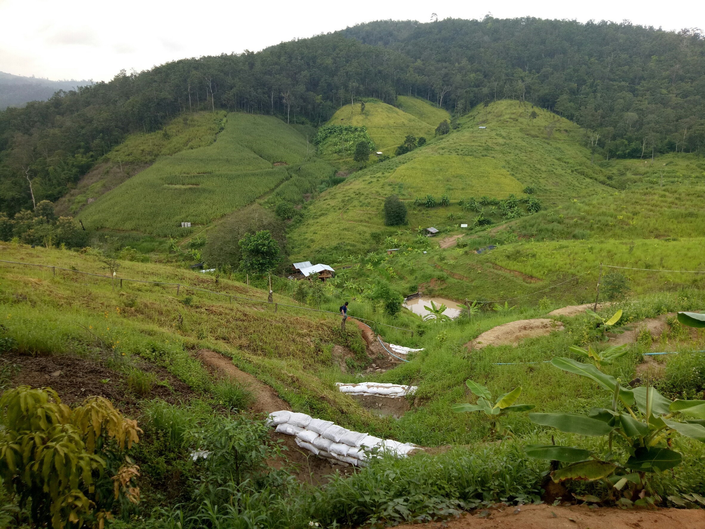
The "Khok-Nong-Na" model takes account of the geology, topography, and social and economic aspects of the area. The officers of the Foundation train the villagers to understand the concept of the "Khok-Nong-Na" model, under which the farm area is divided into 30:30:30:10. Thus 30% is for water resources (ponds and water channels), 30% for paddy rice, 30% for the upland (mound) area with forest or economic trees and 10% for settlements and animal husbandry. The application of the Khok-Nong-Na model is designed to restore and rehabilitate the deforested mountainous zone. The topography of the area is an important factor in selecting a suitable location for the mound, the reservoir and the paddy field, as follows:
1. Upland or Mound (Khok) is the slope where "three kinds of trees” are cultivated: with the slogan "three forests, four benefits". The four benefits are consumption, construction and economy, while preserving the ecosystem.
2. Reservoir (Nong), the lowland area is dedicated to water resources, including the checkdam or weir, the sediment trap, the water channel and the pond, for both consumption and agricultural use. The checkdam or weir in the upper area serves as storage and to control the flow of water. The water channel is designed to deliver water to the pond or reservoir in the lower area.
3. Paddy field (Na) is important because rice is the main staple for Thai people. Rice terraces are used on slopes, with paddy fields in the lowland. The main purpose of rice production is for home consumption as well as income. The ridge surrounding rice terraces should be high and wide to hold enough water.
Water storage in this area is modified by retaining water in the upstream and setting up checkdams to increase water level in front of each checkdam. There should be several dams depending on the length and slope of the water channel. Some water is stored in the soil profile in the forest as well as in the area under trees as a source of underground and absorbed water. Soil management is integrated in conservation and improvement; terraces with vetiver grass planted along the contour line prevent soil erosion on the steep slopes where rice is produced. Soil rehabilitation starts with use of organic fertilizers, which release plant nutrients and increase soil microbial activities. The native rice variety is grown: rich soil reduces the risk of diseases and insect pests. Proper management of the water level in the paddy field can control weeds, accelerate plant growth and crop yield. Around this area edible crops and vegetables can be grown, as well as the establishment of small livestock and fish farms.
2.3 Photos of the Technology
Media Gallery

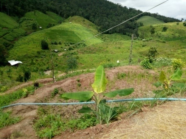
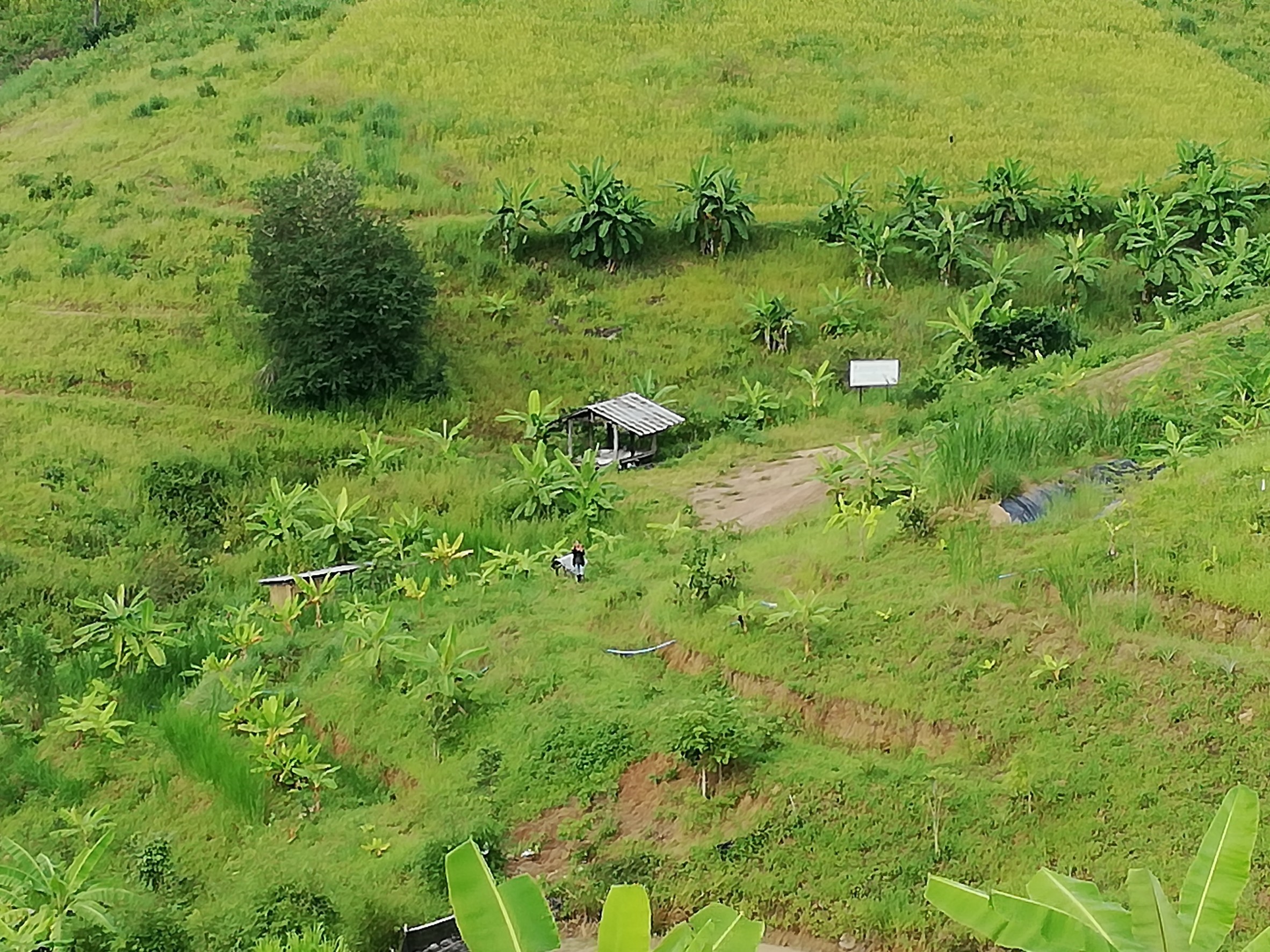
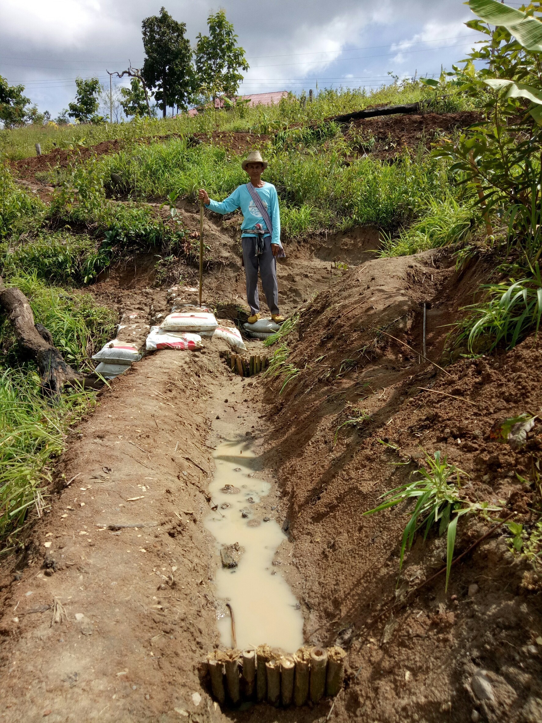
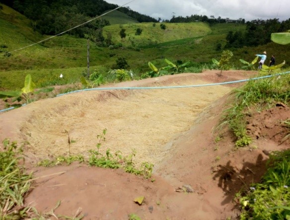
General remarks regarding photos:
Vetiver grass is planted along contour line on the slope and terraced area. Food crops, vegetables and bananas are planted on the ridge of the terrace. Check dams, drainage canals and ponds are set up, fruit trees and native trees are planted in upper part of the area.
2.4 Videos of the Technology
Date:
12/09/2018
Location:
Ban Thap Sub-district, Mae Chaem District, Chiang Mai Province, 50270
Name of videographer:
Ms.Tanomkwan Tipvong
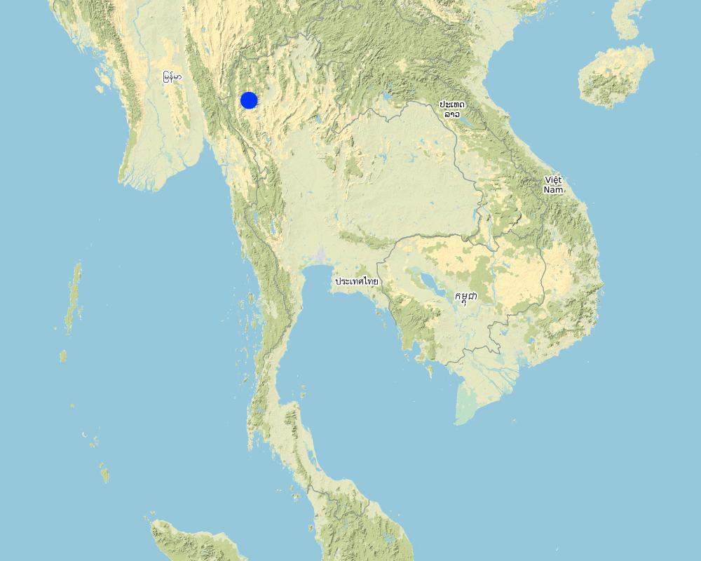
2.5 Country/ region/ locations where the Technology has been applied and which are covered by this assessment
Country:
Thailand
Region/ State/ Province:
Chiang Mai Province
Further specification of location:
Ban Thap Sub-district, Mae Chaem District, Chiang Mai Province, 50270
Comments:
This project is in the land degraded area by deforestation in the Northern Thailand.
Map
×2.6 Date of implementation
Indicate year of implementation:
2006
If precise year is not known, indicate approximate date:
- 10-50 years ago
2.7 Introduction of the Technology
Specify how the Technology was introduced:
- through projects/ external interventions
Comments (type of project, etc.):
The integrated land management of Khok-Nong-Na model can help to solve drought problems, and by mulching with rice straw it also reduces smoke from burning rice and corn residues.
3. Classification of the SLM Technology
3.1 Main purpose(s) of the Technology
- reduce, prevent, restore land degradation
- conserve ecosystem
- reduce risk of disasters
- create beneficial economic impact
3.2 Current land use type(s) where the Technology is applied

Mixed (crops/ grazing/ trees), incl. agroforestry
- Agro-silvopastoralism
Main products/ services:
Main products are trees for natural conservation such as Afzelia wood, Champaca, Siamese Rosewood, Yangna with various fruit trees for income and consumption such as banana, longan, tamarind, rambutan, mangosteen and bamboo, and rice as an economic crop for sale (as well as consumption).

Waterways, waterbodies, wetlands
- Drainage lines, waterways
- Ponds, dams
- Swamps, wetlands
- water storage tank
Main products/ services:
Several kinds of water storage and drainage system are integrated for the maximum utilization of water in the area.
If land use has changed due to the implementation of the Technology, indicate land use before implementation of the Technology:
Annual cropping
3.3 Further information about land use
Water supply for the land on which the Technology is applied:
- rainfed
Comments:
-
Number of growing seasons per year:
- 1
Specify:
Rainfed of paddy rice and fruit trees
Livestock density (if relevant):
This farm had 8 cattle and they had Napier grass planted near the stream for cattle feed.
3.4 SLM group to which the Technology belongs
- agroforestry
- water harvesting
- irrigation management (incl. water supply, drainage)
3.5 Spread of the Technology
Specify the spread of the Technology:
- evenly spread over an area
If the Technology is evenly spread over an area, indicate approximate area covered:
- > 10,000 km2
Comments:
More than the area of Mae Chaem district (around 2,685,000 square kilometers)
3.6 SLM measures comprising the Technology

agronomic measures
- A1: Vegetation/ soil cover

vegetative measures
- V2: Grasses and perennial herbaceous plants

structural measures
- S1: Terraces
- S3: Graded ditches, channels, waterways
- S4: Level ditches, pits
3.7 Main types of land degradation addressed by the Technology

chemical soil deterioration
- Cn: fertility decline and reduced organic matter content (not caused by erosion)
- Cp: soil pollution
Comments:
Land degradation has been accelerated by human interference such as application of pesticides, fungicides and herbicides in sloping areas.
3.8 Prevention, reduction, or restoration of land degradation
Specify the goal of the Technology with regard to land degradation:
- reduce land degradation
- restore/ rehabilitate severely degraded land
4. Technical specifications, implementation activities, inputs, and costs
4.1 Technical drawing of the Technology
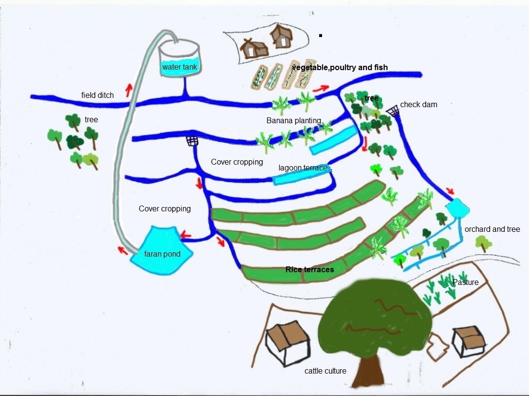
Author:
Ms.Somjit Lertdisayawan
Date:
12/09/2018
4.2 Technical specifications/ explanations of technical drawing
The central and most economically important part of the Khok-Nong-Na model is the reservoir or pond, which is 3m wide, 20m long and 3m deep in the lowland. Dimension of the pond at the first stage of digging is 1m wide, 20m long and 0.7m deep. Install the 20cu m water storage tank at the top of the slope; pump the water from the pond to the storage tank by using a solar pump. The land user releases water from the tank by using a small channel (0.2-0.5m wide) to the forest and fruit trees area, as well as to the paddy rice fields, vegetables and several kinds of economic crops. In this case there are six checkdams located along the water channel. These checkdams decrease the flow rate and store water in front of each dam, with a 0.3m height of water level, sufficient to grow rice once a year. On the ridge bank of the channel the land user grows vetiver grass, banana, vegetables, and some edible crops. Some part of the area is being reforested, with fruit trees mixed with wood trees. Mulching the soil with crop residues or grass can prevent the soil from direct sunlight, thus maintaining suitable soil moisture.
4.3 General information regarding the calculation of inputs and costs
Specify how costs and inputs were calculated:
- per Technology area
Indicate size and area unit:
25 Rai
If using a local area unit, indicate conversion factor to one hectare:
6.25 Rai
other/ national currency (specify):
Baht (THB)
Indicate exchange rate from USD to local currency (if relevant): 1 USD =:
32.0
Indicate average wage cost of hired labour per day:
300 THB
4.4 Establishment activities
| Activity | Type of measure | Timing | |
|---|---|---|---|
| 1. | prepare reservoir, terrace and conservation measures | Structural | |
| 2. | prepare drainage canal | Structural | |
| 3. | vetiver and cover crops plantation | Vegetative | |
| 4. | vegetables, wood trees and fruit trees plantation | Agronomic | |
| 5. | prepare check dam | Structural | |
| 6. | prepare water storage tank | Structural |
4.5 Costs and inputs needed for establishment
| Specify input | Unit | Quantity | Costs per Unit | Total costs per input | % of costs borne by land users | |
|---|---|---|---|---|---|---|
| Labour | Labour for main structure (5mx4d) | person/day | 20.0 | 300.0 | 6000.0 | |
| Equipment | Tractor hired (including fuel) | day | 4.0 | 5450.0 | 21800.0 | 100.0 |
| Plant material | supported by government sector | - | ||||
| Construction material | Check dam (100 bags/dam) | bag | 600.0 | 4.0 | 2400.0 | |
| Construction material | Labour for this activity | person/day | 42.0 | 300.0 | 12600.0 | |
| Other | Tank for water storage (20,000 liter) | tank | 1.0 | 8600.0 | 8600.0 | 100.0 |
| Other | Labour of construct and install tank | person/day | 147.0 | 300.0 | 44100.0 | |
| Total costs for establishment of the Technology | 95500.0 | |||||
If land user bore less than 100% of costs, indicate who covered the remaining costs:
least than 10%, where Royal forest Project supported more than 90%
Comments:
-
4.6 Maintenance/ recurrent activities
Comments:
It is the beginning of the model establishment, which land users maintained this area and all labor were rotation of the people from the project.
4.7 Costs and inputs needed for maintenance/ recurrent activities (per year)
If land user bore less than 100% of costs, indicate who covered the remaining costs:
-
Comments:
-
4.8 Most important factors affecting the costs
Describe the most determinate factors affecting the costs:
-
5. Natural and human environment
5.1 Climate
Annual rainfall
- < 250 mm
- 251-500 mm
- 501-750 mm
- 751-1,000 mm
- 1,001-1,500 mm
- 1,501-2,000 mm
- 2,001-3,000 mm
- 3,001-4,000 mm
- > 4,000 mm
Specify average annual rainfall (if known), in mm:
1370.00
Specifications/ comments on rainfall:
The serious drought period is during March and April
Indicate the name of the reference meteorological station considered:
-
Agro-climatic zone
- sub-humid
-
5.2 Topography
Slopes on average:
- flat (0-2%)
- gentle (3-5%)
- moderate (6-10%)
- rolling (11-15%)
- hilly (16-30%)
- steep (31-60%)
- very steep (>60%)
Landforms:
- plateau/plains
- ridges
- mountain slopes
- hill slopes
- footslopes
- valley floors
Altitudinal zone:
- 0-100 m a.s.l.
- 101-500 m a.s.l.
- 501-1,000 m a.s.l.
- 1,001-1,500 m a.s.l.
- 1,501-2,000 m a.s.l.
- 2,001-2,500 m a.s.l.
- 2,501-3,000 m a.s.l.
- 3,001-4,000 m a.s.l.
- > 4,000 m a.s.l.
5.3 Soils
Soil depth on average:
- very shallow (0-20 cm)
- shallow (21-50 cm)
- moderately deep (51-80 cm)
- deep (81-120 cm)
- very deep (> 120 cm)
Soil texture (topsoil):
- medium (loamy, silty)
Soil texture (> 20 cm below surface):
- medium (loamy, silty)
Topsoil organic matter:
- low (<1%)
If available, attach full soil description or specify the available information, e.g. soil type, soil PH/ acidity, Cation Exchange Capacity, nitrogen, salinity etc.
-
5.4 Water availability and quality
Ground water table:
5-50 m
Availability of surface water:
medium
Water quality (untreated):
for agricultural use only (irrigation)
Is water salinity a problem?
No
Is flooding of the area occurring?
No
Comments and further specifications on water quality and quantity:
Generally, land users in upstream of the watershed area cultivated cabbage, maize or red onion. They used chemical fertilizers, insecticides and herbicides in this area, where some areas faced problem about contaminated water especially in the off-site area.
5.5 Biodiversity
Species diversity:
- medium
Habitat diversity:
- medium
Comments and further specifications on biodiversity:
-
5.6 Characteristics of land users applying the Technology
Sedentary or nomadic:
- Sedentary
Market orientation of production system:
- subsistence (self-supply)
Off-farm income:
- > 50% of all income
Relative level of wealth:
- poor
- average
Individuals or groups:
- individual/ household
- groups/ community
Level of mechanization:
- manual work
Gender:
- women
- men
Age of land users:
- middle-aged
- elderly
Indicate other relevant characteristics of the land users:
Some land users have individual debts of nearly a hundred thousand Baht and they need to pay back to their creditor, and also to restore and conserve the forest and ecosystem services. Moreover, they need better natural resources and environment for their children to live in the future. For working in the field, land users are divided into 4 groups, with 5-6 people in each group and rotating to work for each other 2 days a week.
5.7 Average area of land owned or leased by land users applying the Technology
- < 0.5 ha
- 0.5-1 ha
- 1-2 ha
- 2-5 ha
- 5-15 ha
- 15-50 ha
- 50-100 ha
- 100-500 ha
- 500-1,000 ha
- 1,000-10,000 ha
- > 10,000 ha
Is this considered small-, medium- or large-scale (referring to local context)?
- large-scale
Comments:
-
5.8 Land ownership, land use rights, and water use rights
Land ownership:
- individual, not titled
Land use rights:
- open access (unorganized)
- communal (organized)
Water use rights:
- open access (unorganized)
- communal (organized)
Comments:
-
5.9 Access to services and infrastructure
health:
- poor
- moderate
- good
education:
- poor
- moderate
- good
technical assistance:
- poor
- moderate
- good
employment (e.g. off-farm):
- poor
- moderate
- good
markets:
- poor
- moderate
- good
energy:
- poor
- moderate
- good
roads and transport:
- poor
- moderate
- good
drinking water and sanitation:
- poor
- moderate
- good
financial services:
- poor
- moderate
- good
6. Impacts and concluding statements
6.1 On-site impacts the Technology has shown
Socio-economic impacts
Water availability and quality
irrigation water availability
irrigation water quality
Income and costs
expenses on agricultural inputs
farm income
workload
Socio-cultural impacts
food security/ self-sufficiency
land use/ water rights
Ecological impacts
Water cycle/ runoff
water quantity
water quality
Soil
soil moisture
soil cover
soil compaction
soil organic matter/ below ground C
Biodiversity: vegetation, animals
Vegetation cover
biomass/ above ground C
beneficial species
pest/ disease control
Climate and disaster risk reduction
drought impacts
fire risk
6.2 Off-site impacts the Technology has shown
downstream siltation
groundwater/ river pollution
6.3 Exposure and sensitivity of the Technology to gradual climate change and climate-related extremes/ disasters (as perceived by land users)
Climate-related extremes (disasters)
Climatological disasters
| How does the Technology cope with it? | |
|---|---|
| drought | well |
Comments:
-
6.4 Cost-benefit analysis
How do the benefits compare with the establishment costs (from land users’ perspective)?
Short-term returns:
neutral/ balanced
Long-term returns:
very positive
Comments:
-
6.5 Adoption of the Technology
- 10-50%
If available, quantify (no. of households and/ or area covered):
21
Of all those who have adopted the Technology, how many have did so spontaneously, i.e. without receiving any material incentives/ payments?
- 0-10%
Comments:
At the beginning totally were 32 households, and 19 households went back to cultivate corn as in the past, that is only 13 households were still in this project. because they did not sure clearly about official support. But now 9 households turned back to the project due to their debt so totally were 21 households.
6.6 Adaptation
Has the Technology been modified recently to adapt to changing conditions?
No
6.7 Strengths/ advantages/ opportunities of the Technology
| Strengths/ advantages/ opportunities in the land user’s view |
|---|
| Soil and water resources are improved, and soil fertility/soil quality is better. Soil management and preparation is easy, crop growth is better than before, so the yields of each crop and rice are improved. |
| The model emphasizes in natural and organic agriculture. |
| Expecting the health of land users will be better, with clean and safe food produced by this project. |
| Land user community is a very strong network with high unity. They set up the labour-sharing system and rotate the members to work in land users' fields. They have their own regulations and strict implementing disciplines. |
| Strengths/ advantages/ opportunities in the compiler’s or other key resource person’s view |
|---|
| The land user community is so strong in restoration and conservation of their area, which they set up the labour-sharing system in farm management and also construct the conservation measures in the area. |
| The concept of the project is sustainable approach in self sufficiency economy, which they can be self-reliant on their farm products. |
| The project has 4 main components that occupy following percentages of total land: forest/fruit trees, 30%; reservoir/water storage, 30%; rice production, 30% and settlement, 10%. That is the concept of the self-sufficiency economy. |
6.8 Weaknesses/ disadvantages/ risks of the Technology and ways of overcoming them
| Weaknesses/ disadvantages/ risks in the land user’s view | How can they be overcome? |
|---|---|
| Land users must have more work to do in their land because they cultivated several kinds of vegetables, crops, fish and some livestock. | They set the labour-sharing system and rotate the members to work in land users’ fields. |
| Land users still have different idea in detail to manage their land. | The community needs to have regulations. |
| At present, they don't have noticeably more income, but they have abundant food for family consumption, and the rest will be sold at the local market. | It needs more time for some crops to produce more yields. |
| Land users do not have their own land. | They need the government to solve their debt problem, and they are all willing to restore and conserve the forest area. |
| They need to have some income for reforestation by Carbon Credit process. | Now they have more income from local textile project of the housewives community. |
| Weaknesses/ disadvantages/ risks in the compiler’s or other key resource person’s view | How can they be overcome? |
|---|---|
| It needs time to strengthening the community network. | Now, according to the policy of the Ministry of Agriculture and Cooperatives, it wants to promote and enhance this model because it integrated soil and water management in the concept of the self-sufficiency economy. |
| Land users do not have their own land. It is necessary to put this problem up at the national level. | it is necessary to solve this problem in national level as government policy. |
| Some land users still need to understand more clearly about this project, and transfer this integrated technology directly to local Headman, leader of land users and also land users themselves. | Government sector will support land users to set up the basic facility and structure of their landscapes to fullfill the concept of Khok-Nong-Na model. |
7. References and links
7.1 Methods/ sources of information
- interviews with land users
2 persons
- compilation from reports and other existing documentation
3 persons
7.3 Links to relevant information which is available online
Title/ description:
People Changes the World SS4 TAPE 28: Mae Chaem Model Plus (9 July 18) 1/3
URL:
https://www.youtube.com/watch?v=k7Bex9ku_qY&feature=youtu.be
Title/ description:
People Changes the World SS4 TAPE 28: Mae Chaem Model Plus (9 July 18) 2/3
URL:
https://www.youtube.com/watch?v=RwY01nOLVvs&feature=youtu.be
Title/ description:
People Changes the World SS4 TAPE 28: Mae Chaem Model Plus (9 July 18) 3/3
URL:
https://www.youtube.com/watch?v=doiZ8r6Bo9I&feature=youtu.be
Title/ description:
3D Topography of Ban Song Tarn, Mae Chaem District.
URL:
https://www.youtube.com/watch?v=_36pheU-GtU&feature=youtu.be
Title/ description:
3D Ban Song Tarn, Mae Chaem District
URL:
https://www.youtube.com/watch?v=xe6nY7iA0Ac&feature=youtu.be
Links and modules
Expand all Collapse allLinks
No links
Modules
No modules