Prevention of riverbank erosion by combination of green and grey measures [Tajikistan]
- Creation:
- Update:
- Compiler: Stefan Michel
- Editor: –
- Reviewer: Umed Vahobov
Защита берега реки путем комбинации строений и посадок
technologies_4311 - Tajikistan
View sections
Expand all Collapse all1. General information
1.2 Contact details of resource persons and institutions involved in the assessment and documentation of the Technology
Key resource person(s)
SLM specialist:
Nodir Muhidinov
Deutsche Gesellschaft für Internationale Zusammenarbeit (GIZ)
Tajikistan
Name of project which facilitated the documentation/ evaluation of the Technology (if relevant)
Strengthening of Livelihoods through Climate Change Adaptation in Kyrgyzstan and TajikistanName of the institution(s) which facilitated the documentation/ evaluation of the Technology (if relevant)
Deutsche Gesellschaft für Internationale Zusammenarbeit - Tajikistan (GIZ Tajikistan) - Tajikistan1.3 Conditions regarding the use of data documented through WOCAT
The compiler and key resource person(s) accept the conditions regarding the use of data documented through WOCAT:
Yes
1.4 Declaration on sustainability of the described Technology
Is the Technology described here problematic with regard to land degradation, so that it cannot be declared a sustainable land management technology?
No
1.5 Reference to Questionnaire(s) on SLM Approaches (documented using WOCAT)
Integrated disaster risk reduction in flood-affected areas by … [Tajikistan]
Climate change and land degradation in upper catchment areas cause an increasing frequency and intensity of flash flood and debris flows affecting settlements and productive areas. GIZ in collaboration with the Committee on Emergency Situations assisted local communities in the implementation of integrated preventive measures.
- Compiler: Stefan Michel
2. Description of the SLM Technology
2.1 Short description of the Technology
Definition of the Technology:
Flashfloods in riverbeds cause intensive riverbank erosion, which threatens villages, infrastructure and productive lands. Preventive measures combining "grey" (physical structures) and "green" (living trees) elements are more effective, sustainable and cost efficient than constructive measures only.
2.2 Detailed description of the Technology
Description:
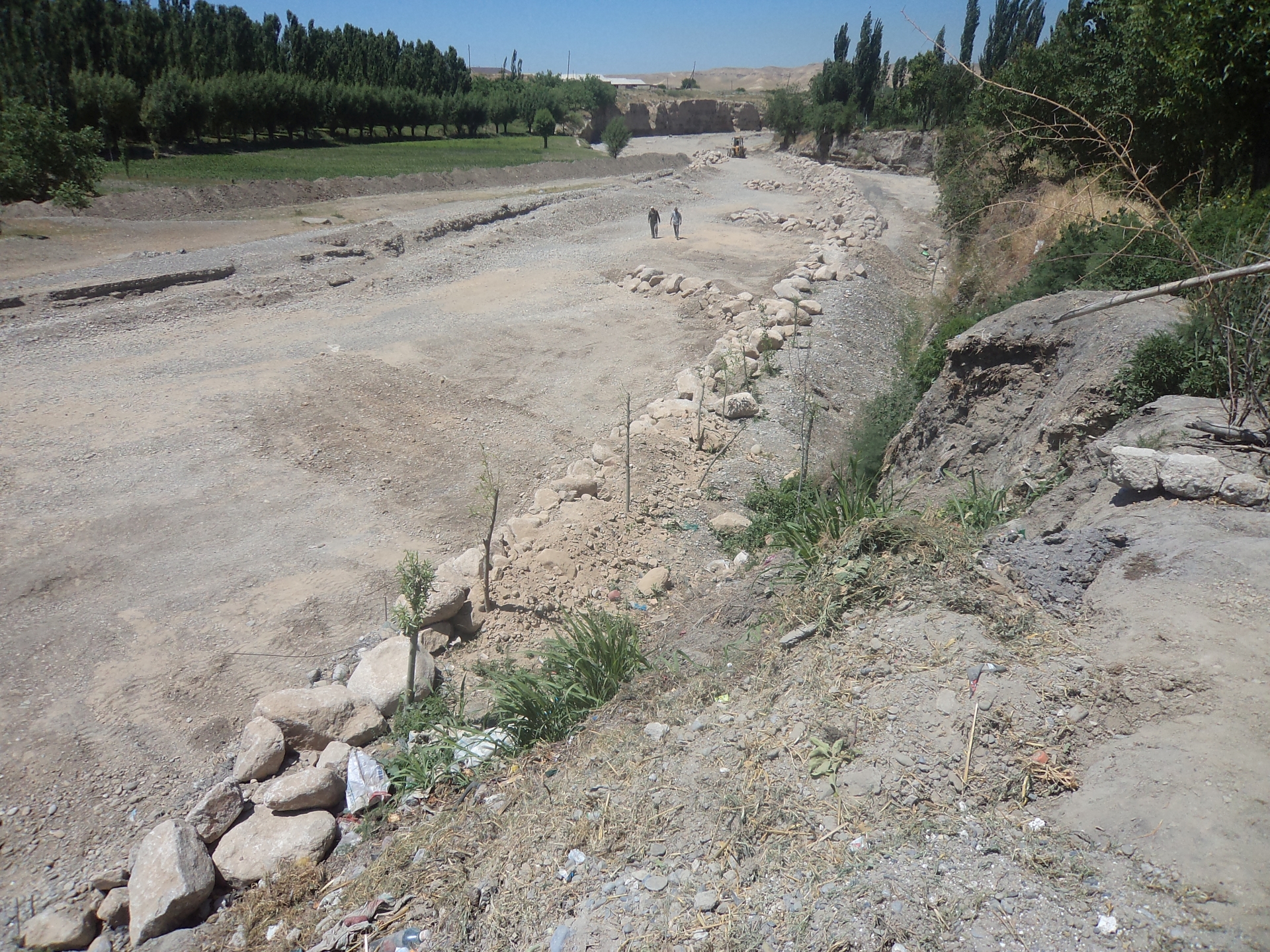
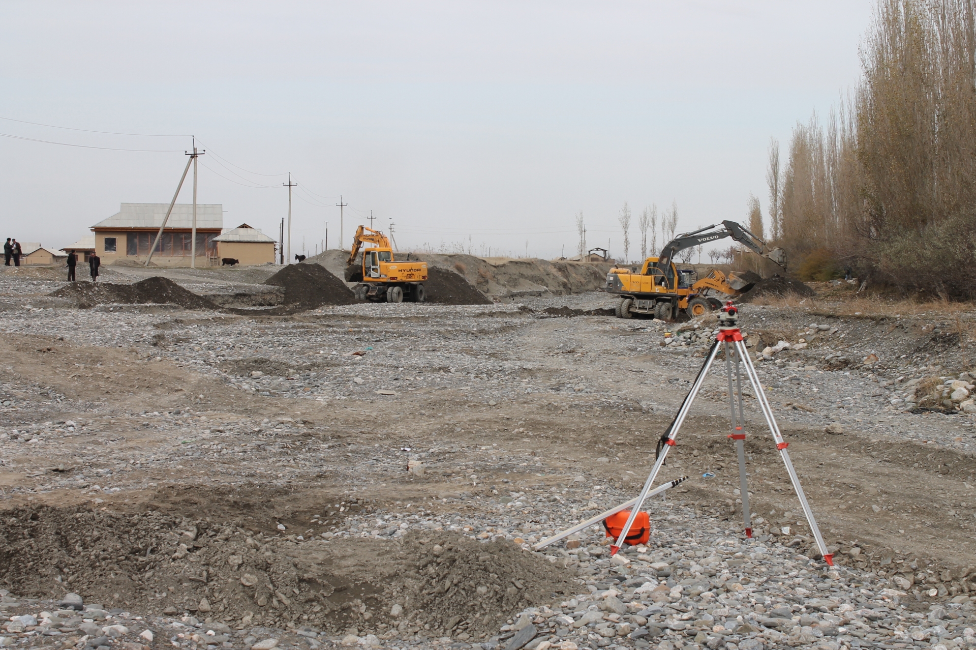
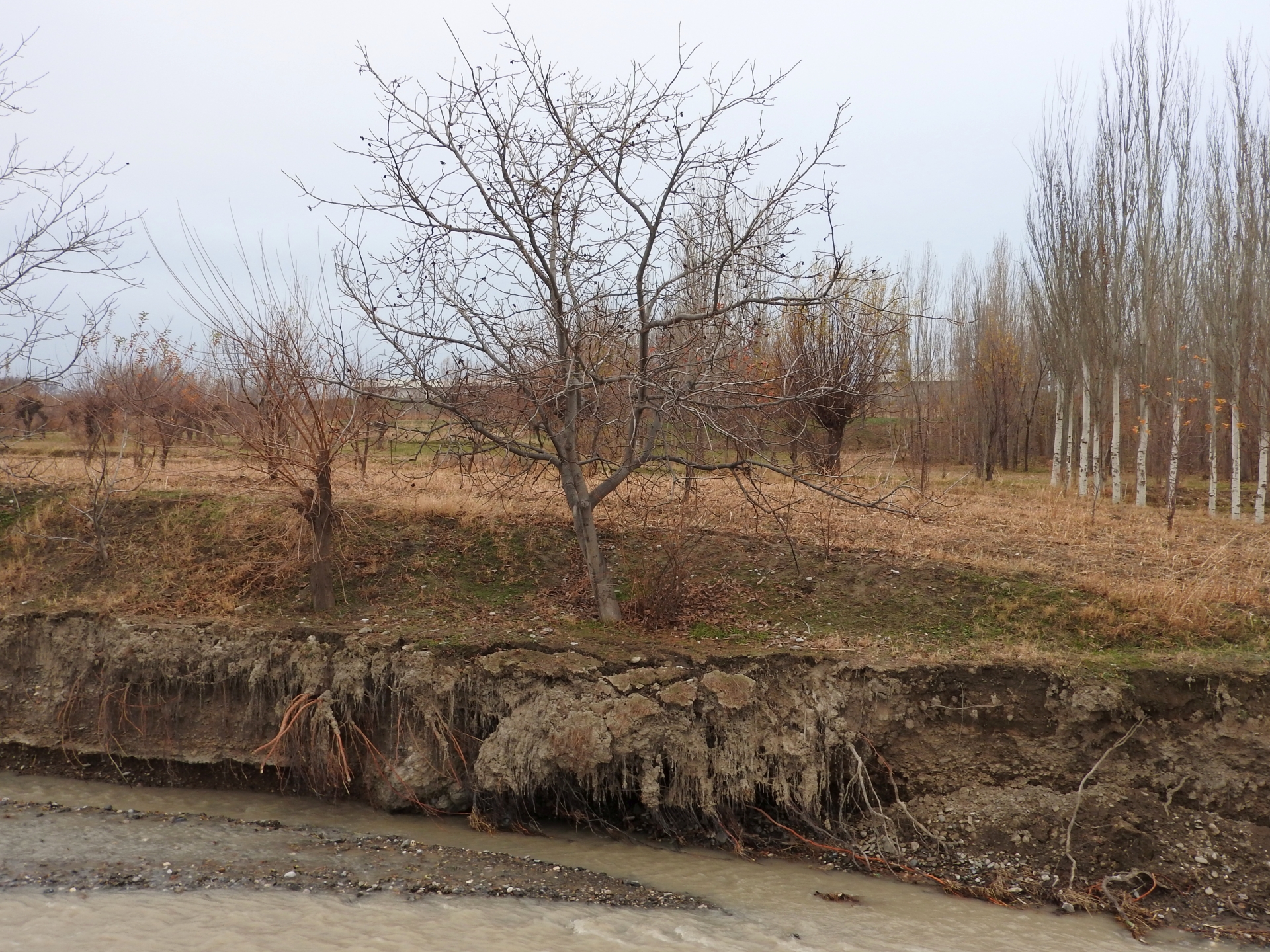
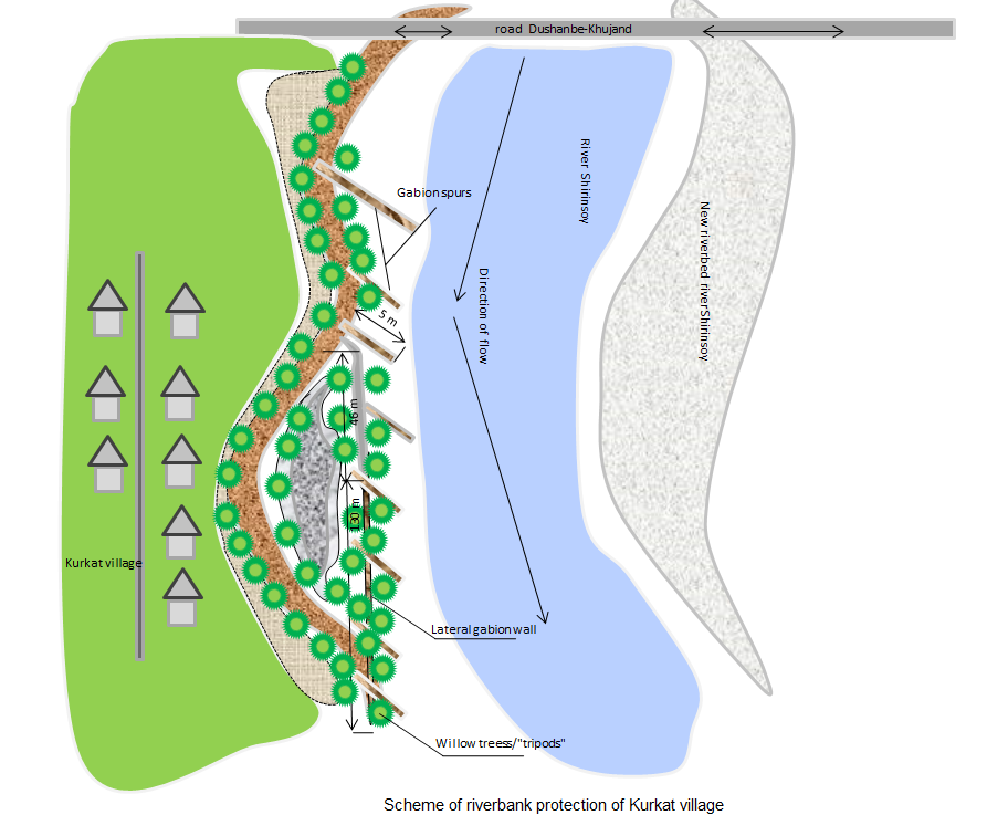
Villages at the northern slopes of the Turkestan range in Sughd region are often located at riverbanks. The amounts of water flowing in the river channels naturally varies much during the year. After intensive rainfall or snowmelt the water flow can suddenly increase manifold. These flashfloods carry huge amounts of debris and are therefore even more destructive. The combined effects of degradation of woodlands and rangelands in the upper catchments and the impact of climate change with accelerated snowmelt and higher frequency and intensity of heavy rainfall events have increased the risks of these debris flows. In several villages of Sughd region, especially in Spitamen and Devashtich districts, riverbank erosion during flashflood and debris flows increasingly threatened houses, infrastructure and productive lands.
GIZ in collaboration with the local branches of the Committee for Emergency Situations, district and sub-district authorities assisted local community in the implementation of riverbank protection measures. The design of the protective structure was specifically adapted to the local situation. For achieving immediately reliable protection structural measures (“grey”) included:
•Modification of river channels with excavators and bulldozers to redirect flows;
•Erection of dykes and spurs from large rocks along erosion prone riverbanks;
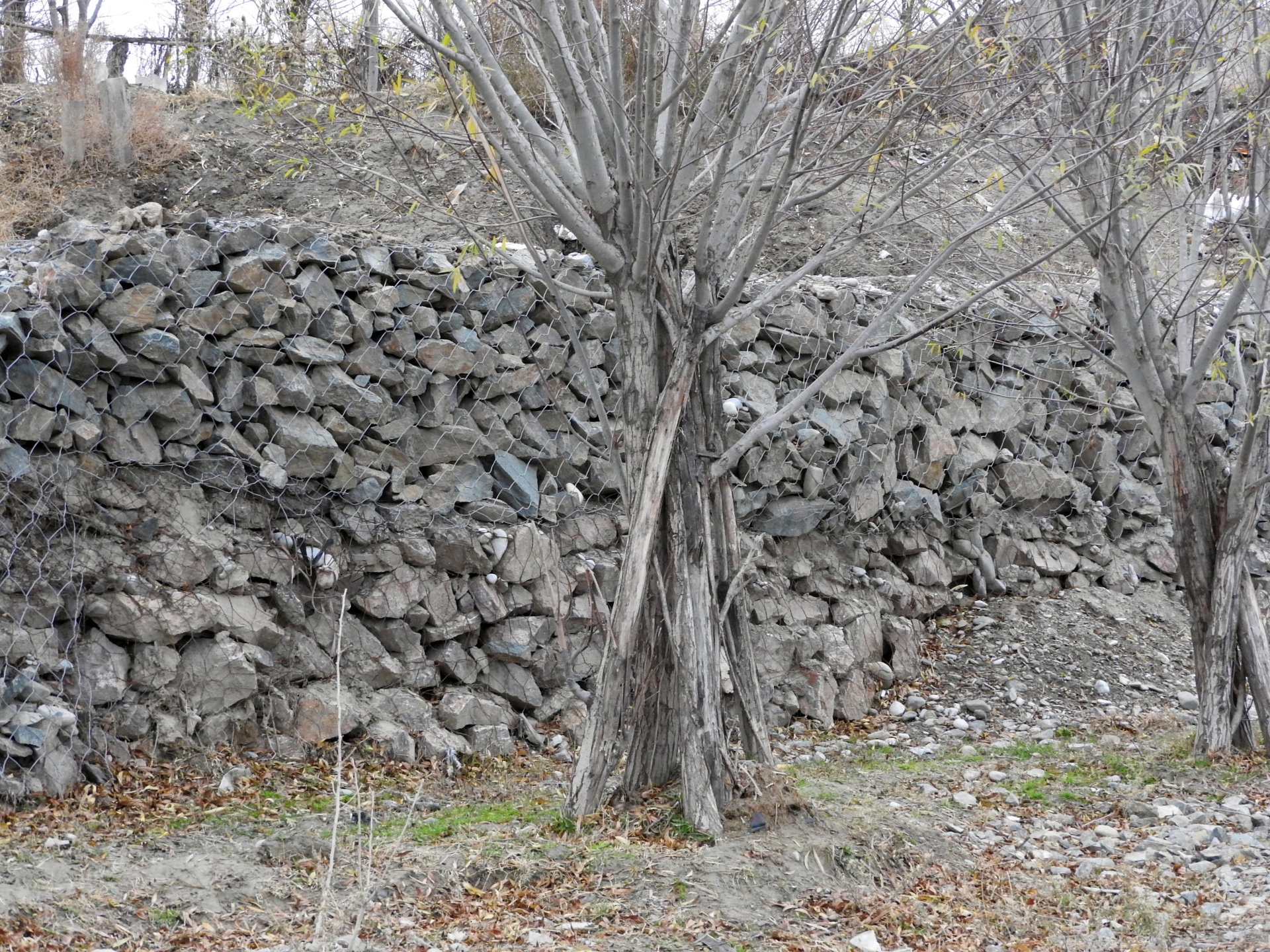
•Erection of lateral gabion walls along erosion prone riverbanks;
•Erection of gabion spurs, which concentrate the water flow in the center of the river channel and thus reduce the force of water and debris on riverbanks and lateral gabion walls.
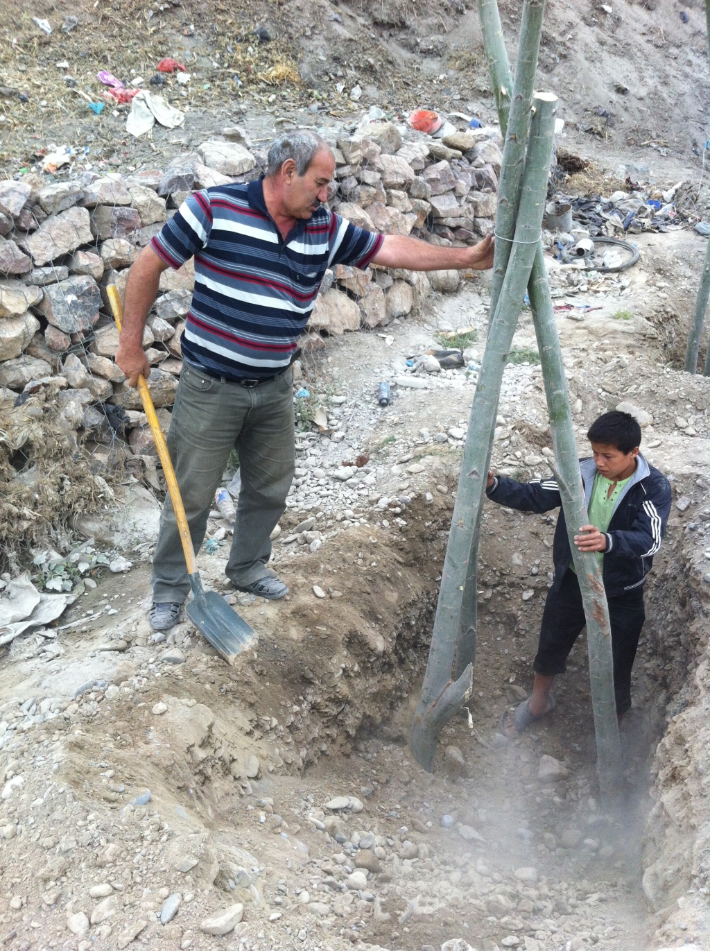
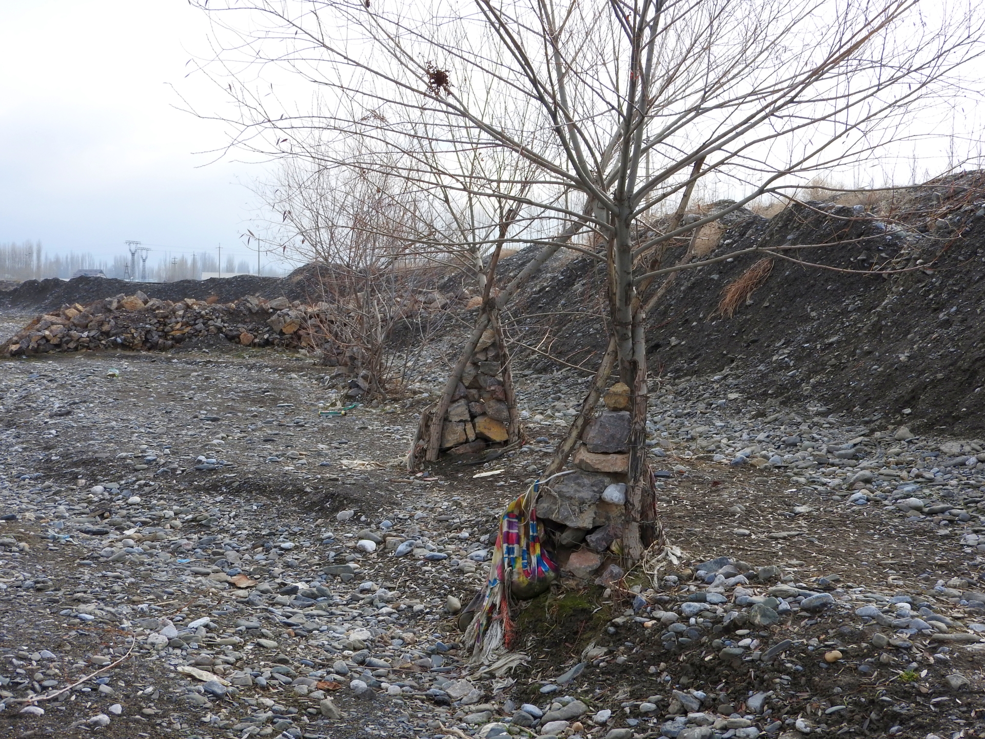
In the long run “grey” measures tend to be damaged by flashfloods and debris flows. “Green” measures can enforce the protective structures and thus increase the sustainability, effectiveness and cost efficiency of structural measures. Willows are particularly suitable for erosion prevention in river channels as they grow fast, establish a large fixing root system in the riverbed, their wood is flexible and withstands intensive force and they well regenerate after damage. “Green” measures for reinforcing riverbank protection included:
•Planting of single willow saplings in rows immediately behind stone dykes;
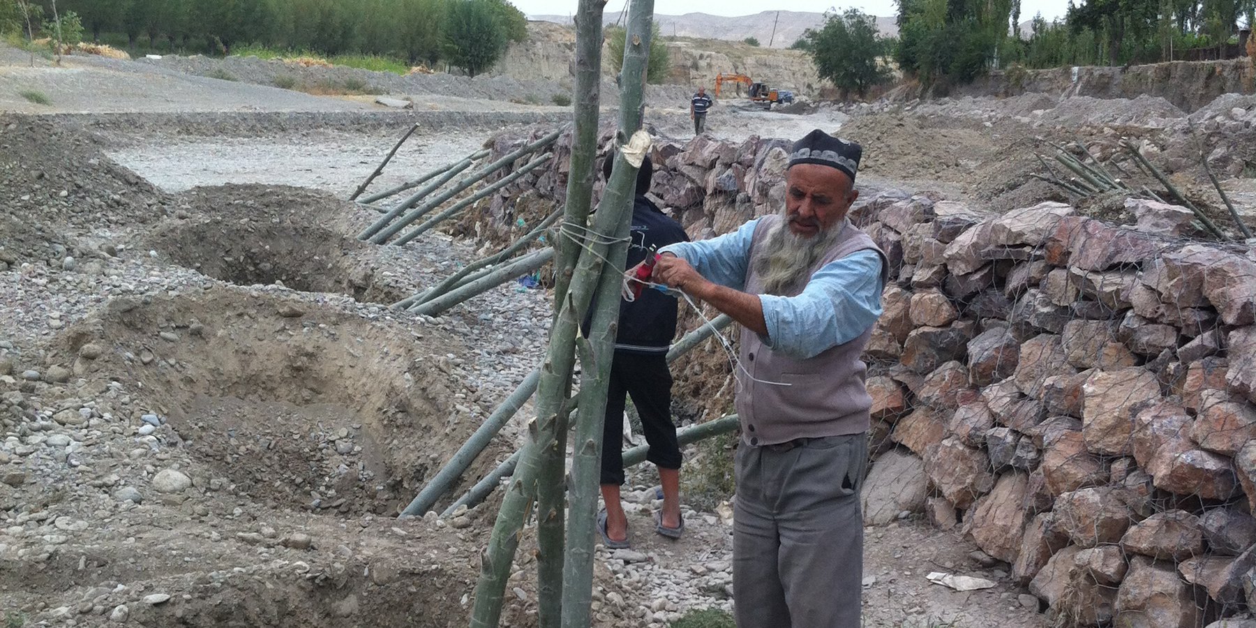
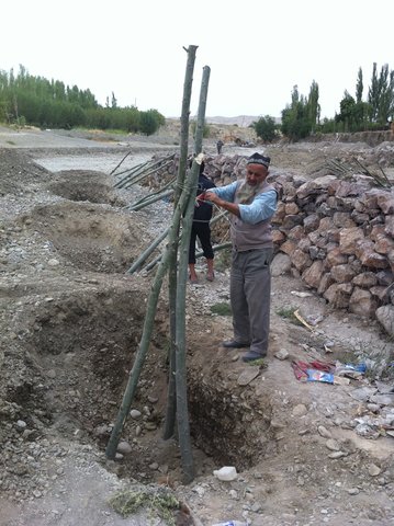
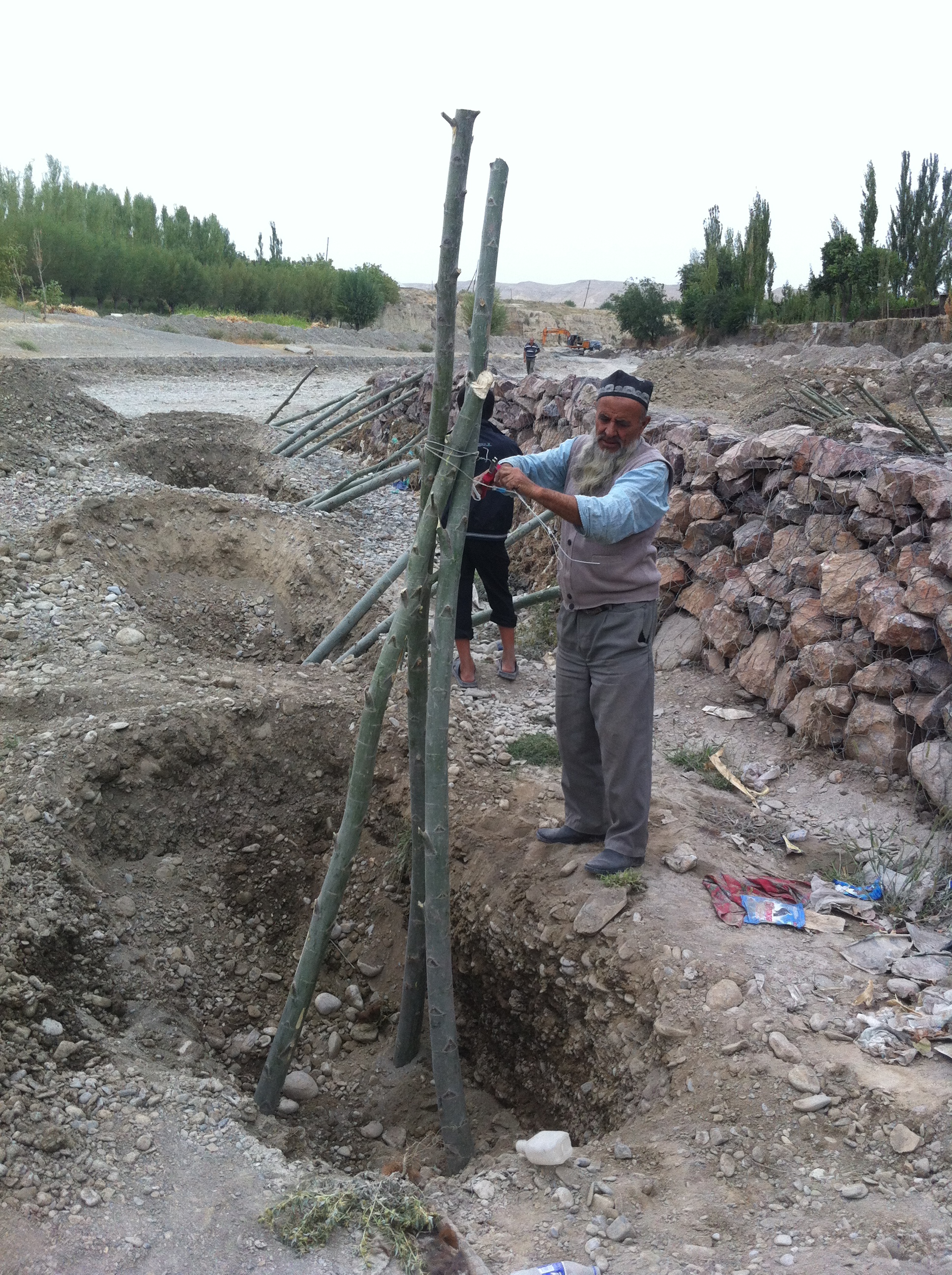
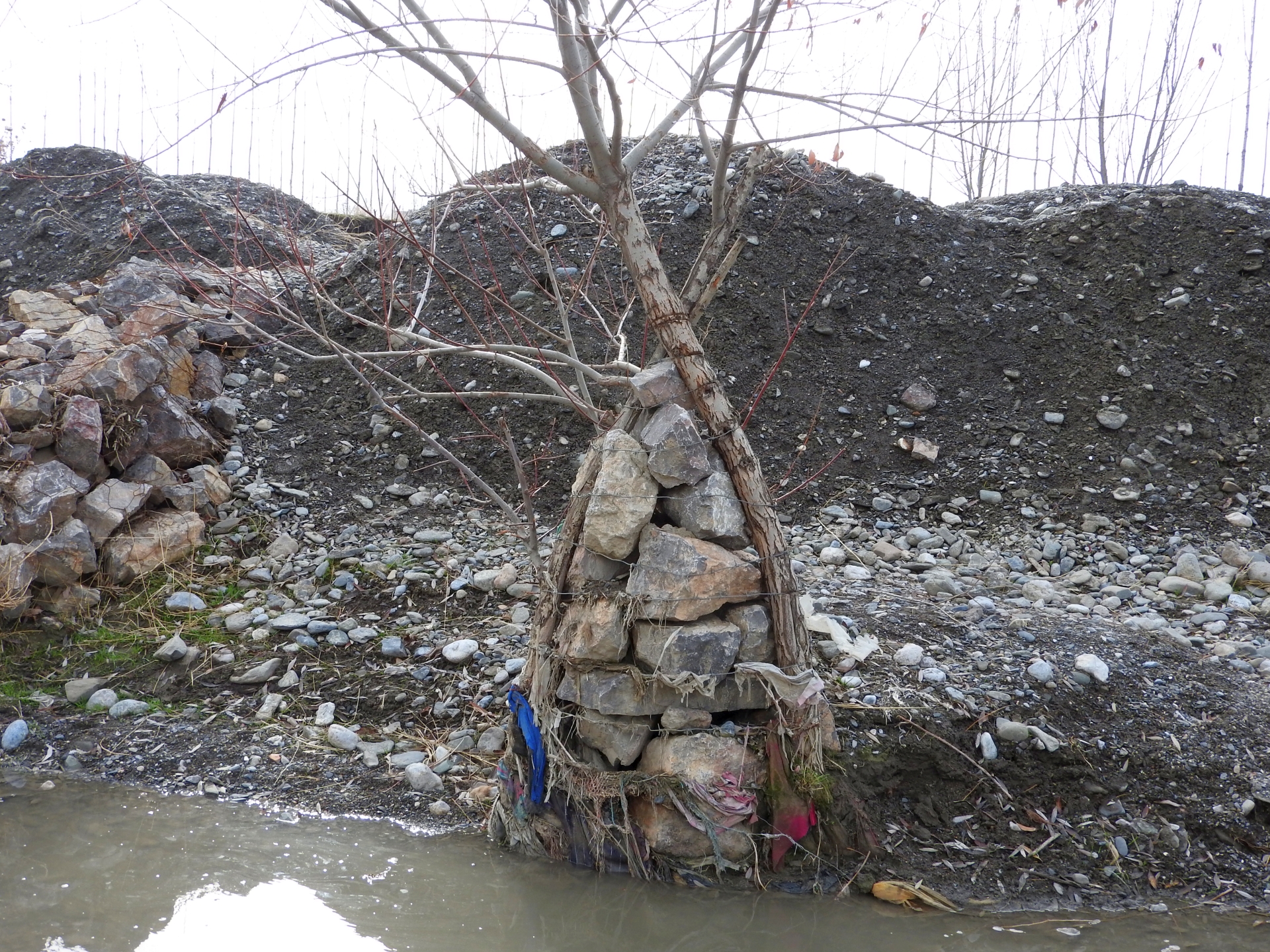
•Planting of willows in form of one or several rows of three seedlings per spot, connected with cords to “tripods” to increase stability;
•Planting of willows in form of one or several rows of three seedlings per spot, connected with cords to “tripods” around a small gabion, which additionally increases the resistance of the planted willows against the forces of water and debris.
The works have been overseen by the GIZ engineer, GIZ also covered expenses for gabion nets and machinery, while willow branches and labor were provided by the communities.
After up to five years the riverbank protection is still functional at all sites and prevented damage from floods to lives and property. No substantial damage occurred to the erected structures despite several heavy flashflood and debris flow events at all sites. Most planted willows established well, have substantially grown and provide an increasingly effective protection. In few spots willows dried up, where washed out or damaged by livestock and replanting would be necessary to maintain the effectiveness of the riverbank protection. In the future the willows can be used as coppice wood with their large branches cut, providing new planting material for additional “green” protection measures, for construction and as fuel. Additionally the willows contribute to the local biodiversity by providing habitat for birds and other animals, improve the microclimate and improve the view of the villages and the landscape. The multiple benefits from the “green” measures are expected to motivate care by the villagers, in particular prevention of damage caused by livestock and insufficient water supply and replanting of lost trees.
2.3 Photos of the Technology
Media Gallery
2.5 Country/ region/ locations where the Technology has been applied and which are covered by this assessment
Country:
Tajikistan
Region/ State/ Province:
Sughd region
Further specification of location:
Spitamen district, Devashtich district
Specify the spread of the Technology:
- applied at specific points/ concentrated on a small area
Is/are the technology site(s) located in a permanently protected area?
No
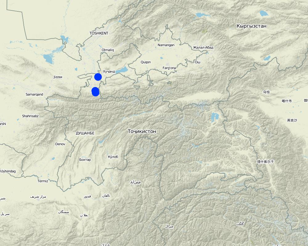
Map
×2.6 Date of implementation
Indicate year of implementation:
2013
If precise year is not known, indicate approximate date:
- less than 10 years ago (recently)
2.7 Introduction of the Technology
Specify how the Technology was introduced:
- through projects/ external interventions
- on request of local Committee for Emergency Situations
3. Classification of the SLM Technology
3.1 Main purpose(s) of the Technology
- reduce risk of disasters
- mitigate climate change and its impacts
- create beneficial social impact
3.2 Current land use type(s) where the Technology is applied

Forest/ woodlands
- Single trees, tree rows
- Salix spec.
Are the trees specified above deciduous or evergreen?
- deciduous
Products and services:
- Fuelwood
- Grazing/ browsing
- Nature conservation/ protection
- Recreation/ tourism
- Protection against natural hazards

Settlements, infrastructure
- Settlements, buildings
- Traffic: roads, railways

Waterways, waterbodies, wetlands
- Drainage lines, waterways
3.3 Has land use changed due to the implementation of the Technology?
Waterways, waterbodies, wetlands
- Drainage lines, waterways

Unproductive land
3.4 Water supply
Water supply for the land on which the Technology is applied:
- mixed rainfed-irrigated
Comments:
River channel with seasonal/episodical flow. Willows partly supported with improvised irrigation.
3.5 SLM group to which the Technology belongs
- ecosystem-based disaster risk reduction
3.6 SLM measures comprising the Technology

vegetative measures
- V1: Tree and shrub cover

structural measures
- S5: Dams, pans, ponds
- S11: Others
3.7 Main types of land degradation addressed by the Technology

soil erosion by water
- Wr: riverbank erosion
3.8 Prevention, reduction, or restoration of land degradation
Specify the goal of the Technology with regard to land degradation:
- prevent land degradation
- restore/ rehabilitate severely degraded land
4. Technical specifications, implementation activities, inputs, and costs
4.1 Technical drawing of the Technology
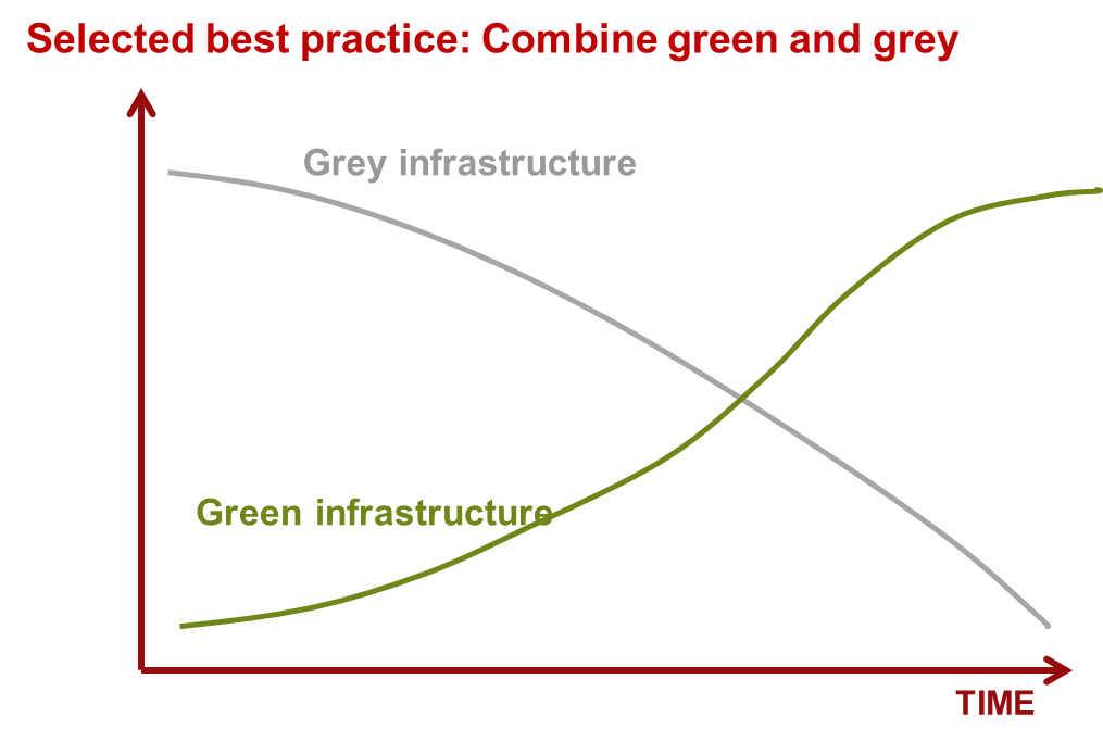
Technical specifications (related to technical drawing):
Scheme how over time "green" and "grey" measures are functional.
Author:
Nodir Muhidinov
Author:
Nodir Muhidinov, modified by Stefan Michel
Date:
11/01/2019
4.2 General information regarding the calculation of inputs and costs
other/ national currency (specify):
TJS
If relevant, indicate exchange rate from USD to local currency (e.g. 1 USD = 79.9 Brazilian Real): 1 USD =:
6.0
4.3 Establishment activities
| Activity | Timing (season) | |
|---|---|---|
| 1. | Modification of river channel | Fall |
| 2. | Erection of stone dykes and spurs | Fall |
| 3. | Building of gabions | Fall |
| 4. | Planting of willow trees, "tripods" | Fall |
4.4 Costs and inputs needed for establishment
| Specify input | Unit | Quantity | Costs per Unit | Total costs per input | % of costs borne by land users | |
|---|---|---|---|---|---|---|
| Labour | Construction of tripod from a willow tree and gabion net | pieces | 46.0 | |||
| Labour | Constrcution of gabion spurs | m³ | 381.0 | |||
| Labour | Laying down gabion net | m² | 812.4 | |||
| Equipment | Excavator | m³ | 1800.0 | |||
| Equipment | Buldozer | m³ | 7040.0 | |||
| Plant material | willow tree tripods | pieces | 46.0 | |||
| Construction material | Gabion net | m² | 812.4 | |||
| Construction material | Stones for gabions | m³ | 381.0 |
If you are unable to break down the costs in the table above, give an estimation of the total costs of establishing the Technology:
124690.0
If land user bore less than 100% of costs, indicate who covered the remaining costs:
GIZ: Transportation, procurement of materials (as specified) and lead worker fee: 87,940 TJS (13,224 EUR, 70 %); Community: Labour (manual works): 36,722 TJS (5,522 EUR; 30%)
Comments:
This is an example from one area in Devashtich district. The costs are varying and depend on the specific local circumstances. The addition of "green" measures increases the required labour, but does not substantially increase the overall costs.
4.5 Maintenance/ recurrent activities
| Activity | Timing/ frequency | |
|---|---|---|
| 1. | Prevention of damage to trees from livestock | Year round |
| 2. | Improvised irrigation | During seasons of low water availability at the planting sites |
| 3. | Closing of washed out places | After damage detected |
| 4. | Replanting | Fall |
4.6 Costs and inputs needed for maintenance/ recurrent activities (per year)
Comments:
Maintenance costs are low and can be covered by community contribution of labour.
5. Natural and human environment
5.1 Climate
Annual rainfall
- < 250 mm
- 251-500 mm
- 501-750 mm
- 751-1,000 mm
- 1,001-1,500 mm
- 1,501-2,000 mm
- 2,001-3,000 mm
- 3,001-4,000 mm
- > 4,000 mm
Specifications/ comments on rainfall:
Rainfall varies between the areas but of relevance is rainfall in the upper catchments, where no reference meteorolgical station exists.
Agro-climatic zone
- sub-humid
- semi-arid
The climate varies between the areas but of relevance is the climate and weather in the upper catchments.
5.2 Topography
Slopes on average:
- flat (0-2%)
- gentle (3-5%)
- moderate (6-10%)
- rolling (11-15%)
- hilly (16-30%)
- steep (31-60%)
- very steep (>60%)
Landforms:
- plateau/plains
- ridges
- mountain slopes
- hill slopes
- footslopes
- valley floors
Altitudinal zone:
- 0-100 m a.s.l.
- 101-500 m a.s.l.
- 501-1,000 m a.s.l.
- 1,001-1,500 m a.s.l.
- 1,501-2,000 m a.s.l.
- 2,001-2,500 m a.s.l.
- 2,501-3,000 m a.s.l.
- 3,001-4,000 m a.s.l.
- > 4,000 m a.s.l.
Indicate if the Technology is specifically applied in:
- concave situations
5.3 Soils
Soil depth on average:
- very shallow (0-20 cm)
- shallow (21-50 cm)
- moderately deep (51-80 cm)
- deep (81-120 cm)
- very deep (> 120 cm)
Soil texture (topsoil):
- coarse/ light (sandy)
Soil texture (> 20 cm below surface):
- coarse/ light (sandy)
Topsoil organic matter:
- low (<1%)
If available, attach full soil description or specify the available information, e.g. soil type, soil PH/ acidity, Cation Exchange Capacity, nitrogen, salinity etc.
Mainly gravel and sand in riverbeds.
5.4 Water availability and quality
Ground water table:
< 5 m
Availability of surface water:
good
Is water salinity a problem?
No
Is flooding of the area occurring?
Yes
Regularity:
episodically
5.5 Biodiversity
Species diversity:
- low
Habitat diversity:
- low
Comments and further specifications on biodiversity:
Planted trees increase the habitat for biodiversity.
5.6 Characteristics of land users applying the Technology
Sedentary or nomadic:
- Sedentary
- Semi-nomadic
Market orientation of production system:
- subsistence (self-supply)
- mixed (subsistence/ commercial)
Off-farm income:
- less than 10% of all income
- 10-50% of all income
Relative level of wealth:
- average
Individuals or groups:
- individual/ household
- groups/ community
Level of mechanization:
- manual work
- mechanized/ motorized
Gender:
- women
- men
Age of land users:
- children
- youth
- middle-aged
- elderly
5.7 Average area of land used by land users applying the Technology
- < 0.5 ha
- 0.5-1 ha
- 1-2 ha
- 2-5 ha
- 5-15 ha
- 15-50 ha
- 50-100 ha
- 100-500 ha
- 500-1,000 ha
- 1,000-10,000 ha
- > 10,000 ha
Is this considered small-, medium- or large-scale (referring to local context)?
- small-scale
5.8 Land ownership, land use rights, and water use rights
Land ownership:
- state
Are land use rights based on a traditional legal system?
No
5.9 Access to services and infrastructure
health:
- poor
- moderate
- good
education:
- poor
- moderate
- good
technical assistance:
- poor
- moderate
- good
employment (e.g. off-farm):
- poor
- moderate
- good
markets:
- poor
- moderate
- good
energy:
- poor
- moderate
- good
roads and transport:
- poor
- moderate
- good
drinking water and sanitation:
- poor
- moderate
- good
financial services:
- poor
- moderate
- good
6. Impacts and concluding statements
6.1 On-site impacts the Technology has shown
Socio-economic impacts
Production
crop production
Comments/ specify:
Locally additional land reclaimed for fruit trees.
wood production
Quantity before SLM:
0
Quantity after SLM:
Some
Comments/ specify:
Use of willow branches for small construction and as fuel
Other socio-economic impacts
Damage from disasters
Quantity before SLM:
High damage
Quantity after SLM:
Low or zero damage
Ecological impacts
Climate and disaster risk reduction
landslides/ debris flows
Comments/ specify:
Effective protection against medium and large events, potentially no full protection in case of extreme events.
Other ecological impacts
Greening, biodiversity
Comments/ specify:
Local improvement due to trees planted
6.2 Off-site impacts the Technology has shown
damage on neighbours' fields
Comments/ specify:
Redirected river channel can locally cause lateral erosion.
6.3 Exposure and sensitivity of the Technology to gradual climate change and climate-related extremes/ disasters (as perceived by land users)
Climate-related extremes (disasters)
Hydrological disasters
| How does the Technology cope with it? | |
|---|---|
| flash flood | well |
6.4 Cost-benefit analysis
How do the benefits compare with the establishment costs (from land users’ perspective)?
Short-term returns:
positive
Long-term returns:
very positive
How do the benefits compare with the maintenance/ recurrent costs (from land users' perspective)?
Short-term returns:
very positive
Long-term returns:
very positive
6.5 Adoption of the Technology
- single cases/ experimental
Of all those who have adopted the Technology, how many did so spontaneously, i.e. without receiving any material incentives/ payments?
- 0-10%
Comments:
Disaster risk reduction measures require for their implementation external financial assistance.
6.6 Adaptation
Has the Technology been modified recently to adapt to changing conditions?
Yes
If yes, indicate to which changing conditions it was adapted:
- climatic change/ extremes
Specify adaptation of the Technology (design, material/ species, etc.):
Instead of planting single trees "tripods" are planted. The "tripods" are stabilized by small gabions.
6.7 Strengths/ advantages/ opportunities of the Technology
| Strengths/ advantages/ opportunities in the land user’s view |
|---|
| Long term sustainability. |
| Low costs. |
| Low maintenance needs. |
| Additional benefits (greening, wood). |
| Strengths/ advantages/ opportunities in the compiler’s or other key resource person’s view |
|---|
| Same as land-users' view. |
| Increases lifetime of structural measures. As gabions lose stability due to aging of the gabion nets, the tree "tripods" gain stabilizing features. |
6.8 Weaknesses/ disadvantages/ risks of the Technology and ways of overcoming them
| Weaknesses/ disadvantages/ risks in the land user’s view | How can they be overcome? |
|---|---|
| None |
| Weaknesses/ disadvantages/ risks in the compiler’s or other key resource person’s view | How can they be overcome? |
|---|---|
| Trees can be damaged by livestock | Community members need to be motivated to prevent damage and to replace dry trees. |
| During the first years trees can dry up if not enough water is available | Community members need to be improvise irrigation when necessary and possible and should replace dry trees. |
7. References and links
7.1 Methods/ sources of information
- field visits, field surveys
- interviews with land users
- interviews with SLM specialists/ experts
- compilation from reports and other existing documentation
When were the data compiled (in the field)?
27/11/2018
Comments:
27 and 28 November 2018
Links and modules
Expand all Collapse allLinks
Integrated disaster risk reduction in flood-affected areas by … [Tajikistan]
Climate change and land degradation in upper catchment areas cause an increasing frequency and intensity of flash flood and debris flows affecting settlements and productive areas. GIZ in collaboration with the Committee on Emergency Situations assisted local communities in the implementation of integrated preventive measures.
- Compiler: Stefan Michel
Modules
No modules