Peak flow control structures (leaky woody dams) [Hungary]
- Creation:
- Update:
- Compiler: Brigitta Szabó
- Editors: Piroska Kassai, Zoltan Toth, Klara Kerpely
- Reviewers: William Critchley, Rima Mekdaschi Studer
Lefolyás-szabályozó létesítmények (szivárgó rönkgátak)
technologies_6201 - Hungary
View sections
Expand all Collapse all1. General information
1.2 Contact details of resource persons and institutions involved in the assessment and documentation of the Technology
Name of project which facilitated the documentation/ evaluation of the Technology (if relevant)
OPtimal strategies to retAIN and re-use water and nutrients in small agricultural catchments across different soil-climatic regions in Europe (OPTAIN)Name of project which facilitated the documentation/ evaluation of the Technology (if relevant)
Municipalities as integrators and coordinators in adaptation to climate change (LIFE-MICACC)Name of the institution(s) which facilitated the documentation/ evaluation of the Technology (if relevant)
Institute for Soil Sciences, Centre for Agricultural Research (ATK TAKI) - HungaryName of the institution(s) which facilitated the documentation/ evaluation of the Technology (if relevant)
World Wide Fund for Nature Hungary Foundation (WWF Hungary) - Hungary1.3 Conditions regarding the use of data documented through WOCAT
The compiler and key resource person(s) accept the conditions regarding the use of data documented through WOCAT:
Yes
1.4 Declaration on sustainability of the described Technology
Is the Technology described here problematic with regard to land degradation, so that it cannot be declared a sustainable land management technology?
No
2. Description of the SLM Technology
2.1 Short description of the Technology
Definition of the Technology:
Peak flow control structures are designed to reduce flow velocities and quantities running down from catchment areas. Leaky dams are peak flow control structures that are made of wood and allow low flows to pass through, but hold back high flows, thus providing temporary storage and enhanced infiltration of flood water.
2.2 Detailed description of the Technology
Description:
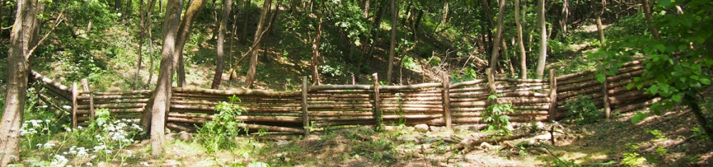
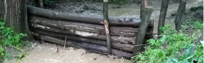
Peak flow control structures are designed to reduce flow velocities and quantities of water running down from catchment areas. Leaky dams are peak flow control structures that are made from wood and allow low flows to pass through, but hold back high flows, thus providing temporary storage and enhanced infiltartion of flood water. The structures are elevated 30 cm above streambed level to allow baseflow (and fish) to pass through. The technology is usually applied in hilly areas covered by forest. Woody check dams are made from whole tree trunks sourced locally, placed across the watercourse and secured into place with stakes and wire on both sides of the bank. The purpose is to control sediment and to slow flow velocities and quantities of water running down from catchment areas, in order to reduce flood peaks. The impact of the technology is to retain sediment and water in the upstream part of the catchment to reduce the size of flood peaks, this way avoiding flash floods downstream. The cost of installation and ongoing maintenance is low. However, leaky dams need to be cleared of debris and sediment occasionally so that water can still flow through the gaps. This reduces the likelihood of water flowing over the top of the barrier. The approximate lifetime of a leaky woody dam is about ten years, depending on the tree species used.
2.3 Photos of the Technology
Media Gallery
2.4 Videos of the Technology
Comments, short description:
https://youtu.be/1TnzpVUoDUc
6-min video on the application of leaky woody dams and other water retention measures in Püspökszilágy village.
Location:
Püspökszilágy
Name of videographer:
Filmever Studio
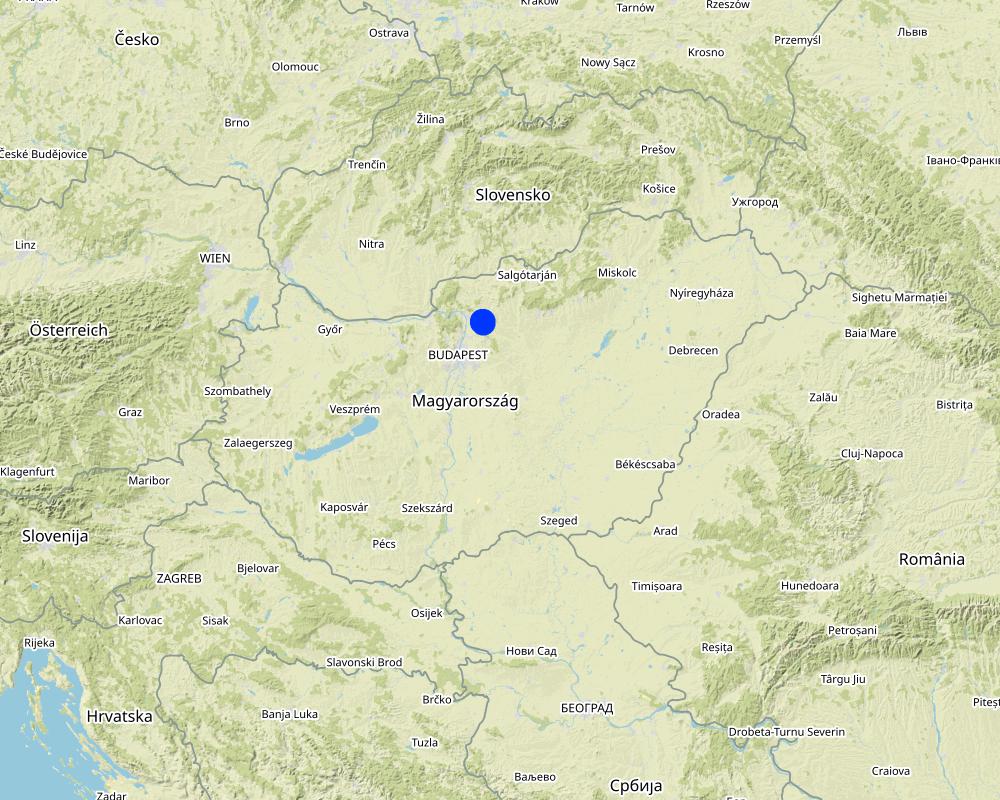
2.5 Country/ region/ locations where the Technology has been applied and which are covered by this assessment
Country:
Hungary
Region/ State/ Province:
Pest County
Further specification of location:
Püspökszilágy
Specify the spread of the Technology:
- applied at specific points/ concentrated on a small area
Is/are the technology site(s) located in a permanently protected area?
No
Map
×2.6 Date of implementation
Indicate year of implementation:
2020
2.7 Introduction of the Technology
Specify how the Technology was introduced:
- during experiments/ research
- through projects/ external interventions
3. Classification of the SLM Technology
3.1 Main purpose(s) of the Technology
- reduce, prevent, restore land degradation
- protect a watershed/ downstream areas – in combination with other Technologies
- reduce risk of disasters
- adapt to climate change/ extremes and its impacts
3.2 Current land use type(s) where the Technology is applied
Land use mixed within the same land unit:
No

Forest/ woodlands
- (Semi-)natural forests/ woodlands
(Semi-)natural forests/ woodlands: Specify management type:
- Dead wood/ prunings removal
Type of (semi-)natural forest:
- temperate continental forest natural vegetation
Are the trees specified above deciduous or evergreen?
- deciduous
Products and services:
- Nature conservation/ protection
- Recreation/ tourism
- Protection against natural hazards

Waterways, waterbodies, wetlands
- Drainage lines, waterways
- gullies
3.3 Has land use changed due to the implementation of the Technology?
Has land use changed due to the implementation of the Technology?
- No (Continue with question 3.4)
3.4 Water supply
Water supply for the land on which the Technology is applied:
- rainfed
3.5 SLM group to which the Technology belongs
- cross-slope measure
- surface water management (spring, river, lakes, sea)
- ecosystem-based disaster risk reduction
3.6 SLM measures comprising the Technology

structural measures
- S5: Dams, pans, ponds
- S6: Walls, barriers, palisades, fences
3.7 Main types of land degradation addressed by the Technology

soil erosion by water
- Wt: loss of topsoil/ surface erosion
- Wg: gully erosion/ gullying
- Wo: offsite degradation effects
3.8 Prevention, reduction, or restoration of land degradation
Specify the goal of the Technology with regard to land degradation:
- prevent land degradation
- reduce land degradation
4. Technical specifications, implementation activities, inputs, and costs
4.1 Technical drawing of the Technology
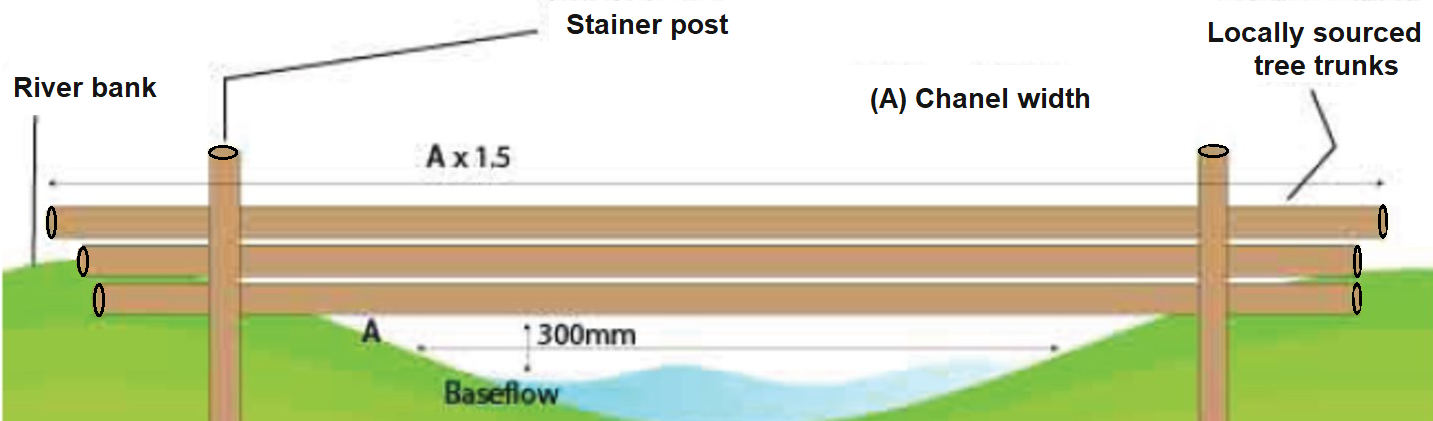
Technical specifications (related to technical drawing):
There are a few key rules to follow when installing any leaky dams:
1. They must be installed, as a minimum, in a sequence of 3.
2. The distance between each dam should be 7 times channel width.
3. The width of the dam should be 1.5 times channel width.
4. The structure should be set 300mm above base flow level.
5. Logs should be no more than 400mm in diameter.
6. Where possible, materials should be sourced locally.
7. Structures should be installed 90° to the flow.
Other recommendations for design:
- Use to obstruct flows within watercourses or along runoff pathways, gullies, valleys.
- Use in small watercourses less than 3 m wide.
- Height of a barrier should not exceed 1 m.
Author:
source: https://www.ydrt.org.uk/wp-content/uploads/2021/04/NFM-Leaky-Dams-guide.pdf and https://www.ciria.org/ItemDetail?iProductCode=C802F&Category=FREEPUBS&WebsiteKey=a054c7b1-c241-4dd4-9ec1-38afd4a55683
4.2 General information regarding the calculation of inputs and costs
Specify how costs and inputs were calculated:
- per Technology unit
Specify unit:
a single structure at multiple points in a watershed
Specify currency used for cost calculations:
- USD
4.3 Establishment activities
| Activity | Timing (season) | |
|---|---|---|
| 1. | Installing | Possible in any season. (Logging preferably out of vegetation season.) |
4.4 Costs and inputs needed for establishment
| Specify input | Unit | Quantity | Costs per Unit | Total costs per input | % of costs borne by land users | |
|---|---|---|---|---|---|---|
| Labour | Installing (team work) | person-days | 4.0 | 50.0 | 200.0 | 100.0 |
| Equipment | Machinery for installing (e.g. chainsaw, posthole digger, small excavator) rental cost | 1 | 1.0 | 200.0 | 200.0 | 100.0 |
| Plant material | No explicit cost, locally sourced wood can be used | |||||
| Construction material | Fastening device kit (e.g. metal wire, poles, clamps) | 1 | 1.0 | 200.0 | 200.0 | 100.0 |
| Total costs for establishment of the Technology | 600.0 | |||||
| Total costs for establishment of the Technology in USD | 600.0 | |||||
4.5 Maintenance/ recurrent activities
| Activity | Timing/ frequency | |
|---|---|---|
| 1. | Checking conditions of the structure | yearly or after extreme rain events |
| 2. | Cleaning of debris and sediment | if silting up starts |
| 3. | Fixing or replacing logs | if moved by flood |
4.6 Costs and inputs needed for maintenance/ recurrent activities (per year)
| Specify input | Unit | Quantity | Costs per Unit | Total costs per input | % of costs borne by land users | |
|---|---|---|---|---|---|---|
| Labour | Checking status and cleaning of debris and sediment | person-days | 1.0 | 50.0 | 50.0 | 100.0 |
| Labour | Fixing or replacing logs, if necessary | person-days | 1.0 | 50.0 | 50.0 | 100.0 |
| Equipment | Machinery rental, if necessary | 1 | 1.0 | 100.0 | 100.0 | |
| Total costs for maintenance of the Technology | 200.0 | |||||
| Total costs for maintenance of the Technology in USD | 200.0 | |||||
Comments:
Permit required on permanent watercourses. Average lifetime of a dam is about 10 years
4.7 Most important factors affecting the costs
Describe the most determinate factors affecting the costs:
Width of the water course.
Availability of locally sourced wood logs.
Availablility of equipment.
Labour costs.
Procurement rules applicable to project owner.
5. Natural and human environment
5.1 Climate
Annual rainfall
- < 250 mm
- 251-500 mm
- 501-750 mm
- 751-1,000 mm
- 1,001-1,500 mm
- 1,501-2,000 mm
- 2,001-3,000 mm
- 3,001-4,000 mm
- > 4,000 mm
Specify average annual rainfall (if known), in mm:
550.00
Specifications/ comments on rainfall:
Dry periods are becoming longer and heavy rainevents more frequent due to climate change.
Indicate the name of the reference meteorological station considered:
Püspökszilágy
Agro-climatic zone
- sub-humid
Temperate climate, four seasons, mean annual temperature: 10 degrees C
5.2 Topography
Slopes on average:
- flat (0-2%)
- gentle (3-5%)
- moderate (6-10%)
- rolling (11-15%)
- hilly (16-30%)
- steep (31-60%)
- very steep (>60%)
Landforms:
- plateau/plains
- ridges
- mountain slopes
- hill slopes
- footslopes
- valley floors
Altitudinal zone:
- 0-100 m a.s.l.
- 101-500 m a.s.l.
- 501-1,000 m a.s.l.
- 1,001-1,500 m a.s.l.
- 1,501-2,000 m a.s.l.
- 2,001-2,500 m a.s.l.
- 2,501-3,000 m a.s.l.
- 3,001-4,000 m a.s.l.
- > 4,000 m a.s.l.
Indicate if the Technology is specifically applied in:
- concave situations
5.3 Soils
Soil depth on average:
- very shallow (0-20 cm)
- shallow (21-50 cm)
- moderately deep (51-80 cm)
- deep (81-120 cm)
- very deep (> 120 cm)
Soil texture (topsoil):
- medium (loamy, silty)
Soil texture (> 20 cm below surface):
- medium (loamy, silty)
Topsoil organic matter:
- high (>3%)
5.4 Water availability and quality
Ground water table:
< 5 m
Availability of surface water:
medium
Water quality (untreated):
poor drinking water (treatment required)
Water quality refers to:
surface water
Is water salinity a problem?
No
Is flooding of the area occurring?
Yes
5.5 Biodiversity
Species diversity:
- medium
Habitat diversity:
- medium
5.6 Characteristics of land users applying the Technology
Sedentary or nomadic:
- Sedentary
Market orientation of production system:
- commercial/ market
Relative level of wealth:
- average
Individuals or groups:
- groups/ community
Level of mechanization:
- mechanized/ motorized
Gender:
- women
- men
Indicate other relevant characteristics of the land users:
The technology is applied by the municipality (local government).
5.7 Average area of land used by land users applying the Technology
- < 0.5 ha
- 0.5-1 ha
- 1-2 ha
- 2-5 ha
- 5-15 ha
- 15-50 ha
- 50-100 ha
- 100-500 ha
- 500-1,000 ha
- 1,000-10,000 ha
- > 10,000 ha
Comments:
The technology is applied by the municipality (local government).
5.8 Land ownership, land use rights, and water use rights
Land ownership:
- communal/ village
Land use rights:
- communal (organized)
Water use rights:
- communal (organized)
Are land use rights based on a traditional legal system?
Yes
5.9 Access to services and infrastructure
health:
- poor
- moderate
- good
education:
- poor
- moderate
- good
technical assistance:
- poor
- moderate
- good
employment (e.g. off-farm):
- poor
- moderate
- good
markets:
- poor
- moderate
- good
energy:
- poor
- moderate
- good
roads and transport:
- poor
- moderate
- good
drinking water and sanitation:
- poor
- moderate
- good
financial services:
- poor
- moderate
- good
6. Impacts and concluding statements
6.1 On-site impacts the Technology has shown
Ecological impacts
Water cycle/ runoff
harvesting/ collection of water
Comments/ specify:
The main purpose of this measure is slowing the movement of water during high flow events, but temporally it collect water as well providing watering place for wild animals.
surface runoff
Comments/ specify:
This measure usually takes place in forests (in the upper zone of the watershed), but it has a positive effect on the lower area (agricultural fields) of the watershed by preventing surface runoff and reducing flood events
Climate and disaster risk reduction
flood impacts
Comments/ specify:
One of the main positive effect of this measure is decreasing flash flood events and its impact both on inhabited area. Since the installation no inundation has happened. However, it may be the result of a combination of different measures.
6.2 Off-site impacts the Technology has shown
reliable and stable stream flows in dry season
downstream flooding
Comments/ specify:
One of the main positive effect of this measure is decreasing flash flood events and its impact both on inhabited area. Since the installation no inundation has happened. However, it may be the result of a combination of different measures.
damage on neighbours' fields
Comments/ specify:
The measure is a very effective solution to avoid flood damage.
damage on public/ private infrastructure
Comments/ specify:
The measure is a very effective solution to avoid flood damage.
6.3 Exposure and sensitivity of the Technology to gradual climate change and climate-related extremes/ disasters (as perceived by land users)
Climate-related extremes (disasters)
Climatological disasters
| How does the Technology cope with it? | |
|---|---|
| forest fire | not well |
Hydrological disasters
| How does the Technology cope with it? | |
|---|---|
| landslide | not well |
6.4 Cost-benefit analysis
How do the benefits compare with the establishment costs (from land users’ perspective)?
Short-term returns:
positive
Long-term returns:
positive
How do the benefits compare with the maintenance/ recurrent costs (from land users' perspective)?
Short-term returns:
positive
Long-term returns:
positive
6.5 Adoption of the Technology
- single cases/ experimental
If available, quantify (no. of households and/ or area covered):
The presented measure (in Püspökszilágy) is one of the study sites of the LIFE-MICACC project
Of all those who have adopted the Technology, how many did so spontaneously, i.e. without receiving any material incentives/ payments?
- 0-10%
Comments:
The installation costs of the measure was financed by a LIFE grant from the European Union with national co-financing.
6.6 Adaptation
Has the Technology been modified recently to adapt to changing conditions?
No
6.7 Strengths/ advantages/ opportunities of the Technology
| Strengths/ advantages/ opportunities in the land user’s view |
|---|
| Slow release of water into surrounding area (agricultural fileds) |
| Efficient temporary storage of water |
| Prevention of soil erosion |
| Strengths/ advantages/ opportunities in the compiler’s or other key resource person’s view |
|---|
| Prevention of flooding: protection of the infrastructure of the surrouanding settlements |
|
Positive effect on biodiversity: rooting habitat, place of nesting birds, areas of growth for microbes, algae and fungi available water for wildlife |
| Stabilisation of river banks |
6.8 Weaknesses/ disadvantages/ risks of the Technology and ways of overcoming them
| Weaknesses/ disadvantages/ risks in the land user’s view | How can they be overcome? |
|---|---|
| No negative effects are known |
| Weaknesses/ disadvantages/ risks in the compiler’s or other key resource person’s view | How can they be overcome? |
|---|---|
| The lifetime of a dam is limited (~10 years) |
7. References and links
7.1 Methods/ sources of information
- compilation from reports and other existing documentation
7.2 References to available publications
Title, author, year, ISBN:
A risk-based network analysis of distributed in-stream leaky barriers for flood risk management. Nat. Hazards Earth Syst. Sci., 20, 2567–2584, 2020
Available from where? Costs?
https://nhess.copernicus.org/articles/20/2567/2020/
7.3 Links to relevant online information
Title/ description:
Naturally Resilient Natural Flood Management techniques- Level 2
URL:
https://www.ydrt.org.uk/wp-content/uploads/2021/04/NFM-Leaky-Dams-guide.pdf
Title/ description:
WWF Hungary online news
URL:
https://wwf.hu/hireink/klima-es-energia/ot-hazai-telepules-mutat-peldat-hogyan-vegyuk-fel-a-harcot-a-klimavaltozassal/
Title/ description:
LIFE-MICACC project website
URL:
https://nwrm.bm.hu/
Title/ description:
WWF Hungary online news in English
URL:
https://wwfcee.org/news/five-hungarian-local-municipalities-lead-the-way-in-tackling-climate-change
7.4 General comments
-
Links and modules
Expand all Collapse allLinks
No links
Modules
No modules