Peak flow control structures (leaky woody dams) [ฮังการี]
- ผู้สร้างสรรค์:
- การอัพเดท:
- ผู้รวบรวม: Brigitta Szabó
- ผู้เรียบเรียง: Piroska Kassai, Zoltan Toth, Klara Kerpely
- ผู้ตรวจสอบ: William Critchley, Rima Mekdaschi Studer
Lefolyás-szabályozó létesítmények (szivárgó rönkgátak)
technologies_6201 - ฮังการี
ดูส่วนย่อย
ขยายทั้งหมด ย่อทั้งหมด1. ข้อมูลทั่วไป
1.2 รายละเอียดที่ติดต่อได้ของผู้รวบรวมและองค์กรที่เกี่ยวข้องในการประเมินและการจัดเตรียมทำเอกสารของเทคโนโลยี
ชื่อของโครงการซึ่งอำนวยความสะดวกในการทำเอกสารหรือการประเมินเทคโนโลยี (ถ้าเกี่ยวข้อง)
OPtimal strategies to retAIN and re-use water and nutrients in small agricultural catchments across different soil-climatic regions in Europe (OPTAIN)ชื่อของโครงการซึ่งอำนวยความสะดวกในการทำเอกสารหรือการประเมินเทคโนโลยี (ถ้าเกี่ยวข้อง)
Municipalities as integrators and coordinators in adaptation to climate change (LIFE-MICACC)ชื่อขององค์กรซึ่งอำนวยความสะดวกในการทำเอกสารหรือการประเมินเทคโนโลยี (ถ้าเกี่ยวข้อง)
Institute for Soil Sciences, Centre for Agricultural Research (ATK TAKI) - ฮังการีชื่อขององค์กรซึ่งอำนวยความสะดวกในการทำเอกสารหรือการประเมินเทคโนโลยี (ถ้าเกี่ยวข้อง)
World Wide Fund for Nature Hungary Foundation (WWF Hungary) - ฮังการี1.3 เงื่อนไขการใช้ข้อมูลที่ได้บันทึกผ่านทาง WOCAT
ผู้รวบรวมและวิทยากรหลักยอมรับเงื่อนไขเกี่ยวกับการใช้ข้อมูลที่ถูกบันทึกผ่านทาง WOCAT:
ใช่
1.4 การเปิดเผยเรื่องความยั่งยืนของเทคโนโลยีที่ได้อธิบายไว้
เทคโนโลยีที่ได้อธิบายไว้นี้เป็นปัญหาของความเสื่อมโทรมโทรมของที่ดินหรือไม่ จึงไม่ได้รับการยอมรับว่าเป็นเทคโนโลยีเพื่อการจัดการที่ดินอย่างยั่งยืน:
ไม่ใช่
2. การอธิบายลักษณะของเทคโนโลยี SLM
2.1 การอธิบายแบบสั้น ๆ ของเทคโนโลยี
คำจำกัดความของเทคโนโลยี:
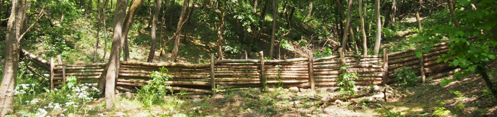
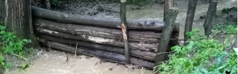
Peak flow control structures are designed to reduce flow velocities and quantities running down from catchment areas. Leaky dams are peak flow control structures that are made of wood and allow low flows to pass through, but hold back high flows, thus providing temporary storage and enhanced infiltration of flood water.
2.2 การอธิบายแบบละเอียดของเทคโนโลยี
คำอธิบาย:
Peak flow control structures are designed to reduce flow velocities and quantities of water running down from catchment areas. Leaky dams are peak flow control structures that are made from wood and allow low flows to pass through, but hold back high flows, thus providing temporary storage and enhanced infiltartion of flood water. The structures are elevated 30 cm above streambed level to allow baseflow (and fish) to pass through. The technology is usually applied in hilly areas covered by forest. Woody check dams are made from whole tree trunks sourced locally, placed across the watercourse and secured into place with stakes and wire on both sides of the bank. The purpose is to control sediment and to slow flow velocities and quantities of water running down from catchment areas, in order to reduce flood peaks. The impact of the technology is to retain sediment and water in the upstream part of the catchment to reduce the size of flood peaks, this way avoiding flash floods downstream. The cost of installation and ongoing maintenance is low. However, leaky dams need to be cleared of debris and sediment occasionally so that water can still flow through the gaps. This reduces the likelihood of water flowing over the top of the barrier. The approximate lifetime of a leaky woody dam is about ten years, depending on the tree species used.
2.3 รูปภาพของเทคโนโลยี
อัลบั้มสื่อบันทึก
2.4 วีดีโอของเทคโนโลยี
ความคิดเห็น/อธิบายสั้นๆ:
https://youtu.be/1TnzpVUoDUc
6-min video on the application of leaky woody dams and other water retention measures in Püspökszilágy village.
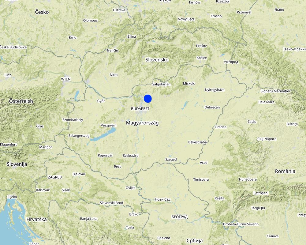
สถานที่:
Püspökszilágy
ชื่อผู้ถ่ายวีดีโอ:
Filmever Studio
2.5 ประเทศภูมิภาค หรือสถานที่ตั้งที่เทคโนโลยีได้นำไปใช้และได้รับการครอบคลุมโดยการประเมินนี้
ประเทศ:
ฮังการี
ภูมิภาค/รัฐ/จังหวัด:
Pest County
ข้อมูลจำเพาะเพิ่มเติมของสถานที่ตั้ง :
Püspökszilágy
ระบุการกระจายตัวของเทคโนโลยี:
- ใช้ ณ จุดที่เฉพาะเจาะจงหรือเน้นไปยังบริเวณพื้นที่ขนาดเล็ก
Is/are the technology site(s) located in a permanently protected area?
ไม่ใช่
Map
×2.6 วันที่การดำเนินการ
ระบุปีที่ใช้:
2020
2.7 คำแนะนำของเทคโนโลยี
ให้ระบุว่าเทคโนโลยีถูกแนะนำเข้ามาอย่างไร:
- ในช่วงการทดลองหรือการทำวิจัย
- ทางโครงการหรือจากภายนอก
3. การจัดประเภทของเทคโนโลยี SLM
3.1 วัตถุประสงค์หลักของเทคโนโลยี
- ลด ป้องกัน ฟื้นฟู การเสื่อมโทรมของที่ดิน
- ป้องกันพื้นที่ลุ่มน้ำ/บริเวณท้ายน้ำ โดยร่วมกับเทคโนโลยีอื่นๆ
- ลดความเสี่ยงของภัยพิบัติ
- ปรับตัวเข้ากับการเปลี่ยนแปลงภูมิอากาศของโลก สภาพภูมิอากาศที่รุนแรงและผลกระทบ
3.2 ประเภทของการใช้ที่ดินในปัจจุบันที่ได้นำเทคโนโลยีไปใช้
Land use mixed within the same land unit:
ไม่ใช่

ป่า/พื้นที่ทำไม้
- ป่ากึ่งธรรมชาติ / พื้นที่ทำไม้
(Semi-)natural forests/ woodlands: Specify management type:
- การเอาไม้ที่ตายแล้วออกไปหรือการตัดแต่งกิ่ง
Type of (semi-)natural forest:
- temperate continental forest natural vegetation
Are the trees specified above deciduous or evergreen?
- deciduous
ผลิตภัณฑ์และบริการ:
- การอนุรักษ์ / ป้องกันธรรมชาติ
- นันทนาการ / การท่องเที่ยว
- การป้องกันภัยธรรมชาติ

ทางน้ำ แหล่งน้ำ พื้นที่ชุ่มน้ำ
- ทางระบายน้ำ ทางน้ำ
- gullies
3.3 Has land use changed due to the implementation of the Technology?
Has land use changed due to the implementation of the Technology?
- No (Continue with question 3.4)
3.4 การใช้น้ำ
การใช้น้ำของที่ดินที่มีการใช้เทคโนโลยีอยู่:
- จากน้ำฝน
3.5 กลุ่ม SLM ที่ตรงกับเทคโนโลยีนี้
- มาตรการปลูกพืชขวางความลาดชัน (cross-slope measure)
- การจัดการน้ำผิวดิน (น้ำพุ แม่น้ำทะเลสาบ ทะเล)
- การลดความเสี่ยงจากภัยพิบัติบนพื้นฐานของระบบนิเวศ
3.6 มาตรการ SLM ที่ประกอบกันเป็นเทคโนโลยี

มาตรการอนุรักษ์ด้วยโครงสร้าง
- S5: เขื่อน ชั้นดินที่แน่นแข็งบ่อน้ำ
- S6: กำแพง สิ่งกีดขวาง รั้วไม้ รั้วต่างๆ
3.7 รูปแบบหลักของการเสื่อมโทรมของที่ดินที่ได้รับการแก้ไขโดยเทคโนโลยี

การกัดกร่อนของดินโดยน้ำ
- Wt (Loss of topsoil): การสูญเสียดินชั้นบนหรือการกัดกร่อนที่ผิวดิน
- Wg (Gully erosion): การกัดกร่อนแบบร่องธารหรือการทำให้เกิดร่องน้ำเซาะ
- Wo (Offsite degradation): ผลกระทบนอกพื้นที่
3.8 การป้องกัน การลดลง หรือการฟื้นฟูความเสื่อมโทรมของที่ดิน
ระบุเป้าหมายของเทคโนโลยีกับความเสื่อมโทรมของที่ดิน:
- ป้องกันความเสื่อมโทรมของที่ดิน
- ลดความเสื่อมโทรมของดิน
4. ข้อมูลจำเพาะด้านเทคนิค กิจกรรมการนำไปปฏิบัติใช้ ปัจจัยนำเข้า และค่าใช้จ่าย
4.1 แบบแปลนทางเทคนิคของเทคโนโลยี
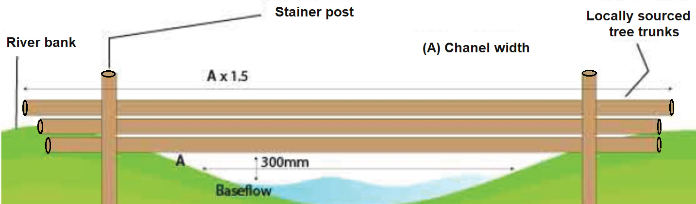
ข้อมูลจำเพาะด้านเทคนิค (แบบแปลนทางเทคนิคของเทคโนโลยี):
There are a few key rules to follow when installing any leaky dams:
1. They must be installed, as a minimum, in a sequence of 3.
2. The distance between each dam should be 7 times channel width.
3. The width of the dam should be 1.5 times channel width.
4. The structure should be set 300mm above base flow level.
5. Logs should be no more than 400mm in diameter.
6. Where possible, materials should be sourced locally.
7. Structures should be installed 90° to the flow.
Other recommendations for design:
- Use to obstruct flows within watercourses or along runoff pathways, gullies, valleys.
- Use in small watercourses less than 3 m wide.
- Height of a barrier should not exceed 1 m.
ผู้เขียน:
source: https://www.ydrt.org.uk/wp-content/uploads/2021/04/NFM-Leaky-Dams-guide.pdf and https://www.ciria.org/ItemDetail?iProductCode=C802F&Category=FREEPUBS&WebsiteKey=a054c7b1-c241-4dd4-9ec1-38afd4a55683
4.2 ข้อมูลทั่วไปเกี่ยวกับการคำนวณปัจจัยนำเข้าและค่าใช้จ่าย
ให้ระบุว่าค่าใช้จ่ายและปัจจัยนำเข้าได้รับการคำนวณอย่างไร:
- ต่อหน่วยเทคโนโลยี
โปรดระบุหน่วย:
a single structure at multiple points in a watershed
ระบุสกุลเงินที่ใช้คำนวณค่าใช้จ่าย:
- USD
4.3 กิจกรรมเพื่อการจัดตั้ง
| กิจกรรม | Timing (season) | |
|---|---|---|
| 1. | Installing | Possible in any season. (Logging preferably out of vegetation season.) |
4.4 ค่าใช้จ่ายของปัจจัยนำเข้าที่จำเป็นสำหรับการจัดตั้ง
| ปัจจัยนำเข้า | หน่วย | ปริมาณ | ค่าใช้จ่ายต่อหน่วย | ค่าใช้จ่ายทั้งหมดต่อปัจจัยนำเข้า | %ของค่าใช้จ่ายที่ก่อให้เกิดขึ้นโดยผู้ใช้ที่ดิน | |
|---|---|---|---|---|---|---|
| แรงงาน | Installing (team work) | person-days | 4.0 | 50.0 | 200.0 | 100.0 |
| อุปกรณ์ | Machinery for installing (e.g. chainsaw, posthole digger, small excavator) rental cost | 1 | 1.0 | 200.0 | 200.0 | 100.0 |
| วัสดุด้านพืช | No explicit cost, locally sourced wood can be used | |||||
| วัสดุสำหรับก่อสร้าง | Fastening device kit (e.g. metal wire, poles, clamps) | 1 | 1.0 | 200.0 | 200.0 | 100.0 |
| ค่าใช้จ่ายทั้งหมดของการจัดตั้งเทคโนโลยี | 600.0 | |||||
| Total costs for establishment of the Technology in USD | 600.0 | |||||
4.5 การบำรุงรักษาสภาพหรือกิจกรรมที่เกิดขึ้นเป็นประจำ
| กิจกรรม | ช่วงระยะเวลา/ความถี่ | |
|---|---|---|
| 1. | Checking conditions of the structure | yearly or after extreme rain events |
| 2. | Cleaning of debris and sediment | if silting up starts |
| 3. | Fixing or replacing logs | if moved by flood |
4.6 ค่าใช้จ่ายของปัจจัยนำเข้าและกิจกรรมที่เกิดขึ้นเป็นประจำที่ต้องการการบำรุงรักษา (ต่อปี)
| ปัจจัยนำเข้า | หน่วย | ปริมาณ | ค่าใช้จ่ายต่อหน่วย | ค่าใช้จ่ายทั้งหมดต่อปัจจัยนำเข้า | %ของค่าใช้จ่ายที่ก่อให้เกิดขึ้นโดยผู้ใช้ที่ดิน | |
|---|---|---|---|---|---|---|
| แรงงาน | Checking status and cleaning of debris and sediment | person-days | 1.0 | 50.0 | 50.0 | 100.0 |
| แรงงาน | Fixing or replacing logs, if necessary | person-days | 1.0 | 50.0 | 50.0 | 100.0 |
| อุปกรณ์ | Machinery rental, if necessary | 1 | 1.0 | 100.0 | 100.0 | |
| ค่าใช้จ่ายทั้งหมดของการบำรุงรักษาสภาพเทคโนโลยี | 200.0 | |||||
| Total costs for maintenance of the Technology in USD | 200.0 | |||||
แสดงความคิดเห็น:
Permit required on permanent watercourses. Average lifetime of a dam is about 10 years
4.7 ปัจจัยสำคัญที่สุดที่มีผลกระทบต่อค่าใช้จ่าย
ปัจจัยสำคัญที่สุดที่มีผลกระทบต่อค่าใช้จ่ายต่างๆ:
Width of the water course.
Availability of locally sourced wood logs.
Availablility of equipment.
Labour costs.
Procurement rules applicable to project owner.
5. สิ่งแวดล้อมทางธรรมชาติและของมนุษย์
5.1 ภูมิอากาศ
ฝนประจำปี
- < 250 ม.ม.
- 251-500 ม.ม.
- 501-750 ม.ม.
- 751-1,000 ม.ม.
- 1,001-1,500 ม.ม.
- 1,501-2,000 ม.ม.
- 2,001-3,000 ม.ม.
- 3,001-4,000 ม.ม.
- > 4,000 ม.ม.
ระบุปริมาณน้ำฝนเฉลี่ยรายปี (ถ้ารู้) :หน่วย ม.ม.
550.00
ข้อมูลจำเพาะ/ความคิดเห็นเรื่องปริมาณน้ำฝน:
Dry periods are becoming longer and heavy rainevents more frequent due to climate change.
ระบุชื่อของสถานีตรวดวัดอากาศที่ใช้อ้างอิงคือ:
Püspökszilágy
เขตภูมิอากาศเกษตร
- กึ่งชุ่มชื้น
Temperate climate, four seasons, mean annual temperature: 10 degrees C
5.2 สภาพภูมิประเทศ
ค่าเฉลี่ยความลาดชัน:
- ราบเรียบ (0-2%)
- ลาดที่ไม่ชัน (3-5%)
- ปานกลาง (6-10%)
- เป็นลูกคลื่น (11-15%)
- เป็นเนิน (16-30%)
- ชัน (31-60%)
- ชันมาก (>60%)
ธรณีสัณฐาน:
- ที่ราบสูง/ที่ราบ
- สันเขา
- ไหล่เขา
- ไหล่เนินเขา
- ตีนเนิน
- หุบเขา
ระดับความสูง:
- 0-100 เมตร
- 101-500 เมตร
- 501-1,000 เมตร
- 1,001-1,500 เมตร
- 1,501-2,000 เมตร
- 2,001-2,500 เมตร
- 2,501-3,000 เมตร
- 3,001-4,000 เมตร
- > 4,000 เมตร
ให้ระบุถ้าเทคโนโลยีได้ถูกนำไปใช้:
- บริเวณแอ่งบนที่ราบ (concave situations)
5.3 ดิน
ค่าเฉลี่ยความลึกของดิน:
- ตื้นมาก (0-20 ซ.ม.)
- ตื้น (21-50 ซ.ม.)
- ลึกปานกลาง (51-80 ซ.ม.)
- ลึก (81-120 ซ.ม.)
- ลึกมาก (>120 ซ.ม.)
เนื้อดิน (ดินชั้นบน):
- ปานกลาง (ดินร่วน ทรายแป้ง)
เนื้อดินล่าง (> 20 ซ.ม.ต่ำจากผิวดิน):
- ปานกลาง (ดินร่วน ทรายแป้ง)
อินทรียวัตถุในดิน:
- สูง (>3%)
5.4 ความเป็นประโยชน์และคุณภาพของน้ำ
ระดับน้ำใต้ดิน:
<5 เมตร
น้ำไหลบ่าที่ผิวดิน:
ปานกลาง
คุณภาพน้ำ (ที่ยังไม่ได้บำบัด):
เป็นน้ำเพื่อการดื่มที่ไม่ดี (จำเป็นต้องได้รับการบำบัด)
Water quality refers to:
surface water
ความเค็มของน้ำเป็นปัญหาหรือไม่:
ไม่ใช่
กำลังเกิดน้ำท่วมในพื้นที่หรือไม่:
ใช่
5.5 ความหลากหลายทางชีวภาพ
ความหลากหลายทางชนิดพันธุ์:
- ปานกลาง
ความหลากหลายของแหล่งที่อยู่:
- ปานกลาง
5.6 ลักษณะของผู้ใช้ที่ดินที่นำเทคโนโลยีไปปฏิบัติใช้
อยู่กับที่หรือเร่ร่อน:
- อยู่กับที่
แนวทางการตลาดของระบบการผลิต:
- ทำการค้า/การตลาด
ระดับของความมั่งคั่งโดยเปรียบเทียบ:
- พอมีพอกิน
เป็นรายบุคคล/ครัวเรือน:
- กลุ่ม/ชุมชน
ระดับของการใช้เครื่องจักรกล:
- การใช้เครื่องจักรหรือเครื่องยนต์
เพศ:
- หญิง
- ชาย
ระบุลักษณะอื่นๆที่เกี่ยวข้องของผู้ใช้ที่ดิน:
The technology is applied by the municipality (local government).
5.7 Average area of land used by land users applying the Technology
- < 0.5 เฮกตาร์
- 0.5-1 เฮกตาร์
- 1-2 เฮกตาร์
- 2-5 เฮกตาร์
- 5-15 เฮกตาร์
- 15-50 เฮกตาร์
- 50-100 เฮกตาร์
- 100-500 เฮกตาร์
- 500-1,000 เฮกตาร์
- 1,000-10,000 เฮกตาร์
- >10,000 เฮกตาร์
แสดงความคิดเห็น:
The technology is applied by the municipality (local government).
5.8 กรรมสิทธิ์ในที่ดิน สิทธิในการใช้ที่ดินและสิทธิในการใช้น้ำ
กรรมสิทธิ์ในที่ดิน:
- เป็นแบบชุมชนหรือหมู่บ้าน
สิทธิในการใช้ที่ดิน:
- เกี่ยวกับชุมชน (ถูกจัดระเบียบ)
สิทธิในการใช้น้ำ:
- เกี่ยวกับชุมชน (ถูกจัดระเบียบ)
Are land use rights based on a traditional legal system?
ใช่
5.9 การเข้าถึงบริการและโครงสร้างพื้นฐาน
สุขภาพ:
- จน
- ปานกลาง
- ดี
การศึกษา:
- จน
- ปานกลาง
- ดี
ความช่วยเหลือทางด้านเทคนิค:
- จน
- ปานกลาง
- ดี
การจ้างงาน (เช่น ภายนอกฟาร์ม):
- จน
- ปานกลาง
- ดี
ตลาด:
- จน
- ปานกลาง
- ดี
พลังงาน:
- จน
- ปานกลาง
- ดี
ถนนและการขนส่ง:
- จน
- ปานกลาง
- ดี
น้ำดื่มและการสุขาภิบาล:
- จน
- ปานกลาง
- ดี
บริการด้านการเงิน:
- จน
- ปานกลาง
- ดี
6. ผลกระทบและสรุปคำบอกกล่าว
6.1 ผลกระทบในพื้นที่ดำเนินการ (On-site) จากการใช้เทคโนโลยี
ผลกระทบด้านนิเวศวิทยา
วัฐจักรน้ำหรือน้ำบ่า
การเก็บเกี่ยวหรือการกักเก็บน้ำ
แสดงความคิดเห็น/ระบุ:
The main purpose of this measure is slowing the movement of water during high flow events, but temporally it collect water as well providing watering place for wild animals.
น้ำไหลบ่าที่ผิวดิน
แสดงความคิดเห็น/ระบุ:
This measure usually takes place in forests (in the upper zone of the watershed), but it has a positive effect on the lower area (agricultural fields) of the watershed by preventing surface runoff and reducing flood events
ลดความเสี่ยงของภัยพิบัติ
ผลกระทบจากน้ำท่วม
แสดงความคิดเห็น/ระบุ:
One of the main positive effect of this measure is decreasing flash flood events and its impact both on inhabited area. Since the installation no inundation has happened. However, it may be the result of a combination of different measures.
6.2 ผลกระทบนอกพื้นที่ดำเนินการ (Off-site) จากการใช้เทคโนโลยี
การไหลของน้ำคงที่และสม่ำเสมอในช่วงฤดูแล้ง
น้ำท่วมพื้นที่ท้ายน้ำ
แสดงความคิดเห็น/ระบุ:
One of the main positive effect of this measure is decreasing flash flood events and its impact both on inhabited area. Since the installation no inundation has happened. However, it may be the result of a combination of different measures.
ความเสียหายต่อพื้นที่เพาะปลูกของเพื่อนบ้าน
แสดงความคิดเห็น/ระบุ:
The measure is a very effective solution to avoid flood damage.
ความเสียหายต่อโครงสร้างพื้นฐานของรัฐหรือของเอกชน
แสดงความคิดเห็น/ระบุ:
The measure is a very effective solution to avoid flood damage.
6.3 การเผชิญและความตอบสนองของเทคโนโลยีต่อการเปลี่ยนแปลงสภาพภูมิอากาศที่ค่อยเป็นค่อยไป และสภาพรุนแรงของภูมิอากาศ / ภัยพิบัติ (ที่รับรู้ได้โดยผู้ใช้ที่ดิน)
สภาพรุนแรงของภูมิอากาศ (ภัยพิบัติ)
ภัยพิบัติจากสภาพภูมิอากาศ
| เทคโนโลยีมีวิธีการรับมืออย่างไร | |
|---|---|
| ไฟป่า | ไม่ค่อยดี |
ภัยพิบัติจากน้ำ
| เทคโนโลยีมีวิธีการรับมืออย่างไร | |
|---|---|
| ดินถล่ม | ไม่ค่อยดี |
6.4 การวิเคราะห์ค่าใช้จ่ายและผลประโยชน์ที่ได้รับ
ผลประโยชน์ที่ได้รับเปรียบเทียบกับค่าใช้จ่ายในการจัดตั้งเป็นอย่างไร (จากมุมมองของผู้ใช้ที่ดิน)
ผลตอบแทนระยะสั้น:
ด้านบวก
ผลตอบแทนระยะยาว:
ด้านบวก
ผลประโยชน์ที่ได้รับเปรียบเทียบกับค่าใช้จ่ายในการบำรุงรักษาหรือต้นทุนที่เกิดขึ้นซ้ำอีก เป็นอย่างไร (จากมุมมองของผู้ใช้ที่ดิน)
ผลตอบแทนระยะสั้น:
ด้านบวก
ผลตอบแทนระยะยาว:
ด้านบวก
6.5 การปรับตัวของเทคโนโลยี
- ครั้งเดียวหรือเป็นการทดลอง
ถ้ามีข้อมูลให้บอกปริมาณด้วย (จำนวนของครัวเรือนหรือครอบคลุมพื้นที่):
The presented measure (in Püspökszilágy) is one of the study sites of the LIFE-MICACC project
Of all those who have adopted the Technology, how many did so spontaneously, i.e. without receiving any material incentives/ payments?
- 0-10%
แสดงความคิดเห็น:
The installation costs of the measure was financed by a LIFE grant from the European Union with national co-financing.
6.6 การปรับตัว
เทคโนโลยีได้รับการปรับเปลี่ยนเมื่อเร็วๆนี้ เพื่อให้ปรับตัวเข้ากับสภาพที่กำลังเปลี่ยนแปลงหรือไม่:
ไม่ใช่
6.7 จุดแข็ง / ข้อได้เปรียบ / โอกาสของเทคโนโลยี
| จุดแข็ง / ข้อได้เปรียบ / โอกาสในทัศนคติของผู้ใช้ที่ดิน |
|---|
| Slow release of water into surrounding area (agricultural fileds) |
| Efficient temporary storage of water |
| Prevention of soil erosion |
| จุดแข็ง / ข้อได้เปรียบ / โอกาสในทัศนคติของผู้รวบรวมหรือวิทยากรหลัก |
|---|
| Prevention of flooding: protection of the infrastructure of the surrouanding settlements |
|
Positive effect on biodiversity: rooting habitat, place of nesting birds, areas of growth for microbes, algae and fungi available water for wildlife |
| Stabilisation of river banks |
6.8 จุดอ่อน / ข้อเสียเปรียบ / ความเสี่ยงของเทคโนโลยีและวิธีการแก้ไข
| จุดอ่อน / ข้อเสียเปรียบ / ความเสี่ยงในทัศนคติของผู้ใช้ที่ดิน | มีวิธีการแก้ไขได้อย่างไร |
|---|---|
| No negative effects are known |
| จุดอ่อน / ข้อเสียเปรียบ / ความเสี่ยงในทัศนคติของผู้รวบรวมหรือวิทยากรหลัก | มีวิธีการแก้ไขได้อย่างไร |
|---|---|
| The lifetime of a dam is limited (~10 years) |
7. การอ้างอิงและการเชื่อมต่อ
7.1 วิธีการและแหล่งข้อมูล
- การเก็บรวบรวมมาจากรายงานและเอกสารที่มีอยู่
7.2 การอ้างอิงถึงสิ่งตีพิมพ์
หัวข้อ, ผู้เขียน, ปี, หมายเลข ISBN:
A risk-based network analysis of distributed in-stream leaky barriers for flood risk management. Nat. Hazards Earth Syst. Sci., 20, 2567–2584, 2020
ชื่อเรื่อง ผู้เขียน ปี ISBN:
https://nhess.copernicus.org/articles/20/2567/2020/
7.3 Links to relevant online information
ชื่อเรื่องหรือคำอธิบาย:
Naturally Resilient Natural Flood Management techniques- Level 2
URL:
https://www.ydrt.org.uk/wp-content/uploads/2021/04/NFM-Leaky-Dams-guide.pdf
ชื่อเรื่องหรือคำอธิบาย:
WWF Hungary online news
URL:
https://wwf.hu/hireink/klima-es-energia/ot-hazai-telepules-mutat-peldat-hogyan-vegyuk-fel-a-harcot-a-klimavaltozassal/
ชื่อเรื่องหรือคำอธิบาย:
LIFE-MICACC project website
URL:
https://nwrm.bm.hu/
ชื่อเรื่องหรือคำอธิบาย:
WWF Hungary online news in English
URL:
https://wwfcee.org/news/five-hungarian-local-municipalities-lead-the-way-in-tackling-climate-change
7.4 General comments
-
ลิงก์และโมดูล
ขยายทั้งหมด ย่อทั้งหมดลิงก์
ไม่มีลิงก์
โมดูล
ไม่มีโมดูล