Eradication of Lantana Camara (invasive species) for Soil Rehabilitation on Private Land [India]
- Creation:
- Update:
- Compiler: Santosh Gupta
- Editors: Noel Templer, Stephanie Katsir, Kim Arora, Tabitha Nekesa, Ahmadou Gaye, Siagbé Golli
- Reviewers: Udo Höggel, Joana Eichenberger, Sally Bunning
Lantana (Ram Phool)
technologies_6660 - India
- Full summary as PDF
- Full summary as PDF for print
- Full summary in the browser
- Full summary (unformatted)
- Eradication of Lantana Camara (invasive species) for Soil Rehabilitation on Private Land: June 21, 2023 (inactive)
- Eradication of Lantana Camara (invasive species) for Soil Rehabilitation on Private Land: Sept. 14, 2023 (inactive)
- Eradication of Lantana Camara (invasive species) for Soil Rehabilitation on Private Land: April 11, 2024 (public)
View sections
Expand all Collapse all1. General information
1.2 Contact details of resource persons and institutions involved in the assessment and documentation of the Technology
Key resource person(s)
SLM specialist:
1.3 Conditions regarding the use of data documented through WOCAT
The compiler and key resource person(s) accept the conditions regarding the use of data documented through WOCAT:
Yes
1.4 Declaration on sustainability of the described Technology
Is the Technology described here problematic with regard to land degradation, so that it cannot be declared a sustainable land management technology?
No
2. Description of the SLM Technology
2.1 Short description of the Technology
Definition of the Technology:
Lantana camara is an invasive species having severe ecological impacts on local biodiversity and economic impact on local communities. Lantana camara has proliferated in central India and occupied many forest lands, commons, and private land. The cut rootstock method provides minimum disturbance to the soil, wherein the plants' roots are cut three inches below the ground. It is followed by lifting the bush and keeping it upside down to prevent it from gaining ground.
2.2 Detailed description of the Technology
Description:
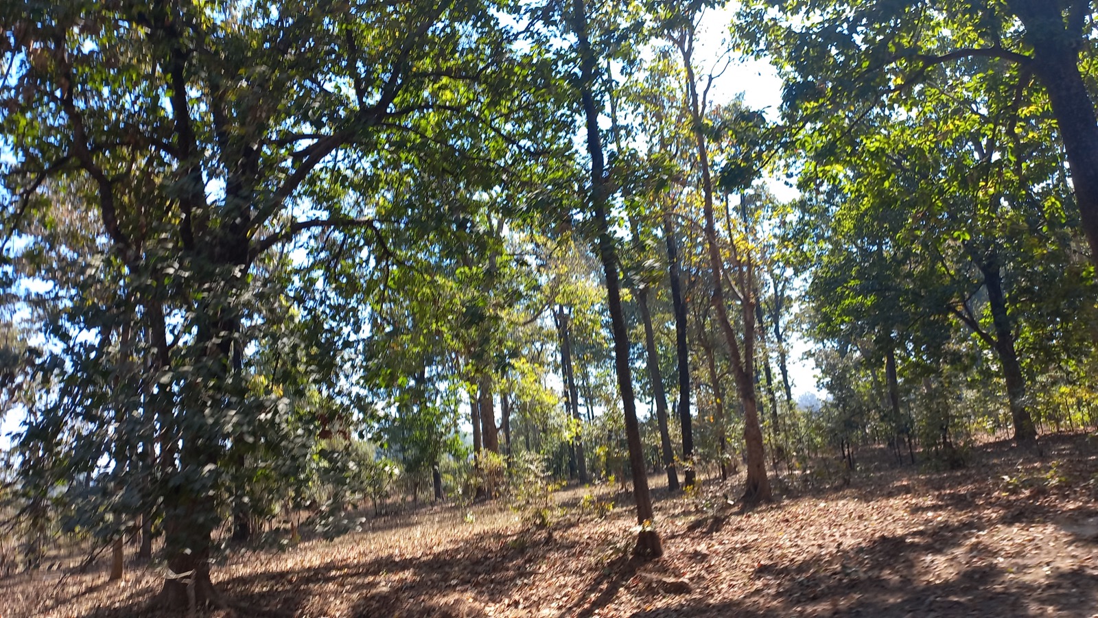
Introduced as an ornamental plant to India in the 1800s, Lantana has infested the forests, grazing grounds, and farmlands. It has invaded over 13 million hectares, which is around 4% of the total land area of the country. In the context of Madhya Pradesh, the species has encroached on shared and remote villages’ lands along the fringes of protected areas such as the Kanha Tiger Reserve, impacting wildlife and local communities in multiple ways.
Tribals in the Kanha landscape generally inhabit upper catchments of rivers, usually having large portions of uplands as part of their landholdings. These lands have never attracted investments from land development projects. They used to cultivate millets (particularly Kodo and Kutki) every alternate year. Apart from this crop, the farmers collect tendu leaves (Diospyros Melanoxylon) from these lands every year. Keeping the soil quality in view, they take these crops every alternate year and in some cases, once in three years with a gap of two years. This gap of two years helps Lantana spread on private land.
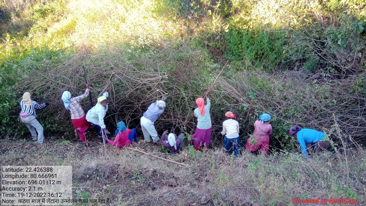
Traditional practices for controlling lantana camara are chopping the main stem, clipping aerial shoots, burning, and grubbing (total uprooting). These practices however, either led to vigorous regeneration of Lantana or were labor intensive. The cut rootstock method/technology applied under the project provides minimum disturbance to the soil, wherein the plants’ roots are cut three inches below the ground. It is followed by lifting the bush and keeping it upside down to prevent it from gaining ground.
The Foundation for Ecological Security (FES), an NGO located in India, has been working on the eradication of Lantana Camara from the commons land since 2010-11, however from the year 2016-17 onwards, with the support from GIZ, FES also started supporting village institution in eradicating Lantana from private upland. Significant activities are undertaken for the eradication of Lantana and as shown hereunder:
A. Improving community governance mechanism; local communities were engaged by ensuring that the village executive committee took the Gram Sabha (Village Governing Body) into confidence and prepared the by-laws to conserve the lantana-eradicated site. Rules and regulations were framed for the uprooting of the Lantana, its payment process, and usages of the uprooted Lantana for fencing the plot, preparation of biochar, or other usages providing ecological benefits.
B. Adoption of the ‘cut rootstock method’ for the uprooting of Lantana; removing Lantana is tricky because methods such as burning, haphazard uprooting, or cutting result in the recurrence of the species.
C. Appropriate measures were taken to minimize the recurrence of Lantana seeds through regular monitoring and plantation of grass seeds and other plants.
D. Grass seed sowing; with the active support of the village institution, the collection of indigenous grass species was done. Before the advent of the monsoon, the community prepared the grass seed ball and sowed it in the plot. A seed ball helps the seed to protect it from insects, birds, and runoff. In the rainy season, these grass seeds germinate and grow. With the grasses coming, the lantana seeds do not get a suitable environment to germinate and grow.
Eradication of Lantana from the private lands helps the communities access their lands. This has resulted in the cultivation of millets on the same land, which was otherwise left fallow for so many years.
2.3 Photos of the Technology
Media Gallery
2.5 Country/ region/ locations where the Technology has been applied and which are covered by this assessment
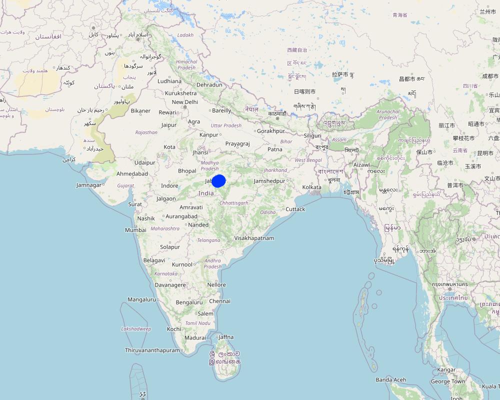
Country:
India
Region/ State/ Province:
Madhya Pradesh
Further specification of location:
Mandla
Specify the spread of the Technology:
- applied at specific points/ concentrated on a small area
Is/are the technology site(s) located in a permanently protected area?
No
Map
×2.6 Date of implementation
Indicate year of implementation:
2015
2.7 Introduction of the Technology
Specify how the Technology was introduced:
- during experiments/ research
- through projects/ external interventions
Comments (type of project, etc.):
FES has done extensive research and studies to find out the appropriate technologies and approaches to remove the lantana
3. Classification of the SLM Technology
3.1 Main purpose(s) of the Technology
- reduce, prevent, restore land degradation
- conserve ecosystem
- preserve/ improve biodiversity
- create beneficial economic impact
3.2 Current land use type(s) where the Technology is applied
Land use mixed within the same land unit:
Yes
Specify mixed land use (crops/ grazing/ trees):
- Agroforestry

Cropland
- Annual cropping
Annual cropping - Specify crops:
- cereals - millet
Annual cropping system:
Fallow - maize/sorghum/millet
Number of growing seasons per year:
- 1
Is intercropping practiced?
No
Is crop rotation practiced?
Yes
If yes, specify:
Maize-Sorghum-Millet-Fallow

Grazing land
Extensive grazing:
- Transhumant pastoralism
Intensive grazing/ fodder production:
- Cut-and-carry/ zero grazing
Animal type:
- cattle - dairy
Is integrated crop-livestock management practiced?
No
Species:
cattle - dairy
Count:
500

Forest/ woodlands
- (Semi-)natural forests/ woodlands
(Semi-)natural forests/ woodlands: Specify management type:
- Dead wood/ prunings removal
- Non-wood forest use
Type of (semi-)natural forest:
- boreal coniferous forest natural vegetation
- Madhuca Indica
Are the trees specified above deciduous or evergreen?
- mixed deciduous/ evergreen
Products and services:
- Timber
- Fuelwood
- Fruits and nuts
- Other forest products
- Grazing/ browsing
- Nature conservation/ protection
3.3 Has land use changed due to the implementation of the Technology?
Has land use changed due to the implementation of the Technology?
- Yes (Please fill out the questions below with regard to the land use before implementation of the Technology)

Unproductive land
Specify:
The land was not cultivated by the farmers due to high density of lantana.
3.4 Water supply
Water supply for the land on which the Technology is applied:
- rainfed
3.5 SLM group to which the Technology belongs
- agroforestry
- integrated soil fertility management
3.6 SLM measures comprising the Technology

vegetative measures
- V3: Clearing of vegetation
- V4: Replacement or removal of alien/ invasive species

management measures
- M1: Change of land use type
3.7 Main types of land degradation addressed by the Technology

chemical soil deterioration
- Ca: acidification

biological degradation
- Bf: detrimental effects of fires
- Bs: quality and species composition/ diversity decline
- Bl: loss of soil life
3.8 Prevention, reduction, or restoration of land degradation
Specify the goal of the Technology with regard to land degradation:
- reduce land degradation
4. Technical specifications, implementation activities, inputs, and costs
4.1 Technical drawing of the Technology
Technical specifications (related to technical drawing):
Drawing covering the landscape of private land where Lantana eradication was carried out. The drawing indicates the before and after situation with a change in the land profile. It can be seen that before the eradication land was covered with a thick cover of Lantana while after the eradication, land has plants and grass. The drawing also shows the slopes of the land under treatment.
Author:
Payal
Date:
09/03/2023
4.2 General information regarding the calculation of inputs and costs
Specify how costs and inputs were calculated:
- per Technology area
Indicate size and area unit:
1 hectare
other/ national currency (specify):
INR
If relevant, indicate exchange rate from USD to local currency (e.g. 1 USD = 79.9 Brazilian Real): 1 USD =:
80.0
Indicate average wage cost of hired labour per day:
204
4.3 Establishment activities
Comments:
No establishment cost is involved in this activity.
4.5 Maintenance/ recurrent activities
Comments:
No maintenance cost. Only one-time cost in the case of private land.
4.6 Costs and inputs needed for maintenance/ recurrent activities (per year)
| Specify input | Unit | Quantity | Costs per Unit | Total costs per input | % of costs borne by land users | |
|---|---|---|---|---|---|---|
| Labour | Removal of lantana | ha | 1.0 | 7229.0 | 7229.0 | 16.0 |
| Total costs for maintenance of the Technology | 7229.0 | |||||
| Total costs for maintenance of the Technology in USD | 90.36 | |||||
If land user bore less than 100% of costs, indicate who covered the remaining costs:
The remaning cost is being covered by the project funds routed through community participation.
Comments:
The cost varies based on the density of lantana in the field. Depending on density, it varies from Rs 7729 per ha to Rs 2808 per ha.
4.7 Most important factors affecting the costs
Describe the most determinate factors affecting the costs:
The density of lantana in the field is categorized into 3: more than 1500 bushes are considered high density, and between 500-1500 are considered moderately dense, while less than 500 is known as lowly dense.
5. Natural and human environment
5.1 Climate
Annual rainfall
- < 250 mm
- 251-500 mm
- 501-750 mm
- 751-1,000 mm
- 1,001-1,500 mm
- 1,501-2,000 mm
- 2,001-3,000 mm
- 3,001-4,000 mm
- > 4,000 mm
Specify average annual rainfall (if known), in mm:
1427.00
Specifications/ comments on rainfall:
Monsoon season is June-September which has the majority of the rainfall
Indicate the name of the reference meteorological station considered:
Mandla, Madhya Pradesh
Agro-climatic zone
- semi-arid
5.2 Topography
Slopes on average:
- flat (0-2%)
- gentle (3-5%)
- moderate (6-10%)
- rolling (11-15%)
- hilly (16-30%)
- steep (31-60%)
- very steep (>60%)
Landforms:
- plateau/plains
- ridges
- mountain slopes
- hill slopes
- footslopes
- valley floors
Altitudinal zone:
- 0-100 m a.s.l.
- 101-500 m a.s.l.
- 501-1,000 m a.s.l.
- 1,001-1,500 m a.s.l.
- 1,501-2,000 m a.s.l.
- 2,001-2,500 m a.s.l.
- 2,501-3,000 m a.s.l.
- 3,001-4,000 m a.s.l.
- > 4,000 m a.s.l.
Indicate if the Technology is specifically applied in:
- not relevant
Comments and further specifications on topography:
The topography of the project area consists of undulated terrain, hilly areas and forest areas
5.3 Soils
Soil depth on average:
- very shallow (0-20 cm)
- shallow (21-50 cm)
- moderately deep (51-80 cm)
- deep (81-120 cm)
- very deep (> 120 cm)
Soil texture (topsoil):
- coarse/ light (sandy)
- medium (loamy, silty)
Soil texture (> 20 cm below surface):
- medium (loamy, silty)
Topsoil organic matter:
- low (<1%)
5.4 Water availability and quality
Ground water table:
> 50 m
Availability of surface water:
medium
Water quality (untreated):
poor drinking water (treatment required)
Water quality refers to:
both ground and surface water
Is water salinity a problem?
No
Is flooding of the area occurring?
No
Comments and further specifications on water quality and quantity:
The locations have a river flowing close to the area; however, access to the surface and sub-surface water is a primary concern.
5.5 Biodiversity
Species diversity:
- high
Habitat diversity:
- high
Comments and further specifications on biodiversity:
The area is surrounded by Kasha National Park and Phen Wildlife Sanctuary, with a good presence of forest area. Thus biodiversity is outstanding.
5.6 Characteristics of land users applying the Technology
Sedentary or nomadic:
- Sedentary
Market orientation of production system:
- mixed (subsistence/ commercial)
Off-farm income:
- > 50% of all income
Relative level of wealth:
- poor
Individuals or groups:
- groups/ community
Level of mechanization:
- manual work
- animal traction
Gender:
- women
- men
Age of land users:
- youth
- middle-aged
5.7 Average area of land used by land users applying the Technology
- < 0.5 ha
- 0.5-1 ha
- 1-2 ha
- 2-5 ha
- 5-15 ha
- 15-50 ha
- 50-100 ha
- 100-500 ha
- 500-1,000 ha
- 1,000-10,000 ha
- > 10,000 ha
Is this considered small-, medium- or large-scale (referring to local context)?
- small-scale
5.8 Land ownership, land use rights, and water use rights
Land ownership:
- individual, titled
Land use rights:
- individual
Water use rights:
- communal (organized)
- individual
Are land use rights based on a traditional legal system?
Yes
Specify:
The concerned authorities have issued landowners the land certificates.
5.9 Access to services and infrastructure
health:
- poor
- moderate
- good
education:
- poor
- moderate
- good
technical assistance:
- poor
- moderate
- good
employment (e.g. off-farm):
- poor
- moderate
- good
markets:
- poor
- moderate
- good
energy:
- poor
- moderate
- good
roads and transport:
- poor
- moderate
- good
drinking water and sanitation:
- poor
- moderate
- good
financial services:
- poor
- moderate
- good
6. Impacts and concluding statements
6.1 On-site impacts the Technology has shown
Socio-economic impacts
Production
crop production
Quantity before SLM:
242 kg per ha
Quantity after SLM:
350 kg per ha
Comments/ specify:
These are the estimated figures
fodder production
forest/ woodland quality
production area
Water availability and quality
drinking water availability
water availability for livestock
Income and costs
farm income
diversity of income sources
Socio-cultural impacts
food security/ self-sufficiency
community institutions
SLM/ land degradation knowledge
situation of socially and economically disadvantaged groups
Ecological impacts
Soil
soil moisture
soil cover
soil loss
soil crusting/ sealing
nutrient cycling/ recharge
soil organic matter/ below ground C
Biodiversity: vegetation, animals
Vegetation cover
plant diversity
invasive alien species
beneficial species
habitat diversity
Specify assessment of on-site impacts (measurements):
Measurement of quantities required a very detailed study, which is not available at this point of time. Hence, many ratings given above are based on estimates.
6.2 Off-site impacts the Technology has shown
water availability
Comments/ specify:
Increasing soil moisture in the uplands will help improve water availability in the lowlands
buffering/ filtering capacity
6.4 Cost-benefit analysis
How do the benefits compare with the establishment costs (from land users’ perspective)?
Short-term returns:
very positive
Long-term returns:
very positive
How do the benefits compare with the maintenance/ recurrent costs (from land users' perspective)?
Short-term returns:
positive
Long-term returns:
very positive
Comments:
Short- and long-term benefits are pretty high compared to the cost involved.
6.5 Adoption of the Technology
- 1-10%
If available, quantify (no. of households and/ or area covered):
1000 hectares
Of all those who have adopted the Technology, how many did so spontaneously, i.e. without receiving any material incentives/ payments?
- 11-50%
6.6 Adaptation
Has the Technology been modified recently to adapt to changing conditions?
No
6.7 Strengths/ advantages/ opportunities of the Technology
| Strengths/ advantages/ opportunities in the land user’s view |
|---|
| 1. Availability of additional land for cultivation of other crops such as Millets on upland |
| 2. Improved land for fodder cultivation |
| 3. Reduced losses due to animal attacks on the standing crops as animals are now not finding the space to hide |
| Strengths/ advantages/ opportunities in the compiler’s or other key resource person’s view |
|---|
| Reduced human-animal conflict will lead to productivity gains for both forest dwellers and wild animals |
| Available land will be used for millet cultivation, which is rich in nutrition and well-suited to the local ecological conditions. The requirement for water is also very minimal for these crops. |
| This will also improve local biodiversity as farmers will now grow more plant varieties suitable for climatic conditions. |
6.8 Weaknesses/ disadvantages/ risks of the Technology and ways of overcoming them
| Weaknesses/ disadvantages/ risks in the compiler’s or other key resource person’s view | How can they be overcome? |
|---|---|
| Cultivation of crops using chemical pesticides and fertilizers may have a negative impact on both soil and the environment | Training and handholding of the farmers around the natural and sustainable farming practices |
7. References and links
7.1 Methods/ sources of information
- field visits, field surveys
2
- interviews with land users
5
- interviews with SLM specialists/ experts
1
- compilation from reports and other existing documentation
4
When were the data compiled (in the field)?
21/02/2023
7.2 References to available publications
Title, author, year, ISBN:
FES internal documents prepared during the year 2021-22
Available from where? Costs?
Internal documents
Links and modules
Expand all Collapse allLinks
No links
Modules
No modules