Eradication of Lantana Camara (invasive species) for Soil Rehabilitation on Private Land [อินเดีย]
- ผู้สร้างสรรค์:
- การอัพเดท:
- ผู้รวบรวม: Santosh Gupta
- ผู้เรียบเรียง: Noel Templer, Stephanie Katsir, Kim Arora, Tabitha Nekesa, Ahmadou Gaye, Siagbé Golli
- ผู้ตรวจสอบ: Udo Höggel, Joana Eichenberger, Sally Bunning
Lantana (Ram Phool)
technologies_6660 - อินเดีย
- บทสรุปทั้งหมดในรูปแบบของ PDF
- บทสรุปทั้งหมดในรูปแบบของ PDF เพื่อพิมพ์
- บทสรุปทั้งหมดในรูปหน้าเว็บ
- บทสรุปทั้งหมด (ไม่มีการจัดเรียง)
- Eradication of Lantana Camara (invasive species) for Soil Rehabilitation on Private Land: 21 มิถุนายน 2023 (inactive)
- Eradication of Lantana Camara (invasive species) for Soil Rehabilitation on Private Land: 14 กันยายน 2023 (inactive)
- Eradication of Lantana Camara (invasive species) for Soil Rehabilitation on Private Land: 11 เมษายน 2024 (public)
ดูส่วนย่อย
ขยายทั้งหมด ย่อทั้งหมด1. ข้อมูลทั่วไป
1.2 รายละเอียดที่ติดต่อได้ของผู้รวบรวมและองค์กรที่เกี่ยวข้องในการประเมินและการจัดเตรียมทำเอกสารของเทคโนโลยี
ชื่อของโครงการซึ่งอำนวยความสะดวกในการทำเอกสารหรือการประเมินเทคโนโลยี (ถ้าเกี่ยวข้อง)
Soil protection and rehabilitation for food security (ProSo(i)l)ชื่อขององค์กรซึ่งอำนวยความสะดวกในการทำเอกสารหรือการประเมินเทคโนโลยี (ถ้าเกี่ยวข้อง)
Deutsche Gesellschaft für Internationale Zusammenarbeit - India (GIZ India) - อินเดียชื่อขององค์กรซึ่งอำนวยความสะดวกในการทำเอกสารหรือการประเมินเทคโนโลยี (ถ้าเกี่ยวข้อง)
CIAT International Center for Tropical Agriculture (CIAT International Center for Tropical Agriculture) - เคนยาชื่อขององค์กรซึ่งอำนวยความสะดวกในการทำเอกสารหรือการประเมินเทคโนโลยี (ถ้าเกี่ยวข้อง)
Ecociate Consultants (Ecociate Consultants) - อินเดีย1.3 เงื่อนไขการใช้ข้อมูลที่ได้บันทึกผ่านทาง WOCAT
ผู้รวบรวมและวิทยากรหลักยอมรับเงื่อนไขเกี่ยวกับการใช้ข้อมูลที่ถูกบันทึกผ่านทาง WOCAT:
ใช่
1.4 การเปิดเผยเรื่องความยั่งยืนของเทคโนโลยีที่ได้อธิบายไว้
เทคโนโลยีที่ได้อธิบายไว้นี้เป็นปัญหาของความเสื่อมโทรมโทรมของที่ดินหรือไม่ จึงไม่ได้รับการยอมรับว่าเป็นเทคโนโลยีเพื่อการจัดการที่ดินอย่างยั่งยืน:
ไม่ใช่
2. การอธิบายลักษณะของเทคโนโลยี SLM
2.1 การอธิบายแบบสั้น ๆ ของเทคโนโลยี
คำจำกัดความของเทคโนโลยี:
Lantana camara is an invasive species having severe ecological impacts on local biodiversity and economic impact on local communities. Lantana camara has proliferated in central India and occupied many forest lands, commons, and private land. The cut rootstock method provides minimum disturbance to the soil, wherein the plants' roots are cut three inches below the ground. It is followed by lifting the bush and keeping it upside down to prevent it from gaining ground.
2.2 การอธิบายแบบละเอียดของเทคโนโลยี
คำอธิบาย:
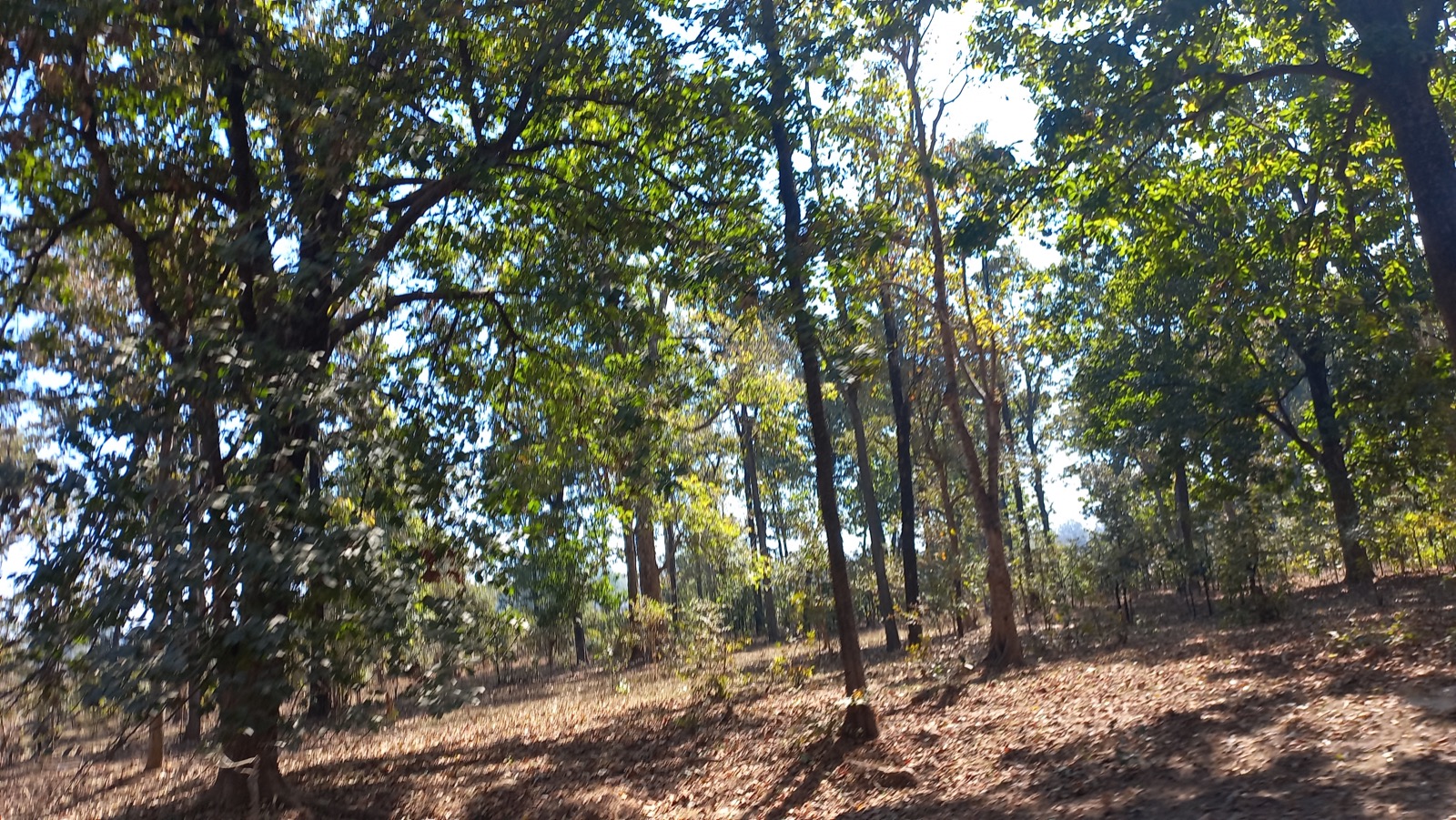
Introduced as an ornamental plant to India in the 1800s, Lantana has infested the forests, grazing grounds, and farmlands. It has invaded over 13 million hectares, which is around 4% of the total land area of the country. In the context of Madhya Pradesh, the species has encroached on shared and remote villages’ lands along the fringes of protected areas such as the Kanha Tiger Reserve, impacting wildlife and local communities in multiple ways.
Tribals in the Kanha landscape generally inhabit upper catchments of rivers, usually having large portions of uplands as part of their landholdings. These lands have never attracted investments from land development projects. They used to cultivate millets (particularly Kodo and Kutki) every alternate year. Apart from this crop, the farmers collect tendu leaves (Diospyros Melanoxylon) from these lands every year. Keeping the soil quality in view, they take these crops every alternate year and in some cases, once in three years with a gap of two years. This gap of two years helps Lantana spread on private land.
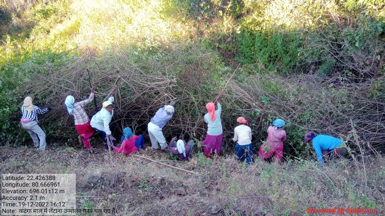
Traditional practices for controlling lantana camara are chopping the main stem, clipping aerial shoots, burning, and grubbing (total uprooting). These practices however, either led to vigorous regeneration of Lantana or were labor intensive. The cut rootstock method/technology applied under the project provides minimum disturbance to the soil, wherein the plants’ roots are cut three inches below the ground. It is followed by lifting the bush and keeping it upside down to prevent it from gaining ground.
The Foundation for Ecological Security (FES), an NGO located in India, has been working on the eradication of Lantana Camara from the commons land since 2010-11, however from the year 2016-17 onwards, with the support from GIZ, FES also started supporting village institution in eradicating Lantana from private upland. Significant activities are undertaken for the eradication of Lantana and as shown hereunder:
A. Improving community governance mechanism; local communities were engaged by ensuring that the village executive committee took the Gram Sabha (Village Governing Body) into confidence and prepared the by-laws to conserve the lantana-eradicated site. Rules and regulations were framed for the uprooting of the Lantana, its payment process, and usages of the uprooted Lantana for fencing the plot, preparation of biochar, or other usages providing ecological benefits.
B. Adoption of the ‘cut rootstock method’ for the uprooting of Lantana; removing Lantana is tricky because methods such as burning, haphazard uprooting, or cutting result in the recurrence of the species.
C. Appropriate measures were taken to minimize the recurrence of Lantana seeds through regular monitoring and plantation of grass seeds and other plants.
D. Grass seed sowing; with the active support of the village institution, the collection of indigenous grass species was done. Before the advent of the monsoon, the community prepared the grass seed ball and sowed it in the plot. A seed ball helps the seed to protect it from insects, birds, and runoff. In the rainy season, these grass seeds germinate and grow. With the grasses coming, the lantana seeds do not get a suitable environment to germinate and grow.
Eradication of Lantana from the private lands helps the communities access their lands. This has resulted in the cultivation of millets on the same land, which was otherwise left fallow for so many years.
2.3 รูปภาพของเทคโนโลยี
อัลบั้มสื่อบันทึก
2.5 ประเทศภูมิภาค หรือสถานที่ตั้งที่เทคโนโลยีได้นำไปใช้และได้รับการครอบคลุมโดยการประเมินนี้
ประเทศ:
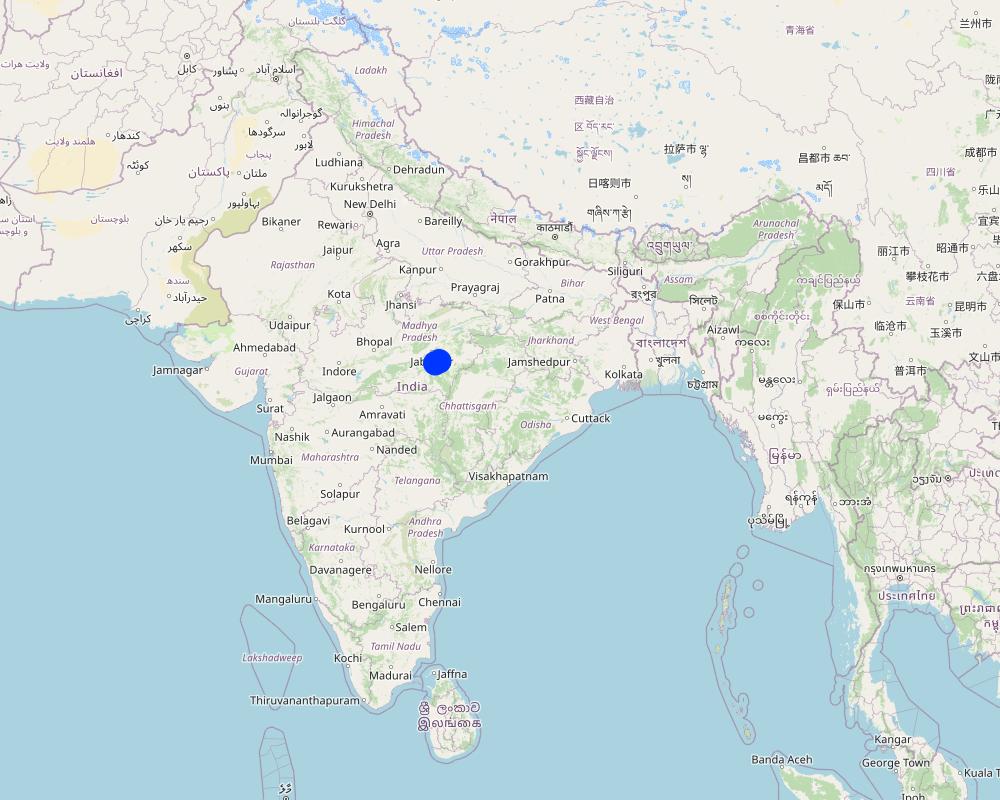
อินเดีย
ภูมิภาค/รัฐ/จังหวัด:
Madhya Pradesh
ข้อมูลจำเพาะเพิ่มเติมของสถานที่ตั้ง :
Mandla
ระบุการกระจายตัวของเทคโนโลยี:
- ใช้ ณ จุดที่เฉพาะเจาะจงหรือเน้นไปยังบริเวณพื้นที่ขนาดเล็ก
Is/are the technology site(s) located in a permanently protected area?
ไม่ใช่
Map
×2.6 วันที่การดำเนินการ
ระบุปีที่ใช้:
2015
2.7 คำแนะนำของเทคโนโลยี
ให้ระบุว่าเทคโนโลยีถูกแนะนำเข้ามาอย่างไร:
- ในช่วงการทดลองหรือการทำวิจัย
- ทางโครงการหรือจากภายนอก
ความคิดเห็น (ประเภทของโครงการ เป็นต้น) :
FES has done extensive research and studies to find out the appropriate technologies and approaches to remove the lantana
3. การจัดประเภทของเทคโนโลยี SLM
3.1 วัตถุประสงค์หลักของเทคโนโลยี
- ลด ป้องกัน ฟื้นฟู การเสื่อมโทรมของที่ดิน
- อนุรักษ์ระบบนิเวศน์
- รักษาสภาพหรือปรับปรุงความหลากหลายทางชีวภาพ
- สร้างผลกระทบทางด้านเศรษฐกิจที่เป็นประโยชน์
3.2 ประเภทของการใช้ที่ดินในปัจจุบันที่ได้นำเทคโนโลยีไปใช้
Land use mixed within the same land unit:
ใช่
Specify mixed land use (crops/ grazing/ trees):
- วนเกษตร (Agroforestry)

พื้นที่ปลูกพืช
- การปลูกพืชล้มลุกอายุปีเดียว
Annual cropping - Specify crops:
- cereals - millet
Annual cropping system:
Fallow - maize/sorghum/millet
จำนวนของฤดูเพาะปลูกต่อปี:
- 1
Is intercropping practiced?
ไม่ใช่
Is crop rotation practiced?
ใช่
ถ้าใช่ ระบุ:
Maize-Sorghum-Millet-Fallow

ทุ่งหญ้าเลี้ยงสัตว์
Extensive grazing:
- Transhumant pastoralism
ทุ่งหญ้าเลี้ยงสัตว์ที่มีการจัดการแบบเข้มข้นหรือการผลิตอาหารสัตว์:
- ตัดแล้วขนไป / ไม่มีการปล่อยแทะเล็มเอง (Cut-and-carry / zero grazing)
Animal type:
- cattle - dairy
Is integrated crop-livestock management practiced?
ไม่ใช่
Species:
cattle - dairy
Count:
500

ป่า/พื้นที่ทำไม้
- ป่ากึ่งธรรมชาติ / พื้นที่ทำไม้
(Semi-)natural forests/ woodlands: Specify management type:
- การเอาไม้ที่ตายแล้วออกไปหรือการตัดแต่งกิ่ง
- การใช้ประโยชน์จากป่า ยกเว้นไม้
Type of (semi-)natural forest:
- boreal coniferous forest natural vegetation
- Madhuca Indica
Are the trees specified above deciduous or evergreen?
- mixed deciduous/ evergreen
ผลิตภัณฑ์และบริการ:
- ไม้ซุง
- ไม้ที่นำมาทำเป็นเชื้อเพลิง
- ผลไม้และถั่ว
- ผลิตภัณฑ์อื่น ๆ จากป่า
- การแทะเล็มหญ้า / การเก็บกินหญ้า
- การอนุรักษ์ / ป้องกันธรรมชาติ
3.3 Has land use changed due to the implementation of the Technology?
Has land use changed due to the implementation of the Technology?
- Yes (Please fill out the questions below with regard to the land use before implementation of the Technology)

ที่ดินที่ไม่ให้ผลผลิต
ระบุ:
The land was not cultivated by the farmers due to high density of lantana.
3.4 การใช้น้ำ
การใช้น้ำของที่ดินที่มีการใช้เทคโนโลยีอยู่:
- จากน้ำฝน
3.5 กลุ่ม SLM ที่ตรงกับเทคโนโลยีนี้
- การปลูกป่าร่วมกับพืช
- การจัดการความอุดมสมบรูณ์ของดินแบบผสมผสาน
3.6 มาตรการ SLM ที่ประกอบกันเป็นเทคโนโลยี

มาตรการอนุรักษ์ด้วยวิธีพืช
- V3: กำจัดพืชออกให้หมด
- V4: การแทนที่หรือการนำพันธุ์ต่างถิ่น/ที่รุกล้ำเข้ามา ออกไปจากพื้นที่

มาตรการอนุรักษ์ด้วยการจัดการ
- M1: การเปลี่ยนรูปแบบของการใช้ประโยชน์ที่ดิน
3.7 รูปแบบหลักของการเสื่อมโทรมของที่ดินที่ได้รับการแก้ไขโดยเทคโนโลยี

การเสื่อมโทรมของดินทางด้านเคมี
- Ca (Acidification): การเกิดกรด

การเสื่อมโทรมของดินทางด้านชีวภาพ
- Bf (Detrimenta leffects of fires): ผลเสียหายจากไฟ
- Bs (Quality and species composition): องค์ประกอบหรือความหลากหลายทางคุณภาพและชนิดพันธุ์ลดลง
- Bl (Loss of soil life): การสูญเสียสิ่งมีชีวิตในดิน
3.8 การป้องกัน การลดลง หรือการฟื้นฟูความเสื่อมโทรมของที่ดิน
ระบุเป้าหมายของเทคโนโลยีกับความเสื่อมโทรมของที่ดิน:
- ลดความเสื่อมโทรมของดิน
4. ข้อมูลจำเพาะด้านเทคนิค กิจกรรมการนำไปปฏิบัติใช้ ปัจจัยนำเข้า และค่าใช้จ่าย
4.1 แบบแปลนทางเทคนิคของเทคโนโลยี
ข้อมูลจำเพาะด้านเทคนิค (แบบแปลนทางเทคนิคของเทคโนโลยี):
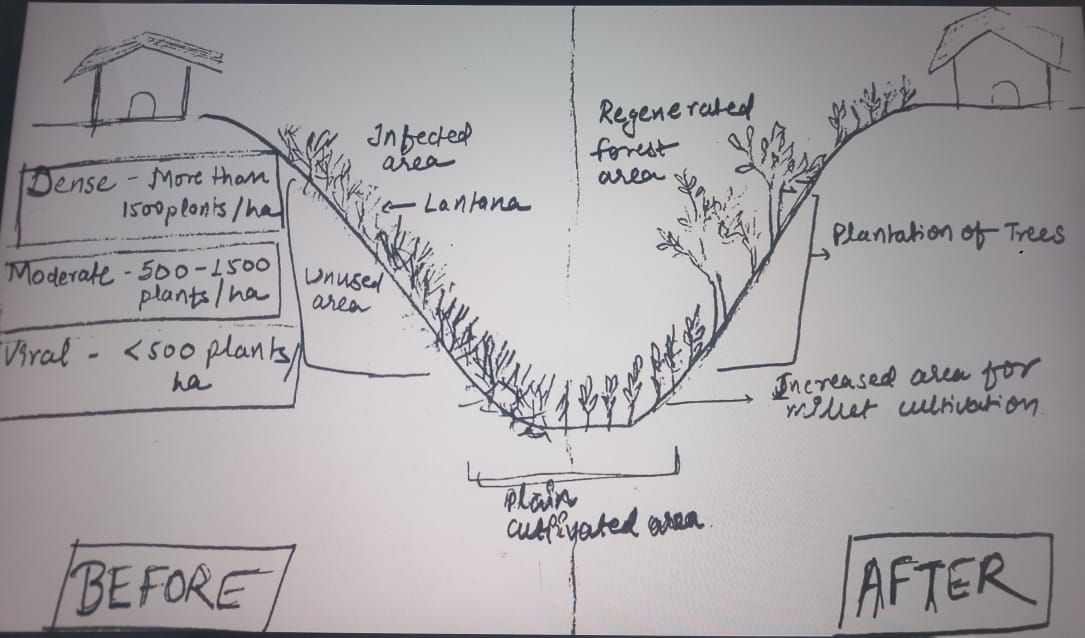
Drawing covering the landscape of private land where Lantana eradication was carried out. The drawing indicates the before and after situation with a change in the land profile. It can be seen that before the eradication land was covered with a thick cover of Lantana while after the eradication, land has plants and grass. The drawing also shows the slopes of the land under treatment.
ผู้เขียน:
Payal
วันที่:
09/03/2023
4.2 ข้อมูลทั่วไปเกี่ยวกับการคำนวณปัจจัยนำเข้าและค่าใช้จ่าย
ให้ระบุว่าค่าใช้จ่ายและปัจจัยนำเข้าได้รับการคำนวณอย่างไร:
- ต่อพื้นที่ที่ใช้เทคโนโลยี
ระบุขนาดและหน่วยพื้นที่:
1 hectare
อื่นๆ หรือสกุลเงินประจำชาติ (ระบุ):
INR
If relevant, indicate exchange rate from USD to local currency (e.g. 1 USD = 79.9 Brazilian Real): 1 USD =:
80.0
ระบุค่าเฉลี่ยของค่าจ้างในการจ้างแรงงานต่อวัน:
204
4.3 กิจกรรมเพื่อการจัดตั้ง
แสดงความคิดเห็น:
No establishment cost is involved in this activity.
4.5 การบำรุงรักษาสภาพหรือกิจกรรมที่เกิดขึ้นเป็นประจำ
แสดงความคิดเห็น:
No maintenance cost. Only one-time cost in the case of private land.
4.6 ค่าใช้จ่ายของปัจจัยนำเข้าและกิจกรรมที่เกิดขึ้นเป็นประจำที่ต้องการการบำรุงรักษา (ต่อปี)
| ปัจจัยนำเข้า | หน่วย | ปริมาณ | ค่าใช้จ่ายต่อหน่วย | ค่าใช้จ่ายทั้งหมดต่อปัจจัยนำเข้า | %ของค่าใช้จ่ายที่ก่อให้เกิดขึ้นโดยผู้ใช้ที่ดิน | |
|---|---|---|---|---|---|---|
| แรงงาน | Removal of lantana | ha | 1.0 | 7229.0 | 7229.0 | 16.0 |
| ค่าใช้จ่ายทั้งหมดของการบำรุงรักษาสภาพเทคโนโลยี | 7229.0 | |||||
| Total costs for maintenance of the Technology in USD | 90.36 | |||||
ถ้าผู้ใช้ที่ดินรับภาระน้อยกว่า 100% ของค่าใช้จ่าย ให้ระบุว่าใครเป็นผู้รับผิดชอบส่วนที่เหลือ:
The remaning cost is being covered by the project funds routed through community participation.
แสดงความคิดเห็น:
The cost varies based on the density of lantana in the field. Depending on density, it varies from Rs 7729 per ha to Rs 2808 per ha.
4.7 ปัจจัยสำคัญที่สุดที่มีผลกระทบต่อค่าใช้จ่าย
ปัจจัยสำคัญที่สุดที่มีผลกระทบต่อค่าใช้จ่ายต่างๆ:
The density of lantana in the field is categorized into 3: more than 1500 bushes are considered high density, and between 500-1500 are considered moderately dense, while less than 500 is known as lowly dense.
5. สิ่งแวดล้อมทางธรรมชาติและของมนุษย์
5.1 ภูมิอากาศ
ฝนประจำปี
- < 250 ม.ม.
- 251-500 ม.ม.
- 501-750 ม.ม.
- 751-1,000 ม.ม.
- 1,001-1,500 ม.ม.
- 1,501-2,000 ม.ม.
- 2,001-3,000 ม.ม.
- 3,001-4,000 ม.ม.
- > 4,000 ม.ม.
ระบุปริมาณน้ำฝนเฉลี่ยรายปี (ถ้ารู้) :หน่วย ม.ม.
1427.00
ข้อมูลจำเพาะ/ความคิดเห็นเรื่องปริมาณน้ำฝน:
Monsoon season is June-September which has the majority of the rainfall
ระบุชื่อของสถานีตรวดวัดอากาศที่ใช้อ้างอิงคือ:
Mandla, Madhya Pradesh
เขตภูมิอากาศเกษตร
- กึ่งแห้งแล้ง
5.2 สภาพภูมิประเทศ
ค่าเฉลี่ยความลาดชัน:
- ราบเรียบ (0-2%)
- ลาดที่ไม่ชัน (3-5%)
- ปานกลาง (6-10%)
- เป็นลูกคลื่น (11-15%)
- เป็นเนิน (16-30%)
- ชัน (31-60%)
- ชันมาก (>60%)
ธรณีสัณฐาน:
- ที่ราบสูง/ที่ราบ
- สันเขา
- ไหล่เขา
- ไหล่เนินเขา
- ตีนเนิน
- หุบเขา
ระดับความสูง:
- 0-100 เมตร
- 101-500 เมตร
- 501-1,000 เมตร
- 1,001-1,500 เมตร
- 1,501-2,000 เมตร
- 2,001-2,500 เมตร
- 2,501-3,000 เมตร
- 3,001-4,000 เมตร
- > 4,000 เมตร
ให้ระบุถ้าเทคโนโลยีได้ถูกนำไปใช้:
- ไม่เกี่ยวข้อง
ความคิดเห็นและข้อมูลจำเพาะเพิ่มเติมเรื่องสภาพภูมิประเทศ:
The topography of the project area consists of undulated terrain, hilly areas and forest areas
5.3 ดิน
ค่าเฉลี่ยความลึกของดิน:
- ตื้นมาก (0-20 ซ.ม.)
- ตื้น (21-50 ซ.ม.)
- ลึกปานกลาง (51-80 ซ.ม.)
- ลึก (81-120 ซ.ม.)
- ลึกมาก (>120 ซ.ม.)
เนื้อดิน (ดินชั้นบน):
- หยาบ/เบา (ดินทราย)
- ปานกลาง (ดินร่วน ทรายแป้ง)
เนื้อดินล่าง (> 20 ซ.ม.ต่ำจากผิวดิน):
- ปานกลาง (ดินร่วน ทรายแป้ง)
อินทรียวัตถุในดิน:
- ต่ำ (<1%)
5.4 ความเป็นประโยชน์และคุณภาพของน้ำ
ระดับน้ำใต้ดิน:
> 50 เมตร
น้ำไหลบ่าที่ผิวดิน:
ปานกลาง
คุณภาพน้ำ (ที่ยังไม่ได้บำบัด):
เป็นน้ำเพื่อการดื่มที่ไม่ดี (จำเป็นต้องได้รับการบำบัด)
Water quality refers to:
both ground and surface water
ความเค็มของน้ำเป็นปัญหาหรือไม่:
ไม่ใช่
กำลังเกิดน้ำท่วมในพื้นที่หรือไม่:
ไม่ใช่
ความคิดเห็นและข้อมูลจำเพาะเพิ่มเติมเรื่องคุณภาพและปริมาณน้ำ:
The locations have a river flowing close to the area; however, access to the surface and sub-surface water is a primary concern.
5.5 ความหลากหลายทางชีวภาพ
ความหลากหลายทางชนิดพันธุ์:
- สูง
ความหลากหลายของแหล่งที่อยู่:
- สูง
ความคิดเห็นและข้อมูลจำเพาะเพิ่มเติมของความหลากหลายทางชีวภาพ:
The area is surrounded by Kasha National Park and Phen Wildlife Sanctuary, with a good presence of forest area. Thus biodiversity is outstanding.
5.6 ลักษณะของผู้ใช้ที่ดินที่นำเทคโนโลยีไปปฏิบัติใช้
อยู่กับที่หรือเร่ร่อน:
- อยู่กับที่
แนวทางการตลาดของระบบการผลิต:
- mixed (subsistence/ commercial)
รายได้ที่มาจากนอกฟาร์ม:
- > 50% ของรายได้ทั้งหมด
ระดับของความมั่งคั่งโดยเปรียบเทียบ:
- จน
เป็นรายบุคคล/ครัวเรือน:
- กลุ่ม/ชุมชน
ระดับของการใช้เครื่องจักรกล:
- งานที่ใช้แรงกาย
- การใช้กำลังจากสัตว์
เพศ:
- หญิง
- ชาย
อายุของผู้ใช้ที่ดิน:
- ผู้เยาว์
- วัยกลางคน
5.7 Average area of land used by land users applying the Technology
- < 0.5 เฮกตาร์
- 0.5-1 เฮกตาร์
- 1-2 เฮกตาร์
- 2-5 เฮกตาร์
- 5-15 เฮกตาร์
- 15-50 เฮกตาร์
- 50-100 เฮกตาร์
- 100-500 เฮกตาร์
- 500-1,000 เฮกตาร์
- 1,000-10,000 เฮกตาร์
- >10,000 เฮกตาร์
พิจารณาว่าเป็นขนาดเล็ก กลาง หรือขนาดใหญ่ (ซึ่งอ้างอิงถึงบริบทระดับท้องถิ่น):
- ขนาดเล็ก
5.8 กรรมสิทธิ์ในที่ดิน สิทธิในการใช้ที่ดินและสิทธิในการใช้น้ำ
กรรมสิทธิ์ในที่ดิน:
- รายบุคคล ได้รับสิทธิครอบครอง
สิทธิในการใช้ที่ดิน:
- รายบุคคล
สิทธิในการใช้น้ำ:
- เกี่ยวกับชุมชน (ถูกจัดระเบียบ)
- รายบุคคล
Are land use rights based on a traditional legal system?
ใช่
ระบุ:
The concerned authorities have issued landowners the land certificates.
5.9 การเข้าถึงบริการและโครงสร้างพื้นฐาน
สุขภาพ:
- จน
- ปานกลาง
- ดี
การศึกษา:
- จน
- ปานกลาง
- ดี
ความช่วยเหลือทางด้านเทคนิค:
- จน
- ปานกลาง
- ดี
การจ้างงาน (เช่น ภายนอกฟาร์ม):
- จน
- ปานกลาง
- ดี
ตลาด:
- จน
- ปานกลาง
- ดี
พลังงาน:
- จน
- ปานกลาง
- ดี
ถนนและการขนส่ง:
- จน
- ปานกลาง
- ดี
น้ำดื่มและการสุขาภิบาล:
- จน
- ปานกลาง
- ดี
บริการด้านการเงิน:
- จน
- ปานกลาง
- ดี
6. ผลกระทบและสรุปคำบอกกล่าว
6.1 ผลกระทบในพื้นที่ดำเนินการ (On-site) จากการใช้เทคโนโลยี
ผลกระทบทางด้านเศรษฐกิจและสังคม
การผลิต
การผลิตพืชผล
จำนวนก่อน SLM:
242 kg per ha
หลังจาก SLM:
350 kg per ha
แสดงความคิดเห็น/ระบุ:
These are the estimated figures
การผลิตพืชที่ใช้เลี้ยงปศุสัตว์
คุณภาพป่า /พื้นที่ทำไม้
พื้นที่สำหรับการผลิต
ความเป็นประโยชน์และคุณภาพของน้ำ
การมีน้ำดื่มไว้ให้ใช้
การมีน้ำไว้ให้ปศุสัตว์
รายได้และค่าใช้จ่าย
รายได้จากฟาร์ม
ความหลากหลายของแหล่งผลิตรายได้
ผลกระทบด้านสังคมวัฒนธรรมอื่น ๆ
ความมั่นคงด้านอาหาร / พึ่งตนเองได้
สถาบันของชุมชน
SLM หรือความรู้เรื่องความเสื่อมโทรมของที่ดิน
สถานการณ์ของกลุ่มด้อยโอกาส ทางด้านสังคมและเศรษฐกิจ
ผลกระทบด้านนิเวศวิทยา
ดิน
ความชื้นในดิน
สิ่งปกคลุมดิน
การสูญเสียดิน
การเกิดแผ่นแข็งที่ผิวดิน /การเกิดชั้นดาน
การหมุนเวียนและการเติมของธาตุอาหาร
อินทรียวัตถุในดิน/ต่ำกว่าดินชั้น C
ความหลากหลายทางชีวภาพของพืชและสัตว์
การปกคลุมด้วยพืช
ความหลากหลายทางชีวภาพของพืช
พืชพันธุ์ต่างถิ่นที่รุกล้ำเข้ามา
ชนิดพันธุ์ที่ให้ประโยชน์
ความหลากหลายของสัตว์
Specify assessment of on-site impacts (measurements):
Measurement of quantities required a very detailed study, which is not available at this point of time. Hence, many ratings given above are based on estimates.
6.2 ผลกระทบนอกพื้นที่ดำเนินการ (Off-site) จากการใช้เทคโนโลยี
น้ำที่ใช้ประโยชน์ได้
แสดงความคิดเห็น/ระบุ:
Increasing soil moisture in the uplands will help improve water availability in the lowlands
ความสามารถต้านทานการเปลี่ยนแปลง / ความสามารถในการคัดกรอง
6.4 การวิเคราะห์ค่าใช้จ่ายและผลประโยชน์ที่ได้รับ
ผลประโยชน์ที่ได้รับเปรียบเทียบกับค่าใช้จ่ายในการจัดตั้งเป็นอย่างไร (จากมุมมองของผู้ใช้ที่ดิน)
ผลตอบแทนระยะสั้น:
ด้านบวกอย่างมาก
ผลตอบแทนระยะยาว:
ด้านบวกอย่างมาก
ผลประโยชน์ที่ได้รับเปรียบเทียบกับค่าใช้จ่ายในการบำรุงรักษาหรือต้นทุนที่เกิดขึ้นซ้ำอีก เป็นอย่างไร (จากมุมมองของผู้ใช้ที่ดิน)
ผลตอบแทนระยะสั้น:
ด้านบวก
ผลตอบแทนระยะยาว:
ด้านบวกอย่างมาก
แสดงความคิดเห็น:
Short- and long-term benefits are pretty high compared to the cost involved.
6.5 การปรับตัวของเทคโนโลยี
- 1-10%
ถ้ามีข้อมูลให้บอกปริมาณด้วย (จำนวนของครัวเรือนหรือครอบคลุมพื้นที่):
1000 hectares
Of all those who have adopted the Technology, how many did so spontaneously, i.e. without receiving any material incentives/ payments?
- 11-50%
6.6 การปรับตัว
เทคโนโลยีได้รับการปรับเปลี่ยนเมื่อเร็วๆนี้ เพื่อให้ปรับตัวเข้ากับสภาพที่กำลังเปลี่ยนแปลงหรือไม่:
ไม่ใช่
6.7 จุดแข็ง / ข้อได้เปรียบ / โอกาสของเทคโนโลยี
| จุดแข็ง / ข้อได้เปรียบ / โอกาสในทัศนคติของผู้ใช้ที่ดิน |
|---|
| 1. Availability of additional land for cultivation of other crops such as Millets on upland |
| 2. Improved land for fodder cultivation |
| 3. Reduced losses due to animal attacks on the standing crops as animals are now not finding the space to hide |
| จุดแข็ง / ข้อได้เปรียบ / โอกาสในทัศนคติของผู้รวบรวมหรือวิทยากรหลัก |
|---|
| Reduced human-animal conflict will lead to productivity gains for both forest dwellers and wild animals |
| Available land will be used for millet cultivation, which is rich in nutrition and well-suited to the local ecological conditions. The requirement for water is also very minimal for these crops. |
| This will also improve local biodiversity as farmers will now grow more plant varieties suitable for climatic conditions. |
6.8 จุดอ่อน / ข้อเสียเปรียบ / ความเสี่ยงของเทคโนโลยีและวิธีการแก้ไข
| จุดอ่อน / ข้อเสียเปรียบ / ความเสี่ยงในทัศนคติของผู้รวบรวมหรือวิทยากรหลัก | มีวิธีการแก้ไขได้อย่างไร |
|---|---|
| Cultivation of crops using chemical pesticides and fertilizers may have a negative impact on both soil and the environment | Training and handholding of the farmers around the natural and sustainable farming practices |
7. การอ้างอิงและการเชื่อมต่อ
7.1 วิธีการและแหล่งข้อมูล
- ไปเยี่ยมชมภาคสนาม การสำรวจพื้นที่ภาคสนาม
2
- การสัมภาษณ์กับผู้ใช้ที่ดิน
5
- การสัมภาษณ์ผู้เชี่ยวชาญด้าน SLM หรือผู้ชำนาญ
1
- การเก็บรวบรวมมาจากรายงานและเอกสารที่มีอยู่
4
วันที่เก็บรวบรวมข้อมูล(ภาคสนาม) :
21/02/2023
7.2 การอ้างอิงถึงสิ่งตีพิมพ์
หัวข้อ, ผู้เขียน, ปี, หมายเลข ISBN:
FES internal documents prepared during the year 2021-22
ชื่อเรื่อง ผู้เขียน ปี ISBN:
Internal documents
ลิงก์และโมดูล
ขยายทั้งหมด ย่อทั้งหมดลิงก์
ไม่มีลิงก์
โมดูล
ไม่มีโมดูล