Tabia [突尼斯]
- 创建:
- 更新:
- 编制者: Mongi Ben Zaied
- 编辑者: –
- 审查者: Deborah Niggli, Alexandra Gavilano
technologies_1420 - 突尼斯
查看章节
全部展开 全部收起1. 一般信息
1.2 参与该技术评估和文件编制的资源人员和机构的联系方式
关键资源人
SLM专业人员:
Sghaier Mongi
Institut des Régions Arides IRA
突尼斯
SLM专业人员:
Chniter Mongi
Commissariats Régionaux au Développement Agricole CRDA
突尼斯
SLM专业人员:
有助于对技术进行记录/评估的项目名称(如相关)
DESIRE (EU-DES!RE)有助于对技术进行记录/评估的项目名称(如相关)
Book project: Water Harvesting – Guidelines to Good Practice (Water Harvesting)有助于对技术进行记录/评估的机构名称(如相关)
Institut des Régions Arides de Médenine (Institut des Régions Arides de Médenine) - 突尼斯有助于对技术进行记录/评估的机构名称(如相关)
Commissariats Régionaux au Développement Agricole (CRDA) - 突尼斯1.3 关于使用通过WOCAT记录的数据的条件
编制者和关键资源人员接受有关使用通过WOCAT记录数据的条件。:
是
1.5 参考关于SLM方法(使用WOCAT记录的SLM方法)的调查问卷
Territorial Natural Resource Management Observatory [突尼斯]
A territorial natural resources management observatory is a scientific, technical and institutional system set up in a given area to observe, monitor and improve knowledge.
- 编制者: Wafa Saidi
Projet d'Aménagement et de Développement Intégré du Territoire … [突尼斯]
Le Projet d'Aménagement et de Développement Intégré du Territoire (PADIT) est basé sur la sollicitation des populations locales et la collaboration avec tous les acteurs impliqués dans la gestion des ressources naturelles et du développement rural afin de valoriser les atouts d'un territoire donné et élaborer un plan d'action intégré …
- 编制者: Wafa Saidi
Collecte des eaux pluviales dans des citernes [突尼斯]
Les citernes sont construites soit par l’état dans les zones enclavées où l’approvisionnement en eaux potables et difficile voire impossible par le réseau de la Société Nationale d’Exploitation et de Distribution des Eaux (SONEDE) soit par des particuliers pour collecter les eaux de pluies. Ces ouvrages sont destinés à l’abreuvement …
- 编制者: Donia Mühlematter

Conservation des eaux et des sols suivant la … [突尼斯]
Les tabias sont développés dans les piedmonts des Djebels et les plaines à pente légère (n’excédant pas les 3 %) du centre et du sud tunisien où la pluviométrie annuelle est relativement faible. Les zones aménagées en tabias reçoivent annuellement un supplément d’eau de ruissellement permettant une agriculture pluviale très …
- 编制者: Donia Mühlematter
Dryland watershed management approach [突尼斯]
Integrated land and water management approach, including vegetative, management, and agronomic measure
- 编制者: Naceur Mahdi
2. SLM技术的说明
2.1 技术简介
技术定义:
The tabia earthen dyke is a water harvesting technique used in the foothill and piedmont areas.
2.2 技术的详细说明
说明:
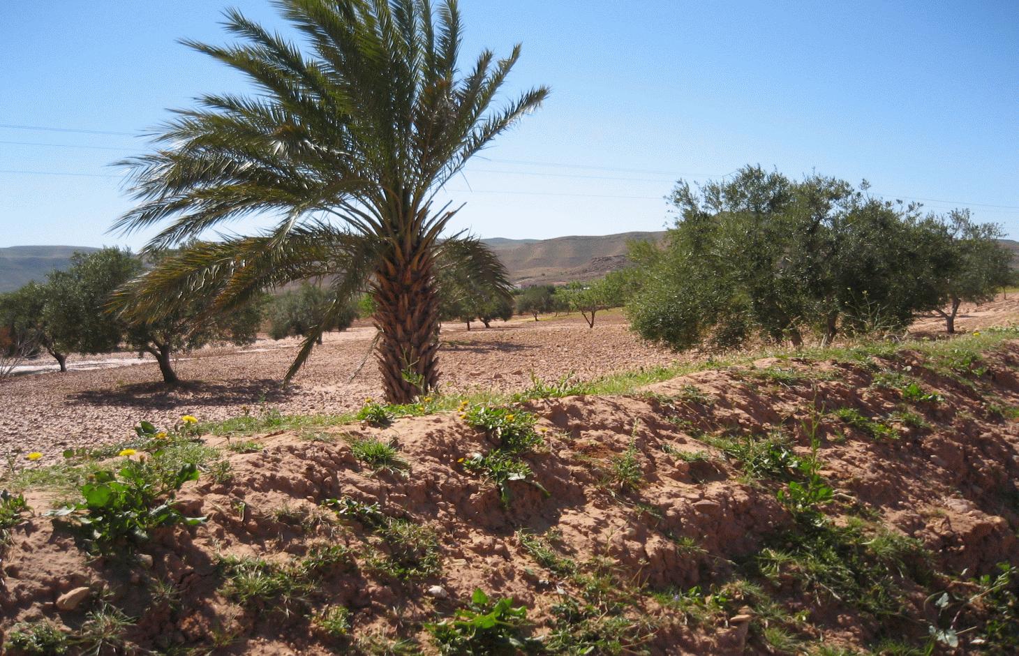
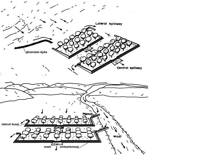
The tabia technology is similar to the jessour system but is used in the gently-sloping foothill and piedmont areas. It is considered to be a relatively new technique, developed by mountain dwellers who migrated to the plains. Tabias, like jessour, comprise an earthen dyke (50-150 m in length, 1-2 m in height), a spillway (central and/or lateral) and an associated water harvesting area. The ratio between the area where water is applied (cropped area) and the total area from which water is collected varies from 1:6 to 1:20. The differences between the tabia and the jessour systems are that the former contains two additional lateral bunds (up to 30 m long) and sometimes a small flood diversion dyke (mgoud). Small tabia are constructed manually using shovels, pickles and carts. Larger constructions are done mechanically using tractors and bulldozers.
Purpose of the Technology: Tree products and annual crops are commonly grown using tabia. Besides their water harvesting qualities, tabias also have a positive effect on soil erosion and groundwater recharge.
Natural / human environment: The tabia runoff-water harvesting technique is widely practised in central Tunisia. Tabias are usually installed on the piedmont, where the slope does not exceed 3% and where the soil is relatively deep. Ancient remnants of tabias have been found in the region of Gafsa (south west Tunisia). The system has been adopted by people living in the neighbouring foothills and plains of the central and southeastern regions (Jeffara) of the country, following the transformation of their pasture to cultivated fields.
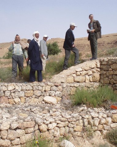
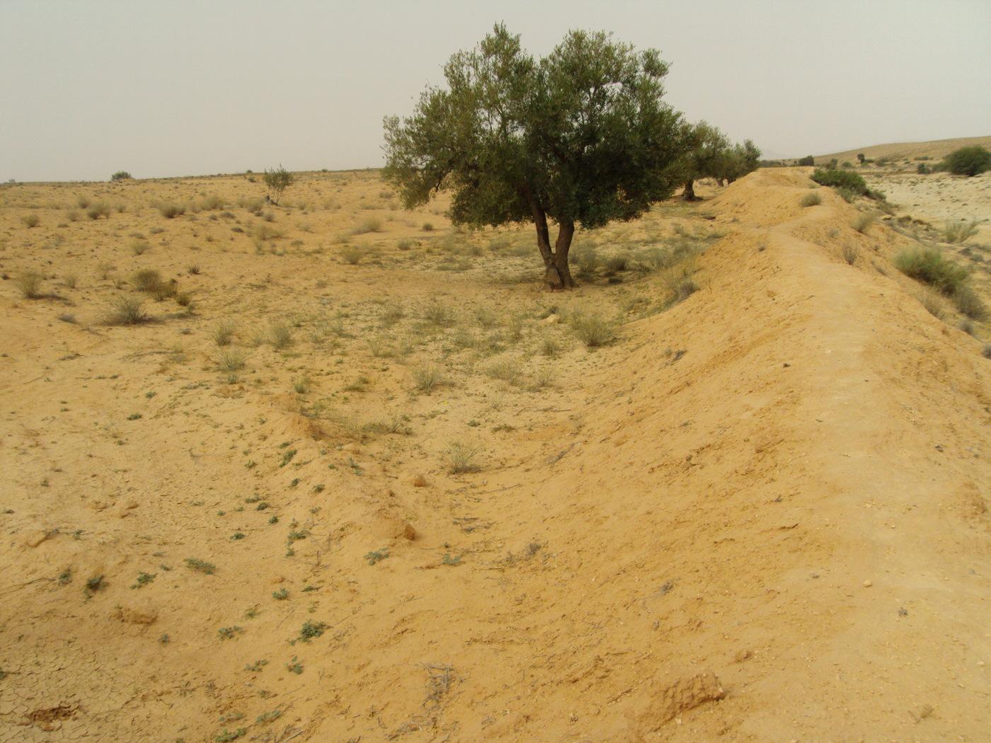
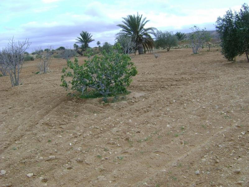
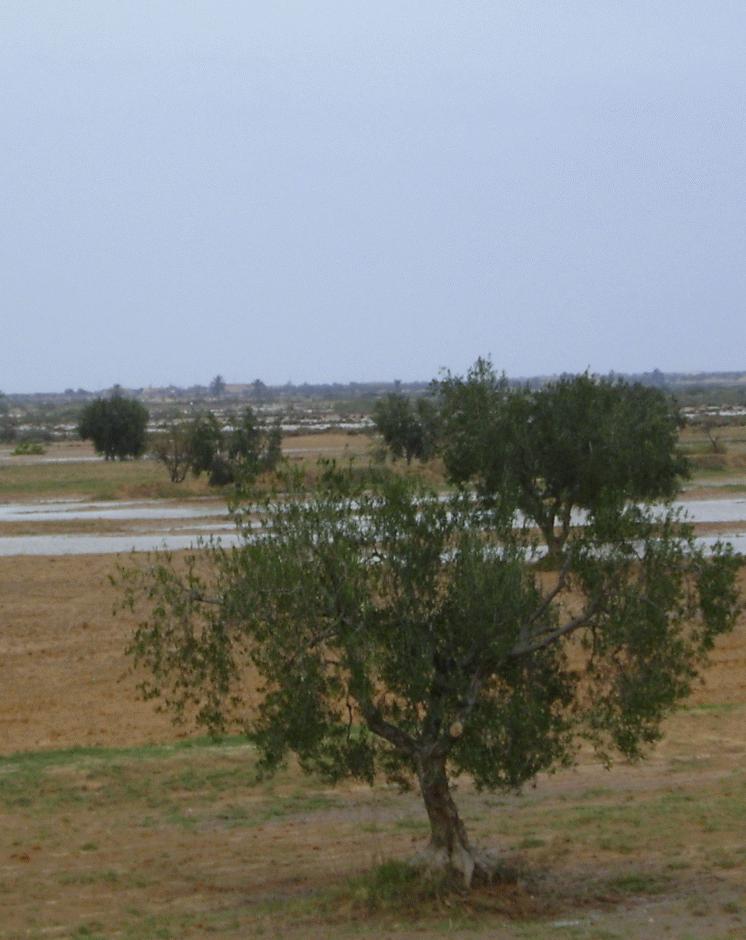
2.3 技术照片
媒体库
2.5 已应用该技术的、本评估所涵盖的国家/地区/地点
国家:
突尼斯
区域/州/省:
Medenine
有关地点的进一步说明:
Medenine nord
具体说明该技术的分布:
- 均匀地分布在一个区域
如果不知道精确的区域,请注明大致覆盖的区域:
- 10-100 平方千米
Map
×2.6 实施日期
如果不知道确切的年份,请说明大概的日期:
- 10-50年前
2.7 技术介绍
详细说明该技术是如何引入的:
- 通过项目/外部干预
3. SLM技术的分类
3.2 应用该技术的当前土地利用类型

农田
- 乔木与灌木的种植
每年的生长季节数:
- 1
具体说明:
Période de croissance la plus longue en jour: 180,Période de croissance la plus longue d'un mois à l'autre: Octobre - Avril

牧场
注释:
Problèmes principaux d'utilisation des terres (avis du compilateur): érosion hydrique des sols, ruissellement et perte de terre, surpâturage
Major land use problems (land users’ perception): overgrazing
3.4 供水
该技术所应用土地的供水:
- 混合雨水灌溉
3.5 该技术所属的SLM组
- 集水
3.6 包含该技术的可持续土地管理措施

结构措施
- S2:堤、岸
注释:
Main measures: structural measures
3.7 该技术强调的主要土地退化类型

土壤水蚀
- Wt:表土流失/地表侵蚀
- Wg:冲沟侵蚀/沟蚀
注释:
Main type of degradation addressed: Wt: loss of topsoil / surface erosion
Secondary types of degradation addressed: Wg: gully erosion / gullying
Main causes of degradation: Heavy / extreme rainfall (intensity/amounts), land tenure
Secondary causes of degradation: overgrazing, population pressure
3.8 防止、减少或恢复土地退化
具体数量名该技术与土地退化有关的目标:
- 防止土地退化
- 减少土地退化
注释:
Main goals: prevention of land degradation
Secondary goals: mitigation / reduction of land degradation
4. 技术规范、实施活动、投入和成本
4.1 该技术的技术图纸
技术规范(与技术图纸相关):
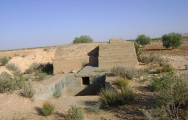
Tabia avec zone de collecte d'eau naturelle (supérieure) et tabia sur un système agrandi avec dérivation d'eau supplémentaire (inférieure). (Adapté d'Alaya et al., 1993)
Trouvé dans les zones plus plates, tabia peut accueillir plus d'arbres sur la terrasse en particulier quand il peut recevoir d'eau supplémentaire des inondations.
Localisation: Tunisie sud-est
Date: Janvier 2009
Connaissances techniques requises pour le personnel sur le terrain / conseillers: moyen
Connaissances techniques requises pour les utilisateurs des terres: moyen
Fonctions principales techniques: contrôle du ruissellement en ravines: rétention/capture
Fonctions techniques secondaire: augmentation de l'infiltration, récupération de l’eau / augmentation des réserves d’eau, épandage des eaux
Détournement de dérivation / drainage
Hauteur des bunds/barrages/autres (m): 2
Largeur des bunds/barrages/autres (m): 2-5
Longueur des bunds/barrages/autres (m): 10-30
Déversoir
Hauteur des bunds/barrages/autres (m): 1
Largeur des bunds/barrages/autres (m): 5
Length of bunds/banks/others (m): 2-4
Mur de protection/ rive: rectifié
Intervalle verticales entres les structures (m): 3
Espacement entre les structures (m): 100
Hauteur des bunds/barragues/autres (m): 2
Largeur des bunds/barrages/autres (m): 2-5
Longueur des bunds/barrages/autres (m): 50-150
Materiel de construction (terre): Digue principale
Materiel de construction (Pierres): Déversoir
Materiel de construction (béton): Déversoir
Materiel de construction (autres): Gabion: digue de dérivation
Gradient latéral le long de la structure: 1%
Pour la récolte de l'eau: Ratio entre la zone où l'eau récoltée est appliquée et la superficie totale d'où provient l'eau est 1:4
作者:
Adapted from Alaya et al. 1993
4.2 有关投入和成本计算的一般信息
其它/国家货币(具体说明):
TND
如相关,注明美元与当地货币的汇率(例如1美元=79.9巴西雷亚尔):1美元=:
1.3
注明雇用劳工的每日平均工资成本:
10.00
4.3 技术建立活动
| 活动 | 时间(季度) | |
|---|---|---|
| 1. | Diversion channel | in the case of tabia on spreading system |
| 2. | Plantation | |
| 3. | Spillway construction | |
| 4. | Terracing |
4.4 技术建立所需要的费用和投入
| 对投入进行具体说明 | 单位 | 数量 | 单位成本 | 每项投入的总成本 | 土地使用者承担的成本% | |
|---|---|---|---|---|---|---|
| 劳动力 | Labour | ha | 1.0 | 500.0 | 500.0 | 100.0 |
| 施工材料 | ha | 1.0 | 170.0 | 170.0 | 100.0 | |
| 技术建立所需总成本 | 670.0 | |||||
| 技术建立总成本,美元 | 515.38 | |||||
注释:
Duration of establishment phase: 1 month(s)
4.5 维护/经常性活动
| 活动 | 时间/频率 | |
|---|---|---|
| 1. | Dyke and spillway maintenance | Annually |
| 2. | Reconstruction |
4.6 维护/经常性活动所需要的费用和投入(每年)
| 对投入进行具体说明 | 单位 | 数量 | 单位成本 | 每项投入的总成本 | 土地使用者承担的成本% | |
|---|---|---|---|---|---|---|
| 劳动力 | Labour | ha | 1.0 | 150.0 | 150.0 | 100.0 |
| 施工材料 | ha | 1.0 | 50.0 | 50.0 | 100.0 | |
| 技术维护所需总成本 | 200.0 | |||||
| 技术维护总成本,美元 | 153.85 | |||||
注释:
The technology establishment and maintenance costs met by the land users are 100% if executed on a private basis, but it can range from 10 to 50% when the site is part of a publicly-funded programme.
4.7 影响成本的最重要因素
描述影响成本的最决定性因素:
Labour is the most determining factor affecting the costs.
5. 自然和人文环境
5.1 气候
年降雨量
- < 250毫米
- 251-500毫米
- 501-750毫米
- 751-1,000毫米
- 1,001-1,500毫米
- 1,501-2,000毫米
- 2,001-3,000毫米
- 3,001-4,000毫米
- > 4,000毫米
农业气候带
- 干旱
Thermal climate class: subtropics
5.2 地形
平均坡度:
- 水平(0-2%)
- 缓降(3-5%)
- 平缓(6-10%)
- 滚坡(11-15%)
- 崎岖(16-30%)
- 陡峭(31-60%)
- 非常陡峭(>60%)
地形:
- 高原/平原
- 山脊
- 山坡
- 山地斜坡
- 麓坡
- 谷底
垂直分布带:
- 0-100 m a.s.l.
- 101-500 m a.s.l.
- 501-1,000 m a.s.l.
- 1,001-1,500 m a.s.l.
- 1,501-2,000 m a.s.l.
- 2,001-2,500 m a.s.l.
- 2,501-3,000 m a.s.l.
- 3,001-4,000 m a.s.l.
- > 4,000 m a.s.l.
5.3 土壤
平均土层深度:
- 非常浅(0-20厘米)
- 浅(21-50厘米)
- 中等深度(51-80厘米)
- 深(81-120厘米)
- 非常深(> 120厘米)
土壤质地(表土):
- 中粒(壤土、粉土)
表土有机质:
- 低(<1%)
如有可能,附上完整的土壤描述或具体说明可用的信息,例如土壤类型、土壤酸碱度、阳离子交换能力、氮、盐度等。:
Soil fertility is: very low
Soil drainage/infiltration is: medium
Soil water storage is: medium
5.4 水资源可用性和质量
地下水位表:
5-50米
地表水的可用性:
中等
水质(未处理):
不良饮用水(需要处理)
关于水质和水量的注释和进一步规范:
Water quality (untreated): Poor drinking water (treatement required/medium quality)
5.5 生物多样性
物种多样性:
- 中等
5.6 应用该技术的土地使用者的特征
生产系统的市场定位:
- 混合(生计/商业)
非农收入:
- > 收入的50%
相对财富水平:
- 贫瘠
- 平均水平
个人或集体:
- 个人/家庭
性别:
- 男人
说明土地使用者的其他有关特征:
Land users applying the Technology are mainly common / average land users
Difference in the involvement of women and men: Outdoor hard works are generally performed by men.
Population density: 10-50 persons/km2
Annual population growth: 0.5% - 1%
10% of the land users are rich and own 10% of the land.
70% of the land users are average wealthy and own 75% of the land.
20% of the land users are poor and own 15% of the land.
5.7 应用该技术的土地使用者使用的平均土地面积
- < 0.5 公顷
- 0.5-1 公顷
- 1-2 公顷
- 2-5公顷
- 5-15公顷
- 15-50公顷
- 50-100公顷
- 100-500公顷
- 500-1,000公顷
- 1,000-10,000公顷
- > 10,000公顷
这被认为是小规模、中规模还是大规模的(参照当地实际情况)?:
- 小规模的
5.8 土地所有权、土地使用权和水使用权
土地所有权:
- 个人,未命名
- 个人,有命名
土地使用权:
- 个人
用水权:
- 个人
5.9 进入服务和基础设施的通道
健康:
- 贫瘠
- 适度的
- 好
教育:
- 贫瘠
- 适度的
- 好
技术援助:
- 贫瘠
- 适度的
- 好
就业(例如非农):
- 贫瘠
- 适度的
- 好
市场:
- 贫瘠
- 适度的
- 好
能源:
- 贫瘠
- 适度的
- 好
道路和交通:
- 贫瘠
- 适度的
- 好
饮用水和卫生设施:
- 贫瘠
- 适度的
- 好
金融服务:
- 贫瘠
- 适度的
- 好
6. 影响和结论性说明
6.1 该技术的现场影响
社会经济效应
生产
作物生产
生产故障风险
收入和成本
农业收入
其它社会经济效应
Grazing land
社会文化影响
食品安全/自给自足
SLM/土地退化知识
冲突缓解
Improved livelihoods and human well-being
生态影响
水循环/径流
水的回收/收集
地表径流
地下水位/含水层
蒸发
土壤
土壤流失
6.2 该技术的场外影响已经显现
水资源可用性
旱季稳定可靠的水流
下游洪水
下游淤积
对公共/私人基础设施的破坏
6.3 技术对渐变气候以及与气候相关的极端情况/灾害的暴露和敏感性(土地使用者认为的极端情况/灾害)
渐变气候
渐变气候
| 季节 | 增加或减少 | 该技术是如何应对的? | |
|---|---|---|---|
| 年温度 | 增加 | 好 |
气候有关的极端情况(灾害)
气象灾害
| 该技术是如何应对的? | |
|---|---|
| 局地暴雨 | 好 |
| 局地风暴 | 好 |
气候灾害
| 该技术是如何应对的? | |
|---|---|
| 干旱 | 不好 |
水文灾害
| 该技术是如何应对的? | |
|---|---|
| 比较和缓的(河道)洪水 | 不好 |
其他气候相关的后果
其他气候相关的后果
| 该技术是如何应对的? | |
|---|---|
| 缩短生长期 | 好 |
6.4 成本效益分析
技术收益与技术建立成本相比如何(从土地使用者的角度看)?
短期回报:
消极
长期回报:
非常积极
技术收益与技术维护成本/经常性成本相比如何(从土地使用者的角度看)?
短期回报:
积极
长期回报:
非常积极
6.5 技术采用
在所有采用这项技术的人当中,有多少人是自发的,即未获得任何物质奖励/付款?:
- 51-90%
注释:
35% of land user families have adopted the Technology with external material support
65% of land user families have adopted the Technology without any external material support
There is a strong trend towards spontaneous adoption of the Technology
6.7 该技术的优点/长处/机会
| 土地使用者眼中的长处/优势/机会 |
|---|
| Improved production and expansion of cropping land. |
| 编制者或其他关键资源人员认为的长处/优势/机会 |
|---|
|
This technique allows a rapid expansion of cropping lands in the piedmont and flat areas How can they be sustained / enhanced? encourage maintenance of existing structure. |
|
Allows crop production in very dry environments (with less than 200 mm of rainfall) How can they be sustained / enhanced? encourage maintenance of existing structure. |
|
Collects and accumulates water, soil and nutrients behind the tabia and makes it available to crops How can they be sustained / enhanced? encourage maintenance of existing structure. |
|
Reduced damage by flooding How can they be sustained / enhanced? encourage maintenance of existing structure. |
6.8 技术的弱点/缺点/风险及其克服方法
| 土地使用者认为的弱点/缺点/风险 | 如何克服它们? |
|---|---|
| Expansion is done at the expense of natural grazing land. |
| 编制者或其他关键资源人员认为的弱点/缺点/风险 | 如何克服它们? |
|---|---|
| Risks related to the climatic changes | it needs to be combined with supplementary irrigation. |
| Drought spells | Supplemental irrigation. |
| Land ownership fragmentation | new land access / agrarian reform. |
| Productivity of the land is very low | development of alternative income generation activities. |
| Risk of local know-how disappearance | training of new generations. |
7. 参考和链接
7.1 信息的方法/来源
7.2 参考可用出版物
标题、作者、年份、ISBN:
Alaya, K., Viertmann, W., Waibel, Th. 1993. Les tabias. Imprimerie Arabe de Tunisie, Tunis, Tunisia. 192 pp.
可以从哪里获得?成本如何?
IRA
标题、作者、年份、ISBN:
Ben Mechlia, N., Ouessar, M. 2004. Water harvesting systems in Tunisia. In: Oweis, T., Hachum, A., Bruggeman, A. (eds). Indigenous water harvesting in West Asia and North Africa, , ICARDA, Aleppo, Syria, pp: 21-41
可以从哪里获得?成本如何?
IRA, ICARDA
标题、作者、年份、ISBN:
Ennabli, N. 1993. Les aménagements hydrauliques et hydro-agricoles en Tunisie. Imprimerie Officielle de la République Tunisienne, Tunis, 255 pp.
可以从哪里获得?成本如何?
IRA, INAT
标题、作者、年份、ISBN:
Genin, D., Guillaume, H., Ouessar, M., Ouled Belgacem, A., Romagny, B., Sghaier, M., Taamallah, H. (eds) 2006. Entre la désertification et le développement : la Jeffara tunisienne. CERES, Tunis, 351 pp.
可以从哪里获得?成本如何?
IRA, IRD
标题、作者、年份、ISBN:
Nasri, S. 2002. Hydrological effects of water harvesting techniques. Ph.D. thesis, Lund University, Sweden, 104 pp.
可以从哪里获得?成本如何?
IRA, INRGREF
标题、作者、年份、ISBN:
Sghaier, M., Mahdhi, N., De Graaff, J., Ouessar, M. 2002. Economic assessment of soil and water conservation works: case of the wadi Oum Zessar watershed in south-eastern Tunisia.TRMP paper n° 40, Wageningen University, The Netherlands, pp: 101-113.
可以从哪里获得?成本如何?
IRA
标题、作者、年份、ISBN:
Ouessar M. 2007. Hydrological impacts of rainwater harvesting in wadi Oum Zessar watershed (Southern Tunisia). Ph.D. thesis, Faculty of Bioscience Engineering, Ghent University, Ghent, Belgium, 154 pp.
可以从哪里获得?成本如何?
IRA
链接和模块
全部展开 全部收起链接
Territorial Natural Resource Management Observatory [突尼斯]
A territorial natural resources management observatory is a scientific, technical and institutional system set up in a given area to observe, monitor and improve knowledge.
- 编制者: Wafa Saidi
Projet d'Aménagement et de Développement Intégré du Territoire … [突尼斯]
Le Projet d'Aménagement et de Développement Intégré du Territoire (PADIT) est basé sur la sollicitation des populations locales et la collaboration avec tous les acteurs impliqués dans la gestion des ressources naturelles et du développement rural afin de valoriser les atouts d'un territoire donné et élaborer un plan d'action intégré …
- 编制者: Wafa Saidi
Collecte des eaux pluviales dans des citernes [突尼斯]
Les citernes sont construites soit par l’état dans les zones enclavées où l’approvisionnement en eaux potables et difficile voire impossible par le réseau de la Société Nationale d’Exploitation et de Distribution des Eaux (SONEDE) soit par des particuliers pour collecter les eaux de pluies. Ces ouvrages sont destinés à l’abreuvement …
- 编制者: Donia Mühlematter
Conservation des eaux et des sols suivant la … [突尼斯]
Les tabias sont développés dans les piedmonts des Djebels et les plaines à pente légère (n’excédant pas les 3 %) du centre et du sud tunisien où la pluviométrie annuelle est relativement faible. Les zones aménagées en tabias reçoivent annuellement un supplément d’eau de ruissellement permettant une agriculture pluviale très …
- 编制者: Donia Mühlematter
Dryland watershed management approach [突尼斯]
Integrated land and water management approach, including vegetative, management, and agronomic measure
- 编制者: Naceur Mahdi
模块
无模块