Area closure on degraded lands [Ethiopia]
- Creation:
- Update:
- Compiler: Gizaw Desta Gessesse
- Editor: –
- Reviewers: Deborah Niggli, Alexandra Gavilano
Yetrakot Meret mekelel (Amharic)
technologies_1598 - Ethiopia
View sections
Expand all Collapse all1. General information
1.2 Contact details of resource persons and institutions involved in the assessment and documentation of the Technology
SLM specialist:
Bekure Melese
WLRC
Ethiopia
Name of project which facilitated the documentation/ evaluation of the Technology (if relevant)
Water and Land Resource Centre Project (WLRC)1.3 Conditions regarding the use of data documented through WOCAT
The compiler and key resource person(s) accept the conditions regarding the use of data documented through WOCAT:
Ja
1.4 Declaration on sustainability of the described Technology
Is the Technology described here problematic with regard to land degradation, so that it cannot be declared a sustainable land management technology?
Nee
1.5 Reference to Questionnaire(s) on SLM Approaches (documented using WOCAT)
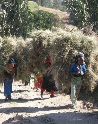
'Cut and Carry' Grazing system or 'Zero Grazing' … [Ethiopia]
Cut and carry grazing system (alternatively called zero grazing) is an approach where the community is consulted to identify and agree on areas to be closed and protected from free grazing; establish user groups are established to share the fodder biomass harvested from communal closed areas equitably; they utilize tree/shrub …
- Compiler: Gizaw Desta Gessesse
2. Description of the SLM Technology
2.1 Short description of the Technology
Definition of the Technology:
Area closure on degraded lands is a land management practice used to rehabilitate and conserve the natural resource bases, and enhance its natural regeneration and restoring capacity and productive functions by excluding animal and human interferences through community consultation and collective actions.
2.2 Detailed description of the Technology
Description:
Area closure is a land management practice that helps to rehabilitate degraded lands, restore the biophysical conditions like soil, vegetation and hydrology by avoiding the interference of animals and human. Because of over grazing and erosion impact, areas delineated for closure are usually degraded shrub or pasture lands that served for grazing. First of all, implementing area closure requires continuous dialogue and discussion with community to reach consensus to close. The community wants to make sure they have benefited from the technology as the land was serving for grazing. They should take the responsibility and create sense of ownership to implement conservation measures, protect and maintain closure areas, and regulate utilization of benefits gained out of it. Questions raised from the community must be discussed thoroughly ahead of the implementation. What part of the degraded land? For what purpose the area is closed? Who are the users? Who are responsible to protect and manage the developed resourcess? How is the benefit sharing among identified users? Commonly, the shared benefits from area closures are hay for livestock through cut-and-carry system, timbers from plantations, and honey production.
Depending on the soil, rainfall and slope conditions different structural and vegetative measures are integrated to enhance the fast regeneration of plant species, restore the soil and increase water availability. It includes enrichment used to rehabilitate and increase the vegetation cover, vegetative and structural measures to retain the soil and water on its place. Structures such as hillside terrace often integrated with grass or shrub hedgerows is used to control soil erosion. In-situ water harvesting structures such as trenches or half moon or eye brow are used to harvest and infiltrate rain or runoff water to increase regeneration and survival of planted trees. Trees and/or shrub species that have high rehabilitation and multipurpose values are used as enrichment plantations. Closed areas need collective action to protect, maintain and manage the common resources. Collective user rights have to be entitled to bring equity on resource sharing and minimize social conflicts.
The purposes of area closure are: 1) rehabilitate degraded lands, 2) protect and restore the natural resource base, and 3) change into productive land and enhance economic and environmental functions of rehabilitated lands.
Implementation of area closure begins with the selection and demarcation of area through genuine participation of land users. After identifying the area to be closed, at establishment stage construction of ditches and terraces is made using stones combined with grasses or shrubs of multipurpose value such as Vetiver grass, Dinsho grass, Bana grass, susbania, etc. Depending on site conditions, enrichment tree species which have rehabilitation and soil restoration purposes are planted in the form of wood lot or scattered tree plantation. Among the common species, A. albida, A. saligna, A. decurrense, Gravilia robusta, etc. are used to rehabilitate and serve as fuel wood and timber. In moisture stress areas structures like trench, level bunds, and half moon should be constructed to increase survival rate of planted tree/shrub species whereas in areas having sufficient moisture these structures, depending on the landforms and soil drainage conditions, help to increase infiltration and recharging of ground water in downstream areas. Therefore, site selection and demarcation, construction of soil conservation and moisture conservation structures, and seedling management and plantation of multipurpose trees, shrubs and grasses are the activities accomplished at establishment stage of area closure. The required inputs are stones, seeds/seedlings, grass cuttings/splits, hand tools, and collective labor. For recurrent maintenance activities, seedlings and cuttings for re-plantation purpose or replace dead seedlings, stones to repair damage stone terraces and moisture conservation structures. Harvesting and transporting of area closure products such as grass and timber become a recurrent activity. Person days per hectare per year required for plantation (preparation of holes and planting) is 11.5, for harvesting and transporting harvested grass is 30, and for terrace construction is 26.5.
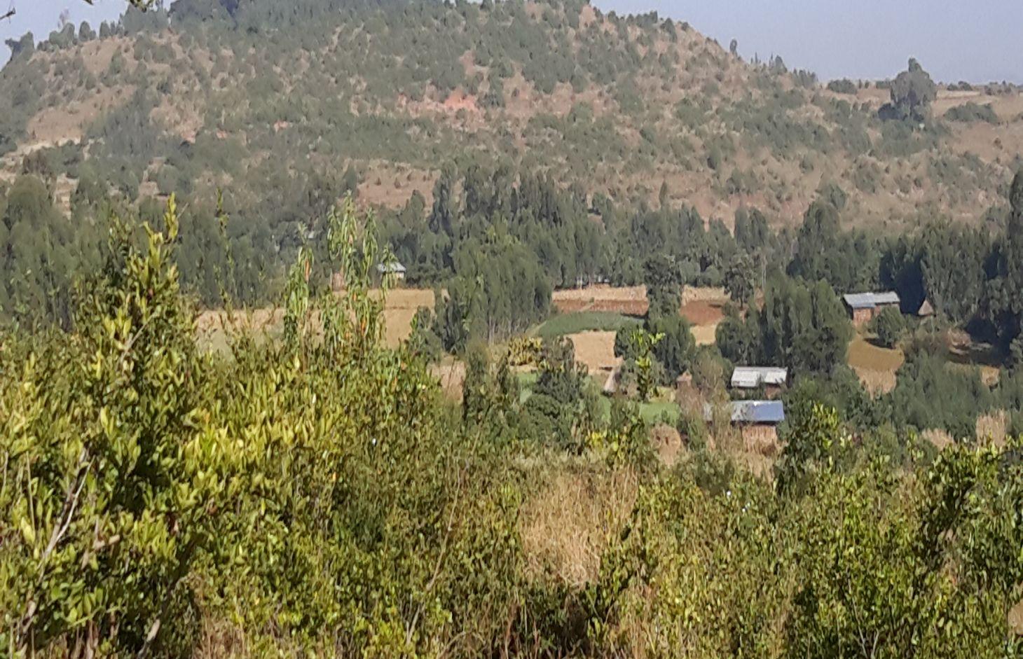
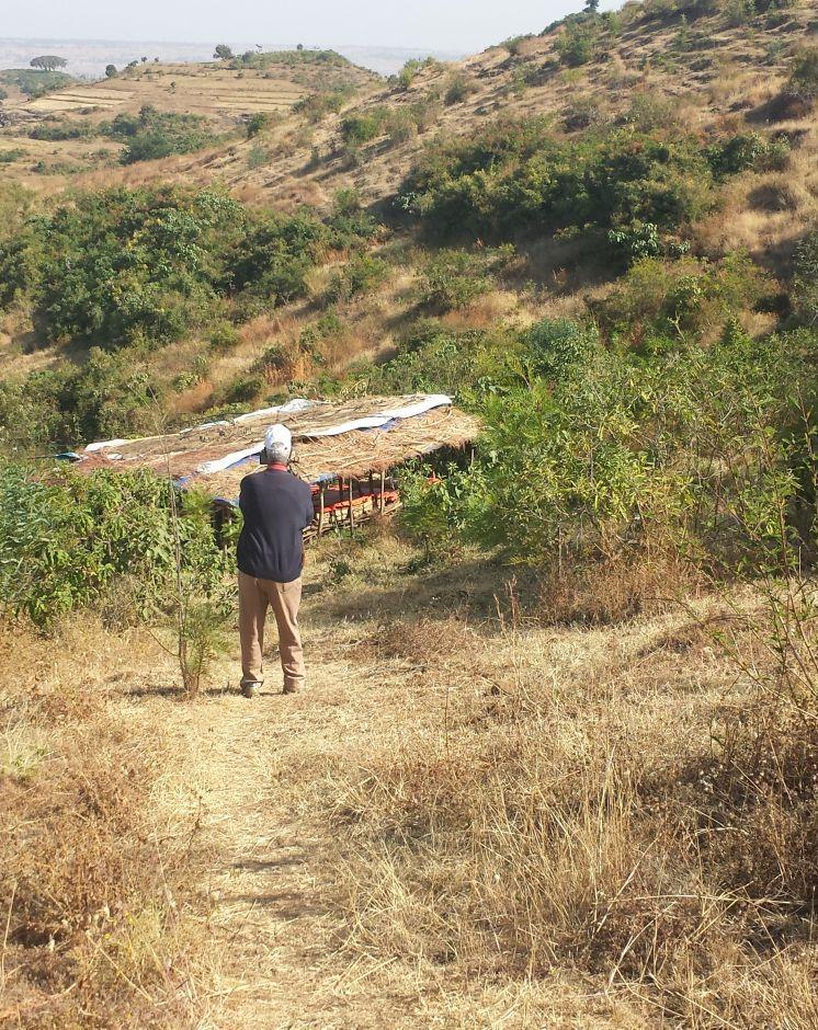
Area closure management is commonly practiced on degraded hills where soil is highly depleted, its water holding capacity is low, and vegetation is denuded. Usually degraded lands are used to serve for communal grazing system. The degree of land degradation becomes severe where there are high livestock and human population pressure. Management of closure area and the benefit sharing has to be regulated using agreed bylaws.
The living condition depends on subsistence crop-livestock mixed farming. On average households have 5-6 family size. Crop production is meant for home consumption with small surplus for local market. The services related to water supply, energy supply, and infrastructure are low. Besides it is an asset, animals often used to cope shocks during drought periods.
2.3 Photos of the Technology
Media Gallery
2.5 Country/ region/ locations where the Technology has been applied and which are covered by this assessment
Country:
Ethiopia
Region/ State/ Province:
Amhara National Regional State
Further specification of location:
Mecha / Yilmana Densa / Bahir Dar Zuria
Specify the spread of the Technology:
- evenly spread over an area
If precise area is not known, indicate approximate area covered:
- 1-10 km2
2.6 Date of implementation
If precise year is not known, indicate approximate date:
- less than 10 years ago (recently)
2.7 Introduction of the Technology
Specify how the Technology was introduced:
- through projects/ external interventions
Comments (type of project, etc.):
Area closure as an integrated SLM technology is practiced in recent years. However, the land users have their own traditional practice by closing grass lands or shrub lands during the rainy season.
3. Classification of the SLM Technology
3.1 Main purpose(s) of the Technology
- conserve ecosystem
3.2 Current land use type(s) where the Technology is applied
Land use mixed within the same land unit:
Ja
Specify mixed land use (crops/ grazing/ trees):
- Agro-pastoralism (incl. integrated crop-livestock)

Cropland
- Perennial (non-woody) cropping
- Tree and shrub cropping
- Vetiver grass, Dinsho grass, Bana grass, susbania
- A. albida, A. saligna, A. decurrense, Gravilia robusta, napier
Number of growing seasons per year:
- 1
Specify:
Longest growing period in days: 220, Longest growing period from month to month: May to December; Second longest growing period in days: 180, Second longest growing period from month to month: June to November

Grazing land
Extensive grazing:
- Semi-nomadic pastoralism
Intensive grazing/ fodder production:
- Cut-and-carry/ zero grazing

Forest/ woodlands
Products and services:
- Timber
- Fuelwood
- Grazing/ browsing
Comments:
Livestock density (if relevant):
> 100 LU /km2
Major land use problems (compiler’s opinion): Land degradation due to different forms of soil erosion and nutrient depletion, excess removal of crop residues, excessive overgrazing, shortage of pasture lands and its low productivity, excessive and inappropriate construction of traditional ditches, and increased demand of trees for the purpose of fuel wood and timber.
Major land use problems (land users’ perception): Soil erosion and soil nutrient depletion, shortage of cultivated land, shortage of grazing land and wood for fuel wood
3.4 Water supply
Water supply for the land on which the Technology is applied:
- rainfed
3.5 SLM group to which the Technology belongs
- area closure (stop use, support restoration)
3.6 SLM measures comprising the Technology

vegetative measures
- V1: Tree and shrub cover
- V2: Grasses and perennial herbaceous plants

structural measures
- S2: Bunds, banks
- S3: Graded ditches, channels, waterways
- S4: Level ditches, pits

management measures
- M1: Change of land use type
- M2: Change of management/ intensity level
Comments:
Type of vegetative measures: aligned: -contour, scattered / dispersed, in blocks
3.7 Main types of land degradation addressed by the Technology

soil erosion by water
- Wt: loss of topsoil/ surface erosion
- Wo: offsite degradation effects

chemical soil deterioration
- Cn: fertility decline and reduced organic matter content (not caused by erosion)

biological degradation
- Bc: reduction of vegetation cover
- Bh: loss of habitats
Comments:
Main causes of degradation: deforestation / removal of natural vegetation (incl. forest fires), overgrazing, population pressure, governance / institutional
Secondary causes of degradation: soil management, over-exploitation of vegetation for domestic use, Heavy / extreme rainfall (intensity/amounts), land tenure, education, access to knowledge and support services
3.8 Prevention, reduction, or restoration of land degradation
Specify the goal of the Technology with regard to land degradation:
- reduce land degradation
- restore/ rehabilitate severely degraded land
4. Technical specifications, implementation activities, inputs, and costs
4.1 Technical drawing of the Technology
Technical specifications (related to technical drawing):
Integrated practices of area closure including hillside bunds, trenches, micro-basins, and trees/shrubs
Location: Debre Yacob Learning Watershed. Mecha/West Gojam/Amhara
Date: 2014-5-23
Technical knowledge required for field staff / advisors: moderate (Field staffs need to acquire technical knowledge on how to integrate different practices and strategies depending on the conditions and degree of degradation.)
Technical knowledge required for land users: low (Land users require low knowledge. Once they implement practices in the closure area, they are able to coordinate and respect the bylaws and equitable distribution of benefits.)
Main technical functions: control of raindrop splash, control of dispersed runoff: retain / trap, control of concentrated runoff: impede / retard, improvement of ground cover, increase of biomass (quantity)
Secondary technical functions: control of concentrated runoff: drain / divert, improvement of topsoil structure (compaction), increase in organic matter, increase / maintain water stored in soil
Aligned: -contour
Vegetative material: T : trees / shrubs, G : grass
Number of plants per (ha): 4000-6000
Spacing between rows / strips / blocks (m): 5
Vertical interval within rows / strips / blocks (m): 0.5-1.0
Width within rows / strips / blocks (m): 0.5
Scattered / dispersed
Vegetative material: T : trees / shrubs
Number of plants per (ha): 160
In blocks
Vegetative material: T : trees / shrubs
Spacing between rows / strips / blocks (m): 2
Vertical interval within rows / strips / blocks (m): 2
Trees/ shrubs species: Gravilia, Susbania, Acacia decurrence
Grass species: Napier
Slope (which determines the spacing indicated above): 20-30%
Gradient along the rows / strips: 0.5%
Diversion ditch/ drainage
Depth of ditches/pits/dams (m): 0.3-0.7
Width of ditches/pits/dams (m): 1.2-2.8
Length of ditches/pits/dams (m): 100-250
Waterway
Depth of ditches/pits/dams (m): 0.3
Width of ditches/pits/dams (m): 1.5-2.0
Bund/ bank: level
Spacing between structures (m): 5
Height of bunds/banks/others (m): 0.5
Width of bunds/banks/others (m): 1-1.5
Slope (which determines the spacing indicated above): 15-35%
Vegetation is used for stabilisation of structures.
Change of land use type: Initially, the land is highly degraded and waste land. After an increase in vegetation cover and biomass, its use is thus changed from waste/shrub land/open grazing to cut-and-carry grazing system
Change of land use practices / intensity level: The land use management is changed from open access /communal grazing or shrub land to regulated or organized form of land use management
Author:
Bekure Melese, WLRC
4.2 General information regarding the calculation of inputs and costs
other/ national currency (specify):
ETB
If relevant, indicate exchange rate from USD to local currency (e.g. 1 USD = 79.9 Brazilian Real): 1 USD =:
20.0
Indicate average wage cost of hired labour per day:
2.50
4.3 Establishment activities
| Activity | Timing (season) | |
|---|---|---|
| 1. | Preparation of seedlings | March-May |
| 2. | Transporting seedlings | July |
| 3. | Transporting grass splits | July |
| 4. | Sowing seeds on bunds | July |
| 5. | Planting of trees and shrubs | July |
| 6. | Planting of grass splits or cuttings | July |
| 7. | Construction of bunds or terraces | February-April |
| 8. | Construction of cutoff drains and ditches | Fegruary-April |
| 9. | Construction of waterways | February-April |
| 10. | Surveying or layout of structures | January-March |
| 11. | Consultation of the community | |
| 12. | Establish bylaws to control free grazing | |
| 13. | Establish user groups and arrange equitable benefit sharing |
4.4 Costs and inputs needed for establishment
| Specify input | Unit | Quantity | Costs per Unit | Total costs per input | % of costs borne by land users | |
|---|---|---|---|---|---|---|
| Labour | labour | ha | 1.0 | 1766.0 | 1766.0 | 80.0 |
| Equipment | tools | ha | 1.0 | 300.6 | 300.6 | 50.0 |
| Plant material | seedlings | ha | 1.0 | 405.6 | 405.6 | 100.0 |
| Plant material | seeds | ha | 1.0 | 20.0 | 20.0 | 100.0 |
| Construction material | stone | ha | 1.0 | 1300.0 | 1300.0 | 100.0 |
| Total costs for establishment of the Technology | 3792.2 | |||||
| Total costs for establishment of the Technology in USD | 189.61 | |||||
Comments:
Duration of establishment phase: 15 month(s)
4.5 Maintenance/ recurrent activities
| Activity | Timing/ frequency | |
|---|---|---|
| 1. | Preparation of seedlings | March-May |
| 2. | Seedling transportation | July |
| 3. | Grass split transportation | July |
| 4. | Planting seedlings | July |
| 5. | Planting grass splits | July |
| 6. | Maintenance of bunds / cutoff drains | |
| 7. | Enforcing bylaws | Throught the year |
| 8. | Benefit sharing among user groups | Throughout the year |
4.6 Costs and inputs needed for maintenance/ recurrent activities (per year)
| Specify input | Unit | Quantity | Costs per Unit | Total costs per input | % of costs borne by land users | |
|---|---|---|---|---|---|---|
| Labour | labour | ha | 1.0 | 624.0 | 624.0 | 29.0 |
| Plant material | seedlings | ha | 1.0 | 250.0 | 250.0 | 100.0 |
| Total costs for maintenance of the Technology | 874.0 | |||||
| Total costs for maintenance of the Technology in USD | 43.7 | |||||
Comments:
Machinery/ tools: Spade, pickaxe, crowbar,
4.7 Most important factors affecting the costs
Describe the most determinate factors affecting the costs:
The costs of area closure affected by the labour availability, regeneration capacity of trees on the degraded lands
5. Natural and human environment
5.1 Climate
Annual rainfall
- < 250 mm
- 251-500 mm
- 501-750 mm
- 751-1,000 mm
- 1,001-1,500 mm
- 1,501-2,000 mm
- 2,001-3,000 mm
- 3,001-4,000 mm
- > 4,000 mm
Agro-climatic zone
- sub-humid
Thermal climate class: subtropics
5.2 Topography
Slopes on average:
- flat (0-2%)
- gentle (3-5%)
- moderate (6-10%)
- rolling (11-15%)
- hilly (16-30%)
- steep (31-60%)
- very steep (>60%)
Landforms:
- plateau/plains
- ridges
- mountain slopes
- hill slopes
- footslopes
- valley floors
Altitudinal zone:
- 0-100 m a.s.l.
- 101-500 m a.s.l.
- 501-1,000 m a.s.l.
- 1,001-1,500 m a.s.l.
- 1,501-2,000 m a.s.l.
- 2,001-2,500 m a.s.l.
- 2,501-3,000 m a.s.l.
- 3,001-4,000 m a.s.l.
- > 4,000 m a.s.l.
5.3 Soils
Soil depth on average:
- very shallow (0-20 cm)
- shallow (21-50 cm)
- moderately deep (51-80 cm)
- deep (81-120 cm)
- very deep (> 120 cm)
Soil texture (topsoil):
- medium (loamy, silty)
- fine/ heavy (clay)
Topsoil organic matter:
- low (<1%)
5.4 Water availability and quality
Ground water table:
> 50 m
Availability of surface water:
medium
Water quality (untreated):
poor drinking water (treatment required)
5.5 Biodiversity
Species diversity:
- low
5.6 Characteristics of land users applying the Technology
Market orientation of production system:
- subsistence (self-supply)
Off-farm income:
- less than 10% of all income
Relative level of wealth:
- poor
- average
Individuals or groups:
- groups/ community
Gender:
- women
- men
Indicate other relevant characteristics of the land users:
Land users applying the Technology are mainly common / average land users
Difference in the involvement of women and men: Women has their own role in the establishment of the rea closure by collecting stones, support construction and planting activities. In addition they will harvest and transport fodder for livestock
Population density: 200-500 persons/km2
Annual population growth: 2% - 3%
80% of the land users are average wealthy.
20% of the land users are poor.
5.7 Average area of land used by land users applying the Technology
- < 0.5 ha
- 0.5-1 ha
- 1-2 ha
- 2-5 ha
- 5-15 ha
- 15-50 ha
- 50-100 ha
- 100-500 ha
- 500-1,000 ha
- 1,000-10,000 ha
- > 10,000 ha
Is this considered small-, medium- or large-scale (referring to local context)?
- small-scale
5.8 Land ownership, land use rights, and water use rights
Land ownership:
- state
Water use rights:
- open access (unorganized)
- communal (organized)
5.9 Access to services and infrastructure
health:
- poor
- moderate
- good
education:
- poor
- moderate
- good
technical assistance:
- poor
- moderate
- good
employment (e.g. off-farm):
- poor
- moderate
- good
markets:
- poor
- moderate
- good
energy:
- poor
- moderate
- good
roads and transport:
- poor
- moderate
- good
drinking water and sanitation:
- poor
- moderate
- good
financial services:
- poor
- moderate
- good
6. Impacts and concluding statements
6.1 On-site impacts the Technology has shown
Socio-economic impacts
Production
fodder production
Comments/ specify:
Mainly serve for grass harvest
animal production
Comments/ specify:
Cut and carry improve the production
production area
Comments/ specify:
By improving the land use management, production area for pasture increased
Income and costs
diversity of income sources
Comments/ specify:
People try to diverse apiculture production in closed areas
workload
Comments/ specify:
Labor requirement to harvest and transport fodder and pasture increase
Socio-cultural impacts
community institutions
Comments/ specify:
Establishment of user groups and watershed users association
SLM/ land degradation knowledge
Comments/ specify:
Increase the level of awareness that area closure can shortly reverse land degradation
conflict mitigation
Comments/ specify:
Reduce conflict arise due to pasture shortage
situation of socially and economically disadvantaged groups
Comments/ specify:
Some rural unemployed youths get employed in apiculture production and fruit production
contribution to human well-being
Comments/ specify:
The livestock production is moderately improved due to increase in biomass/ pasture harvest
Ecological impacts
Water cycle/ runoff
water quantity
surface runoff
groundwater table/ aquifer
Soil
soil moisture
soil cover
soil loss
Biodiversity: vegetation, animals
biomass/ above ground C
plant diversity
habitat diversity
Climate and disaster risk reduction
fire risk
6.2 Off-site impacts the Technology has shown
reliable and stable stream flows in dry season
Quantity before SLM:
End of Nov
Quantity after SLM:
Mar-April
Comments/ specify:
Because of high vegetation cover, the recharrging capacity improved resulting in prolonging the stream flow/baseflow
downstream flooding
downstream siltation
6.3 Exposure and sensitivity of the Technology to gradual climate change and climate-related extremes/ disasters (as perceived by land users)
Climate-related extremes (disasters)
Meteorological disasters
| How does the Technology cope with it? | |
|---|---|
| local rainstorm | well |
Climatological disasters
| How does the Technology cope with it? | |
|---|---|
| drought | well |
Hydrological disasters
| How does the Technology cope with it? | |
|---|---|
| general (river) flood | not well |
6.4 Cost-benefit analysis
How do the benefits compare with the establishment costs (from land users’ perspective)?
Short-term returns:
slightly positive
Long-term returns:
positive
How do the benefits compare with the maintenance/ recurrent costs (from land users' perspective)?
Short-term returns:
positive
Long-term returns:
very positive
Comments:
Short term economic benefits can be attained by harvesting forage biomass for livestock while in the long term downstream agricultural productivity can be improved as they witnessed the change in stream flows to be used for irrigation. This is very much pronounced in Aba Gerima watershed where farmers in the downstream get to access more water.
6.5 Adoption of the Technology
Comments:
The technology is implemented in group or at community level.
The spontaneous adoption of this technology is possible without integrating plantations of improved trees/shrubs and grasses
There is a moderate trend towards spontaneous adoption of the Technology
Adoption to area closure is increasing as it provides better pasture for livestock and benefit those who do not have power or for poor community groups
6.7 Strengths/ advantages/ opportunities of the Technology
| Strengths/ advantages/ opportunities in the land user’s view |
|---|
| Increase in vegetation cover and biomass production for livestock feed |
| Increase the duration and flow of streams |
| Decrease erosion |
| Decrease transmission of animal disease often a problem during open grazing system |
| Strengths/ advantages/ opportunities in the compiler’s or other key resource person’s view |
|---|
| Increase the fodder and grass biomass production for livestock feed |
| Increase the regeneration of lost plant diversities |
| Create alternative livelihood options (off farm activities like honey production, timber, tree or fodder seed production) |
| Enhance the micro-climatic conditions and on-site vegetation cover, organic matter, and soil water holding capacity. In addition it improves off-site surface and subsurface water flows |
6.8 Weaknesses/ disadvantages/ risks of the Technology and ways of overcoming them
| Weaknesses/ disadvantages/ risks in the land user’s view | How can they be overcome? |
|---|---|
| Land users' perceived that implementation of the technology decreases open access to communal pasture lands to maximize their benefit | Awareness creation activities has to be provided |
| Shortage of labor to harvest and transport forages to feed animals | Cost effective technologies to prepare feed, handle and transport forage has to be introduced and adopted. It can be overcomed by organizing service provider groups. |
| The amount of pasture/fodder produced and shared among users is much less than the feed requirement of all animals hold by a household | Introduce fodder species producing high biomass and high quality fodder; decrease livestock number per household. |
| Weaknesses/ disadvantages/ risks in the compiler’s or other key resource person’s view | How can they be overcome? |
|---|---|
| Labor constraint for cut-and -carry for stall feeding | It can be sustained through organizing service providers groups |
| Stall feeding restricted the cross breeding of animals in the village easily accessible during open grazing | Artificial insemination and bull services and synchronization breeding system has to be promoted |
7. References and links
7.1 Methods/ sources of information
- field visits, field surveys
- interviews with land users
7.2 References to available publications
Title, author, year, ISBN:
Sustaining the win-win benefits of improved grazing land management in EthiopiaPost written by Wolde Mekuria, WLE. March 30, 2015
Available from where? Costs?
WLE post
Title, author, year, ISBN:
http://www.bioone.org/doi/pdf/10.1659/0276-4741(2005)025%5B0044%3ATROCIC%5D2.0.CO%3B2
Title, author, year, ISBN:
Vegetation Improvement in Communal Closed Areas in Tigray, Ethiopia.Sarah Tewolde-Berhan 1,4, Ralph Mitlöhner 2, Bart Muys3 , and Mitiku Haile 4
Title, author, year, ISBN:
Natural Regeneration Practice in Degraded High Lands of Ethiopia Through Area Enclosure Wondie Mebrat, Department of Biology, Adigrat University, Adigrat, Tigray, Ethiopia, 2015
Title, author, year, ISBN:
Area Closure: Rehabilitation of Degraded Lands and Grasslands and its Multiple Benefits. WLRC Brief No. 2. June 2015
Available from where? Costs?
www.wlrc-eth.org
Links and modules
Expand all Collapse allLinks
'Cut and Carry' Grazing system or 'Zero Grazing' … [Ethiopia]
Cut and carry grazing system (alternatively called zero grazing) is an approach where the community is consulted to identify and agree on areas to be closed and protected from free grazing; establish user groups are established to share the fodder biomass harvested from communal closed areas equitably; they utilize tree/shrub …
- Compiler: Gizaw Desta Gessesse
Modules
No modules