Brush Layering [Lesotho]
- Creation:
- Update:
- Compiler: Matoka Moshoeshoe
- Editor: –
- Reviewers: Rima Mekdaschi Studer, William Critchley
Brush packs
technologies_4594 - Lesotho
View sections
Expand all Collapse all1. معلومات عامة
1.2 Contact details of resource persons and institutions involved in the assessment and documentation of the Technology
Key resource person(s)
SLM specialist:
Name of project which facilitated the documentation/ evaluation of the Technology (if relevant)
Decision Support for Mainstreaming and Scaling out Sustainable Land Management (GEF-FAO / DS-SLM)Name of the institution(s) which facilitated the documentation/ evaluation of the Technology (if relevant)
Integrated Catchment Management Project (Integrated Catchment Management Project) - Lesotho1.3 Conditions regarding the use of data documented through WOCAT
The compiler and key resource person(s) accept the conditions regarding the use of data documented through WOCAT:
نعم
1.4 Declaration on sustainability of the described Technology
Is the Technology described here problematic with regard to land degradation, so that it cannot be declared a sustainable land management technology?
لا
Comments:
This technology is environmentally sustainable
1.5 Reference to Questionnaire(s) on SLM Approaches (documented using WOCAT)
Enhancement of existing SLM technologies into demonstration sites [Tajikistan]
Enhancement of existing self developed SLM technologies into demonstration sites.
- Compiler: Habib Kamolidinov
2. Description of the SLM Technology
2.1 Short description of the Technology
Definition of the Technology:
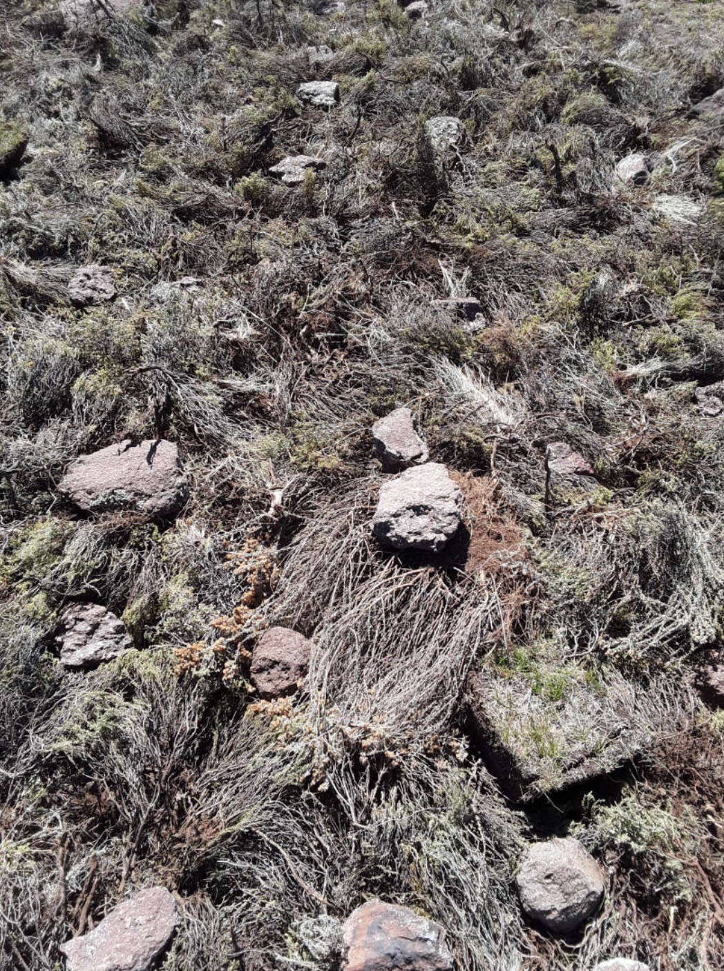
The technology requires removal of invaders as resources for layering. The technology enhances accumulation of silt and moisture storage in dry-lands due to increased organic matter content in the soil from the brush.
2.2 Detailed description of the Technology
Description:
DESCRIPTION OF TECHNOLOGY
1. It is applied on bare lands
2. Flowering stages of invaders should be taken into consideration before layering
3. functions; silt trap, moisture retention, as a factor of soil formation and medium for plant growth
4. Locally available materials such as invasive species
5. Improves land cover, land productivity and soil organic carbon
6. To land users, the technology is easy to implement and it has higher chances of reclaiming the marginal land. However, most of invasive species are used as source of fuel by the rural communities for cooking and heating in households. Many rural communities do not have electricity, gas or firewood as a source of fuel. Whenever people come across a heap of these invasive species, they vandalize it.
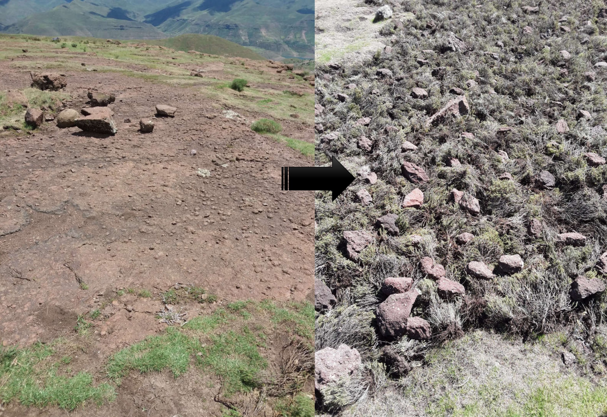
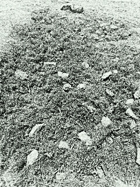
2.3 Photos of the Technology
Media Gallery
General remarks regarding photos:
Photos were captured during summer season when invasive species were prominent
2.4 Videos of the Technology
Comments, short description:
N/A
الموقع:
N/A
Name of videographer:
N/A
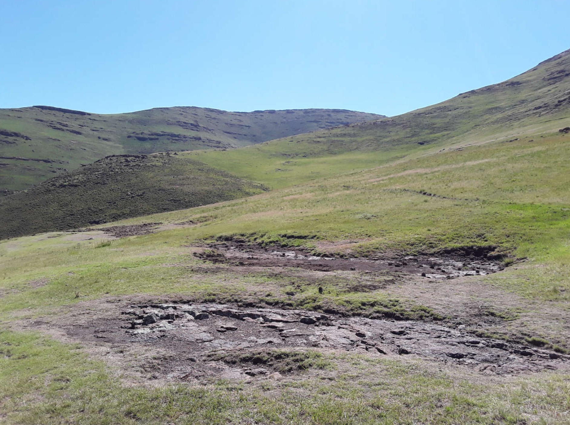
2.5 Country/ region/ locations where the Technology has been applied and which are covered by this assessment
بلد:
Lesotho
Region/ State/ Province:
Leribe District
Further specification of location:
Lesotho highlands
Specify the spread of the Technology:
- applied at specific points/ concentrated on a small area
Is/are the technology site(s) located in a permanently protected area?
لا
Comments:
all forms of biodiversity were reclaimed since the implementation of the technology
Map
×2.6 Date of implementation
Indicate year of implementation:
2019
2.7 Introduction of the Technology
Specify how the Technology was introduced:
- through projects/ external interventions
Comments (type of project, etc.):
The technology was advocated to the community during scaling out of DS-SLM project
3. Classification of the SLM Technology
3.1 Main purpose(s) of the Technology
- improve production
- reduce, prevent, restore land degradation
- conserve ecosystem
- protect a watershed/ downstream areas – in combination with other Technologies
- preserve/ improve biodiversity
3.2 Current land use type(s) where the Technology is applied
Land use mixed within the same land unit:
لا

أراضي الرعي
Extensive grazing:
- Semi-nomadic pastoralism
Intensive grazing/ fodder production:
- Improved pastures
Animal type:
- cattle - non-dairy beef
Is integrated crop-livestock management practiced?
نعم
If yes, specify:
Maize, peas and wheat
Products and services:
- meat
- transport/ draught
Species:
cattle - non-dairy working
Comments:
more than 80% of the area is range-land. The area forms part of the upper catchment for the Katse dam (LHDA)
3.3 Has land use changed due to the implementation of the Technology?
Has land use changed due to the implementation of the Technology?
- No (Continue with question 3.4)
3.4 Water supply
Water supply for the land on which the Technology is applied:
- rainfed
Comments:
The technology is implemented on the range-land
3.5 SLM group to which the Technology belongs
- integrated crop-livestock management
3.6 SLM measures comprising the Technology

vegetative measures
- V2: Grasses and perennial herbaceous plants
- V4: Replacement or removal of alien/ invasive species

management measures
- M5: Control/ change of species composition
Comments:
The technology improves acreage and range-land health
3.7 Main types of land degradation addressed by the Technology

soil erosion by water
- Wt: loss of topsoil/ surface erosion

soil erosion by wind
- Et: loss of topsoil

physical soil deterioration
- Pk: slaking and crusting
- Pi: soil sealing

biological degradation
- Bc: reduction of vegetation cover
- Bh: loss of habitats
- Bq: quantity/ biomass decline
- Bl: loss of soil life

water degradation
- Hp: decline of surface water quality
Comments:
Improves land cover quality and productivity
3.8 Prevention, reduction, or restoration of land degradation
Specify the goal of the Technology with regard to land degradation:
- reduce land degradation
- restore/ rehabilitate severely degraded land
Comments:
It is very effective as a means to control land degradation - LDN indicators; Land cover, Land productivity and Soil organic carbon can be achieved through this technology
4. Technical specifications, implementation activities, inputs, and costs
4.1 Technical drawing of the Technology
Technical specifications (related to technical drawing):
There is no criteria on how to construct the brush packs, the brush/invaders are uprooted from somewhere, whether within the same area or transported from another area, what is important is that any bare land within the catchment is applied this technology. The brush is simply placed on any area that has no vegetative cover, and stones are put on top of the brush so as to avoid being blown away by the wind. There is no specific design for this technology. As a result, there cannot be any technical drawing for this technology.
Author:
Koetlisi Koetlisi
Date:
20/02/2019
4.2 General information regarding the calculation of inputs and costs
Specify how costs and inputs were calculated:
- per Technology area
Indicate size and area unit:
0.25ha
If using a local area unit, indicate conversion factor to one hectare (e.g. 1 ha = 2.47 acres): 1 ha =:
N/A
Specify currency used for cost calculations:
- USD
Indicate average wage cost of hired labour per day:
4.6
4.3 Establishment activities
| Activity | Timing (season) | |
|---|---|---|
| 1. | public gathering | Any |
| 2. | brush control | before flowering |
| 3. | brush layering | Any |
Comments:
The brush is uprooted then put as it is onto the bare soil, the rest is done is done by insects and micro-organisms
It is important to consider flowering season of invaders in order to avoid anthropogenic dispersal of seeds
4.4 Costs and inputs needed for establishment
| Specify input | Unit | Quantity | Costs per Unit | Total costs per input | % of costs borne by land users | |
|---|---|---|---|---|---|---|
| Labour | person-days | 1,0 | 5,0 | 5,0 | 5,0 | |
| Equipment | muttock | piece | 1,0 | 16,0 | 16,0 | |
| Total costs for establishment of the Technology | 21,0 | |||||
| Total costs for establishment of the Technology in USD | 21,0 | |||||
If you are unable to break down the costs in the table above, give an estimation of the total costs of establishing the Technology:
21,0
If land user bore less than 100% of costs, indicate who covered the remaining costs:
Government
Comments:
This technology is free, nothing is procured in order to implement it. The communities alone do implement by themselves.
With or without government funds, the activity can still be implemented
4.5 Maintenance/ recurrent activities
| Activity | Timing/ frequency | |
|---|---|---|
| 1. | N/A | N/A |
Comments:
One way to maintain this technology is re-layering where the first attempt was not successful.
Periodic visits required in order to check re-growth of invaders as well as expected species
4.6 Costs and inputs needed for maintenance/ recurrent activities (per year)
| Specify input | Unit | Quantity | Costs per Unit | Total costs per input | % of costs borne by land users | |
|---|---|---|---|---|---|---|
| Labour | N/A | N/A |
If land user bore less than 100% of costs, indicate who covered the remaining costs:
Government
Comments:
The activity requires minimal effort and less funds to be performed although the yields are very high
4.7 Most important factors affecting the costs
Describe the most determinate factors affecting the costs:
The technology is a free one, anybody even a layman does implement it. Herders at cattle post do implement it. There are no costs incurred to implement it.
The implementation as well as maintenance are least cost effective
5. Natural and human environment
5.1 Climate
Annual rainfall
- < 250 mm
- 251-500 mm
- 501-750 mm
- 751-1,000 mm
- 1,001-1,500 mm
- 1,501-2,000 mm
- 2,001-3,000 mm
- 3,001-4,000 mm
- > 4,000 mm
Specify average annual rainfall (if known), in mm:
1200,00
Specifications/ comments on rainfall:
Lesotho highlands receive generally very good rains
Indicate the name of the reference meteorological station considered:
Bokong
Agro-climatic zone
- semi-arid
Lesotho is generally on temperate zones
5.2 Topography
Slopes on average:
- flat (0-2%)
- gentle (3-5%)
- moderate (6-10%)
- rolling (11-15%)
- hilly (16-30%)
- steep (31-60%)
- very steep (>60%)
Landforms:
- plateau/plains
- ridges
- mountain slopes
- hill slopes
- footslopes
- valley floors
Altitudinal zone:
- 0-100 m a.s.l.
- 101-500 m a.s.l.
- 501-1,000 m a.s.l.
- 1,001-1,500 m a.s.l.
- 1,501-2,000 m a.s.l.
- 2,001-2,500 m a.s.l.
- 2,501-3,000 m a.s.l.
- 3,001-4,000 m a.s.l.
- > 4,000 m a.s.l.
Indicate if the Technology is specifically applied in:
- not relevant
Comments and further specifications on topography:
It is easily implemented on gently to moderate slopes
5.3 Soils
Soil depth on average:
- very shallow (0-20 cm)
- shallow (21-50 cm)
- moderately deep (51-80 cm)
- deep (81-120 cm)
- very deep (> 120 cm)
Soil texture (topsoil):
- medium (loamy, silty)
Soil texture (> 20 cm below surface):
- medium (loamy, silty)
Topsoil organic matter:
- low (<1%)
If available, attach full soil description or specify the available information, e.g. soil type, soil PH/ acidity, Cation Exchange Capacity, nitrogen, salinity etc.
Detailed soil depth, type and texture map could be found on https;//lesis.gov.ls
5.4 Water availability and quality
Ground water table:
< 5 m
Availability of surface water:
good
Water quality (untreated):
good drinking water
Water quality refers to:
both ground and surface water
Is water salinity a problem?
لا
Is flooding of the area occurring?
لا
Comments and further specifications on water quality and quantity:
Water quality is attributed to good range-land management as the erosion is minimal as well as parent rock
5.5 Biodiversity
Species diversity:
- high
Habitat diversity:
- high
Comments and further specifications on biodiversity:
Most areas still have good biodiversity especially where range-lands are rested
5.6 Characteristics of land users applying the Technology
Sedentary or nomadic:
- Semi-nomadic
Market orientation of production system:
- mixed (subsistence/ commercial)
Off-farm income:
- 10-50% of all income
Relative level of wealth:
- average
Individuals or groups:
- individual/ household
- groups/ community
Level of mechanization:
- manual work
- animal traction
Gender:
- women
- men
Age of land users:
- middle-aged
- elderly
Indicate other relevant characteristics of the land users:
The land users are very cooperative together with their local authorities in land management activities
5.7 Average area of land used by land users applying the Technology
- < 0.5 ha
- 0.5-1 ha
- 1-2 ha
- 2-5 ha
- 5-15 ha
- 15-50 ha
- 50-100 ha
- 100-500 ha
- 500-1,000 ha
- 1,000-10,000 ha
- > 10,000 ha
Is this considered small-, medium- or large-scale (referring to local context)?
- small-scale
Comments:
The technology is yet to be up-scaled as this was just a demonstration site
5.8 Land ownership, land use rights, and water use rights
Land ownership:
- communal/ village
- individual, titled
Land use rights:
- open access (unorganized)
- communal (organized)
Water use rights:
- open access (unorganized)
- communal (organized)
Are land use rights based on a traditional legal system?
نعم
Comments:
In Lesotho, land is communally owned therefore, all land users have access to the communal land, no user rights are given, that is why there is common pool resources challenges. communities manage their resources by laying down regulations and bylaws.
Lesotho land tenure system supports communal ownership of land
5.9 Access to services and infrastructure
health:
- poor
- moderate
- good
education:
- poor
- moderate
- good
technical assistance:
- poor
- moderate
- good
employment (e.g. off-farm):
- poor
- moderate
- good
markets:
- poor
- moderate
- good
energy:
- poor
- moderate
- good
roads and transport:
- poor
- moderate
- good
drinking water and sanitation:
- poor
- moderate
- good
financial services:
- poor
- moderate
- good
Comments:
Unlike most highlands in Lesotho, this area is most privileged due to Lesotho Highlands Development Authority interventions
6. Impacts and concluding statements
6.1 On-site impacts the Technology has shown
Socio-economic impacts
Production
land management
Quantity before SLM:
Degraded land
Quantity after SLM:
Restoration significant
Comments/ specify:
Layering restores bare areas
Socio-cultural impacts
SLM/ land degradation knowledge
Quantity before SLM:
Poor
Quantity after SLM:
Increased
Ecological impacts
Soil
soil moisture
Quantity before SLM:
Wilting point
Quantity after SLM:
Field capacity
Comments/ specify:
Moisture content not measured
soil cover
Quantity before SLM:
NDVI 0.1
Quantity after SLM:
NDVI 0.5
Comments/ specify:
Not measured but estimated from landsat
soil organic matter/ below ground C
Quantity before SLM:
1%
Quantity after SLM:
1.01%
Comments/ specify:
Might improve with
Biodiversity: vegetation, animals
Vegetation cover
Quantity before SLM:
NDVI 0.1
Quantity after SLM:
NDVI 0.5
Comments/ specify:
This technology has improved vegetation cover where it has been applied.
Climate and disaster risk reduction
drought impacts
Quantity before SLM:
wilting point
Quantity after SLM:
prolonged field capacity
Comments/ specify:
Brush works more or less like mulch.
Specify assessment of on-site impacts (measurements):
vegetation, water resources, soil quality and properties, livelihoods as well as land use assessments were done
6.2 Off-site impacts the Technology has shown
water availability
Quantity before SLM:
Ground water not recharged
Quantity after SLM:
Ground water mostly recharged
Comments/ specify:
Several seasonal water sources enhanced
Specify assessment of off-site impacts (measurements):
vegetation, water resources, soil quality and properties, livelihoods as well as land use assessments were done
6.3 Exposure and sensitivity of the Technology to gradual climate change and climate-related extremes/ disasters (as perceived by land users)
Other climate-related consequences
Other climate-related consequences
| How does the Technology cope with it? | |
|---|---|
| Snow cover in some areas in the highlands | not known |
Comments:
Lesotho highlands receive much snow in winter and they are very cold and dry
6.4 Cost-benefit analysis
How do the benefits compare with the establishment costs (from land users’ perspective)?
Short-term returns:
slightly positive
Long-term returns:
positive
How do the benefits compare with the maintenance/ recurrent costs (from land users' perspective)?
Short-term returns:
neutral/ balanced
Long-term returns:
neutral/ balanced
Comments:
according to land users, the technology is easy to implement
6.5 Adoption of the Technology
- 1-10%
If available, quantify (no. of households and/ or area covered):
40
Of all those who have adopted the Technology, how many did so spontaneously, i.e. without receiving any material incentives/ payments?
- 0-10%
Comments:
Livestock owners found the technology very easy to implement as against those who did not own any livestock
6.6 التكيف
Has the Technology been modified recently to adapt to changing conditions?
لا
6.7 Strengths/ advantages/ opportunities of the Technology
| Strengths/ advantages/ opportunities in the land user’s view |
|---|
| It requires no inputs |
| It needs less equipment |
| It does not need periodic monitoring and evaluation |
| Strengths/ advantages/ opportunities in the compiler’s or other key resource person’s view |
|---|
| It can be demonstrated to a lot of people at the same time |
| It is less time consuming |
| It can be implemented without government funds |
6.8 Weaknesses/ disadvantages/ risks of the Technology and ways of overcoming them
| Weaknesses/ disadvantages/ risks in the land user’s view | How can they be overcome? |
|---|---|
| Locally available material liable to vandalism | intensive extension |
| Weaknesses/ disadvantages/ risks in the compiler’s or other key resource person’s view | How can they be overcome? |
|---|---|
| community participation | extension service enforcement |
7. References and links
7.1 Methods/ sources of information
- field visits, field surveys
45
- interviews with land users
15
When were the data compiled (in the field)?
19/02/2019
Comments:
The community members who owned livestock found the technology more relevant than those who did not own any livestock. This is because this technology improves rangelands more than any other resource. Lesotho rangelands are characterised by presence of invaders and absence of vegetation cover due to poor management of rangelands
7.2 References to available publications
Title, author, year, ISBN:
N/A
Available from where? Costs?
N/A
7.3 Links to relevant online information
Title/ description:
N/A
URL:
N/A
7.4 General comments
Most information on this technology has been deduced from various studies and also learned through attendance of various land-scape management fora and excursions
Links and modules
Expand all Collapse allLinks
Enhancement of existing SLM technologies into demonstration sites [Tajikistan]
Enhancement of existing self developed SLM technologies into demonstration sites.
- Compiler: Habib Kamolidinov
Modules
No modules