Gully head structure [Lesotho]
- Creation:
- Update:
- Compiler: Matoka Moshoeshoe
- Editor: –
- Reviewers: Rima Mekdaschi Studer, William Critchley
Gully head
technologies_4595 - Lesotho
View sections
Expand all Collapse all1. معلومات عامة
1.2 Contact details of resource persons and institutions involved in the assessment and documentation of the Technology
Name of project which facilitated the documentation/ evaluation of the Technology (if relevant)
Decision Support for Mainstreaming and Scaling out Sustainable Land Management (GEF-FAO / DS-SLM)Name of the institution(s) which facilitated the documentation/ evaluation of the Technology (if relevant)
Integrated Catchment Management Project (Integrated Catchment Management Project) - Lesotho1.3 Conditions regarding the use of data documented through WOCAT
The compiler and key resource person(s) accept the conditions regarding the use of data documented through WOCAT:
نعم
1.4 Declaration on sustainability of the described Technology
Is the Technology described here problematic with regard to land degradation, so that it cannot be declared a sustainable land management technology?
لا
Comments:
This technology helps to stabilise the gully and prevents the gully from expanding further in length due to erosion.
1.5 Reference to Questionnaire(s) on SLM Approaches (documented using WOCAT)

Social Infrastructure for Soil Conservation [Ethiopia]
Negotiation with the stakeholder community of a catchment on social incentives to be offered by external agency in exchange of additional inputs by the communty to be invested into soil and water conservation measures.
- Compiler: Hans Hurni
2. Description of the SLM Technology
2.1 Short description of the Technology
Definition of the Technology:
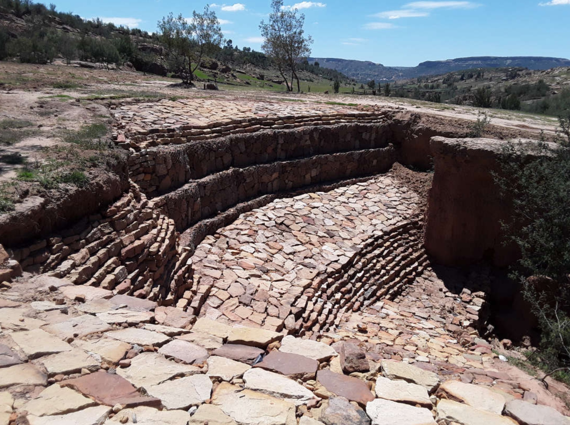
The aim of the gully head structure is to help stabilise the gully and prevent/control the gully from expanding further in length due to erosion. In Lesotho, this is constructed using stones.
2.2 Detailed description of the Technology
Description:
1. This technology is applied where gully erosion is prevalent in different land uses.
2. The technology is performed using stones where the gully is not very deep. However, where the depth of a gully is more than 2m in length, gabions or sand bags can be used to stabilise the gully and discourage further erosion.
3. The aim of the technology is control soil from eroding.
4. In most cases, this technology is implemented by use of stones available from the local area. But, measuring tape, spade, pick-axe and grass seed/sodds are also part of the inputs.
5. It controls soil erosion as it discourages the gully from expanding deeper and wider, therefore, soil loss is halted.
6. To land users, the technology is useful because it protects their fields as much gully erosion occurrs in cropland. At the same time, they regard as the most tedious technology due to use of stones.
2.3 Photos of the Technology
Media Gallery
General remarks regarding photos:
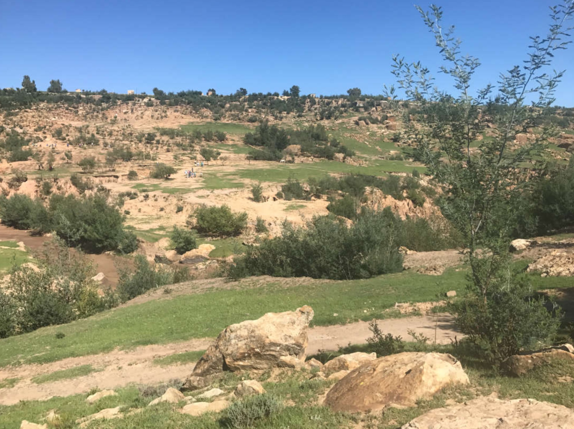
This technology is the most common in the country especially in the Southern parts of the country where desertification, land degradation and drought are more prevalent.
2.4 Videos of the Technology
Comments, short description:
N/A
الموقع:
N/A
Name of videographer:
N/A
2.5 Country/ region/ locations where the Technology has been applied and which are covered by this assessment
بلد:
Lesotho
Region/ State/ Province:
Leribe District
Further specification of location:
Peri-Urban
Specify the spread of the Technology:
- applied at specific points/ concentrated on a small area
Is/are the technology site(s) located in a permanently protected area?
لا
Comments:
The area where the technology is implemented is dry/ receives less rainfall. As the overview picture shows, there are very active and deep gulleys within the catchment area
Map
×2.6 Date of implementation
Indicate year of implementation:
2019
2.7 Introduction of the Technology
Specify how the Technology was introduced:
- as part of a traditional system (> 50 years)
- during experiments/ research
- through projects/ external interventions
Comments (type of project, etc.):
This technology has been practised for over the years in Lesotho in all catchment areas implemented by different projects.
3. Classification of the SLM Technology
3.1 Main purpose(s) of the Technology
- reduce, prevent, restore land degradation
3.2 Current land use type(s) where the Technology is applied
Land use mixed within the same land unit:
نعم
Specify mixed land use (crops/ grazing/ trees):
- Silvo-pastoralism

أراضي الرعي
Extensive grazing:
- Semi-nomadic pastoralism
- deferred grazing
Animal type:
- cattle - non-dairy working
Is integrated crop-livestock management practiced?
لا
Products and services:
- meat
- milk
- skins/ hides
Species:
cattle - non-dairy working
Count:
450

Settlements, infrastructure
- Settlements, buildings
Remarks:
peri-urban areas mostly developed with good roads, power lines and clean water.

Waterways, waterbodies, wetlands
- Drainage lines, waterways
Main products/ services:
The stream in this area is seasonal
Comments:
In this area, there is fine sand mining which does not benefit the community.
3.3 Has land use changed due to the implementation of the Technology?
Has land use changed due to the implementation of the Technology?
- No (Continue with question 3.4)
Comments:
There is encroachment of settlements into grazing areas
3.4 Water supply
Water supply for the land on which the Technology is applied:
- rainfed
Comments:
The community depends entirely on rain water for agricultural production, there is no irrigated water systems.
3.5 SLM group to which the Technology belongs
- erosion control measure
3.6 SLM measures comprising the Technology

structural measures
- S6: Walls, barriers, palisades, fences
Comments:
The technology comprises gully wall and check dam structures
3.7 Main types of land degradation addressed by the Technology

soil erosion by water
- Wg: gully erosion/ gullying
Comments:
The technology discourages land degradation by water through minimising length, width and depth of the gully
3.8 Prevention, reduction, or restoration of land degradation
Specify the goal of the Technology with regard to land degradation:
- reduce land degradation
Comments:
gully head structures are more useful and implemented in cropland and rangelands where gully erosion is more prevalent
4. Technical specifications, implementation activities, inputs, and costs
4.1 Technical drawing of the Technology
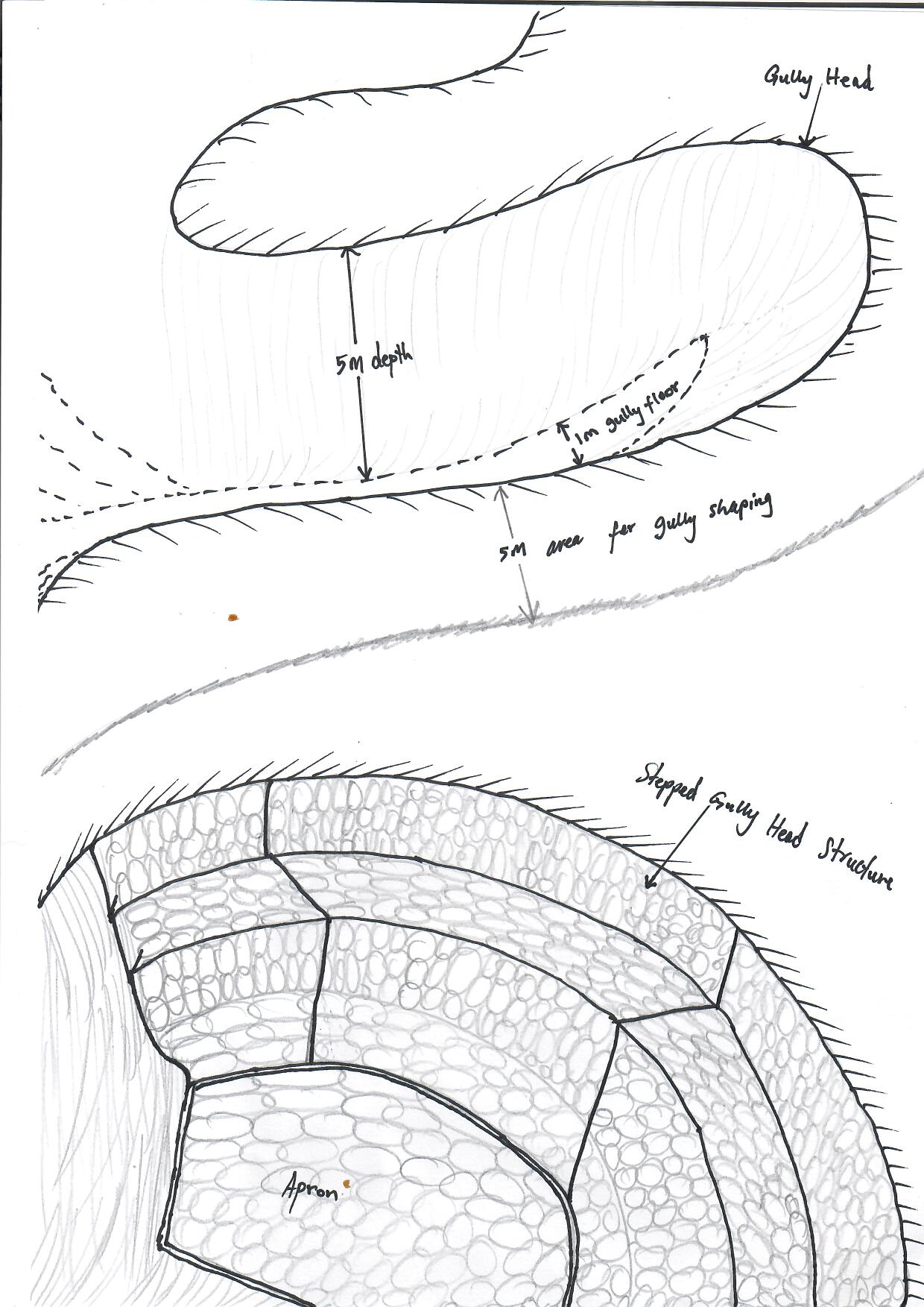
Technical specifications (related to technical drawing):
Technical Specifications
1. Dimensions; there are no specific dimensions as they are dependent on gully shape, depth, width and soil type.
2. Lateral gradient of the structure: gully shaping is pre-requisite before installation of the structure. Gully shaping is guided by the depth of the gully.
3. Construction material used: loose stones, gabions and gabion mattresses, sand bags, pick axe, measuring tape, spade
Author:
Koetlisi Koetlisi and Matoka Moshoeshoe
Date:
01/06/2012
4.2 General information regarding the calculation of inputs and costs
Specify how costs and inputs were calculated:
- per Technology area
Indicate size and area unit:
0.01ha
If using a local area unit, indicate conversion factor to one hectare (e.g. 1 ha = 2.47 acres): 1 ha =:
N/A
Specify currency used for cost calculations:
- USD
If relevant, indicate exchange rate from USD to local currency (e.g. 1 USD = 79.9 Brazilian Real): 1 USD =:
13,0
Indicate average wage cost of hired labour per day:
4.6
4.3 Establishment activities
| Activity | Timing (season) | |
|---|---|---|
| 1. | Public gathering | before onset of rains |
| 2. | survey | before onset of rains |
| 3. | design | before onset of rains |
| 4. | stone collection | before onset of rains |
| 5. | implementation | before onset of rains |
| 6. | monitoring and evaluation | after storm |
| 7. | maintenance | after storm |
Comments:
The technology is easy to implement except in areas where availability of loose rocks is a challenge. Also, where soils are problematic (duplex)
4.4 Costs and inputs needed for establishment
| Specify input | Unit | Quantity | Costs per Unit | Total costs per input | % of costs borne by land users | |
|---|---|---|---|---|---|---|
| Labour | one person | person days | 1,0 | 5,0 | 5,0 | 5,0 |
| Equipment | Gabions | one piece | 10,0 | 54,0 | 540,0 | |
| Equipment | Sand bags | one piece | 50,0 | 4,0 | 200,0 | |
| Equipment | Pick axe | one piece | 5,0 | 15,0 | 75,0 | |
| Equipment | spade | one piece | 5,0 | 12,0 | 60,0 | |
| Plant material | measuring tape | one piece | 1,0 | 6,0 | 6,0 | |
| Construction material | loose rocks | cubic | 10,0 | 15,0 | 150,0 | |
| Total costs for establishment of the Technology | 1036,0 | |||||
| Total costs for establishment of the Technology in USD | 79,69 | |||||
If land user bore less than 100% of costs, indicate who covered the remaining costs:
Government
Comments:
Normally implemented during integrated catchment management
4.5 Maintenance/ recurrent activities
| Activity | Timing/ frequency | |
|---|---|---|
| 1. | public gathering | After storm |
| 2. | participatory community monitoring and evaluation | After storm |
| 3. | Maintenance | After storm |
Comments:
Maintenance is always recommended after every storm
4.6 Costs and inputs needed for maintenance/ recurrent activities (per year)
| Specify input | Unit | Quantity | Costs per Unit | Total costs per input | % of costs borne by land users | |
|---|---|---|---|---|---|---|
| Labour | person | person days | 1,0 | 5,0 | 5,0 | 5,0 |
| Total costs for maintenance of the Technology | 5,0 | |||||
| Total costs for maintenance of the Technology in USD | 0,38 | |||||
If land user bore less than 100% of costs, indicate who covered the remaining costs:
Government
Comments:
gully head structures are some of the major which are implemented in catchment management throughout the country through integrated catchment management project.
4.7 Most important factors affecting the costs
Describe the most determinate factors affecting the costs:
National budget
5. Natural and human environment
5.1 Climate
Annual rainfall
- < 250 mm
- 251-500 mm
- 501-750 mm
- 751-1,000 mm
- 1,001-1,500 mm
- 1,501-2,000 mm
- 2,001-3,000 mm
- 3,001-4,000 mm
- > 4,000 mm
Specify average annual rainfall (if known), in mm:
800,00
Specifications/ comments on rainfall:
Generally, northern districts receive good amounts of rainfall, that is why agricultural productivity is very good.
Indicate the name of the reference meteorological station considered:
Hlotse
Agro-climatic zone
- semi-arid
the area is generally cool with intermittent rains in winter and warm and moist in summer
5.2 Topography
Slopes on average:
- flat (0-2%)
- gentle (3-5%)
- moderate (6-10%)
- rolling (11-15%)
- hilly (16-30%)
- steep (31-60%)
- very steep (>60%)
Landforms:
- plateau/plains
- ridges
- mountain slopes
- hill slopes
- footslopes
- valley floors
Altitudinal zone:
- 0-100 m a.s.l.
- 101-500 m a.s.l.
- 501-1,000 m a.s.l.
- 1,001-1,500 m a.s.l.
- 1,501-2,000 m a.s.l.
- 2,001-2,500 m a.s.l.
- 2,501-3,000 m a.s.l.
- 3,001-4,000 m a.s.l.
- > 4,000 m a.s.l.
Indicate if the Technology is specifically applied in:
- concave situations
Comments and further specifications on topography:
The activity is implemented on gentle to moderate slopes
5.3 Soils
Soil depth on average:
- very shallow (0-20 cm)
- shallow (21-50 cm)
- moderately deep (51-80 cm)
- deep (81-120 cm)
- very deep (> 120 cm)
Soil texture (topsoil):
- medium (loamy, silty)
Soil texture (> 20 cm below surface):
- medium (loamy, silty)
Topsoil organic matter:
- low (<1%)
If available, attach full soil description or specify the available information, e.g. soil type, soil PH/ acidity, Cation Exchange Capacity, nitrogen, salinity etc.
A detailed soil map of Lesotho could be accessed at https://lesis.gov.ls
5.4 Water availability and quality
Ground water table:
5-50 m
Availability of surface water:
medium
Water quality (untreated):
good drinking water
Water quality refers to:
both ground and surface water
Is water salinity a problem?
لا
Is flooding of the area occurring?
لا
Comments and further specifications on water quality and quantity:
Most of water in this area is harvested from springs
5.5 Biodiversity
Species diversity:
- low
Habitat diversity:
- low
Comments and further specifications on biodiversity:
The area is severely eroded and therefore has minimum biodiversity attributed to escalation of bare lands
5.6 Characteristics of land users applying the Technology
Sedentary or nomadic:
- Semi-nomadic
Market orientation of production system:
- mixed (subsistence/ commercial)
Off-farm income:
- 10-50% of all income
Relative level of wealth:
- average
Individuals or groups:
- individual/ household
- groups/ community
Level of mechanization:
- manual work
- animal traction
Gender:
- women
- men
Age of land users:
- middle-aged
- elderly
Indicate other relevant characteristics of the land users:
The middle aged and elderly are the ones interested in land management activities relative to their experiences with long term involvement in land management
5.7 Average area of land used by land users applying the Technology
- < 0.5 ha
- 0.5-1 ha
- 1-2 ha
- 2-5 ha
- 5-15 ha
- 15-50 ha
- 50-100 ha
- 100-500 ha
- 500-1,000 ha
- 1,000-10,000 ha
- > 10,000 ha
Is this considered small-, medium- or large-scale (referring to local context)?
- small-scale
Comments:
The area has a challenge of unavailability of loose rocks
5.8 Land ownership, land use rights, and water use rights
Land ownership:
- communal/ village
- individual, titled
Land use rights:
- open access (unorganized)
- communal (organized)
Water use rights:
- open access (unorganized)
- communal (organized)
Are land use rights based on a traditional legal system?
نعم
حددها:
This is due to Lesotho land tenure system
Comments:
In Lesotho, land is communally owned. However, this might change due to implementation of decentralisation process as well as population increase
5.9 Access to services and infrastructure
health:
- poor
- moderate
- good
education:
- poor
- moderate
- good
technical assistance:
- poor
- moderate
- good
employment (e.g. off-farm):
- poor
- moderate
- good
markets:
- poor
- moderate
- good
energy:
- poor
- moderate
- good
roads and transport:
- poor
- moderate
- good
drinking water and sanitation:
- poor
- moderate
- good
financial services:
- poor
- moderate
- good
Comments:
The community lives closer to town therefore, enjoys much of services from the government services and facilities.
6. Impacts and concluding statements
6.1 On-site impacts the Technology has shown
Socio-economic impacts
Production
land management
Quantity before SLM:
increase in soil erosion
Quantity after SLM:
soil erosion minimised
Comments/ specify:
utilisation of protected and marginal land improved
Ecological impacts
Soil
soil loss
Quantity before SLM:
much soil loss
Quantity after SLM:
controlled erosion
Comments/ specify:
sediment load reduced from the nearby water bodies
Specify assessment of on-site impacts (measurements):
Soil erosion, properties and quality assessed
6.2 Off-site impacts the Technology has shown
downstream siltation
Quantity before SLM:
more silt in downstream water bodies
Quantity after SLM:
minimised silt downstream
Comments/ specify:
water pollution by particulate clastic material is minimised as structures are constructed
Specify assessment of off-site impacts (measurements):
Soil erosion, properties and quality assessed off-site to aid in the management of adjacent land
6.3 Exposure and sensitivity of the Technology to gradual climate change and climate-related extremes/ disasters (as perceived by land users)
Gradual climate change
Gradual climate change
| Season | increase or decrease | How does the Technology cope with it? | |
|---|---|---|---|
| annual temperature | increase | not well | |
| annual rainfall | increase | not well at all |
Climate-related extremes (disasters)
Meteorological disasters
| How does the Technology cope with it? | |
|---|---|
| local hailstorm | not well |
Climatological disasters
| How does the Technology cope with it? | |
|---|---|
| drought | moderately |
Hydrological disasters
| How does the Technology cope with it? | |
|---|---|
| landslide | not well at all |
Comments:
The duplex soils found in this area prohibit use of heavy structures
6.4 Cost-benefit analysis
How do the benefits compare with the establishment costs (from land users’ perspective)?
Short-term returns:
neutral/ balanced
Long-term returns:
slightly positive
How do the benefits compare with the maintenance/ recurrent costs (from land users' perspective)?
Short-term returns:
neutral/ balanced
Long-term returns:
slightly positive
Comments:
The land users who own land found the technology very useful as much gully erosion occurs in crop land
6.5 Adoption of the Technology
- 11-50%
If available, quantify (no. of households and/ or area covered):
20
Of all those who have adopted the Technology, how many did so spontaneously, i.e. without receiving any material incentives/ payments?
- 0-10%
Comments:
Land owners found it important to adopt the technology as against those community members who only have land user rights.
6.6 التكيف
Has the Technology been modified recently to adapt to changing conditions?
نعم
If yes, indicate to which changing conditions it was adapted:
- climatic change/ extremes
Specify adaptation of the Technology (design, material/ species, etc.):
The design is affected mainly by rainfall intensity and frequency which are influenced by changes in climate
6.7 Strengths/ advantages/ opportunities of the Technology
| Strengths/ advantages/ opportunities in the land user’s view |
|---|
| It uses locally available material |
| It is easy to implement |
| Protects productive soil in major land uses |
| Strengths/ advantages/ opportunities in the compiler’s or other key resource person’s view |
|---|
| provides support to other structural strength against further damage |
| Reduces the force of run-off |
| Prevents soil loss in productive land |
6.8 Weaknesses/ disadvantages/ risks of the Technology and ways of overcoming them
| Weaknesses/ disadvantages/ risks in the land user’s view | How can they be overcome? |
|---|---|
| Labour intensive | use of machinery is recommended |
| It requires basic skill to implement | on-site demonstrations |
| If the locally available material is not enough to complete the construction work, then the structure cannot be implemented. | other alternative locally available materials should be advocated for |
| Weaknesses/ disadvantages/ risks in the compiler’s or other key resource person’s view | How can they be overcome? |
|---|---|
| Structures need to be matched to sites where they are corrected | If a heavy structure will not be sustainable, suitable light structures should be recommended |
| If the design is not properly made, it may cause more harm than good on land | Design must always succinct |
| It needs maintenance periodically | This one is a must do activity |
7. References and links
7.1 Methods/ sources of information
- field visits, field surveys
45
When were the data compiled (in the field)?
18/02/2019
Comments:
Information accessed through community participation in natural resource management and land use planning
7.2 References to available publications
Title, author, year, ISBN:
N/A
Available from where? Costs?
N/A
7.3 Links to relevant online information
Title/ description:
Department of Soil and Water Conservation
URL:
https://forestry.gov.ls
7.4 General comments
In the beginning it was not easy to fill the questionnaire, however, as time went on the team began to enjoy the questionnaire
Links and modules
Expand all Collapse allLinks
Social Infrastructure for Soil Conservation [Ethiopia]
Negotiation with the stakeholder community of a catchment on social incentives to be offered by external agency in exchange of additional inputs by the communty to be invested into soil and water conservation measures.
- Compiler: Hans Hurni
Modules
No modules