Gully head structure [เลโซโท]
- ผู้สร้างสรรค์:
- การอัพเดท:
- ผู้รวบรวม: Matoka Moshoeshoe
- ผู้เรียบเรียง: –
- ผู้ตรวจสอบ: Rima Mekdaschi Studer, William Critchley
Gully head
technologies_4595 - เลโซโท
ดูส่วนย่อย
ขยายทั้งหมด ย่อทั้งหมด1. ข้อมูลทั่วไป
1.2 รายละเอียดที่ติดต่อได้ของผู้รวบรวมและองค์กรที่เกี่ยวข้องในการประเมินและการจัดเตรียมทำเอกสารของเทคโนโลยี
ชื่อของโครงการซึ่งอำนวยความสะดวกในการทำเอกสารหรือการประเมินเทคโนโลยี (ถ้าเกี่ยวข้อง)
Decision Support for Mainstreaming and Scaling out Sustainable Land Management (GEF-FAO / DS-SLM)ชื่อขององค์กรซึ่งอำนวยความสะดวกในการทำเอกสารหรือการประเมินเทคโนโลยี (ถ้าเกี่ยวข้อง)
Integrated Catchment Management Project (Integrated Catchment Management Project) - เลโซโท1.3 เงื่อนไขการใช้ข้อมูลที่ได้บันทึกผ่านทาง WOCAT
ผู้รวบรวมและวิทยากรหลักยอมรับเงื่อนไขเกี่ยวกับการใช้ข้อมูลที่ถูกบันทึกผ่านทาง WOCAT:
ใช่
1.4 การเปิดเผยเรื่องความยั่งยืนของเทคโนโลยีที่ได้อธิบายไว้
เทคโนโลยีที่ได้อธิบายไว้นี้เป็นปัญหาของความเสื่อมโทรมโทรมของที่ดินหรือไม่ จึงไม่ได้รับการยอมรับว่าเป็นเทคโนโลยีเพื่อการจัดการที่ดินอย่างยั่งยืน:
ไม่ใช่
แสดงความคิดเห็น:
This technology helps to stabilise the gully and prevents the gully from expanding further in length due to erosion.
1.5 Reference to Questionnaire(s) on SLM Approaches (documented using WOCAT)

Social Infrastructure for Soil Conservation [เอธิโอเปีย]
Negotiation with the stakeholder community of a catchment on social incentives to be offered by external agency in exchange of additional inputs by the communty to be invested into soil and water conservation measures.
- ผู้รวบรวม: Hans Hurni
2. การอธิบายลักษณะของเทคโนโลยี SLM
2.1 การอธิบายแบบสั้น ๆ ของเทคโนโลยี
คำจำกัดความของเทคโนโลยี:
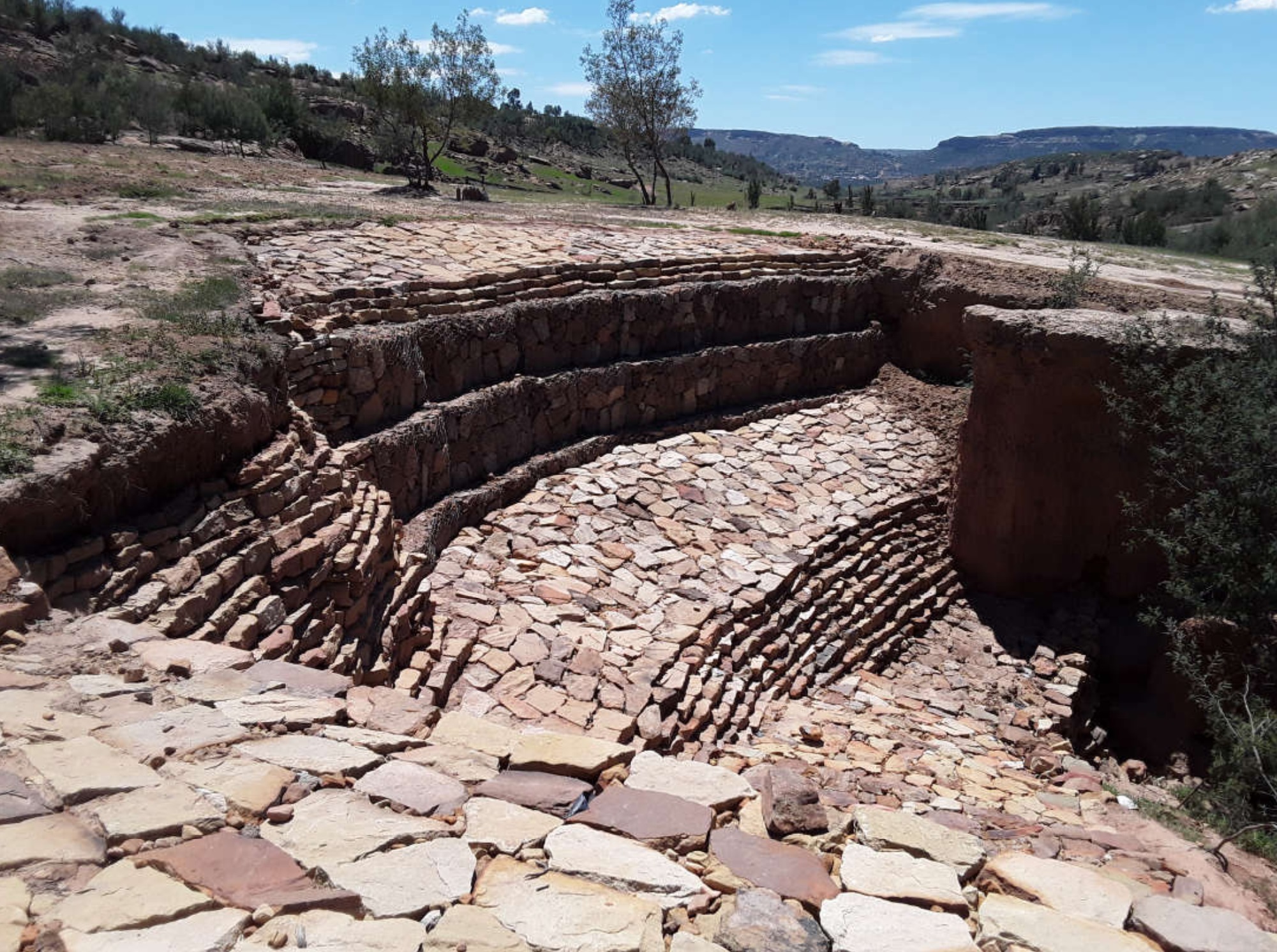
The aim of the gully head structure is to help stabilise the gully and prevent/control the gully from expanding further in length due to erosion. In Lesotho, this is constructed using stones.
2.2 การอธิบายแบบละเอียดของเทคโนโลยี
คำอธิบาย:
1. This technology is applied where gully erosion is prevalent in different land uses.
2. The technology is performed using stones where the gully is not very deep. However, where the depth of a gully is more than 2m in length, gabions or sand bags can be used to stabilise the gully and discourage further erosion.
3. The aim of the technology is control soil from eroding.
4. In most cases, this technology is implemented by use of stones available from the local area. But, measuring tape, spade, pick-axe and grass seed/sodds are also part of the inputs.
5. It controls soil erosion as it discourages the gully from expanding deeper and wider, therefore, soil loss is halted.
6. To land users, the technology is useful because it protects their fields as much gully erosion occurrs in cropland. At the same time, they regard as the most tedious technology due to use of stones.
2.3 รูปภาพของเทคโนโลยี
อัลบั้มสื่อบันทึก
คำอธิบายภาพ:
This technology is the most common in the country especially in the Southern parts of the country where desertification, land degradation and drought are more prevalent.
2.4 วีดีโอของเทคโนโลยี
ความคิดเห็น/อธิบายสั้นๆ:
N/A
สถานที่:
N/A
ชื่อผู้ถ่ายวีดีโอ:
N/A
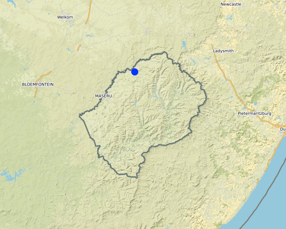
2.5 ประเทศภูมิภาค หรือสถานที่ตั้งที่เทคโนโลยีได้นำไปใช้และได้รับการครอบคลุมโดยการประเมินนี้
ประเทศ:
เลโซโท
ภูมิภาค/รัฐ/จังหวัด:
Leribe District
ข้อมูลจำเพาะเพิ่มเติมของสถานที่ตั้ง :
Peri-Urban
ระบุการกระจายตัวของเทคโนโลยี:
- ใช้ ณ จุดที่เฉพาะเจาะจงหรือเน้นไปยังบริเวณพื้นที่ขนาดเล็ก
Is/are the technology site(s) located in a permanently protected area?
ไม่ใช่
แสดงความคิดเห็น:
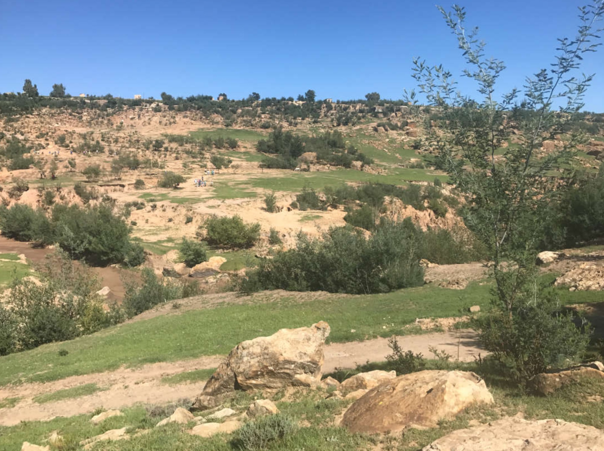
The area where the technology is implemented is dry/ receives less rainfall. As the overview picture shows, there are very active and deep gulleys within the catchment area
Map
×2.6 วันที่การดำเนินการ
ระบุปีที่ใช้:
2019
2.7 คำแนะนำของเทคโนโลยี
ให้ระบุว่าเทคโนโลยีถูกแนะนำเข้ามาอย่างไร:
- เป็นส่วนหนึ่งของระบบแบบดั้งเดิมที่ทำก้นอยู่ (> 50 ปี)
- ในช่วงการทดลองหรือการทำวิจัย
- ทางโครงการหรือจากภายนอก
ความคิดเห็น (ประเภทของโครงการ เป็นต้น) :
This technology has been practised for over the years in Lesotho in all catchment areas implemented by different projects.
3. การจัดประเภทของเทคโนโลยี SLM
3.1 วัตถุประสงค์หลักของเทคโนโลยี
- ลด ป้องกัน ฟื้นฟู การเสื่อมโทรมของที่ดิน
3.2 ประเภทของการใช้ที่ดินในปัจจุบันที่ได้นำเทคโนโลยีไปใช้
Land use mixed within the same land unit:
ใช่
Specify mixed land use (crops/ grazing/ trees):
- ปศุสัตว์ร่วมกับการทำป่าไม้ (Silvo-pastoralism)

ทุ่งหญ้าเลี้ยงสัตว์
Extensive grazing:
- กึ่งโนแมนดิซึ่มหรือแพสโตแรลลิซึ่ม (Semi-nomadism/pastoralism)
- deferred grazing
Animal type:
- cattle - non-dairy working
Is integrated crop-livestock management practiced?
ไม่ใช่
ผลิตภัณฑ์และบริการ:
- meat
- milk
- skins/ hides
Species:
cattle - non-dairy working
Count:
450

การตั้งถิ่นฐาน โครงสร้างพื้นฐาน
- การตั้งถิ่นฐาน ตึกอาคาร
ข้อสังเกต:
peri-urban areas mostly developed with good roads, power lines and clean water.

ทางน้ำ แหล่งน้ำ พื้นที่ชุ่มน้ำ
- ทางระบายน้ำ ทางน้ำ
ผลิตภัณฑ์หลักหรือบริการ:
The stream in this area is seasonal
แสดงความคิดเห็น:
In this area, there is fine sand mining which does not benefit the community.
3.3 Has land use changed due to the implementation of the Technology?
Has land use changed due to the implementation of the Technology?
- No (Continue with question 3.4)
แสดงความคิดเห็น:
There is encroachment of settlements into grazing areas
3.4 การใช้น้ำ
การใช้น้ำของที่ดินที่มีการใช้เทคโนโลยีอยู่:
- จากน้ำฝน
แสดงความคิดเห็น:
The community depends entirely on rain water for agricultural production, there is no irrigated water systems.
3.5 กลุ่ม SLM ที่ตรงกับเทคโนโลยีนี้
- erosion control measure
3.6 มาตรการ SLM ที่ประกอบกันเป็นเทคโนโลยี

มาตรการอนุรักษ์ด้วยโครงสร้าง
- S6: กำแพง สิ่งกีดขวาง รั้วไม้ รั้วต่างๆ
แสดงความคิดเห็น:
The technology comprises gully wall and check dam structures
3.7 รูปแบบหลักของการเสื่อมโทรมของที่ดินที่ได้รับการแก้ไขโดยเทคโนโลยี

การกัดกร่อนของดินโดยน้ำ
- Wg (Gully erosion): การกัดกร่อนแบบร่องธารหรือการทำให้เกิดร่องน้ำเซาะ
แสดงความคิดเห็น:
The technology discourages land degradation by water through minimising length, width and depth of the gully
3.8 การป้องกัน การลดลง หรือการฟื้นฟูความเสื่อมโทรมของที่ดิน
ระบุเป้าหมายของเทคโนโลยีกับความเสื่อมโทรมของที่ดิน:
- ลดความเสื่อมโทรมของดิน
แสดงความคิดเห็น:
gully head structures are more useful and implemented in cropland and rangelands where gully erosion is more prevalent
4. ข้อมูลจำเพาะด้านเทคนิค กิจกรรมการนำไปปฏิบัติใช้ ปัจจัยนำเข้า และค่าใช้จ่าย
4.1 แบบแปลนทางเทคนิคของเทคโนโลยี
ข้อมูลจำเพาะด้านเทคนิค (แบบแปลนทางเทคนิคของเทคโนโลยี):
Technical Specifications
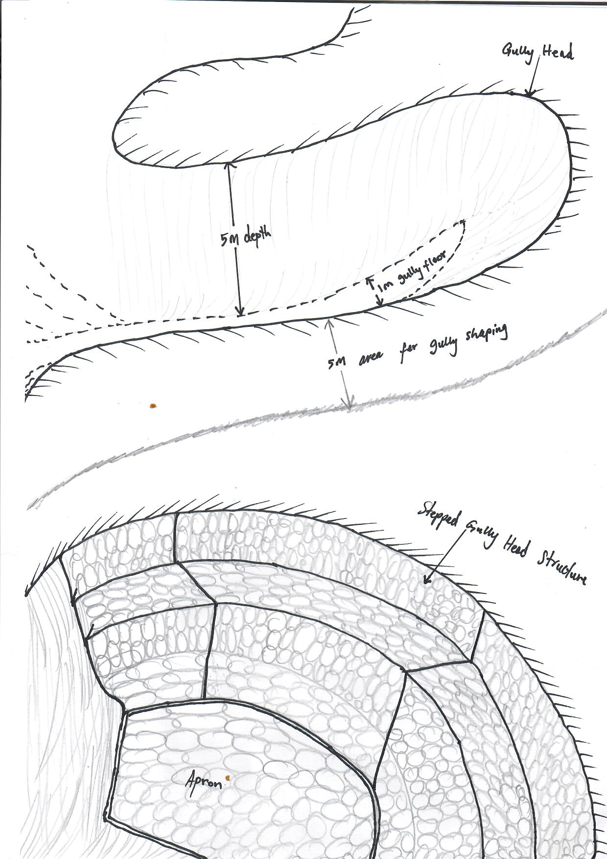
1. Dimensions; there are no specific dimensions as they are dependent on gully shape, depth, width and soil type.
2. Lateral gradient of the structure: gully shaping is pre-requisite before installation of the structure. Gully shaping is guided by the depth of the gully.
3. Construction material used: loose stones, gabions and gabion mattresses, sand bags, pick axe, measuring tape, spade
ผู้เขียน:
Koetlisi Koetlisi and Matoka Moshoeshoe
วันที่:
01/06/2012
4.2 ข้อมูลทั่วไปเกี่ยวกับการคำนวณปัจจัยนำเข้าและค่าใช้จ่าย
ให้ระบุว่าค่าใช้จ่ายและปัจจัยนำเข้าได้รับการคำนวณอย่างไร:
- ต่อพื้นที่ที่ใช้เทคโนโลยี
ระบุขนาดและหน่วยพื้นที่:
0.01ha
If using a local area unit, indicate conversion factor to one hectare (e.g. 1 ha = 2.47 acres): 1 ha =:
N/A
ระบุสกุลเงินที่ใช้คำนวณค่าใช้จ่าย:
- USD
If relevant, indicate exchange rate from USD to local currency (e.g. 1 USD = 79.9 Brazilian Real): 1 USD =:
13.0
ระบุค่าเฉลี่ยของค่าจ้างในการจ้างแรงงานต่อวัน:
4.6
4.3 กิจกรรมเพื่อการจัดตั้ง
| กิจกรรม | Timing (season) | |
|---|---|---|
| 1. | Public gathering | before onset of rains |
| 2. | survey | before onset of rains |
| 3. | design | before onset of rains |
| 4. | stone collection | before onset of rains |
| 5. | implementation | before onset of rains |
| 6. | monitoring and evaluation | after storm |
| 7. | maintenance | after storm |
แสดงความคิดเห็น:
The technology is easy to implement except in areas where availability of loose rocks is a challenge. Also, where soils are problematic (duplex)
4.4 ค่าใช้จ่ายของปัจจัยนำเข้าที่จำเป็นสำหรับการจัดตั้ง
| ปัจจัยนำเข้า | หน่วย | ปริมาณ | ค่าใช้จ่ายต่อหน่วย | ค่าใช้จ่ายทั้งหมดต่อปัจจัยนำเข้า | %ของค่าใช้จ่ายที่ก่อให้เกิดขึ้นโดยผู้ใช้ที่ดิน | |
|---|---|---|---|---|---|---|
| แรงงาน | one person | person days | 1.0 | 5.0 | 5.0 | 5.0 |
| อุปกรณ์ | Gabions | one piece | 10.0 | 54.0 | 540.0 | |
| อุปกรณ์ | Sand bags | one piece | 50.0 | 4.0 | 200.0 | |
| อุปกรณ์ | Pick axe | one piece | 5.0 | 15.0 | 75.0 | |
| อุปกรณ์ | spade | one piece | 5.0 | 12.0 | 60.0 | |
| วัสดุด้านพืช | measuring tape | one piece | 1.0 | 6.0 | 6.0 | |
| วัสดุสำหรับก่อสร้าง | loose rocks | cubic | 10.0 | 15.0 | 150.0 | |
| ค่าใช้จ่ายทั้งหมดของการจัดตั้งเทคโนโลยี | 1036.0 | |||||
| Total costs for establishment of the Technology in USD | 79.69 | |||||
ถ้าผู้ใช้ที่ดินรับภาระน้อยกว่า 100% ของค่าใช้จ่าย ให้ระบุว่าใครเป็นผู้รับผิดชอบส่วนที่เหลือ:
Government
แสดงความคิดเห็น:
Normally implemented during integrated catchment management
4.5 การบำรุงรักษาสภาพหรือกิจกรรมที่เกิดขึ้นเป็นประจำ
| กิจกรรม | ช่วงระยะเวลา/ความถี่ | |
|---|---|---|
| 1. | public gathering | After storm |
| 2. | participatory community monitoring and evaluation | After storm |
| 3. | Maintenance | After storm |
แสดงความคิดเห็น:
Maintenance is always recommended after every storm
4.6 ค่าใช้จ่ายของปัจจัยนำเข้าและกิจกรรมที่เกิดขึ้นเป็นประจำที่ต้องการการบำรุงรักษา (ต่อปี)
| ปัจจัยนำเข้า | หน่วย | ปริมาณ | ค่าใช้จ่ายต่อหน่วย | ค่าใช้จ่ายทั้งหมดต่อปัจจัยนำเข้า | %ของค่าใช้จ่ายที่ก่อให้เกิดขึ้นโดยผู้ใช้ที่ดิน | |
|---|---|---|---|---|---|---|
| แรงงาน | person | person days | 1.0 | 5.0 | 5.0 | 5.0 |
| ค่าใช้จ่ายทั้งหมดของการบำรุงรักษาสภาพเทคโนโลยี | 5.0 | |||||
| Total costs for maintenance of the Technology in USD | 0.38 | |||||
ถ้าผู้ใช้ที่ดินรับภาระน้อยกว่า 100% ของค่าใช้จ่าย ให้ระบุว่าใครเป็นผู้รับผิดชอบส่วนที่เหลือ:
Government
แสดงความคิดเห็น:
gully head structures are some of the major which are implemented in catchment management throughout the country through integrated catchment management project.
4.7 ปัจจัยสำคัญที่สุดที่มีผลกระทบต่อค่าใช้จ่าย
ปัจจัยสำคัญที่สุดที่มีผลกระทบต่อค่าใช้จ่ายต่างๆ:
National budget
5. สิ่งแวดล้อมทางธรรมชาติและของมนุษย์
5.1 ภูมิอากาศ
ฝนประจำปี
- < 250 ม.ม.
- 251-500 ม.ม.
- 501-750 ม.ม.
- 751-1,000 ม.ม.
- 1,001-1,500 ม.ม.
- 1,501-2,000 ม.ม.
- 2,001-3,000 ม.ม.
- 3,001-4,000 ม.ม.
- > 4,000 ม.ม.
ระบุปริมาณน้ำฝนเฉลี่ยรายปี (ถ้ารู้) :หน่วย ม.ม.
800.00
ข้อมูลจำเพาะ/ความคิดเห็นเรื่องปริมาณน้ำฝน:
Generally, northern districts receive good amounts of rainfall, that is why agricultural productivity is very good.
ระบุชื่อของสถานีตรวดวัดอากาศที่ใช้อ้างอิงคือ:
Hlotse
เขตภูมิอากาศเกษตร
- กึ่งแห้งแล้ง
the area is generally cool with intermittent rains in winter and warm and moist in summer
5.2 สภาพภูมิประเทศ
ค่าเฉลี่ยความลาดชัน:
- ราบเรียบ (0-2%)
- ลาดที่ไม่ชัน (3-5%)
- ปานกลาง (6-10%)
- เป็นลูกคลื่น (11-15%)
- เป็นเนิน (16-30%)
- ชัน (31-60%)
- ชันมาก (>60%)
ธรณีสัณฐาน:
- ที่ราบสูง/ที่ราบ
- สันเขา
- ไหล่เขา
- ไหล่เนินเขา
- ตีนเนิน
- หุบเขา
ระดับความสูง:
- 0-100 เมตร
- 101-500 เมตร
- 501-1,000 เมตร
- 1,001-1,500 เมตร
- 1,501-2,000 เมตร
- 2,001-2,500 เมตร
- 2,501-3,000 เมตร
- 3,001-4,000 เมตร
- > 4,000 เมตร
ให้ระบุถ้าเทคโนโลยีได้ถูกนำไปใช้:
- บริเวณแอ่งบนที่ราบ (concave situations)
ความคิดเห็นและข้อมูลจำเพาะเพิ่มเติมเรื่องสภาพภูมิประเทศ:
The activity is implemented on gentle to moderate slopes
5.3 ดิน
ค่าเฉลี่ยความลึกของดิน:
- ตื้นมาก (0-20 ซ.ม.)
- ตื้น (21-50 ซ.ม.)
- ลึกปานกลาง (51-80 ซ.ม.)
- ลึก (81-120 ซ.ม.)
- ลึกมาก (>120 ซ.ม.)
เนื้อดิน (ดินชั้นบน):
- ปานกลาง (ดินร่วน ทรายแป้ง)
เนื้อดินล่าง (> 20 ซ.ม.ต่ำจากผิวดิน):
- ปานกลาง (ดินร่วน ทรายแป้ง)
อินทรียวัตถุในดิน:
- ต่ำ (<1%)
(ถ้ามี) ให้แนบคำอธิบายเรื่องดินแบบเต็มหรือระบุข้อมูลที่มีอยู่ เช่น ชนิดของดิน ค่า pH ของดินหรือความเป็นกรดของดิน ความสามารถในการแลกเปลี่ยนประจุบวก ไนโตรเจน ความเค็ม เป็นต้น:
A detailed soil map of Lesotho could be accessed at https://lesis.gov.ls
5.4 ความเป็นประโยชน์และคุณภาพของน้ำ
ระดับน้ำใต้ดิน:
5-50 เมตร
น้ำไหลบ่าที่ผิวดิน:
ปานกลาง
คุณภาพน้ำ (ที่ยังไม่ได้บำบัด):
เป็นน้ำเพื่อการดื่มที่ดี
Water quality refers to:
both ground and surface water
ความเค็มของน้ำเป็นปัญหาหรือไม่:
ไม่ใช่
กำลังเกิดน้ำท่วมในพื้นที่หรือไม่:
ไม่ใช่
ความคิดเห็นและข้อมูลจำเพาะเพิ่มเติมเรื่องคุณภาพและปริมาณน้ำ:
Most of water in this area is harvested from springs
5.5 ความหลากหลายทางชีวภาพ
ความหลากหลายทางชนิดพันธุ์:
- ต่ำ
ความหลากหลายของแหล่งที่อยู่:
- ต่ำ
ความคิดเห็นและข้อมูลจำเพาะเพิ่มเติมของความหลากหลายทางชีวภาพ:
The area is severely eroded and therefore has minimum biodiversity attributed to escalation of bare lands
5.6 ลักษณะของผู้ใช้ที่ดินที่นำเทคโนโลยีไปปฏิบัติใช้
อยู่กับที่หรือเร่ร่อน:
- กึ่งเร่ร่อน
แนวทางการตลาดของระบบการผลิต:
- mixed (subsistence/ commercial)
รายได้ที่มาจากนอกฟาร์ม:
- 10-50% ของรายได้ทั้งหมด
ระดับของความมั่งคั่งโดยเปรียบเทียบ:
- พอมีพอกิน
เป็นรายบุคคล/ครัวเรือน:
- เป็นรายบุคคล/ครัวเรือน
- กลุ่ม/ชุมชน
ระดับของการใช้เครื่องจักรกล:
- งานที่ใช้แรงกาย
- การใช้กำลังจากสัตว์
เพศ:
- หญิง
- ชาย
อายุของผู้ใช้ที่ดิน:
- วัยกลางคน
- ผู้สูงอายุ
ระบุลักษณะอื่นๆที่เกี่ยวข้องของผู้ใช้ที่ดิน:
The middle aged and elderly are the ones interested in land management activities relative to their experiences with long term involvement in land management
5.7 Average area of land used by land users applying the Technology
- < 0.5 เฮกตาร์
- 0.5-1 เฮกตาร์
- 1-2 เฮกตาร์
- 2-5 เฮกตาร์
- 5-15 เฮกตาร์
- 15-50 เฮกตาร์
- 50-100 เฮกตาร์
- 100-500 เฮกตาร์
- 500-1,000 เฮกตาร์
- 1,000-10,000 เฮกตาร์
- >10,000 เฮกตาร์
พิจารณาว่าเป็นขนาดเล็ก กลาง หรือขนาดใหญ่ (ซึ่งอ้างอิงถึงบริบทระดับท้องถิ่น):
- ขนาดเล็ก
แสดงความคิดเห็น:
The area has a challenge of unavailability of loose rocks
5.8 กรรมสิทธิ์ในที่ดิน สิทธิในการใช้ที่ดินและสิทธิในการใช้น้ำ
กรรมสิทธิ์ในที่ดิน:
- เป็นแบบชุมชนหรือหมู่บ้าน
- รายบุคคล ได้รับสิทธิครอบครอง
สิทธิในการใช้ที่ดิน:
- เข้าถึงได้แบบเปิด (ไม่ได้จัดระเบียบ)
- เกี่ยวกับชุมชน (ถูกจัดระเบียบ)
สิทธิในการใช้น้ำ:
- เข้าถึงได้แบบเปิด (ไม่ได้จัดระเบียบ)
- เกี่ยวกับชุมชน (ถูกจัดระเบียบ)
Are land use rights based on a traditional legal system?
ใช่
ระบุ:
This is due to Lesotho land tenure system
แสดงความคิดเห็น:
In Lesotho, land is communally owned. However, this might change due to implementation of decentralisation process as well as population increase
5.9 การเข้าถึงบริการและโครงสร้างพื้นฐาน
สุขภาพ:
- จน
- ปานกลาง
- ดี
การศึกษา:
- จน
- ปานกลาง
- ดี
ความช่วยเหลือทางด้านเทคนิค:
- จน
- ปานกลาง
- ดี
การจ้างงาน (เช่น ภายนอกฟาร์ม):
- จน
- ปานกลาง
- ดี
ตลาด:
- จน
- ปานกลาง
- ดี
พลังงาน:
- จน
- ปานกลาง
- ดี
ถนนและการขนส่ง:
- จน
- ปานกลาง
- ดี
น้ำดื่มและการสุขาภิบาล:
- จน
- ปานกลาง
- ดี
บริการด้านการเงิน:
- จน
- ปานกลาง
- ดี
แสดงความคิดเห็น:
The community lives closer to town therefore, enjoys much of services from the government services and facilities.
6. ผลกระทบและสรุปคำบอกกล่าว
6.1 ผลกระทบในพื้นที่ดำเนินการ (On-site) จากการใช้เทคโนโลยี
ผลกระทบทางด้านเศรษฐกิจและสังคม
การผลิต
การจัดการที่ดิน
จำนวนก่อน SLM:
increase in soil erosion
หลังจาก SLM:
soil erosion minimised
แสดงความคิดเห็น/ระบุ:
utilisation of protected and marginal land improved
ผลกระทบด้านนิเวศวิทยา
ดิน
การสูญเสียดิน
จำนวนก่อน SLM:
much soil loss
หลังจาก SLM:
controlled erosion
แสดงความคิดเห็น/ระบุ:
sediment load reduced from the nearby water bodies
Specify assessment of on-site impacts (measurements):
Soil erosion, properties and quality assessed
6.2 ผลกระทบนอกพื้นที่ดำเนินการ (Off-site) จากการใช้เทคโนโลยี
การทับถมของดินตะกอนพื้นที่ท้ายน้ำ
จำนวนก่อน SLM:
more silt in downstream water bodies
หลังจาก SLM:
minimised silt downstream
แสดงความคิดเห็น/ระบุ:
water pollution by particulate clastic material is minimised as structures are constructed
Specify assessment of off-site impacts (measurements):
Soil erosion, properties and quality assessed off-site to aid in the management of adjacent land
6.3 การเผชิญและความตอบสนองของเทคโนโลยีต่อการเปลี่ยนแปลงสภาพภูมิอากาศที่ค่อยเป็นค่อยไป และสภาพรุนแรงของภูมิอากาศ / ภัยพิบัติ (ที่รับรู้ได้โดยผู้ใช้ที่ดิน)
การเปลี่ยนแปลงสภาพภูมิอากาศที่ค่อยเป็นค่อยไป
การเปลี่ยนแปลงสภาพภูมิอากาศที่ค่อยเป็นค่อยไป
| ฤดู | increase or decrease | เทคโนโลยีมีวิธีการรับมืออย่างไร | |
|---|---|---|---|
| อุณหภูมิประจำปี | เพิ่มขึ้น | ไม่ค่อยดี | |
| ฝนประจำปี | เพิ่มขึ้น | ไม่ดี |
สภาพรุนแรงของภูมิอากาศ (ภัยพิบัติ)
ภัยพิบัติทางอุตุนิยมวิทยา
| เทคโนโลยีมีวิธีการรับมืออย่างไร | |
|---|---|
| พายุลูกเห็บประจำท้องถิ่น | ไม่ค่อยดี |
ภัยพิบัติจากสภาพภูมิอากาศ
| เทคโนโลยีมีวิธีการรับมืออย่างไร | |
|---|---|
| ภัยจากฝนแล้ง | ปานกลาง |
ภัยพิบัติจากน้ำ
| เทคโนโลยีมีวิธีการรับมืออย่างไร | |
|---|---|
| ดินถล่ม | ไม่ดี |
แสดงความคิดเห็น:
The duplex soils found in this area prohibit use of heavy structures
6.4 การวิเคราะห์ค่าใช้จ่ายและผลประโยชน์ที่ได้รับ
ผลประโยชน์ที่ได้รับเปรียบเทียบกับค่าใช้จ่ายในการจัดตั้งเป็นอย่างไร (จากมุมมองของผู้ใช้ที่ดิน)
ผลตอบแทนระยะสั้น:
เป็นกลางหรือสมดุล
ผลตอบแทนระยะยาว:
ด้านบวกเล็กน้อย
ผลประโยชน์ที่ได้รับเปรียบเทียบกับค่าใช้จ่ายในการบำรุงรักษาหรือต้นทุนที่เกิดขึ้นซ้ำอีก เป็นอย่างไร (จากมุมมองของผู้ใช้ที่ดิน)
ผลตอบแทนระยะสั้น:
เป็นกลางหรือสมดุล
ผลตอบแทนระยะยาว:
ด้านบวกเล็กน้อย
แสดงความคิดเห็น:
The land users who own land found the technology very useful as much gully erosion occurs in crop land
6.5 การปรับตัวของเทคโนโลยี
- 11-50%
ถ้ามีข้อมูลให้บอกปริมาณด้วย (จำนวนของครัวเรือนหรือครอบคลุมพื้นที่):
20
Of all those who have adopted the Technology, how many did so spontaneously, i.e. without receiving any material incentives/ payments?
- 0-10%
แสดงความคิดเห็น:
Land owners found it important to adopt the technology as against those community members who only have land user rights.
6.6 การปรับตัว
เทคโนโลยีได้รับการปรับเปลี่ยนเมื่อเร็วๆนี้ เพื่อให้ปรับตัวเข้ากับสภาพที่กำลังเปลี่ยนแปลงหรือไม่:
ใช่
ถ้าตอบว่าใช่ ให้ระบุว่าเงื่อนไขการเปลี่ยนแปลงใดที่ถูกปรับตัว:
- การเปลี่ยนแปลงแบบค่อยเป็นค่อยไปและสภาพรุนแรงของภูมิอากาศ
ให้ระบุการปรับตัวของเทคโนโลยี (การออกแบบ วัสดุหรือชนิดพันธุ์ เป็นต้น):
The design is affected mainly by rainfall intensity and frequency which are influenced by changes in climate
6.7 จุดแข็ง / ข้อได้เปรียบ / โอกาสของเทคโนโลยี
| จุดแข็ง / ข้อได้เปรียบ / โอกาสในทัศนคติของผู้ใช้ที่ดิน |
|---|
| It uses locally available material |
| It is easy to implement |
| Protects productive soil in major land uses |
| จุดแข็ง / ข้อได้เปรียบ / โอกาสในทัศนคติของผู้รวบรวมหรือวิทยากรหลัก |
|---|
| provides support to other structural strength against further damage |
| Reduces the force of run-off |
| Prevents soil loss in productive land |
6.8 จุดอ่อน / ข้อเสียเปรียบ / ความเสี่ยงของเทคโนโลยีและวิธีการแก้ไข
| จุดอ่อน / ข้อเสียเปรียบ / ความเสี่ยงในทัศนคติของผู้ใช้ที่ดิน | มีวิธีการแก้ไขได้อย่างไร |
|---|---|
| Labour intensive | use of machinery is recommended |
| It requires basic skill to implement | on-site demonstrations |
| If the locally available material is not enough to complete the construction work, then the structure cannot be implemented. | other alternative locally available materials should be advocated for |
| จุดอ่อน / ข้อเสียเปรียบ / ความเสี่ยงในทัศนคติของผู้รวบรวมหรือวิทยากรหลัก | มีวิธีการแก้ไขได้อย่างไร |
|---|---|
| Structures need to be matched to sites where they are corrected | If a heavy structure will not be sustainable, suitable light structures should be recommended |
| If the design is not properly made, it may cause more harm than good on land | Design must always succinct |
| It needs maintenance periodically | This one is a must do activity |
7. การอ้างอิงและการเชื่อมต่อ
7.1 วิธีการและแหล่งข้อมูล
- ไปเยี่ยมชมภาคสนาม การสำรวจพื้นที่ภาคสนาม
45
วันที่เก็บรวบรวมข้อมูล(ภาคสนาม) :
18/02/2019
แสดงความคิดเห็น:
Information accessed through community participation in natural resource management and land use planning
7.2 การอ้างอิงถึงสิ่งตีพิมพ์
หัวข้อ, ผู้เขียน, ปี, หมายเลข ISBN:
N/A
ชื่อเรื่อง ผู้เขียน ปี ISBN:
N/A
7.3 Links to relevant online information
ชื่อเรื่องหรือคำอธิบาย:
Department of Soil and Water Conservation
URL:
https://forestry.gov.ls
7.4 General comments
In the beginning it was not easy to fill the questionnaire, however, as time went on the team began to enjoy the questionnaire
ลิงก์และโมดูล
ขยายทั้งหมด ย่อทั้งหมดลิงก์
Social Infrastructure for Soil Conservation [เอธิโอเปีย]
Negotiation with the stakeholder community of a catchment on social incentives to be offered by external agency in exchange of additional inputs by the communty to be invested into soil and water conservation measures.
- ผู้รวบรวม: Hans Hurni
โมดูล
ไม่มีโมดูล