Auto-Flowing Slurry Dam [China]
- Creation:
- Update:
- Compiler: Yan ZHANG
- Editor: –
- Reviewers: David Streiff, Alexandra Gavilano
Falling Water Dam
technologies_1364 - China
View sections
Expand all Collapse all1. General information
1.2 Contact details of resource persons and institutions involved in the assessment and documentation of the Technology
Name of the institution(s) which facilitated the documentation/ evaluation of the Technology (if relevant)
Department of Resources and Environmental Science, Beijing Normal University (Department of Resources and Environmental Science, Beijing Normal University) - China1.3 Conditions regarding the use of data documented through WOCAT
The compiler and key resource person(s) accept the conditions regarding the use of data documented through WOCAT:
Yes
1.5 Reference to Questionnaire(s) on SLM Approaches (documented using WOCAT)
Falling Water Dam [China]
The falling water dams are widely built in the middle reach of the Yellow River, the typical dams are filled with dense slurry by water flow from upland. The approach is implemented mainly by government investment.
- Compiler: Yan ZHANG
2. Description of the SLM Technology
2.1 Short description of the Technology
Definition of the Technology:
Auto-flowing slurry dams is filled with dense slurry by water flow from upland to maintain eroded soil particles and runoff.
2.2 Detailed description of the Technology
Description:
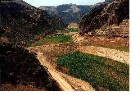
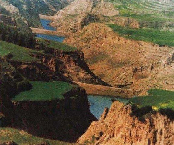
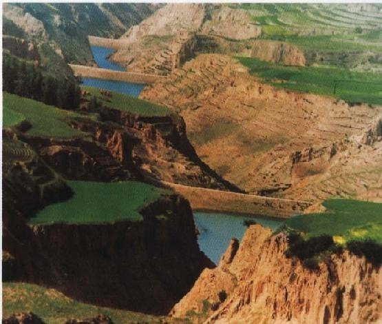
Falling water filled dams distribute widely in the middle reaches of the Yellow River, they are used to store water and wrap sediment which result from soil and water loss. On the Loess Plateau, in addition to the conditions of deep gully and steep slope, earth above the top of the dams can be used to build dams. First, soil is loosed with squirt guns, exploded or manually dug. Then, water is pumped up to the loose earth so as to rush the soil down along transporting ditch, turning the soil into dense mud to dam level surrounded by tamped banks. Under the press of gravity, the mud dehydrates, consolidates and becomes uniformly dense body of the dams. Compared with dams in other areas, the water power filled dams in the Yellow River basin are characterized by much denser mud, uniform particles and body texture, smaller transect of dams body, and wide applicability to soil materials such as sand soil, loess soil and weathering residue. The types of dams have widely applied to build moderate and small reservoirs and silt arresters in the middle reaches of the Yellow River, they play an important role in increase in agricultural production and reduction of sediment into the Yellow River.
2.3 Photos of the Technology
Media Gallery
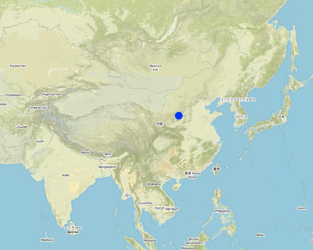
2.5 Country/ region/ locations where the Technology has been applied and which are covered by this assessment
Country:
China
Region/ State/ Province:
Shanxi, Shaanxi, etc.
Specify the spread of the Technology:
- evenly spread over an area
If the Technology is evenly spread over an area, specify area covered (in km2):
13062.0
If precise area is not known, indicate approximate area covered:
- > 10,000 km2
Comments:
Total area covered by the SLM Technology is 13062 km2.
Dams filled by water power are applied mainly in the middle reach of the Yellow River, including the provinces of Shanxi, Shaanxi, Inner Mongolia, Ningxia, Gansu, Qinghai, Henan, etc. The types of dams were used since 1950s, and most the dams being used were built in 1970s.
Map
×2.6 Date of implementation
If precise year is not known, indicate approximate date:
- more than 50 years ago (traditional)
2.7 Introduction of the Technology
Specify how the Technology was introduced:
- as part of a traditional system (> 50 years)
Comments (type of project, etc.):
The technology was developed by local people during the conservation practice in 1950s.
3. Classification of the SLM Technology
3.1 Main purpose(s) of the Technology
- improve production
3.2 Current land use type(s) where the Technology is applied

Cropland
- Annual cropping
Number of growing seasons per year:
- 1
Specify:
Longest growing period in days: 165Longest growing period from month to month: May - Sep

Waterways, waterbodies, wetlands
- Ponds, dams
Main products/ services:
Auto-Flowing Slurry Dam
Comments:
Major land use problems (compiler’s opinion): 1. Slope land is used as cropland
2. Too little ground cover to protect soil from erosion
3. Over grazing in wind erosion area
Major land use problems (land users’ perception): 1. Little cropland for food supply
2. The land productivity is too low
3. The benefit of returning cropland to graze land or woodland is not definite now except the compensate from government
3.5 SLM group to which the Technology belongs
- irrigation management (incl. water supply, drainage)
3.6 SLM measures comprising the Technology

structural measures
- S5: Dams, pans, ponds
Comments:
Main measures: structural measures
3.7 Main types of land degradation addressed by the Technology

soil erosion by water
- Wt: loss of topsoil/ surface erosion
- Wg: gully erosion/ gullying

soil erosion by wind
- Et: loss of topsoil

chemical soil deterioration
- Cn: fertility decline and reduced organic matter content (not caused by erosion)

water degradation
- Ha: aridification
Comments:
Main type of degradation addressed: Wg: gully erosion / gullying, Ha: aridification
Secondary types of degradation addressed: Wt: loss of topsoil / surface erosion, Et: loss of topsoil, Cn: fertility decline and reduced organic matter content
Main causes of degradation: other natural causes (avalanches, volcanic eruptions, mud flows, highly susceptible natural resources, extreme topography, etc.) specify, poverty / wealth (Lack of captial), education, access to knowledge and support services (Lack of knowledge)
3.8 Prevention, reduction, or restoration of land degradation
Specify the goal of the Technology with regard to land degradation:
- not applicable
4. Technical specifications, implementation activities, inputs, and costs
4.1 Technical drawing of the Technology
Technical specifications (related to technical drawing):
Technical knowledge required for field staff / advisors: low
Technical knowledge required for land users: low
Main technical functions: control of concentrated runoff: retain / trap, water harvesting / increase water supply, sediment retention / trapping, sediment harvesting
Secondary technical functions: control of raindrop splash, control of dispersed runoff: retain / trap, control of dispersed runoff: impede / retard, control of concentrated runoff: impede / retard, control of concentrated runoff: drain / divert, reduction of slope angle, reduction of slope length, improvement of ground cover, increase of surface roughness, increase in organic matter, increase of infiltration, increase / maintain water stored in soil, water spreading, reduction in wind speed, increase in soil fertility, improvement of soil structure
Construction material (earth): Loess earth
Slope (which determines the spacing indicated above): 45%
If the original slope has changed as a result of the Technology, the slope today is: 30%
Lateral gradient along the structure: 60%
For water harvesting: the ratio between the area where the harvested water is applied and the total area from which water is collected is: 1:1
4.2 General information regarding the calculation of inputs and costs
Specify currency used for cost calculations:
- USD
Indicate average wage cost of hired labour per day:
3.00
4.3 Establishment activities
| Activity | Timing (season) | |
|---|---|---|
| 1. | preparing earth | n/a |
| 2. | pumping water | n/a |
| 3. | preparing base of the dam and its perimetric banks | n/a |
| 4. | Flushing the prepared earth with water inside the banks of the dam | 0.1~1 |
| 5. | After dehydration and consolidation of the earth, repeat 3 and 4. | n/a |
4.4 Costs and inputs needed for establishment
Comments:
Duration of establishment phase: 540 month(s)
4.5 Maintenance/ recurrent activities
| Activity | Timing/ frequency | |
|---|---|---|
| 1. | Keeping the top of the dam level and free of crevice, water or rubbish | timely |
| 2. | Keeping the top of the dam level and free of crevice, water or rubbish | |
| 3. | Keeping the slope of the dam compact and free of rill or weed. | timely |
| 4. | Keeping the slope of the dam compact and free of rill or weed. | |
| 5. | Keeping the observation equipment work in order. | timely |
| 6. | Keeping the observation equipment work in order. | |
| 7. | Preventing the base the dam from destroying by white ants and other animals. | April to October/once a year |
4.6 Costs and inputs needed for maintenance/ recurrent activities (per year)
Comments:
The volume of structure.
4.7 Most important factors affecting the costs
Describe the most determinate factors affecting the costs:
Since the dam construction uses local materials, the most important factors affecting the cost are labor and equipment
5. Natural and human environment
5.1 Climate
Annual rainfall
- < 250 mm
- 251-500 mm
- 501-750 mm
- 751-1,000 mm
- 1,001-1,500 mm
- 1,501-2,000 mm
- 2,001-3,000 mm
- 3,001-4,000 mm
- > 4,000 mm
Agro-climatic zone
- semi-arid
- arid
5.2 Topography
Slopes on average:
- flat (0-2%)
- gentle (3-5%)
- moderate (6-10%)
- rolling (11-15%)
- hilly (16-30%)
- steep (31-60%)
- very steep (>60%)
Landforms:
- plateau/plains
- ridges
- mountain slopes
- hill slopes
- footslopes
- valley floors
Altitudinal zone:
- 0-100 m a.s.l.
- 101-500 m a.s.l.
- 501-1,000 m a.s.l.
- 1,001-1,500 m a.s.l.
- 1,501-2,000 m a.s.l.
- 2,001-2,500 m a.s.l.
- 2,501-3,000 m a.s.l.
- 3,001-4,000 m a.s.l.
- > 4,000 m a.s.l.
Indicate if the Technology is specifically applied in:
- not relevant
Comments and further specifications on topography:
Landform: Also plateau/plain
5.3 Soils
Soil depth on average:
- very shallow (0-20 cm)
- shallow (21-50 cm)
- moderately deep (51-80 cm)
- deep (81-120 cm)
- very deep (> 120 cm)
Soil texture (topsoil):
- medium (loamy, silty)
- fine/ heavy (clay)
Topsoil organic matter:
- medium (1-3%)
- low (<1%)
If available, attach full soil description or specify the available information, e.g. soil type, soil PH/ acidity, Cation Exchange Capacity, nitrogen, salinity etc.
Soil fertility: low
Soil drainage / infiltration: medium - good
Soil water storage capacity: high - very high
5.6 Characteristics of land users applying the Technology
Off-farm income:
- 10-50% of all income
Relative level of wealth:
- average
- rich
Indicate other relevant characteristics of the land users:
Population density: 50-100 persons/km2
Annual population growth: 0.5% - 1%
Relative level of wealth: rich, average, poor
There are almost no people very rich in the area.
Rich people are as same as average people.
40% of the land users are average wealthy and own 20% of the land (Average people in the area where the SWC is applied should offer labor for the construction.).
Poor people can offer labor for the construction.
Very poor people are relatively rare and they are often in poor health.
Off-farm income specification: Most young male farmers often go to the city or town to earn money
5.8 Land ownership, land use rights, and water use rights
Land ownership:
- state
Land use rights:
- open access (unorganized)
- communal (organized)
6. Impacts and concluding statements
6.1 On-site impacts the Technology has shown
Ecological impacts
Water cycle/ runoff
surface runoff
Quantity before SLM:
43
Quantity after SLM:
35
Soil
soil loss
Quantity before SLM:
80
Quantity after SLM:
21
6.4 Cost-benefit analysis
How do the benefits compare with the establishment costs (from land users’ perspective)?
Short-term returns:
positive
Long-term returns:
very positive
How do the benefits compare with the maintenance/ recurrent costs (from land users' perspective)?
Short-term returns:
positive
Long-term returns:
very positive
6.5 Adoption of the Technology
- 1-10%
If available, quantify (no. of households and/ or area covered):
80'000 households (3 percent of the area)
Of all those who have adopted the Technology, how many did so spontaneously, i.e. without receiving any material incentives/ payments?
- 11-50%
Comments:
5% of land user families have adopted the Technology with external material support
50000 land user families have adopted the Technology with external material support
Comments on acceptance with external material support: estimates
1% of land user families have adopted the Technology without any external material support
30000 land user families have adopted the Technology without any external material support
Comments on spontaneous adoption: estimates
There is a strong trend towards spontaneous adoption of the Technology
Comments on adoption trend: Although the local people adopt the SWC Technology willingly, it is usually invested, designed and constructed by the land owner, the local government.
7. References and links
7.1 Methods/ sources of information
7.2 References to available publications
Title, author, year, ISBN:
Special Planning Of Soil And Water Conservation in Xinzhou Region , Shanxi Province. 1986-1990.
Available from where? Costs?
Library of the Resource and Environmental Department, Beijing Normal University.
Title, author, year, ISBN:
How to design the dry masonry dam in the Hanjiachuan watershed. Tianyuzhu, Wangzuliang. Beijing. Water conservation in Beijing. 2000.
Available from where? Costs?
Library of the Resource and Environmental Department, Beijing Normal University.
Links and modules
Expand all Collapse allLinks
Falling Water Dam [China]
The falling water dams are widely built in the middle reach of the Yellow River, the typical dams are filled with dense slurry by water flow from upland. The approach is implemented mainly by government investment.
- Compiler: Yan ZHANG
Modules
No modules