Auto-Flowing Slurry Dam [จีน]
- ผู้สร้างสรรค์:
- การอัพเดท:
- ผู้รวบรวม: Yan ZHANG
- ผู้เรียบเรียง: –
- ผู้ตรวจสอบ: David Streiff, Alexandra Gavilano
Falling Water Dam
technologies_1364 - จีน
ดูส่วนย่อย
ขยายทั้งหมด ย่อทั้งหมด1. ข้อมูลทั่วไป
1.2 รายละเอียดที่ติดต่อได้ของผู้รวบรวมและองค์กรที่เกี่ยวข้องในการประเมินและการจัดเตรียมทำเอกสารของเทคโนโลยี
ชื่อขององค์กรซึ่งอำนวยความสะดวกในการทำเอกสารหรือการประเมินเทคโนโลยี (ถ้าเกี่ยวข้อง)
Department of Resources and Environmental Science, Beijing Normal University (Department of Resources and Environmental Science, Beijing Normal University) - จีน1.3 เงื่อนไขการใช้ข้อมูลที่ได้บันทึกผ่านทาง WOCAT
ผู้รวบรวมและวิทยากรหลักยอมรับเงื่อนไขเกี่ยวกับการใช้ข้อมูลที่ถูกบันทึกผ่านทาง WOCAT:
ใช่
1.5 Reference to Questionnaire(s) on SLM Approaches (documented using WOCAT)
Falling Water Dam [จีน]
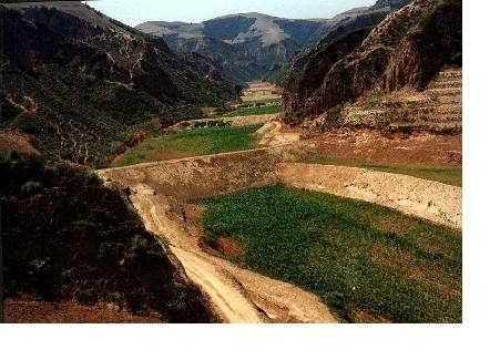
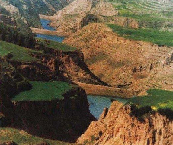
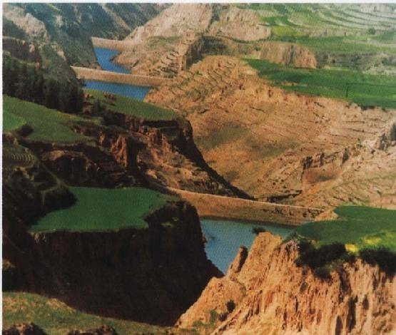
The falling water dams are widely built in the middle reach of the Yellow River, the typical dams are filled with dense slurry by water flow from upland. The approach is implemented mainly by government investment.
- ผู้รวบรวม: Yan ZHANG
2. การอธิบายลักษณะของเทคโนโลยี SLM
2.1 การอธิบายแบบสั้น ๆ ของเทคโนโลยี
คำจำกัดความของเทคโนโลยี:
Auto-flowing slurry dams is filled with dense slurry by water flow from upland to maintain eroded soil particles and runoff.
2.2 การอธิบายแบบละเอียดของเทคโนโลยี
คำอธิบาย:
Falling water filled dams distribute widely in the middle reaches of the Yellow River, they are used to store water and wrap sediment which result from soil and water loss. On the Loess Plateau, in addition to the conditions of deep gully and steep slope, earth above the top of the dams can be used to build dams. First, soil is loosed with squirt guns, exploded or manually dug. Then, water is pumped up to the loose earth so as to rush the soil down along transporting ditch, turning the soil into dense mud to dam level surrounded by tamped banks. Under the press of gravity, the mud dehydrates, consolidates and becomes uniformly dense body of the dams. Compared with dams in other areas, the water power filled dams in the Yellow River basin are characterized by much denser mud, uniform particles and body texture, smaller transect of dams body, and wide applicability to soil materials such as sand soil, loess soil and weathering residue. The types of dams have widely applied to build moderate and small reservoirs and silt arresters in the middle reaches of the Yellow River, they play an important role in increase in agricultural production and reduction of sediment into the Yellow River.
2.3 รูปภาพของเทคโนโลยี
อัลบั้มสื่อบันทึก
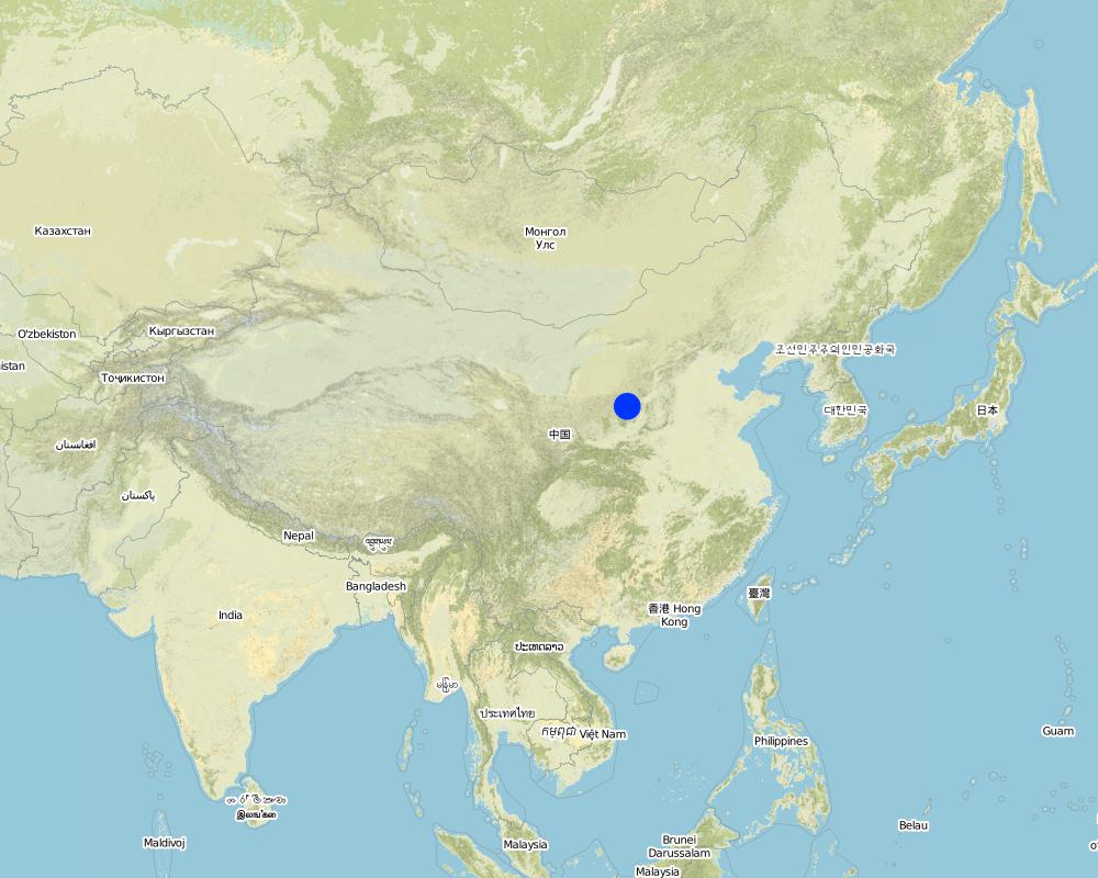
2.5 ประเทศภูมิภาค หรือสถานที่ตั้งที่เทคโนโลยีได้นำไปใช้และได้รับการครอบคลุมโดยการประเมินนี้
ประเทศ:
จีน
ภูมิภาค/รัฐ/จังหวัด:
Shanxi, Shaanxi, etc.
ระบุการกระจายตัวของเทคโนโลยี:
- กระจายไปอย่างสม่ำเสมอในพื้นที่
If the Technology is evenly spread over an area, specify area covered (in km2):
13062.0
If precise area is not known, indicate approximate area covered:
- > 10,000 ตร.กม.
แสดงความคิดเห็น:
Total area covered by the SLM Technology is 13062 km2.
Dams filled by water power are applied mainly in the middle reach of the Yellow River, including the provinces of Shanxi, Shaanxi, Inner Mongolia, Ningxia, Gansu, Qinghai, Henan, etc. The types of dams were used since 1950s, and most the dams being used were built in 1970s.
Map
×2.6 วันที่การดำเนินการ
ถ้าไม่รู้ปีที่แน่นอน ให้ระบุวันที่โดยประมาณ:
- มากกว่า 50 ปี (แบบดั้งเดิม)
2.7 คำแนะนำของเทคโนโลยี
ให้ระบุว่าเทคโนโลยีถูกแนะนำเข้ามาอย่างไร:
- เป็นส่วนหนึ่งของระบบแบบดั้งเดิมที่ทำก้นอยู่ (> 50 ปี)
ความคิดเห็น (ประเภทของโครงการ เป็นต้น) :
The technology was developed by local people during the conservation practice in 1950s.
3. การจัดประเภทของเทคโนโลยี SLM
3.1 วัตถุประสงค์หลักของเทคโนโลยี
- ปรับปรุงการผลิตให้ดีขึ้น
3.2 ประเภทของการใช้ที่ดินในปัจจุบันที่ได้นำเทคโนโลยีไปใช้

พื้นที่ปลูกพืช
- การปลูกพืชล้มลุกอายุปีเดียว
จำนวนของฤดูเพาะปลูกต่อปี:
- 1
ระบุ:
Longest growing period in days: 165Longest growing period from month to month: May - Sep

ทางน้ำ แหล่งน้ำ พื้นที่ชุ่มน้ำ
- บ่อน้ำ เขื่อน
ผลิตภัณฑ์หลักหรือบริการ:
Auto-Flowing Slurry Dam
แสดงความคิดเห็น:
Major land use problems (compiler’s opinion): 1. Slope land is used as cropland
2. Too little ground cover to protect soil from erosion
3. Over grazing in wind erosion area
Major land use problems (land users’ perception): 1. Little cropland for food supply
2. The land productivity is too low
3. The benefit of returning cropland to graze land or woodland is not definite now except the compensate from government
3.5 กลุ่ม SLM ที่ตรงกับเทคโนโลยีนี้
- การจัดการด้านชลประทาน (รวมถึงการลำเลียงส่งน้ำ การระบายน้ำ)
3.6 มาตรการ SLM ที่ประกอบกันเป็นเทคโนโลยี

มาตรการอนุรักษ์ด้วยโครงสร้าง
- S5: เขื่อน ชั้นดินที่แน่นแข็งบ่อน้ำ
แสดงความคิดเห็น:
Main measures: structural measures
3.7 รูปแบบหลักของการเสื่อมโทรมของที่ดินที่ได้รับการแก้ไขโดยเทคโนโลยี

การกัดกร่อนของดินโดยน้ำ
- Wt (Loss of topsoil): การสูญเสียดินชั้นบนหรือการกัดกร่อนที่ผิวดิน
- Wg (Gully erosion): การกัดกร่อนแบบร่องธารหรือการทำให้เกิดร่องน้ำเซาะ

การกัดกร่อนของดินโดยลม
- Et (Loss of topsoil): การสูญเสียดินชั้นบน

การเสื่อมโทรมของดินทางด้านเคมี
- Cn (Fertility decline): ความอุดมสมบูรณ์และปริมาณอินทรียวัตถุในดินถูกทำให้ลดลงไป (ไม่ได้เกิดจากสาเหตุการกัดกร่อน)

การเสื่อมโทรมของน้ำ
- Ha (Aridification): การเกิดความแห้งแล้ง
แสดงความคิดเห็น:
Main type of degradation addressed: Wg: gully erosion / gullying, Ha: aridification
Secondary types of degradation addressed: Wt: loss of topsoil / surface erosion, Et: loss of topsoil, Cn: fertility decline and reduced organic matter content
Main causes of degradation: other natural causes (avalanches, volcanic eruptions, mud flows, highly susceptible natural resources, extreme topography, etc.) specify, poverty / wealth (Lack of captial), education, access to knowledge and support services (Lack of knowledge)
3.8 การป้องกัน การลดลง หรือการฟื้นฟูความเสื่อมโทรมของที่ดิน
ระบุเป้าหมายของเทคโนโลยีกับความเสื่อมโทรมของที่ดิน:
- ไม่สามารถใช้ได้
4. ข้อมูลจำเพาะด้านเทคนิค กิจกรรมการนำไปปฏิบัติใช้ ปัจจัยนำเข้า และค่าใช้จ่าย
4.1 แบบแปลนทางเทคนิคของเทคโนโลยี
ข้อมูลจำเพาะด้านเทคนิค (แบบแปลนทางเทคนิคของเทคโนโลยี):
Technical knowledge required for field staff / advisors: low
Technical knowledge required for land users: low
Main technical functions: control of concentrated runoff: retain / trap, water harvesting / increase water supply, sediment retention / trapping, sediment harvesting
Secondary technical functions: control of raindrop splash, control of dispersed runoff: retain / trap, control of dispersed runoff: impede / retard, control of concentrated runoff: impede / retard, control of concentrated runoff: drain / divert, reduction of slope angle, reduction of slope length, improvement of ground cover, increase of surface roughness, increase in organic matter, increase of infiltration, increase / maintain water stored in soil, water spreading, reduction in wind speed, increase in soil fertility, improvement of soil structure
Construction material (earth): Loess earth
Slope (which determines the spacing indicated above): 45%
If the original slope has changed as a result of the Technology, the slope today is: 30%
Lateral gradient along the structure: 60%
For water harvesting: the ratio between the area where the harvested water is applied and the total area from which water is collected is: 1:1
4.2 ข้อมูลทั่วไปเกี่ยวกับการคำนวณปัจจัยนำเข้าและค่าใช้จ่าย
ระบุสกุลเงินที่ใช้คำนวณค่าใช้จ่าย:
- USD
ระบุค่าเฉลี่ยของค่าจ้างในการจ้างแรงงานต่อวัน:
3.00
4.3 กิจกรรมเพื่อการจัดตั้ง
| กิจกรรม | Timing (season) | |
|---|---|---|
| 1. | preparing earth | n/a |
| 2. | pumping water | n/a |
| 3. | preparing base of the dam and its perimetric banks | n/a |
| 4. | Flushing the prepared earth with water inside the banks of the dam | 0.1~1 |
| 5. | After dehydration and consolidation of the earth, repeat 3 and 4. | n/a |
4.4 ค่าใช้จ่ายของปัจจัยนำเข้าที่จำเป็นสำหรับการจัดตั้ง
แสดงความคิดเห็น:
Duration of establishment phase: 540 month(s)
4.5 การบำรุงรักษาสภาพหรือกิจกรรมที่เกิดขึ้นเป็นประจำ
| กิจกรรม | ช่วงระยะเวลา/ความถี่ | |
|---|---|---|
| 1. | Keeping the top of the dam level and free of crevice, water or rubbish | timely |
| 2. | Keeping the top of the dam level and free of crevice, water or rubbish | |
| 3. | Keeping the slope of the dam compact and free of rill or weed. | timely |
| 4. | Keeping the slope of the dam compact and free of rill or weed. | |
| 5. | Keeping the observation equipment work in order. | timely |
| 6. | Keeping the observation equipment work in order. | |
| 7. | Preventing the base the dam from destroying by white ants and other animals. | April to October/once a year |
4.6 ค่าใช้จ่ายของปัจจัยนำเข้าและกิจกรรมที่เกิดขึ้นเป็นประจำที่ต้องการการบำรุงรักษา (ต่อปี)
แสดงความคิดเห็น:
The volume of structure.
4.7 ปัจจัยสำคัญที่สุดที่มีผลกระทบต่อค่าใช้จ่าย
ปัจจัยสำคัญที่สุดที่มีผลกระทบต่อค่าใช้จ่ายต่างๆ:
Since the dam construction uses local materials, the most important factors affecting the cost are labor and equipment
5. สิ่งแวดล้อมทางธรรมชาติและของมนุษย์
5.1 ภูมิอากาศ
ฝนประจำปี
- < 250 ม.ม.
- 251-500 ม.ม.
- 501-750 ม.ม.
- 751-1,000 ม.ม.
- 1,001-1,500 ม.ม.
- 1,501-2,000 ม.ม.
- 2,001-3,000 ม.ม.
- 3,001-4,000 ม.ม.
- > 4,000 ม.ม.
เขตภูมิอากาศเกษตร
- กึ่งแห้งแล้ง
- แห้งแล้ง
5.2 สภาพภูมิประเทศ
ค่าเฉลี่ยความลาดชัน:
- ราบเรียบ (0-2%)
- ลาดที่ไม่ชัน (3-5%)
- ปานกลาง (6-10%)
- เป็นลูกคลื่น (11-15%)
- เป็นเนิน (16-30%)
- ชัน (31-60%)
- ชันมาก (>60%)
ธรณีสัณฐาน:
- ที่ราบสูง/ที่ราบ
- สันเขา
- ไหล่เขา
- ไหล่เนินเขา
- ตีนเนิน
- หุบเขา
ระดับความสูง:
- 0-100 เมตร
- 101-500 เมตร
- 501-1,000 เมตร
- 1,001-1,500 เมตร
- 1,501-2,000 เมตร
- 2,001-2,500 เมตร
- 2,501-3,000 เมตร
- 3,001-4,000 เมตร
- > 4,000 เมตร
ให้ระบุถ้าเทคโนโลยีได้ถูกนำไปใช้:
- ไม่เกี่ยวข้อง
ความคิดเห็นและข้อมูลจำเพาะเพิ่มเติมเรื่องสภาพภูมิประเทศ:
Landform: Also plateau/plain
5.3 ดิน
ค่าเฉลี่ยความลึกของดิน:
- ตื้นมาก (0-20 ซ.ม.)
- ตื้น (21-50 ซ.ม.)
- ลึกปานกลาง (51-80 ซ.ม.)
- ลึก (81-120 ซ.ม.)
- ลึกมาก (>120 ซ.ม.)
เนื้อดิน (ดินชั้นบน):
- ปานกลาง (ดินร่วน ทรายแป้ง)
- ละเอียด/หนัก (ดินเหนียว)
อินทรียวัตถุในดิน:
- ปานกลาง (1-3%)
- ต่ำ (<1%)
(ถ้ามี) ให้แนบคำอธิบายเรื่องดินแบบเต็มหรือระบุข้อมูลที่มีอยู่ เช่น ชนิดของดิน ค่า pH ของดินหรือความเป็นกรดของดิน ความสามารถในการแลกเปลี่ยนประจุบวก ไนโตรเจน ความเค็ม เป็นต้น:
Soil fertility: low
Soil drainage / infiltration: medium - good
Soil water storage capacity: high - very high
5.6 ลักษณะของผู้ใช้ที่ดินที่นำเทคโนโลยีไปปฏิบัติใช้
รายได้ที่มาจากนอกฟาร์ม:
- 10-50% ของรายได้ทั้งหมด
ระดับของความมั่งคั่งโดยเปรียบเทียบ:
- พอมีพอกิน
- รวย
ระบุลักษณะอื่นๆที่เกี่ยวข้องของผู้ใช้ที่ดิน:
Population density: 50-100 persons/km2
Annual population growth: 0.5% - 1%
Relative level of wealth: rich, average, poor
There are almost no people very rich in the area.
Rich people are as same as average people.
40% of the land users are average wealthy and own 20% of the land (Average people in the area where the SWC is applied should offer labor for the construction.).
Poor people can offer labor for the construction.
Very poor people are relatively rare and they are often in poor health.
Off-farm income specification: Most young male farmers often go to the city or town to earn money
5.8 กรรมสิทธิ์ในที่ดิน สิทธิในการใช้ที่ดินและสิทธิในการใช้น้ำ
กรรมสิทธิ์ในที่ดิน:
- รัฐ
สิทธิในการใช้ที่ดิน:
- เข้าถึงได้แบบเปิด (ไม่ได้จัดระเบียบ)
- เกี่ยวกับชุมชน (ถูกจัดระเบียบ)
6. ผลกระทบและสรุปคำบอกกล่าว
6.1 ผลกระทบในพื้นที่ดำเนินการ (On-site) จากการใช้เทคโนโลยี
ผลกระทบด้านนิเวศวิทยา
วัฐจักรน้ำหรือน้ำบ่า
น้ำไหลบ่าที่ผิวดิน
จำนวนก่อน SLM:
43
หลังจาก SLM:
35
ดิน
การสูญเสียดิน
จำนวนก่อน SLM:
80
หลังจาก SLM:
21
6.4 การวิเคราะห์ค่าใช้จ่ายและผลประโยชน์ที่ได้รับ
ผลประโยชน์ที่ได้รับเปรียบเทียบกับค่าใช้จ่ายในการจัดตั้งเป็นอย่างไร (จากมุมมองของผู้ใช้ที่ดิน)
ผลตอบแทนระยะสั้น:
ด้านบวก
ผลตอบแทนระยะยาว:
ด้านบวกอย่างมาก
ผลประโยชน์ที่ได้รับเปรียบเทียบกับค่าใช้จ่ายในการบำรุงรักษาหรือต้นทุนที่เกิดขึ้นซ้ำอีก เป็นอย่างไร (จากมุมมองของผู้ใช้ที่ดิน)
ผลตอบแทนระยะสั้น:
ด้านบวก
ผลตอบแทนระยะยาว:
ด้านบวกอย่างมาก
6.5 การปรับตัวของเทคโนโลยี
- 1-10%
ถ้ามีข้อมูลให้บอกปริมาณด้วย (จำนวนของครัวเรือนหรือครอบคลุมพื้นที่):
80'000 households (3 percent of the area)
Of all those who have adopted the Technology, how many did so spontaneously, i.e. without receiving any material incentives/ payments?
- 11-50%
แสดงความคิดเห็น:
5% of land user families have adopted the Technology with external material support
50000 land user families have adopted the Technology with external material support
Comments on acceptance with external material support: estimates
1% of land user families have adopted the Technology without any external material support
30000 land user families have adopted the Technology without any external material support
Comments on spontaneous adoption: estimates
There is a strong trend towards spontaneous adoption of the Technology
Comments on adoption trend: Although the local people adopt the SWC Technology willingly, it is usually invested, designed and constructed by the land owner, the local government.
7. การอ้างอิงและการเชื่อมต่อ
7.1 วิธีการและแหล่งข้อมูล
7.2 การอ้างอิงถึงสิ่งตีพิมพ์
หัวข้อ, ผู้เขียน, ปี, หมายเลข ISBN:
Special Planning Of Soil And Water Conservation in Xinzhou Region , Shanxi Province. 1986-1990.
ชื่อเรื่อง ผู้เขียน ปี ISBN:
Library of the Resource and Environmental Department, Beijing Normal University.
หัวข้อ, ผู้เขียน, ปี, หมายเลข ISBN:
How to design the dry masonry dam in the Hanjiachuan watershed. Tianyuzhu, Wangzuliang. Beijing. Water conservation in Beijing. 2000.
ชื่อเรื่อง ผู้เขียน ปี ISBN:
Library of the Resource and Environmental Department, Beijing Normal University.
ลิงก์และโมดูล
ขยายทั้งหมด ย่อทั้งหมดลิงก์
Falling Water Dam [จีน]
The falling water dams are widely built in the middle reach of the Yellow River, the typical dams are filled with dense slurry by water flow from upland. The approach is implemented mainly by government investment.
- ผู้รวบรวม: Yan ZHANG
โมดูล
ไม่มีโมดูล