Riparian forest to improve riverbank stabilization [Kenya]
- Creation:
- Update:
- Compiler: Manuel Fischer
- Editor: –
- Reviewers: David Streiff, Alexandra Gavilano
technologies_1567 - Kenya
View sections
Expand all Collapse all1. General information
1.2 Contact details of resource persons and institutions involved in the assessment and documentation of the Technology
land user:
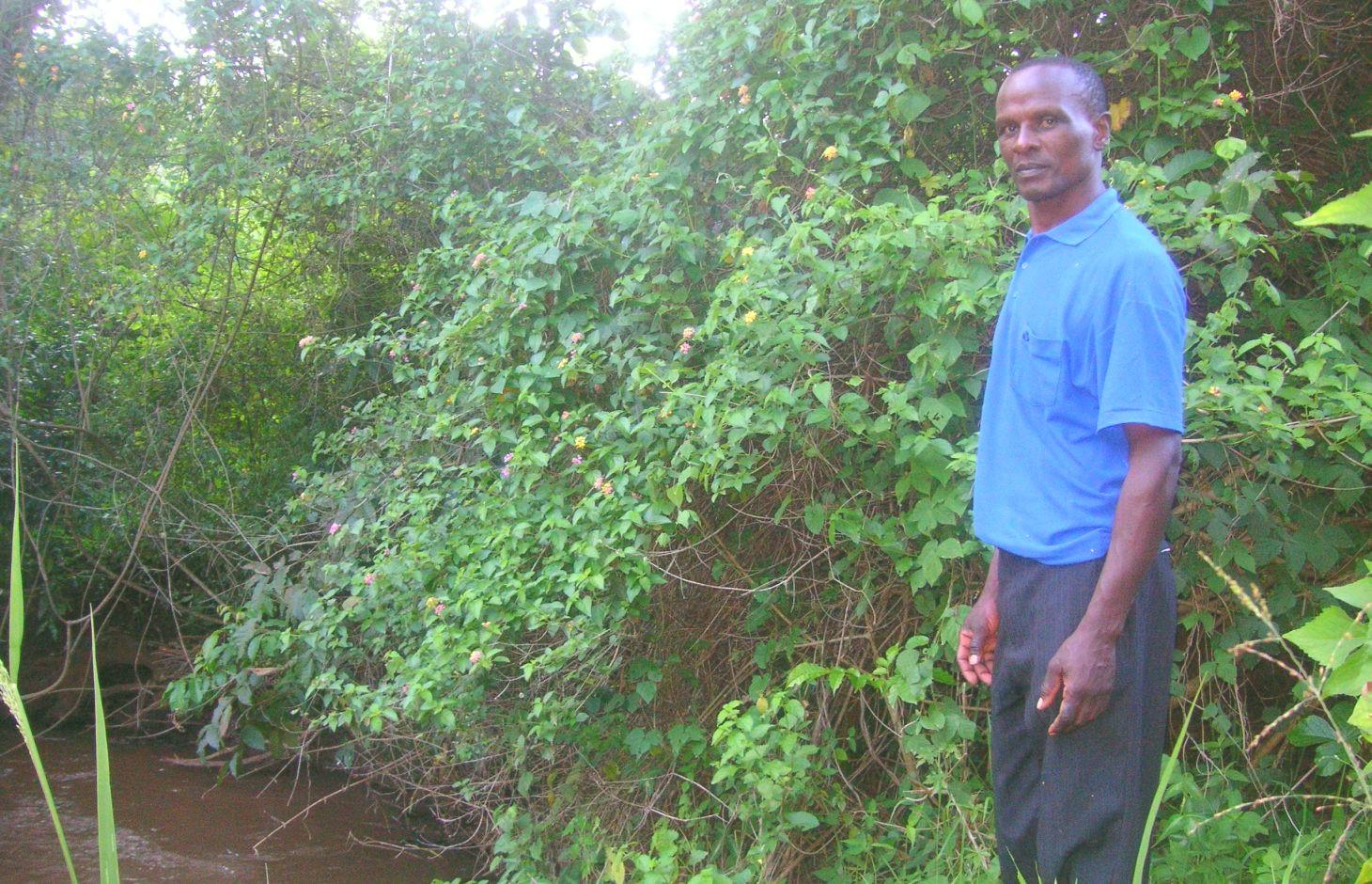
Njiru Fredrick
Kenya
Name of the institution(s) which facilitated the documentation/ evaluation of the Technology (if relevant)
CDE Centre for Development and Environment (CDE Centre for Development and Environment) - Switzerland1.3 Conditions regarding the use of data documented through WOCAT
The compiler and key resource person(s) accept the conditions regarding the use of data documented through WOCAT:
Yes
2. Description of the SLM Technology
2.1 Short description of the Technology
Definition of the Technology:
Protection of the riparian zone at Kapingazi River by leaving it undisturbed of human interference
2.2 Detailed description of the Technology
Description:
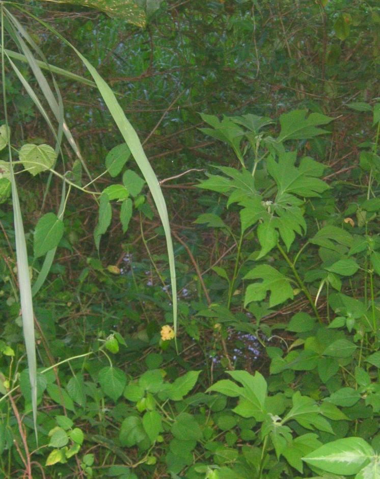
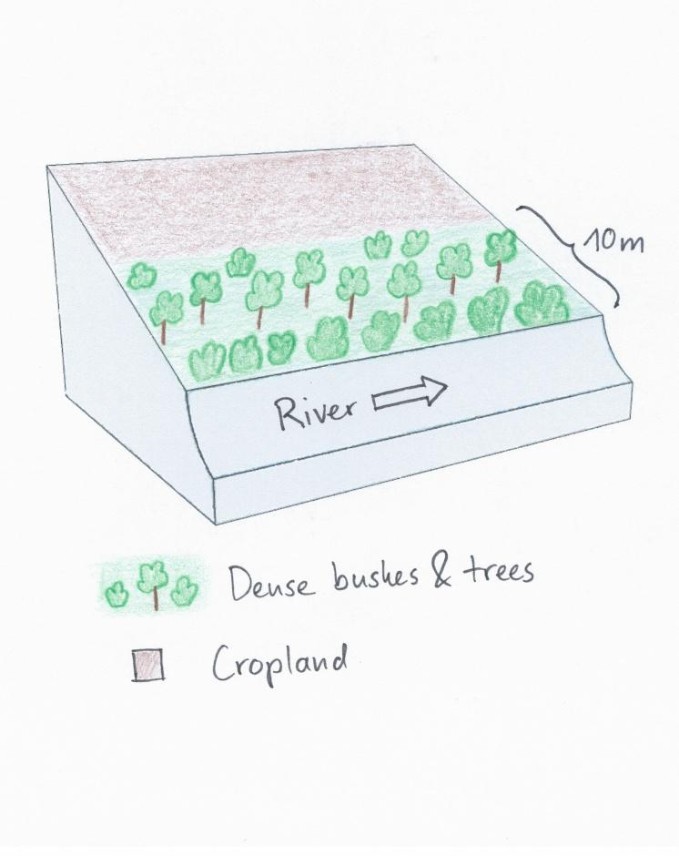
The farmers’ land plot is situated right alongside the river. Heavy floods have eroded a major part of the riverbank and have led to crop failures on the arable land. The farmer reacted to the degradation by stopping agriculture activities on a certain riparian area in order to enable natural vegetation to reclaim the area. The idea is that during the next years, further floods will deposit sediments, which will increase the elevation and fertility of the plot. As soon as enough soil has accumulated and the elevation has increased enough, the farmer wants to plant French beans in the area. Trees were planted in the riparian zone to stabilize the riverbank and to ensure water quality in the river by retaining sediments from nearby fields. Agricultural chemicals are trapped in the riparian buffer as well.
Purpose of the Technology: The purpose is to deal with the regular floods of Kapingazi River and to gain advantages for the farmer and the environmental conditions. Floods are a natural event and happen regularly, therefore strategies are necessary to diminish their negative effects. Furthermore, the human impact on a riparian ecosystem should be kept as small as possible by trapping chemicals and sediments that reduce water quality for down streamers.
Establishment / maintenance activities and inputs: The area where sediments are trapped is not touched by any human interference, the vegetation grows in its natural way. The stabilizing trees of the riparian are planted at the beginning of the rainy season in March or October. Dead seedlings have to be replaced regularly.
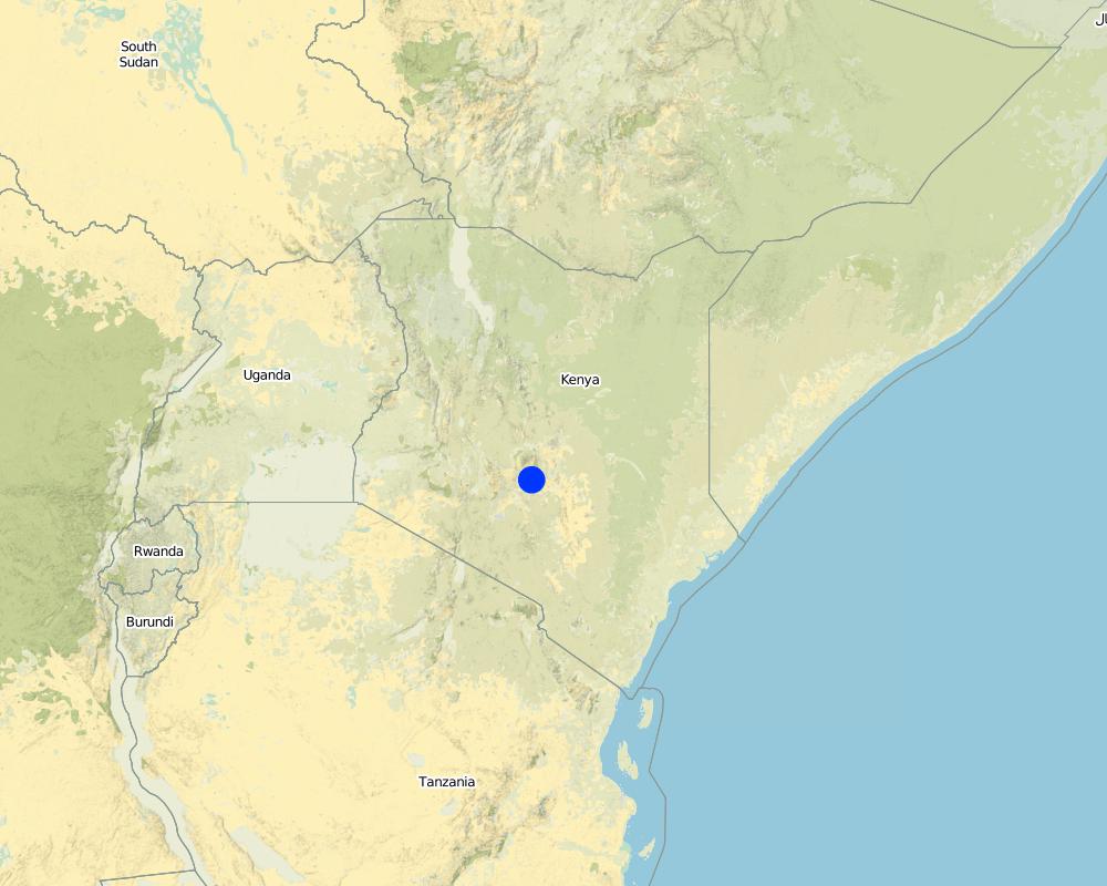
Natural / human environment: Kapingazi River is situated at the south eastern face of Mt. Kenya.It is an agriculturally favourable place due to abundant and reliable rainfall and fertile soils. The studied plot is located at an elevation of 1295 m.a.s.l where mainly maize and vegetables are cultivated. The precipitation amounts to 1150mm a year. Due to the good conditions, this area experiences a steady increase in both population growth and population density.
2.3 Photos of the Technology
Media Gallery
2.5 Country/ region/ locations where the Technology has been applied and which are covered by this assessment
Country:
Kenya
Region/ State/ Province:
Kenya/Eastern Province
Further specification of location:
Embu West
Specify the spread of the Technology:
- evenly spread over an area
If precise area is not known, indicate approximate area covered:
- < 0.1 km2 (10 ha)
Comments:
The area where the land use is applied locally is 10 acres. The farmer applies it on 2.5 acres on his 20 acres farm.
Map
×2.6 Date of implementation
If precise year is not known, indicate approximate date:
- less than 10 years ago (recently)
2.7 Introduction of the Technology
Specify how the Technology was introduced:
- through land users' innovation
Comments (type of project, etc.):
2 other people have introduced the same technology. Knowledge about riparian protection was also received through the water resource users association.
3. Classification of the SLM Technology
3.1 Main purpose(s) of the Technology
- reduce, prevent, restore land degradation
- reduce risk of disasters
3.2 Current land use type(s) where the Technology is applied

Cropland
- Annual cropping
- Tree and shrub cropping
Annual cropping - Specify crops:
- cereals - maize
- legumes and pulses - beans
- Mulinga (cordia africana), Moko (cordia monoica), Mokoego, Moo(Markhamia lutea), Muku (Aphananthe aspera), Mukuelgo, Muu
Number of growing seasons per year:
- 2
Specify:
Longest growing period in days: 60 Longest growing period from month to month: march to may Second longest growing period in days: 60 Second longest growing period from month to month: october to november

Forest/ woodlands
- (Semi-)natural forests/ woodlands
- pruning
Products and services:
- Timber
- Fuelwood
- Protection against natural hazards
Comments:
Trees/ shrubs species: Mulinga (cordia africana), Moko (cordia monoica), Mokoego, Moo(Markhamia lutea), Muku (Aphananthe aspera), Mukuelgo, Muu
Major land use problems (compiler’s opinion): Riverbank degradation and small riparian area.
Major land use problems (land users’ perception): Riverbank degradation and destroyed yield due to floods.
Other type of forest: pruning
Forest products and services: timber, fuelwood, protection against natural hazards
Future (final) land use (after implementation of SLM Technology): Forests / woodlands: Fn: Natural
3.3 Has land use changed due to the implementation of the Technology?
Has land use changed due to the implementation of the Technology?
- Yes (Please fill out the questions below with regard to the land use before implementation of the Technology)
Cropland
- Annual cropping
3.4 Water supply
Water supply for the land on which the Technology is applied:
- rainfed
3.5 SLM group to which the Technology belongs
- area closure (stop use, support restoration)
- surface water management (spring, river, lakes, sea)
3.6 SLM measures comprising the Technology

vegetative measures
- V1: Tree and shrub cover

management measures
- M1: Change of land use type
Comments:
Main measures: vegetative measures, management measures
Type of vegetative measures: aligned: -along boundary
3.7 Main types of land degradation addressed by the Technology

soil erosion by water
- Wr: riverbank erosion

biological degradation
- Bc: reduction of vegetation cover

water degradation
- Hp: decline of surface water quality
Comments:
Main type of degradation addressed: Wr: riverbank erosion, Hp: decline of surface water quality
Secondary types of degradation addressed: Bc: reduction of vegetation cover
Main causes of degradation: deforestation / removal of natural vegetation (incl. forest fires), over-exploitation of vegetation for domestic use, Heavy / extreme rainfall (intensity/amounts) (due to climate change?), floods, education, access to knowledge and support services (lack of education)
3.8 Prevention, reduction, or restoration of land degradation
Specify the goal of the Technology with regard to land degradation:
- prevent land degradation
- restore/ rehabilitate severely degraded land
4. Technical specifications, implementation activities, inputs, and costs
4.1 Technical drawing of the Technology
Technical specifications (related to technical drawing):
The riparian area was regularly affected by floods and riverbank erosion. The land user decided to stop cultivation which allows the development of riparian vegetation to stabilize the riverbank and to raise the elevation.
Location: Embu. Embu West / Eastern Province
Date: 28.12.2013
Technical knowledge required for field staff / advisors: moderate
Technical knowledge required for land users: moderate
Main technical functions: stabilisation of soil (eg by tree roots against land slides)
Secondary technical functions: improvement of ground cover, sediment retention / trapping, sediment harvesting, promotion of vegetation species and varieties (quality, eg palatable fodder)
Aligned: -along boundary
Number of plants per (ha): 33 on 450m
Vertical interval within rows / strips / blocks (m): 3-15
Trees/ shrubs species: Mulinga (cordia africana), Moko (cordia monoica), Mokoego, Moo(Markhamia lutea), Muku, Mukuelgo, Muu
Change of land use type: A plot of cropland was converted to a forest that consists mostly of dense bushes and trees.
Author:
Manuel Fischer
4.2 General information regarding the calculation of inputs and costs
Specify how costs and inputs were calculated:
- per Technology unit
Specify unit:
Riparian area
Specify dimensions of unit (if relevant):
450 m
Specify currency used for cost calculations:
- USD
Indicate average wage cost of hired labour per day:
2.70
4.3 Establishment activities
| Activity | Timing (season) | |
|---|---|---|
| 1. | Planting tree seedlings | During rainy season |
| 2. | Replant dead tree seedlings | During rainy season |
| 3. | change of land use |
4.4 Costs and inputs needed for establishment
| Specify input | Unit | Quantity | Costs per Unit | Total costs per input | % of costs borne by land users | |
|---|---|---|---|---|---|---|
| Labour | Planting tree seedlings | Persons/day | 2.0 | 3.5 | 7.0 | 100.0 |
| Labour | Replant dead tree seedlings | Persons/day | 2.0 | 3.5 | 7.0 | 100.0 |
| Plant material | Seedlings | pieces | 33.0 | 0.111 | 3.66 | 100.0 |
| Plant material | Seedlings for replanting | pieces | 12.0 | 0.111 | 1.33 | 100.0 |
| Total costs for establishment of the Technology | 18.99 | |||||
| Total costs for establishment of the Technology in USD | 18.99 | |||||
Comments:
Duration of establishment phase: 0.2 month(s)
4.6 Costs and inputs needed for maintenance/ recurrent activities (per year)
Comments:
Machinery/ tools: Jembe
The costs were calculated for a riparian area with a length of 100m and a width of 10m, since hectares are difficult to apply on a riparian context. The determinant factor for the costs is labour. In this case, the costs are very low because the trees were only planted every 10 metres along the riparian. The seedlings must be bought in a nursery. Most of the bushes regrow naturally and do not need any care.
Some of the seedlings had to be replanted, because they dried up. The required equipment like a spade is available on nearly every farm or can be borrowed from neighbours and is thus not added to the costs.
5. Natural and human environment
5.1 Climate
Annual rainfall
- < 250 mm
- 251-500 mm
- 501-750 mm
- 751-1,000 mm
- 1,001-1,500 mm
- 1,501-2,000 mm
- 2,001-3,000 mm
- 3,001-4,000 mm
- > 4,000 mm
Agro-climatic zone
- sub-humid
Thermal climate class: tropics
5.2 Topography
Slopes on average:
- flat (0-2%)
- gentle (3-5%)
- moderate (6-10%)
- rolling (11-15%)
- hilly (16-30%)
- steep (31-60%)
- very steep (>60%)
Landforms:
- plateau/plains
- ridges
- mountain slopes
- hill slopes
- footslopes
- valley floors
Altitudinal zone:
- 0-100 m a.s.l.
- 101-500 m a.s.l.
- 501-1,000 m a.s.l.
- 1,001-1,500 m a.s.l.
- 1,501-2,000 m a.s.l.
- 2,001-2,500 m a.s.l.
- 2,501-3,000 m a.s.l.
- 3,001-4,000 m a.s.l.
- > 4,000 m a.s.l.
Comments and further specifications on topography:
Altitudinal zone: 1298 m a.s.l.
5.3 Soils
Soil depth on average:
- very shallow (0-20 cm)
- shallow (21-50 cm)
- moderately deep (51-80 cm)
- deep (81-120 cm)
- very deep (> 120 cm)
Soil texture (topsoil):
- fine/ heavy (clay)
Topsoil organic matter:
- medium (1-3%)
If available, attach full soil description or specify the available information, e.g. soil type, soil PH/ acidity, Cation Exchange Capacity, nitrogen, salinity etc.
Soil fertility is high
Soil drainage / infiltration is medium
Soil water storage capacity is very high
5.4 Water availability and quality
Ground water table:
< 5 m
Availability of surface water:
good
Water quality (untreated):
for agricultural use only (irrigation)
Comments and further specifications on water quality and quantity:
Availability of surface water: Sometimes floods, during rains
5.5 Biodiversity
Species diversity:
- medium
5.6 Characteristics of land users applying the Technology
Market orientation of production system:
- mixed (subsistence/ commercial)
Off-farm income:
- less than 10% of all income
Relative level of wealth:
- rich
Individuals or groups:
- groups/ community
Level of mechanization:
- manual work
Gender:
- women
- men
Indicate other relevant characteristics of the land users:
Land users applying the Technology are mainly Leaders / privileged
Population density: > 500 persons/km2
5.7 Average area of land used by land users applying the Technology
- < 0.5 ha
- 0.5-1 ha
- 1-2 ha
- 2-5 ha
- 5-15 ha
- 15-50 ha
- 50-100 ha
- 100-500 ha
- 500-1,000 ha
- 1,000-10,000 ha
- > 10,000 ha
Is this considered small-, medium- or large-scale (referring to local context)?
- small-scale
Comments:
Average area of land owned or leased by land users applying the Technology: Also 5-15 ha for cropland and 0.5 - 1 ha for woodland
5.8 Land ownership, land use rights, and water use rights
Land ownership:
- individual, not titled
Land use rights:
- individual
Water use rights:
- communal (organized)
5.9 Access to services and infrastructure
health:
- poor
- moderate
- good
education:
- poor
- moderate
- good
technical assistance:
- poor
- moderate
- good
employment (e.g. off-farm):
- poor
- moderate
- good
markets:
- poor
- moderate
- good
energy:
- poor
- moderate
- good
roads and transport:
- poor
- moderate
- good
drinking water and sanitation:
- poor
- moderate
- good
financial services:
- poor
- moderate
- good
6. Impacts and concluding statements
6.1 On-site impacts the Technology has shown
Socio-economic impacts
Production
crop production
fodder production
wood production
Comments/ specify:
Through prunning
Socio-cultural impacts
SLM/ land degradation knowledge
Ecological impacts
Water cycle/ runoff
water quantity
Comments/ specify:
in river
water quality
surface runoff
Soil
soil cover
soil loss
Biodiversity: vegetation, animals
plant diversity
animal diversity
beneficial species
habitat diversity
Climate and disaster risk reduction
flood impacts
Other ecological impacts
Riverbank erosion
6.2 Off-site impacts the Technology has shown
water availability
reliable and stable stream flows in dry season
groundwater/ river pollution
buffering/ filtering capacity
6.3 Exposure and sensitivity of the Technology to gradual climate change and climate-related extremes/ disasters (as perceived by land users)
Gradual climate change
Gradual climate change
| Season | increase or decrease | How does the Technology cope with it? | |
|---|---|---|---|
| annual temperature | increase | well |
Climate-related extremes (disasters)
Meteorological disasters
| How does the Technology cope with it? | |
|---|---|
| local rainstorm | well |
| local windstorm | well |
Climatological disasters
| How does the Technology cope with it? | |
|---|---|
| drought | well |
Hydrological disasters
| How does the Technology cope with it? | |
|---|---|
| general (river) flood | well |
Other climate-related consequences
Other climate-related consequences
| How does the Technology cope with it? | |
|---|---|
| reduced growing period | well |
6.4 Cost-benefit analysis
How do the benefits compare with the establishment costs (from land users’ perspective)?
Short-term returns:
slightly negative
Long-term returns:
slightly positive
How do the benefits compare with the maintenance/ recurrent costs (from land users' perspective)?
Short-term returns:
neutral/ balanced
Long-term returns:
slightly positive
6.5 Adoption of the Technology
- single cases/ experimental
If available, quantify (no. of households and/ or area covered):
1 household
Of all those who have adopted the Technology, how many did so spontaneously, i.e. without receiving any material incentives/ payments?
- 91-100%
Comments:
There is a moderate trend towards spontaneous adoption of the Technology
Comments on adoption trend: The other farmers noticed the positive impacts and adopt the technology.
6.7 Strengths/ advantages/ opportunities of the Technology
| Strengths/ advantages/ opportunities in the land user’s view |
|---|
|
There are no more crop failures and the riverbank is stabilized How can they be sustained / enhanced? In the other areas that are not much more elevated than the river, flood resistant plants like Napier grass should be planted. |
|
The trees and the riparian bushes provide timber and fuelwood. How can they be sustained / enhanced? Careful use of the resources ensures sustainability. |
| Strengths/ advantages/ opportunities in the compiler’s or other key resource person’s view |
|---|
|
The established forest is a great success for the local fauna and flora in terms of biodiversity How can they be sustained / enhanced? More areas like this could be established |
6.8 Weaknesses/ disadvantages/ risks of the Technology and ways of overcoming them
| Weaknesses/ disadvantages/ risks in the land user’s view | How can they be overcome? |
|---|---|
| The shrub-covered area is no longer available for cultivation and leads to a decrease in income. | If the farmer depends on the productivity of the riparian, he could plant Napier grass and prune the trees. |
| Weaknesses/ disadvantages/ risks in the compiler’s or other key resource person’s view | How can they be overcome? |
|---|---|
| As soon as the riparian forest is silted up and floods become more rare, the farmer plans a deforestation and cultivation of beans in the riparian area with riparian vegetation strips of 5m. | The riparian forest should be kept there to improve ecological benefits and to sustain reduced erosion. |
7. References and links
7.1 Methods/ sources of information
Links and modules
Expand all Collapse allLinks
No links
Modules
No modules