Riparian forest to improve riverbank stabilization [肯尼亚]
- 创建:
- 更新:
- 编制者: Manuel Fischer
- 编辑者: –
- 审查者: David Streiff, Alexandra Gavilano
technologies_1567 - 肯尼亚
查看章节
全部展开 全部收起1. 一般信息
1.2 参与该技术评估和文件编制的资源人员和机构的联系方式
土地使用者:
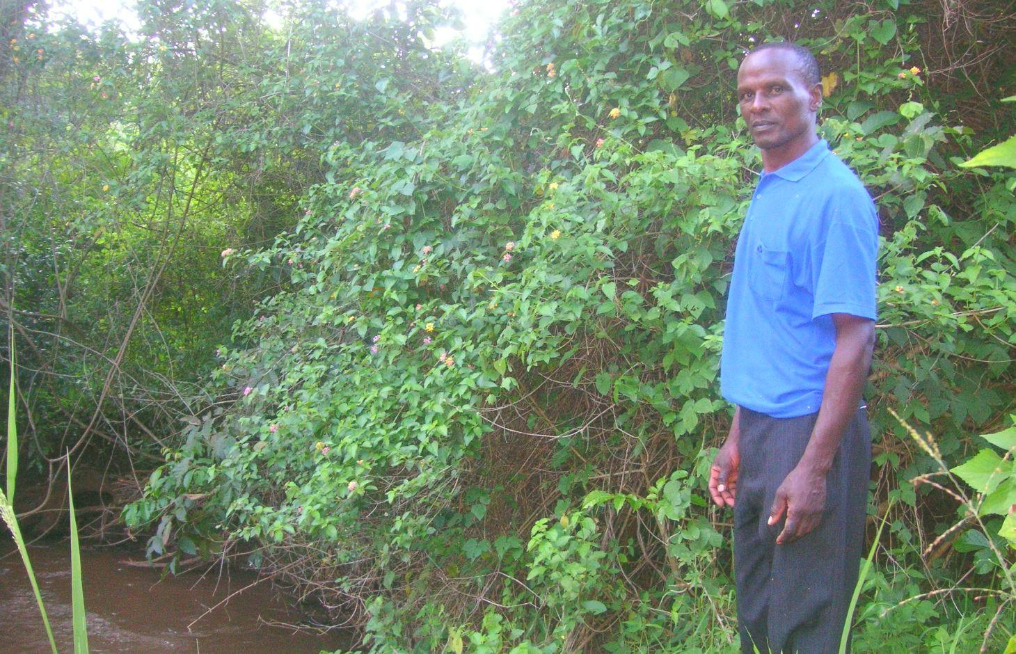
Njiru Fredrick
肯尼亚
有助于对技术进行记录/评估的机构名称(如相关)
CDE Centre for Development and Environment (CDE Centre for Development and Environment) - 瑞士1.3 关于使用通过WOCAT记录的数据的条件
编制者和关键资源人员接受有关使用通过WOCAT记录数据的条件。:
是
2. SLM技术的说明
2.1 技术简介
技术定义:
Protection of the riparian zone at Kapingazi River by leaving it undisturbed of human interference
2.2 技术的详细说明
说明:
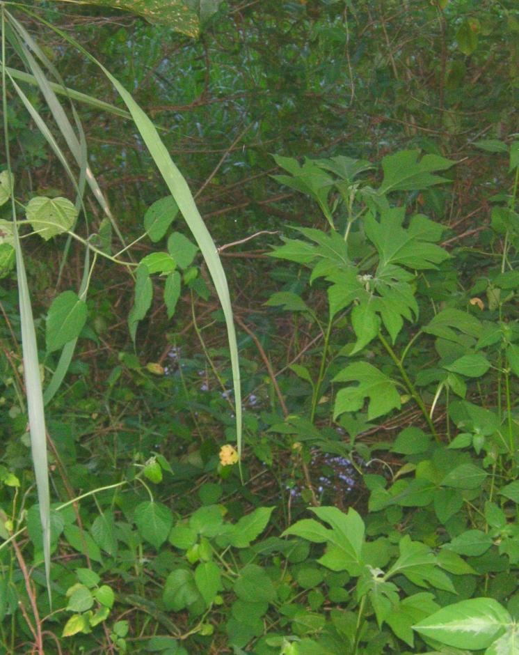
The farmers’ land plot is situated right alongside the river. Heavy floods have eroded a major part of the riverbank and have led to crop failures on the arable land. The farmer reacted to the degradation by stopping agriculture activities on a certain riparian area in order to enable natural vegetation to reclaim the area. The idea is that during the next years, further floods will deposit sediments, which will increase the elevation and fertility of the plot. As soon as enough soil has accumulated and the elevation has increased enough, the farmer wants to plant French beans in the area. Trees were planted in the riparian zone to stabilize the riverbank and to ensure water quality in the river by retaining sediments from nearby fields. Agricultural chemicals are trapped in the riparian buffer as well.
Purpose of the Technology: The purpose is to deal with the regular floods of Kapingazi River and to gain advantages for the farmer and the environmental conditions. Floods are a natural event and happen regularly, therefore strategies are necessary to diminish their negative effects. Furthermore, the human impact on a riparian ecosystem should be kept as small as possible by trapping chemicals and sediments that reduce water quality for down streamers.
Establishment / maintenance activities and inputs: The area where sediments are trapped is not touched by any human interference, the vegetation grows in its natural way. The stabilizing trees of the riparian are planted at the beginning of the rainy season in March or October. Dead seedlings have to be replaced regularly.
Natural / human environment: Kapingazi River is situated at the south eastern face of Mt. Kenya.It is an agriculturally favourable place due to abundant and reliable rainfall and fertile soils. The studied plot is located at an elevation of 1295 m.a.s.l where mainly maize and vegetables are cultivated. The precipitation amounts to 1150mm a year. Due to the good conditions, this area experiences a steady increase in both population growth and population density.
2.3 技术照片
媒体库
2.5 已应用该技术的、本评估所涵盖的国家/地区/地点
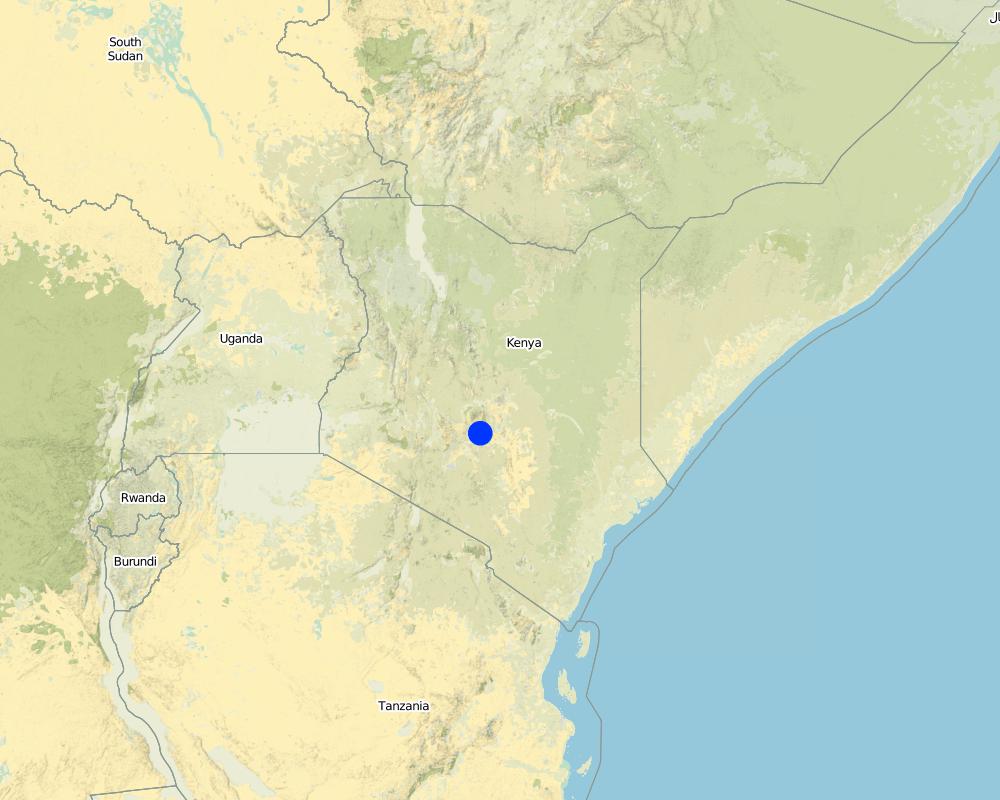
国家:
肯尼亚
区域/州/省:
Kenya/Eastern Province
有关地点的进一步说明:
Embu West
具体说明该技术的分布:
- 均匀地分布在一个区域
如果不知道精确的区域,请注明大致覆盖的区域:
- < 0.1 平方千米(10 公顷)
注释:
The area where the land use is applied locally is 10 acres. The farmer applies it on 2.5 acres on his 20 acres farm.
Map
×2.6 实施日期
如果不知道确切的年份,请说明大概的日期:
- 不到10年前(最近)
2.7 技术介绍
详细说明该技术是如何引入的:
- 通过土地使用者的创新
注释(项目类型等):
2 other people have introduced the same technology. Knowledge about riparian protection was also received through the water resource users association.
3. SLM技术的分类
3.1 该技术的主要目的
- 减少、预防、恢复土地退化
- 降低灾害风险
3.2 应用该技术的当前土地利用类型

农田
- 一年一作
- 乔木与灌木的种植
年作 - 具体指明作物:
- 谷物类 - 玉米
- 豆科牧草和豆类 - 豆子
- Mulinga (cordia africana), Moko (cordia monoica), Mokoego, Moo(Markhamia lutea), Muku (Aphananthe aspera), Mukuelgo, Muu
每年的生长季节数:
- 2
具体说明:
Longest growing period in days: 60 Longest growing period from month to month: march to may Second longest growing period in days: 60 Second longest growing period from month to month: october to november

森林/林地
- (半天然)天然森林/林地
- pruning
产品和服务:
- 木材
- 薪材
- 自然灾害防护
注释:
Trees/ shrubs species: Mulinga (cordia africana), Moko (cordia monoica), Mokoego, Moo(Markhamia lutea), Muku (Aphananthe aspera), Mukuelgo, Muu
Major land use problems (compiler’s opinion): Riverbank degradation and small riparian area.
Major land use problems (land users’ perception): Riverbank degradation and destroyed yield due to floods.
Other type of forest: pruning
Forest products and services: timber, fuelwood, protection against natural hazards
Future (final) land use (after implementation of SLM Technology): Forests / woodlands: Fn: Natural
3.3 由于技术的实施,土地使用是否发生了变化?
由于技术的实施,土地使用是否发生了变化?:
- 是(请在技术实施前填写以下有关土地利用的问题)
农田
- 一年一作
3.4 供水
该技术所应用土地的供水:
- 雨养
3.5 该技术所属的SLM组
- 区域封闭(停止使用,支持恢复)
- 地表水管理(泉、河、湖、海)
3.6 包含该技术的可持续土地管理措施

植物措施
- V1:乔木和灌木覆盖层

管理措施
- M1:改变土地使用类型
注释:
Main measures: vegetative measures, management measures
Type of vegetative measures: aligned: -along boundary
3.7 该技术强调的主要土地退化类型

土壤水蚀
- Wr:河岸侵蚀

生物性退化
- Bc:植被覆盖的减少

水质恶化
- Hp:地表水水质下降
注释:
Main type of degradation addressed: Wr: riverbank erosion, Hp: decline of surface water quality
Secondary types of degradation addressed: Bc: reduction of vegetation cover
Main causes of degradation: deforestation / removal of natural vegetation (incl. forest fires), over-exploitation of vegetation for domestic use, Heavy / extreme rainfall (intensity/amounts) (due to climate change?), floods, education, access to knowledge and support services (lack of education)
3.8 防止、减少或恢复土地退化
具体数量名该技术与土地退化有关的目标:
- 防止土地退化
- 修复/恢复严重退化的土地
4. 技术规范、实施活动、投入和成本
4.1 该技术的技术图纸
技术规范(与技术图纸相关):
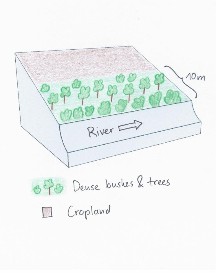
The riparian area was regularly affected by floods and riverbank erosion. The land user decided to stop cultivation which allows the development of riparian vegetation to stabilize the riverbank and to raise the elevation.
Location: Embu. Embu West / Eastern Province
Date: 28.12.2013
Technical knowledge required for field staff / advisors: moderate
Technical knowledge required for land users: moderate
Main technical functions: stabilisation of soil (eg by tree roots against land slides)
Secondary technical functions: improvement of ground cover, sediment retention / trapping, sediment harvesting, promotion of vegetation species and varieties (quality, eg palatable fodder)
Aligned: -along boundary
Number of plants per (ha): 33 on 450m
Vertical interval within rows / strips / blocks (m): 3-15
Trees/ shrubs species: Mulinga (cordia africana), Moko (cordia monoica), Mokoego, Moo(Markhamia lutea), Muku, Mukuelgo, Muu
Change of land use type: A plot of cropland was converted to a forest that consists mostly of dense bushes and trees.
作者:
Manuel Fischer
4.2 有关投入和成本计算的一般信息
具体说明成本和投入是如何计算的:
- 每个技术单元
指定单位:
Riparian area
指定单位面积(如相关):
450 m
具体说明成本计算所用货币:
- 美元
注明雇用劳工的每日平均工资成本:
2.70
4.3 技术建立活动
| 活动 | 时间(季度) | |
|---|---|---|
| 1. | Planting tree seedlings | During rainy season |
| 2. | Replant dead tree seedlings | During rainy season |
| 3. | change of land use |
4.4 技术建立所需要的费用和投入
| 对投入进行具体说明 | 单位 | 数量 | 单位成本 | 每项投入的总成本 | 土地使用者承担的成本% | |
|---|---|---|---|---|---|---|
| 劳动力 | Planting tree seedlings | Persons/day | 2.0 | 3.5 | 7.0 | 100.0 |
| 劳动力 | Replant dead tree seedlings | Persons/day | 2.0 | 3.5 | 7.0 | 100.0 |
| 植物材料 | Seedlings | pieces | 33.0 | 0.111 | 3.66 | 100.0 |
| 植物材料 | Seedlings for replanting | pieces | 12.0 | 0.111 | 1.33 | 100.0 |
| 技术建立所需总成本 | 18.99 | |||||
| 技术建立总成本,美元 | 18.99 | |||||
注释:
Duration of establishment phase: 0.2 month(s)
4.6 维护/经常性活动所需要的费用和投入(每年)
注释:
Machinery/ tools: Jembe
The costs were calculated for a riparian area with a length of 100m and a width of 10m, since hectares are difficult to apply on a riparian context. The determinant factor for the costs is labour. In this case, the costs are very low because the trees were only planted every 10 metres along the riparian. The seedlings must be bought in a nursery. Most of the bushes regrow naturally and do not need any care.
Some of the seedlings had to be replanted, because they dried up. The required equipment like a spade is available on nearly every farm or can be borrowed from neighbours and is thus not added to the costs.
5. 自然和人文环境
5.1 气候
年降雨量
- < 250毫米
- 251-500毫米
- 501-750毫米
- 751-1,000毫米
- 1,001-1,500毫米
- 1,501-2,000毫米
- 2,001-3,000毫米
- 3,001-4,000毫米
- > 4,000毫米
农业气候带
- 半湿润
Thermal climate class: tropics
5.2 地形
平均坡度:
- 水平(0-2%)
- 缓降(3-5%)
- 平缓(6-10%)
- 滚坡(11-15%)
- 崎岖(16-30%)
- 陡峭(31-60%)
- 非常陡峭(>60%)
地形:
- 高原/平原
- 山脊
- 山坡
- 山地斜坡
- 麓坡
- 谷底
垂直分布带:
- 0-100 m a.s.l.
- 101-500 m a.s.l.
- 501-1,000 m a.s.l.
- 1,001-1,500 m a.s.l.
- 1,501-2,000 m a.s.l.
- 2,001-2,500 m a.s.l.
- 2,501-3,000 m a.s.l.
- 3,001-4,000 m a.s.l.
- > 4,000 m a.s.l.
关于地形的注释和进一步规范:
Altitudinal zone: 1298 m a.s.l.
5.3 土壤
平均土层深度:
- 非常浅(0-20厘米)
- 浅(21-50厘米)
- 中等深度(51-80厘米)
- 深(81-120厘米)
- 非常深(> 120厘米)
土壤质地(表土):
- 细粒/重质(粘土)
表土有机质:
- 中(1-3%)
如有可能,附上完整的土壤描述或具体说明可用的信息,例如土壤类型、土壤酸碱度、阳离子交换能力、氮、盐度等。:
Soil fertility is high
Soil drainage / infiltration is medium
Soil water storage capacity is very high
5.4 水资源可用性和质量
地下水位表:
< 5米
地表水的可用性:
好
水质(未处理):
仅供农业使用(灌溉)
关于水质和水量的注释和进一步规范:
Availability of surface water: Sometimes floods, during rains
5.5 生物多样性
物种多样性:
- 中等
5.6 应用该技术的土地使用者的特征
生产系统的市场定位:
- 混合(生计/商业)
非农收入:
- 低于全部收入的10%
相对财富水平:
- 丰富
个人或集体:
- 团体/社区
机械化水平:
- 手工作业
性别:
- 女人
- 男人
说明土地使用者的其他有关特征:
Land users applying the Technology are mainly Leaders / privileged
Population density: > 500 persons/km2
5.7 应用该技术的土地使用者使用的平均土地面积
- < 0.5 公顷
- 0.5-1 公顷
- 1-2 公顷
- 2-5公顷
- 5-15公顷
- 15-50公顷
- 50-100公顷
- 100-500公顷
- 500-1,000公顷
- 1,000-10,000公顷
- > 10,000公顷
这被认为是小规模、中规模还是大规模的(参照当地实际情况)?:
- 小规模的
注释:
Average area of land owned or leased by land users applying the Technology: Also 5-15 ha for cropland and 0.5 - 1 ha for woodland
5.8 土地所有权、土地使用权和水使用权
土地所有权:
- 个人,未命名
土地使用权:
- 个人
用水权:
- 社区(有组织)
5.9 进入服务和基础设施的通道
健康:
- 贫瘠
- 适度的
- 好
教育:
- 贫瘠
- 适度的
- 好
技术援助:
- 贫瘠
- 适度的
- 好
就业(例如非农):
- 贫瘠
- 适度的
- 好
市场:
- 贫瘠
- 适度的
- 好
能源:
- 贫瘠
- 适度的
- 好
道路和交通:
- 贫瘠
- 适度的
- 好
饮用水和卫生设施:
- 贫瘠
- 适度的
- 好
金融服务:
- 贫瘠
- 适度的
- 好
6. 影响和结论性说明
6.1 该技术的现场影响
社会经济效应
生产
作物生产
饲料生产
木材生产
注释/具体说明:
Through prunning
社会文化影响
SLM/土地退化知识
生态影响
水循环/径流
水量
注释/具体说明:
in river
水质
地表径流
土壤
土壤覆盖层
土壤流失
生物多样性:植被、动物
植物多样性
动物多样性
有益物种
栖息地多样性
减少气候和灾害风险
洪水影响
其它生态影响
Riverbank erosion
6.2 该技术的场外影响已经显现
水资源可用性
旱季稳定可靠的水流
地下水/河流污染
缓冲/过滤能力
6.3 技术对渐变气候以及与气候相关的极端情况/灾害的暴露和敏感性(土地使用者认为的极端情况/灾害)
渐变气候
渐变气候
| 季节 | 增加或减少 | 该技术是如何应对的? | |
|---|---|---|---|
| 年温度 | 增加 | 好 |
气候有关的极端情况(灾害)
气象灾害
| 该技术是如何应对的? | |
|---|---|
| 局地暴雨 | 好 |
| 局地风暴 | 好 |
气候灾害
| 该技术是如何应对的? | |
|---|---|
| 干旱 | 好 |
水文灾害
| 该技术是如何应对的? | |
|---|---|
| 比较和缓的(河道)洪水 | 好 |
其他气候相关的后果
其他气候相关的后果
| 该技术是如何应对的? | |
|---|---|
| 缩短生长期 | 好 |
6.4 成本效益分析
技术收益与技术建立成本相比如何(从土地使用者的角度看)?
短期回报:
轻度消极
长期回报:
稍微积极
技术收益与技术维护成本/经常性成本相比如何(从土地使用者的角度看)?
短期回报:
中性/平衡
长期回报:
稍微积极
6.5 技术采用
- 单例/实验
如若可行,进行量化(住户数量和/或覆盖面积):
1 household
在所有采用这项技术的人当中,有多少人是自发的,即未获得任何物质奖励/付款?:
- 91-100%
注释:
There is a moderate trend towards spontaneous adoption of the Technology
Comments on adoption trend: The other farmers noticed the positive impacts and adopt the technology.
6.7 该技术的优点/长处/机会
| 土地使用者眼中的长处/优势/机会 |
|---|
|
There are no more crop failures and the riverbank is stabilized How can they be sustained / enhanced? In the other areas that are not much more elevated than the river, flood resistant plants like Napier grass should be planted. |
|
The trees and the riparian bushes provide timber and fuelwood. How can they be sustained / enhanced? Careful use of the resources ensures sustainability. |
| 编制者或其他关键资源人员认为的长处/优势/机会 |
|---|
|
The established forest is a great success for the local fauna and flora in terms of biodiversity How can they be sustained / enhanced? More areas like this could be established |
6.8 技术的弱点/缺点/风险及其克服方法
| 土地使用者认为的弱点/缺点/风险 | 如何克服它们? |
|---|---|
| The shrub-covered area is no longer available for cultivation and leads to a decrease in income. | If the farmer depends on the productivity of the riparian, he could plant Napier grass and prune the trees. |
| 编制者或其他关键资源人员认为的弱点/缺点/风险 | 如何克服它们? |
|---|---|
| As soon as the riparian forest is silted up and floods become more rare, the farmer plans a deforestation and cultivation of beans in the riparian area with riparian vegetation strips of 5m. | The riparian forest should be kept there to improve ecological benefits and to sustain reduced erosion. |
7. 参考和链接
7.1 信息的方法/来源
链接和模块
全部展开 全部收起链接
无链接
模块
无模块